Thursday 24th May 2018 – Bank Holiday Monday 28th May 2018

Hi all,

You guys must be loving me at the moment. It’s not often I deliver good news but it’s another blog and another week of decent summer-like weather on the way, but, we have to discount Friday in that claim.

Remember at this time of year the sun is as strong as mid-July, UV levels are HIGH at 6/7, so apply sun-cream if you’re planning to be out in it for a while, otherwise you will burn regardless of what the temperature is.

Thursday: Warm with bright spells and dry. We will still have the steady breeze from the northeast and with that, more cloud than we have been seeing recently. That said, it will still be feeling pleasant in any sunshine. Max 20°C

Friday: A day off from the decent weather. Cloudy with rain during the morning coming in from the east. Some of this could be heavy and thundery. A bit brighter later but with a few scattered beefy showers. Much cooler. Max 15°C

Extended Weekend: Sun-cream and BBQs are on the menu.

Saturday: Some cloud leftover from yesterday with perhaps a scattered early shower to start the day. The sun will get to work on this cloud, allowing it to break up and return us to what we are getting accustomed to. Sunny spells and dry for the rest of the day. Also, notably warmer again but still breezy. Max 20°C

ukmaxtemp

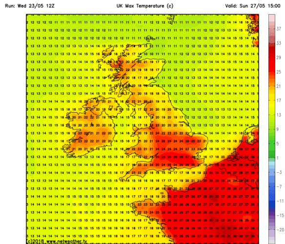
Sunday: Sunny and dry with temperatures rising. Feeling muggy and humid later as we drag in air from France. Hot in places. Max 24°C but this could go a degree or two higher.

Bank Holiday Monday: Very warm with plenty of strong sunshine. A chance of evening thunderstorms breaking out [one to watch]. Max 23°C

Throughout the forecast we will keep a steady breeze which will help you to cool off during the day but also make it a little cool in some of the evenings.

Outlook: Downpours and thunderstorms will introduce fresher air but this should be followed by sunny spells and mainly dry conditions once again.

Follow @ChadWeather on Twitter for the latest forecasts.

Thanks,
Jon

Forecast issued at 8:10pm on Wednesday the 23rd of May 2018
Image: https://www.netweather.tv/


Thursday 17th May 2018 – Sunday 20th May 2018

Hi all,

May is turning out to be a decent month and this settled, warm pattern with little rain, is set to continue. I’m sure we will pay for this during the summer months so grab it while you can.

Thursday: Still not as warm as earlier in the week but a good day in prospect. Sunny spells with yesterday’s breeze easing. Max 15°C

Friday: Settled with lengthy spells of sunshine. Temperatures back on the rise. Max 17°C

Weekend: Simply lovely.

Saturday: Warm with sunshine across the region. Light winds so really feeling summer-like. Max 21°C

Sunday: Little change. Just probably more in the way of cloud bubbling up especially so in eastern parts. Warm and dry. Max 21°C

Outlook: Similar to last Wednesday on Monday with cloud spreading down from the northwest. This will bring a very weak band of rain which will fizzle out. It will turn cooler though. After that high pressure reestablishes itself so we will be dry and become warmer again with sunny spells.

Looking towards the Bank Holiday Weekend and it currently pans out with high pressure in charge which means warm sunny weather – but don’t take this literally this far out.

Remember at this time of year the sun is as strong as late-July, UV levels are HIGH at 6, so apply sun-cream if you’re planning to be out in it for a while, otherwise you will burn regardless of what the temperature is.

Follow @ChadWeather on Twitter for frequent updates.

Forecast issued at 5:45pm on Wednesday the 16th of May 2018.

Thanks,
Jon

Thursday 10th May 2018 – Sunday 13th May 2018

Hi all,

So that’s two very warm summer-like spells of weather so far this year. Can’t grumble and no they weren’t heatwaves. So when’s the next one please? I’m getting itchy feet :).

Thursday: Any early cloud from last night’s rain soon clearing and a reasonable day with plenty of sunny spells. Feeling warm in the sunshine. Max 14°C

Friday: Sunny spells for the morning but turning breezy and cloudier into the afternoon. Rain arriving into late-evening and overnight. Max 15°C

Weekend: Much cooler than last week but not too shabby.

Saturday: Sunny spells and temperatures nothing to cheer about, but feeling pleasant in the sunshine again with light winds. A risk of some showers from the south-west towards evening. Max 14°C

Sunday: Bright spells and it should be dry as we keep a band of rain away to our east and showers away to our south-west. Just a chance of developing a shower over the Pennines or hills. Max 14°C

Remember at this time of year the sun is as strong as early-August, UV levels are at 6, so apply sun-cream if you’re planning to be out in it for a while, otherwise you will burn regardless of what the temperature is.

Outlook: Hopefully high pressure will build to the south-west of the UK, so expect it to turn warmer, not hot, with decent spells of sunshine. Temperatures in the upper teens. Variable amounts of cloud at times, a slight breeze and mostly dry.


Follow @ChadWeather on Twitter for the very latest.

Thanks,
Jon

Forecast issued at 2pm on Wednesday the 9th of May 2018

Thursday 3rd May 2018 – Bank Holiday Monday 7th May 2018

Hi all,

After a reasonable April we move into May with some decent, settled weather on the way and it’s not often we can say that with a Bank Holiday approaching.

Thursday: A chilly start with high pressure building to the southwest of the UK starting to settle the weather down after Wednesday’s rain. Mostly dry with some bright spells. However, a little later, the airflow will thicken the cloud and there could be some isolated areas of drizzle. Max 13°C

Friday: Plenty of cloud again, but with some bright spells thrown in, especially to the east. Just a low chance of a shower breaking out over the hills as temperatures begin to rise. A south-westerly breeze but warmer. Max 17°C

Weekend: It could be a lot worse with it being an extended one.

Saturday: Some sunny spells developing. Feeling very warm, especially in any sunshine. Max 20°C

Sunday: Pleasant sunny spells. A northwesterly breeze will develop so a little cooler and perhaps cloudier later. Max 19°C

Bank Holiday Monday: This is rare! It’s a Bank Holiday and we’ll have very warm sunny spells and it will be dry. Max 21°C

Remember at this time of year the sun is as strong as mid-August, UV levels are 5 to 6, so apply sun-cream if you’re planning to be out in it for a while, otherwise you will burn.

Outlook: A couple more days of settled dry weather with sunshine before a change. This change brings low pressure to the northwest of the UK allowing it to turn cooler and showery. This is not set in stone but just the more likely outcome.

April 2018 Stats

Max 22.8°C (19th)
Min 0.4°C (5th)
Av. 8.8°C
Wettest 22.2mm (2nd)
Windiest 35mph
Rain 78.8mm
Rainy Days 17
Dry Days 13

Follow @ChadWeather on Twitter for the very latest.

Thanks,
Jon