Winter is here – Cold for the foreseeable, but how cold later next week as the chance of seeing some snow increases? – Thursday 1st December 2022 – Sunday 4th December 2022

Hi all,

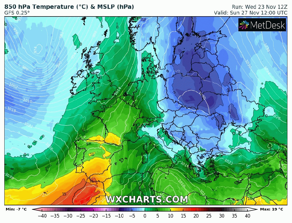
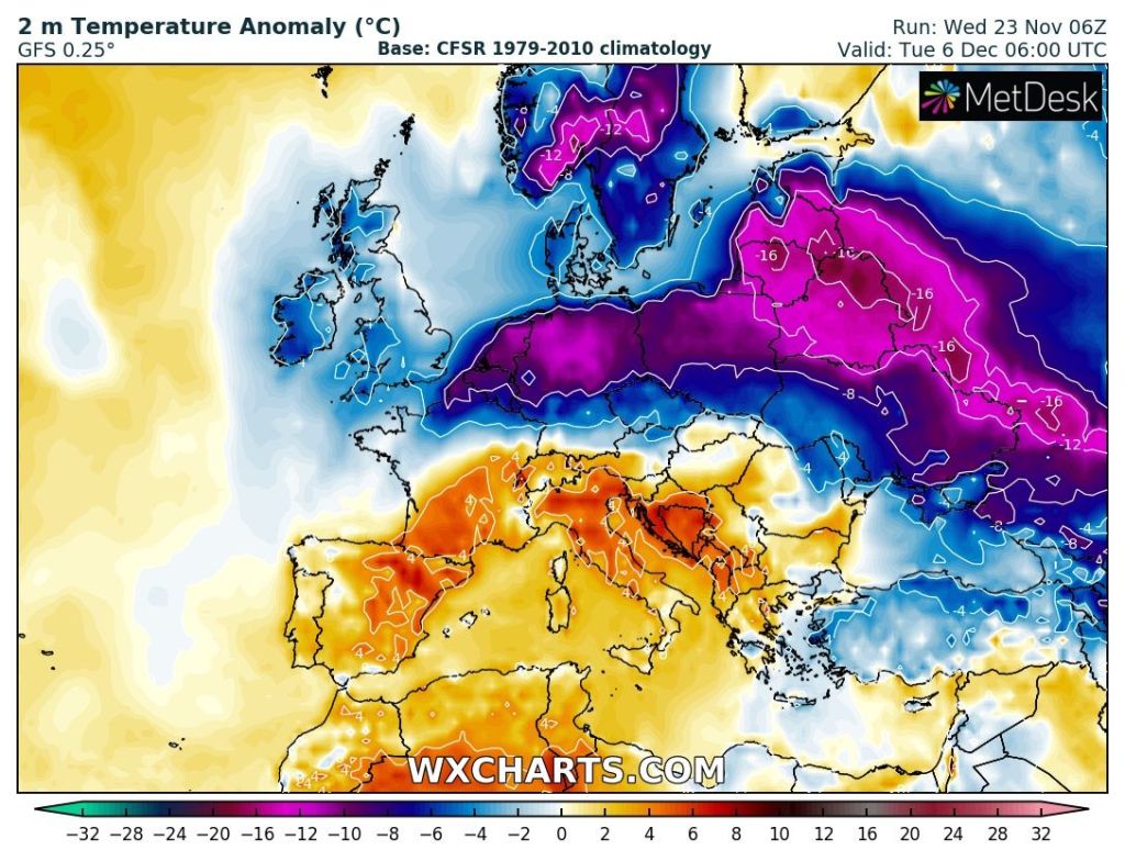
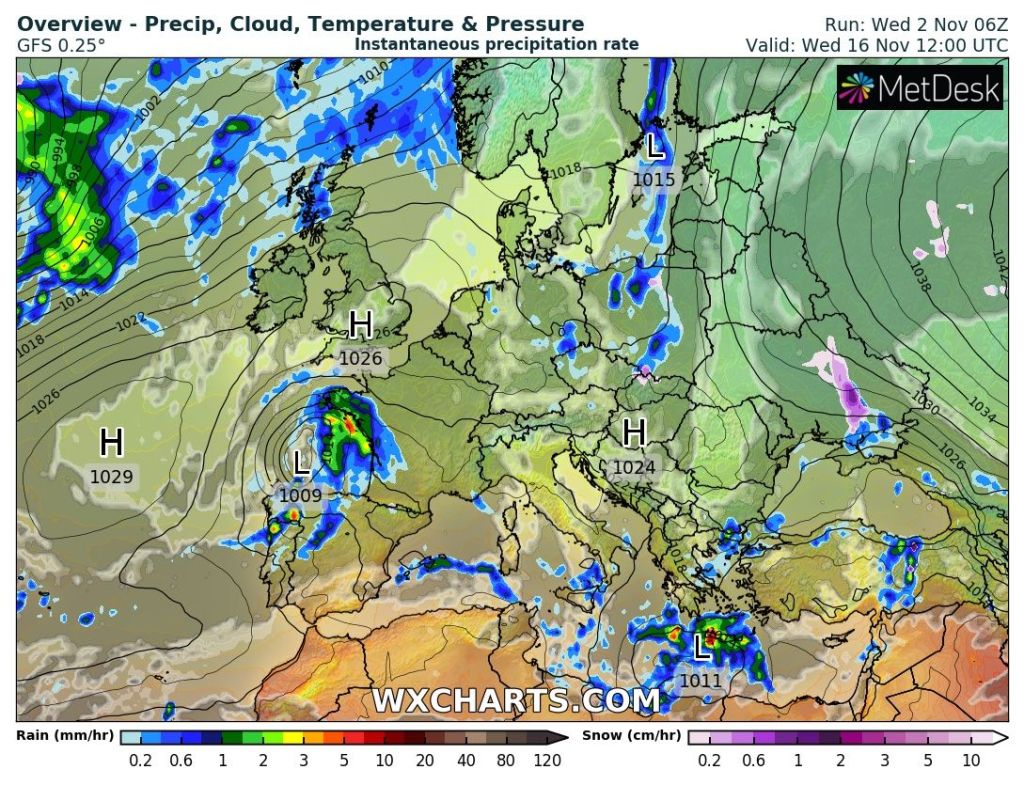
Winter, meteorologically-speaking is here. We ended Autumn as we start Winter, with below-average temperatures and with the weather set in a pattern. A huge high pressure across eastern Europe, originally building over Scandinavia is controlling our weather. When this happens, we can drag in cloud off the still relatively warm North Sea and hence have days on end of little change. The doom and gloom can come in the form of fog/low-cloud especially with little wind and with any brightness to the west or even as far west as the coast. We are currently in this predicament but slight changes are on the way.

Below average temperatures for the foreseeable.

Thursday: Similar to recent days. A lot of cloud, low-cloud on the hills, mostly overcast and cold. That said temperatures could be a degree of two up on recent days. Max 7°C

Friday: A slight easterly breeze in place with plenty of cloud being dragged in from the North Sea. The cloud could be thick enough at times for the odd patch of drizzle first-off. As the day progresses, little change but perhaps the odd bright spell to the west. Max 6°C

Weekend: Slowly colder with the breeze picking up leading to a windchill and showers possible.

Saturday: Generally cloudy with a raw easterly breeze. Mostly dry with any lucky spots seeing limited brightness, mainly to the west. Dry but the odd shower may occur. Max 5°C

Sunday: Overcast with a keen wind and cold with a feels-like temperature of 0°C. Can’t rule out an isolated shower which would be wintry on the tops of the Pennines. Max 5°C

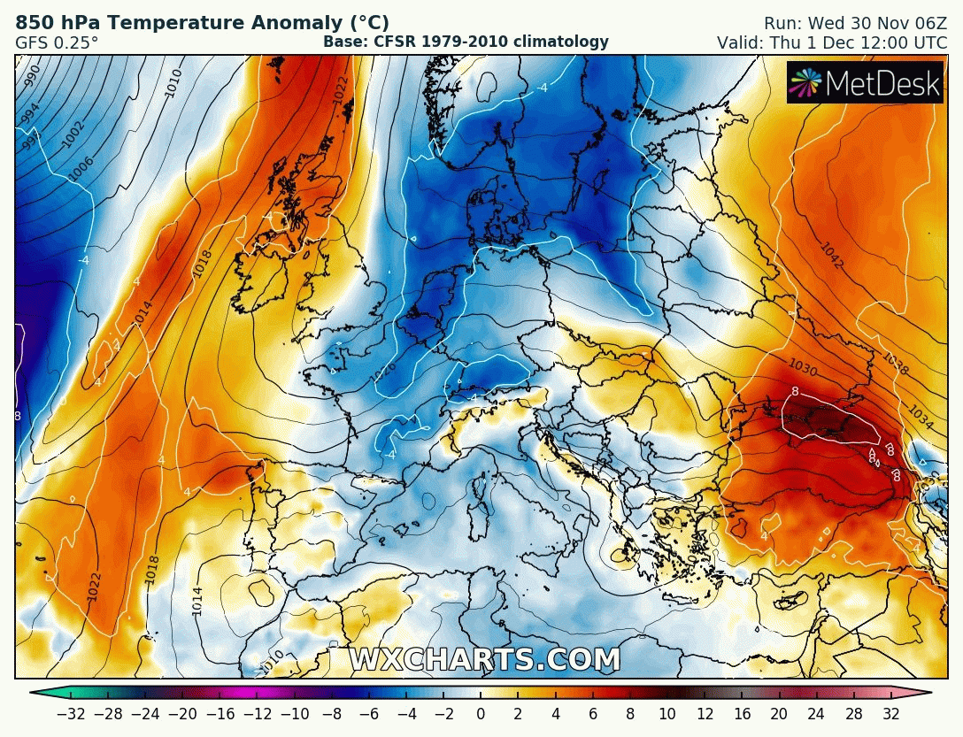
Outlook: Very little change for the next couple of days but after that does look interesting as there’s the potential for high pressure to build towards Greenland and low pressure over Scandinavia which will allow for a cold northerly airflow to develop, straight from the Arctic. Nothing extremely cold but cold enough for a few snow showers, even to lower-levels. Temperatures look set to remain below-average with the risk of wintry showers increasing. The second week of December could see a battlefield developing. Will milder air push in from the south-west or could it turn much colder from the east; not exactly what we need with energy prices! Watch this space.

Cold air engulfs Europe, including the UK, over the next 10 days.

Follow @ChadWeather on Twitter for the latest forecasts and warnings.

Thanks,
Jon

Forecast Issued: Wednesday the 30th of November 2022 at 7:50pm.
Images: http://www.wxcharts.com

Little change but cold lurking in eastern Europe brings snow to the charts – Thursday 24th November 2022 – Sunday 27th November 2022

Hi all,

The typical autumnal weather continued over the past week with further rain taking the month total to 95mm. The recent pattern is set to continue then a few models are hinting at a drier, more settled start to December with a possible cold spell with frost and fog on the horizon.

Colder weather lurks to the east. If this potential hangs around don’t be surprised to hear the phrase Beast from the East in the media again 🤣.

Thursday: A bright start with some sunny spells. Winds will increase, locally 35mph later, as cloud thickens from the southwest. A band of rain, some heavy will move through the region during the afternoon. Showers follow later. Max 9°C

Friday: Not a bad day with sunny spells after morning-showers fade away. Windy though. Max 10°C

Weekend: Rain returns but milder.

Saturday: Any brightness fading as cloud thickens into the afternoon. Rain will arrive later and it will bring with it milder air from the south-west. Windy. Max 11°C

Sunday: Early rain clears to a mostly cloudy picture and the odd scattered shower. Breezy. Max 11°C

Outlook: Becoming cooler again with temperatures around or perhaps just below average. Some rain or showers at first but high pressure is favourable to build in and settle things down; so becoming drier and with some frost and fog where skies clear. Beyond that there are a few hints of a cold easterly or north-easterly airflow setting up which could deliver the first cold spell of winter. For now though, as always, it’s too far away to confirm.

A cold Europe and the pool of cold builds into next week but how far west will it get? First blast of Winter or will this idea disappear from the models soon?
Just for fun: With a cold easterly comes snow showing on the charts. Shame this is 16 days away and unlikely to verify.

Follow @ChadWeather on Twitter for the latest forecasts and warnings.

Thanks,
Jon

Forecast Issued: Wednesday the 23rd of November 2022 at 6:30pm
Images: http://www.wxcharts.com

Cool and mostly unsettled with a rain warning – Thursday 17th November 2022 – Sunday 20th November 2022

Hi all,

Further unsettled weather coming later this week and we are now back into a more typical autumn with daytime temperatures struggling to get into double-figures; Wednesday only peaked at 8.5°C.

After over half-an-inch of rain here and up to an inch in some places on Tuesday, we’ll see more of the same on Thursday and we have a warning in place.

Areas under the yellow warning and more details on the rain due

Thursday: Cloudy with periods of rain with heavy bursts at times. Breezy and a cool feel with a north-westerly airflow. It should turn drier slowly as the evening wears on. Max 10°C

Friday: Westerly winds quite strong and gusty. Another unsettled day with frequent showers and limited bright spells. Max 9°C

Weekend: Saturday’s the best day.

Saturday: A cold start with a localised ground-frost and a few mist patches. A dry day with bright or sunny spells. Rain will arrive overnight, or even late-evening. Max 9°C

A brief ridge of high pressure will bring a better day on Saturday

Sunday: Morning rain moving on to be followed by showers, which could contain hail. Windy and feeling cold with temperatures likely to struggle. Max 8°C

Outlook: Perhaps a respite on Monday before the week turns unsettled once again with bouts of rain/showers and wind as low pressure takes charge. We will be on the north side of the Jet Stream so temperatures cool but generally around average. Long gone are those late-teens temperatures.

Maximum temperatures staying on the cool side

Follow @ChadWeather on Twitter for the latest forecasts and warnings.

Thanks,
Jon

Forecast Issued: Wednesday the 16th of November 2022 at 4:50pm.
Images: Met Office & http://www.wxcharts.com

Drier for a time and exceptionally mild – Thursday 10th November 2022 – Sunday 13th November 2022

Hi all,

After a wet October it’s been quite a wet start to November too. We’re in for some mainly dry days now but it will be very windy too, and, as mentioned, very mild. Signs of it turning a bit cooler next week and with it the possibility of severe gales in places and yet more rain.

Thursday: After a very mild night the day will continue on the warmer-than-average front with moist southwesterly winds. These winds will be gusty, 30-35mph and will bring plenty of cloud. Risk of some drizzle, especially on the hills. Max 16°C

Thursday night’s minimum temperatures could well be record-breaking for November across parts of the UK, especially sheltered from the wind and in favourable locations.

Temperatures still around the mid-teens during the early hours of Friday morning

Friday: Another very mild and cloudy day with gusty winds. It should be dry for most and hopefully some bright spells later in the day as cloud breaks from the south. Max 16°C

Weekend: Sunnier Saturday.

Saturday: A southeasterly wind will bring in slightly cooler air and also drier air leading to a dry day with plenty of sunny spells developing. Sounds like a day in the garden to get it ready for winter. Max 13°C

Sunday: Bright morning but cloud increasing as the day wears on. Fresh breeze. Max 13°C

Outlook: Becoming increasingly unsettled with low pressures coming in off the Atlantic. These will need monitoring as there is a risk of them becoming deep and bringing spells of heavy rain and gales or even severe gales. After a mild start it looks set to become cooler or even colder with max temperatures around 9-11°C.

The potential for some deep areas of low pressure later next week

Follow @ChadWeather on Twitter for the latest forecasts and warnings.

Thanks,
Jon

Forecast Issued: Wednesday the 9th of October 2022 at 5:35pm
Images: http://www.wxcharts.com

Chilly with a better end to the working week before turning unsettled again – Thursday 3rd November 2022 – Sunday 6th November 2022

Hi all,

October turned into a wet month with rainfall totals above average. It was the wettest month since February with 115.6mm of rain. It was also notably very mild to warm at times. We didn’t reach the dizzy heights of temperatures into the 20s like they did down south but plenty of days saw the mid-teens and night temperatures also staying into double-figures.

November has started off on a windy and cooler note with temperatures more around normal. There isn’t any sign of significantly colder weather on the way despite media reports.

Thursday: A fresh start with plenty of sunny spells and perhaps a rogue shower. Clouds will increase and a scattering of showers will develop. Feeling chilly. Breezy but not as windy as yesterday. Max 11°C

Friday: A decent day with sunny spells. Cloudier at times later, with the chance of a few showers off the Irish Sea, but skies clearing again overnight and becoming cold with the risk of a ground-frost in rural and sheltered spots. Lighter winds. Max 11°C

Weekend: Turning more unsettled again.

Saturday: After a dry start, cloud will thicken from the west and the winds will increase. Rain will spread east as the day progresses, heavy at times then turning patchy towards evening. Apart from a few showers I’m hopeful that it could be mainly dry in time for the bonfires and fireworks. Max 12°C

Sunday: Windy with bright spells and showers developing. Max 12°C

Outlook: It’s looking wet with rain or showers on Monday and Tuesday but with the strong and gusty wind coming from the south or south-west it will become milder again, 14-15°C. Later in the week there’s a chance high pressure will build as the Jet Stream buckles. So fingers crossed for something drier and more settled but remaining milder-than-average for now.

High pressure building second half of next week?

October 2022 Stats

Max 16.7°C (29th)
Min 5.6°C (18th)
Av. 11.8°C
Wettest 24.8mm (5th)
Av. Humidity 86%
Av. Barometer 1012.7 hPa
Max Gust 31.1mph
Av. Wind Direction SSW
Rain 115.6mm (above average)
Rain Registered Days 26
Dry Days 5

Follow @ChadWeather on Twitter for the latest forecasts and warnings.

Until next week. Thanks for reading.
Jon

Forecast Issued on Wednesday the 2nd of November 2022 at 8:30pm.
Image: http://www.wxcharts.com