Thursday 1st June 2017 – Sunday 4th June 2017

Hi all,

After a lovely Wednesday with plenty of sunshine what’s in store as we enter our meteorological Summer.

Thursday: A cloudy day with some brightness especially during the morning. We drag up air from the South so turning humid and muggy. Max 22°C

Friday: A muggy day. Cloud will thicken and rain, perhaps heavy and thundery, will arrive from the west. After a humid start it will slowly become fresher. Max 17°C

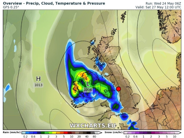
Saturday: Westerly winds back in charge so cooler and fresher but with some nice sunny spells and a few showers. Max 16°C

Sunday: Not much change. Sunshine and showers. Pleasant in any sunshine this weekend as the sun is strong as this time of the year. Max 16°C

Outlook: Low pressure to our north at times and high pressure to our south, so basically a sunshine and showers mixture. Perhaps breezy at times and temperatures around normal or just below with some cool nights.

As always the British weather is very changeable, so keep up-to-date with your local weather by following @ChadWeather on Twitter.

Thanks,
Jon

Forecast Issued: Wednesday the 31st of May 2017 at 2:20pm

Thursday 25th May 2017 – Bank Holiday Monday 29th May 2017

Hi all,

After some welcome rain last week, it’s time to turn up the heat as we experience our first taste of Summer temperatures. However, after initially hoping it would last all weekend, it is now looking like Friday will be the warmest day with a cooling trend over the weekend.

High pressure has built in across the UK as this week has gone on and with it comes some very warm and humid air from the southeast.

High pressure brings us a short spell of hot & humid sunny weather

Thursday: Dry with sunny spells developing and with light winds it will feel humid and becoming hot. Max 26°C

Friday: A little breeze will develop but this coming from the southeast will only help import warmer air. Feeling hot and humid with plenty of sunny skies. Max 26°C

Saturday: Low pressure bringing a showery breakdown of the heat with possible thunderstorms

Saturday: Feeling very humid to start the day with some sunny spells but less sunshine later as low pressure tracks in from the southwest. During the day we can expect a breakdown from the hot and humid conditions with heavy, possibly thundery, showers coming in from the west. Fresher air will follow, which will be welcome. Max 23°C

Sunday: Cooler as fresher air takes over from the west. Some sunny spells but with a risk of showers. Temperatures down on recent days, welcome news for the Great Manchester Run. Max 19°C

Bank Holiday Monday: A westerly airflow across the region. Some bright spells but thicker cloud at times too. Max 18°C

Follow @ChadWeather on Twitter for the very latest weather forecasts.

Thanks,
Jon

Forecast Issued: Wednesday May the 24th at 12:30pm

Images: http://wxcharts.eu

Thursday 18th May 2017 – Sunday 21st May 2017

Hi all,

Well the rain certainly returned this week and all of a sudden everywhere looks green and is growing. It was much-needed rain but it’s already time the sun returned. 

Quite a complex set-up these coming days with timing tricky on when it will rain etc.; as always is the case with showers. 

Thursday: A much-improved day than recently with sunny spells and a scattering of heavy showers. Feeling fresher after some humid days. Max 16°C

Friday: A bright start but with low pressure close by to our west, cloud will bubble up during the day with showers arriving. Max 15°C

A showery weekend
Saturday & Sunday: Bright spells and showers. Catch a shower and it could be heavy with hail and thunder and it will feel cool as temperatures drop. Pleasant in any prolonged sunshine. Max 14°C

Any clear spells overnight will lead to quite chilly conditions and even though the risk isn’t that high, we could see the odd rural groundfrost.

Outlook: Showery then hopefully high pressure will build and kill off the showers and allow for some sunshine. However, it doesn’t look set to last with showery conditions returning. Remaining fresh. 

Follow @ChadWeather on Twitter for the very latest weather forecasts. 

Thanks,
Jon

Image: http://wxcharts.eu

Forecast Issued: Wednesday May the 17th at 2:15pm

Thursday 11th May 2017 – Sunday 14th May 2017

Hi all,

After only 20% of the monthly average rainfall in April we’re now 11 days into May and we’ve had zero rainfall, but that’s all about to change.

Headline: We lose the very dry and settled conditions that we’ve had for several weeks as the weather changes to come from the more usual west/southwest direction. 

Thursday: Another (last one) sunny day. The sun will turn hazy later on. Feeling very warm and in the early hours of Friday a chance of some heavy showers. Max 19°C

Friday: Cloudy with some heavy showers. These could turn thundery during the day. Some bright spells in between. Much-needed rainfall so we can’t complain. Remaining quite warm though. Max 16°C

A mixed weekend ahead.

Saturday: Sunshine and a few showers of which could be heavy but well-scattered. Feeling warm with any sunshine. A band of more general rain possible overnight. Max 16°C

Sunday: Hopefully not too bad. Bright or sunny spells with a chance of some showery rain towards the evening. Max 16°C

Outlook: Remaining warm with temperatures well into the teens with sunshine and showers. Nights will be less chilly after we experienced some ground frosts this week. 

Follow @ChadWeather on Twitter for the very latest forecasts.

Thanks,
Jon

Thursday 4th May 2017 – Sunday 7th May 2017

Hi All,

The lack of rain continues after what was an expectionally dry April where we only received 20% of the month’s average amount. Only 14.4mm of rain fell, and with this forecast in mind, it’s time to start watering those gardens. 

High pressure anchored to the north of the UK will be close enough to maintain dry and pleasant weather for the forthcoming days. However, it will be breezy at times and that wind will be chilly. Warm by day but some cool nights where skies clear.

Thursday: A cool breeze from the northeast or east but a dry day with sunny spells after early low-cloud. Max 14°C

Friday: Sunny spells but still with that breeze. Max 14°C

Saturday: A bit more cloud expected but still dry with bright spells. Less windy. Max 14°C

Sunday: Sunny spells and with lighter winds it should feel very nice indeed but there could be some stubborn cloud in eastern parts. Max 15°C

The UV is at 6 now, and the sun is as strong as it is in August, so slap on that suncream.

Outlook: Slowly next week the high pressure will slip away and more cloudier skies will come in from the north with slightly cooler air for time. Apart from the odd shower the lack of any widespread rain remains. 

April 2017 Stats

Max 18.7°C
Min -0.3°C
Wettest 4.8mm
Windiest 30mph
Rain 14.4mm
Rainy Days 10
Dry Days 20
Snow Falling Days 1
Snow Lying Days 0

Follow @ChadWeather on Twitter for all the latest forecasts.

Thanks,
Jon