Thursday 30th August 2018 – Sunday 2nd September 2018

Hi all,

August will be another month with below average rainfall (about 60% of normal). We have also lacked sunshine this month and temperatures have been pegged back for most of the time. Our average maximum temperature for August 2018, sits at 18.9°C, 0.6°C below the expected average. Will the first month of Autumn fair any better?

Thursday: Sunny spells to start then cloud bubbling up and becoming cloudy for most of the day. Dry. Max 18°C

Friday: Not much different to yesterday. Sunny spells with cloud developing. Dry again. Quite warm especially in any afternoon bright spells. Max 19°C

Weekend: Quite a lot of cloud but becoming warmer.

Saturday: Cloudy to start with some localised patchy rain. This will ease away leading to bright spells later. Warm. Max 20°C

Sunday: Mostly cloudy with some light rain or drizzle. Hopefully this will break up later leading to some very warm spells of sunshine or brightness. Max 22°C

high pressure

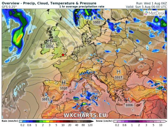
High pressure takes charge during the first few days of September

Outlook: High pressure will eventually build, it’s been trying to do this for a good while. So expect plenty of sunny spells and dry weather. Pleasant daytime temperatures to be had too.

Follow @ChadWeather on Twitter for the very latest forecasts.

Thanks,
Jon

Forecast Issued on Wednesday the 29th of August 2018 at 11:15am.
Image: https://www.netweather.tv/

Thursday 23rd August 2018 – Bank Holiday Monday 27th August 2018

Hi all,

The coats are coming back out and there are only 9 days left of meteorological summer! Autumn is just around the corner! But, will we see another hot spell? I’m sure we will, but perhaps not until late-September or even an Indian Summer will lead to our last BBQ of 2018!

Thursday:  A cooler airmass has replaced the muggy and humid air that was in place earlier in the week. Bright spells and some blustery showers, especially later. Feeling much cooler. Max 17°C

Friday:  A northwesterly breeze feeding in some heavy showers, with a risk of hail or thunder and lightning. These most frequent into the afternoon and evening. Windy and feeling cold. Max 14°C

Chilly Nights

Some chilly nights this weekend as temperatures take a dip

Weekend: Not too bad but temperatures below average.

Saturday: Any early morning showery rain clears, skies will brighten and a lot of sunny spells will develop and remaining dry. A fresh feel and breezy. A cold night to follow as skies clear. Max 17°C

Sunday: Looks dry with variable amounts of cloud with bright or sunny spells. Rain overnight. Max 17°C

Bank Holiday Monday: Patchy rain or showers moving from west to east. Brighter later. Max 18°C

Outlook: High pressure building from the southwest. Dry with sunny spells and warmer with temperatures eventually back into the 20s (just).

Follow @ChadWeather on Twitter for the very latest forecasts.

Thanks,
Jon

Forecast Issued on Wednesday the 22nd of August 2018 at 1pm.
Image: https://www.netweather.tv/

Thursday 16th August 2018 – Sunday 19th August 2018

Hi all,

Where has summer gone? Will the heat and sunshine return anytime soon? Only 17 days until Autumn is here.

Thursday:  Any early rain will clear to much brighter skies but breezy and feeling fresher as winds swing to a west-northwesterly. It should be mostly dry with sunny spells and just the odd scattered shower, so all-in-all not a bad day at all. Max 18°C

Friday:  Mostly dry and cloudy with a brisk south-west breeze. Some showery rain late-evening and overnight. Max 18°C

Weekend: Mostly cloudy, muggy and breezy with rain on Sunday.

Saturday: Some sunny spells but again the focus is more on cloudy skies and breezy. Feeling slightly warmer and a bit muggy. Max 20°C

Sunday:  Cloudy with rain at times slowly easing later in the day. Breezy. Max 20°C

Outlook: Very little change until midweek when hopefully (didn’t happen this week), high pressure will build in from the southwest bringing more in the way of sunshine and temperatures just into the 20s but it might only last a few days. The wait for another heatwave and clear blue skies continues. The next one could well be an Indian Summer.

HIGH PRESSURE

Perhaps high pressure will be more in control towards the end of the month

Follow @ChadWeather on Twitter for the very latest forecasts.

Thanks,
Jon

Forecast Issued on Wednesday the 15th of August 2018 at 2pm.
Image: http://wxcharts.eu

Thursday 9th August 2018 – Sunday 12th August 2018

Hi all,

Make the most of Thursday’s sunshine, as the weather will turn unsettled with some more welcome rain this weekend. On the bright side, the outlook is promising.

Thursday: A decent day with plenty of sunny spells. Dry throughout and UV levels still quite high so don’t forget sun-cream. Max 20°C

Friday: Bright spells with heavy and possibly thundery showers, which will ease towards evening. Cooler. Max 17°C

Weekend: Dry and bright start then unsettled.

Weekend

Low pressure in charge this weekend bringing rain or showers

Saturday: The morning should be dry with sunny spells. Becoming breezy from lunchtime with cloud thickening to bring some rain into the afternoon, or if we are lucky, not until the evening. A little humid. Max 19°C

Sunday: Humid and quite warm despite the mostly cloudy skies. Some rain at first which should become showery and ease away into the late-afternoon. Max 22°C

Outlook: Showery rain at first, but from midweek the weather should settle down, with high pressure building from the south-west. Temperatures around 19-21°C.

Follow @ChadWeather on Twitter for the very latest forecasts.

Thanks,
Jon

Forecast Issued on Wednesday the 8th of August at 1:30pm
Image: http://wxcharts.eu

Thursday 2nd August 2018 – Sunday 5th August 2018

Hi all,

July has been another decent summer month, warmer and much drier than average. Recently we’ve had some welcome rain and now there are signs that the very warm to hot weather will return.

Thursday: Any sunny spells to start will fade and cloud increasing with a chance of a few showers. Very warm and a little humid. Max 24°C

Friday: A cloudy morning with perhaps a few spots of rain. Cloud breaking into the afternoon with some bright spells breaking through. Feeling hot in any sunshine. Max 24°C

Weekend: Settled, very warm to hot.

High pressure builds

High pressure builds this weekend but it is Southern England that gets another heatwave

Saturday: A pleasant day. Sunny spells, mainly dry and again temperatures well above average. Max 24°C

Sunday: Hot with sunny spells with a risk of an isolated shower which could be thundery. Max 25°C

Outlook: High pressure in charge but its position is crucial depending on how warm/hot we get. I’m expecting the week to start with temperatures into the mid-20s in a few spots, then cooler air will arrive during the week with temperatures remaining in the early-20s.

July 2018 Stats

Max 28.4°C (26th)
Min 10.3°C (25th)
Av. 18.2°C
Wettest 18.0mm (29th)
Windiest 34mph
Rain 44.2mm (55% of average)
Rain Days 11
Dry Days 20

UV levels are still high so don’t forget sun-cream!

Follow @ChadWeather on Twitter for the very latest forecasts.

Thanks,
Jon

Forecast Issued on Wednesday the 1st of August at 2:45pm
Image: http://wxcharts.eu