Thursday 1st February 2018 – Sunday 4th February 2018

Hi all,

January is coming to a close and with just a month left of winter, who’s looking forward to Spring and those lighter mornings and evenings? I know I am, but I’m still hoping for some more snow before we get there.

Thursday: Cold with bright or sunny spells and windy. Just the chance of an isolated wintry shower during the morning mainly in western areas. Max 5°C

Friday: A cold and frosty start then a reasonable day with sunny spells and a chilly wind. Cloudier later in the day. Max 5°C

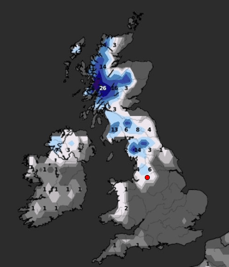
Weekend: Chance of snow

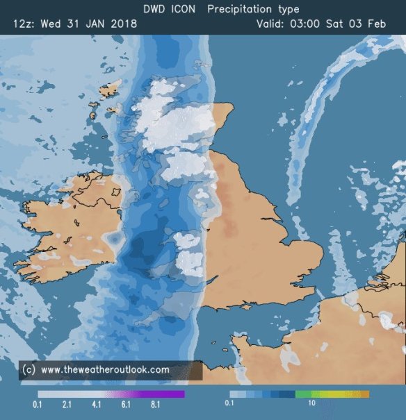
Rain arriving from the west on Saturday could turn to snow

Saturday: A very cold day. Cloudy with rain pushing in from the west. Snow is possible on higher ground (mostly >200M) but not exclusively. So, with a chance of snow to lower-levels, watch out for updates on Twitter. Later into the evening we return to a few wintry showers. Max 3°C

Sunday: A return to the brighter weather with a cold wind and sunny spells. The odd wintry shower possible in eastern areas. Max 5°C

Outlook: Remaining cold throughout with bright spells, slight frosts and some wintry showers. Tuesday/Wednesday could see a band of rain which could turn to snow in places. One to watch.

Follow @ChadWeather on Twitter for the latest forecasts.

Thanks,
Jon

Forecast Issued: Wednesday the 31st of January 2018 at 7:15pm
Image: www.theweatheroutlook.com

Thursday 25th January 2018 – Sunday 28th January 2018

Hi all,

It’s back to the normal British winter. No snow or proper cold in the next 7 days.

Thursday: A few bright spells during the morning but some showers, perhaps heavy and thundery, will arrive into the afternoon and last into the evening. Max 8°C

Friday: A reasonable day. Light winds, some sunny spells and mostly places escaping with a dry day. A touch cooler. Max 7°C

Weekend: Milder with some rain.

Saturday: A dry start but cloud thickening with some outbreaks of rain and drizzle, especially on higher ground, arriving from the southwest. Turning milder. Max 10°C

Mild

Perhaps a 13°C in some spots on Sunday

Sunday: Cloudy and dull with some patchy light rain and drizzle. Some areas sheltered from the southwesterly wind will remain dry. Much milder with a fresh breeze. Max 12°C

Outlook: A trend towards slightly less mild conditions as we enter February. It looks like we will settle down a touch too, with high pressure close by. No sign of anything particularly cold or snowy but a chance of a few slight frosts.

Follow @ChadWeather on Twitter for the latest forecasts.

Thanks,
Jon

Forecast Issued at 13:15 on Wednesday the 24th of January 2018
Image: http://wxcharts.eu/

Thursday 18th January 2018 – Sunday 21st January 2018

Hi all,

We are halfway through winter and we were reminded this week with snow returning to some parts as well as plenty of hail and some thundersnow. After last week’s dank slow-weather days we are back up and running with plenty to talk about. There is some more snow on the way.

Lightning 160118

Lightning Strikes: Tuesday saw thunder and lightning, giving some of us thundersnow

Thursday: The early hours and early morning will be very windy with 50-55mph gusts across the region as a low pressure moves through. The thinking was that this system would be named but it is now less intense and therefore hasn’t been christened. It will briefly become milder but during the morning winds will die down somewhat and it will become colder again. After all that we will see a day of sunshine and frequent thundery wintry showers which will fall as snow above 200M. Max 5°C

Snow showers on Friday

Wintry showers, including some snow, will be blown in again on Friday

Friday: A colder day and windy with more wintry showers feeding in. Again, these could be thundery with hail and snow. Snow showers expected almost anywhere but especially on higher ground where it is likely to settle. Max 3°C

Snow Depth cm by the end of Friday

Predicted snow depth (cm) by the end of Friday

Weekend: Saturday’s the day!

Saturday: A frosty start with snow-cover in places from yesterday’s showers. However a decent day ahead. Dry with sunny spells and cold. A perfect winter’s day. Max 4°C

Sunday: A cold start and perhaps briefly dry. Rain (timings still uncertain at this stage) will then move in from the west preceeded by snow in places, especially on the hills and Pennines, but all areas seeing it turn to rain as it becomes slowly milder later. A thaw of any remaining lying snow. Max 7°C

Outlook: Temperatures average for the time of year but with our weather favouring coming in from the Atlantic, we can expect some spells of rain at times. Chilly nights with some patchy frost.

Follow @ChadWeather on Twitter for frequent weather updates.

Thanks,
Jon

Forecast issued: 10:15am on Wednesday the 17th of January 2018
Images: https://www.lightningmaps.org and http://wxcharts.eu 

Thursday 11th January 2018 – Sunday 14th January 2018

Hi all,

The average maximum temperature for January is about 6°C. Currently we are below, standing at 3.9°C, but with little snow to show for it. I am pinning my hopes on some snow showers next week and a colder end to January but this is just a [hopeful] ‘thought’ and not a certainty.

Thursday: A foggy start, which could cause travel disruption on roads and at the airports, and some patchy frost too. It will be a cold day with some bright spells developing. Fog could linger in places and where it does it will not get much above freezing. Max 4°C

Friday: Little change with a murky start. A dry day to follow with some bright spells
where the low-cloud lifts but general mostly cloudy. Breezy later. Max 5°C

Weekend: Could be better

Saturday: Cloud thickening from the west with some patchy rain arriving slowly. A dull day all round. Max 6°C

Sunday: Any rain easing away and we will see some bright spells developing, but again more cloudy than bright, so a disappointing weekend overall. A more active weather front looks set to sweep rain across the region later on Sunday evening and overnight leading to a more active pattern. Max 5°C

Outlook: After the rain on Sunday we could well see a set-up of cold north-westerly winds with frequent wintry showers, so some snow possible next week, especially so on higher ground and a cold wind for all.

Follow @ChadWeather on Twitter for frequent updates.

December 2017 Stats

Max 11.1°C (7th)
Min -5.2°C (12th)
Av. 4.2°C (below average)
Wettest 13.6mm
Windiest 38mph
Rain 85.4mm (below average)
Rainy Days 28 (grim!)
Dry Days 3
Air Frosts 11
Snow Falling Days 9
Snow Lying Days 4

Thanks,
Jon

Forecast Issued at 1:30pm on Wednesday the 10th of January 2018

Thursday 4th January 2018 – Sunday 7th January 2018

Hi all,

Happy New Year and all the best for 2018!

I hinted that we would end 2017 with a named-storm and in rolled Storm Dylan to be followed by Storm Eleanor yesterday. The Jet Stream has been in charge of our weather in recent days but it will split this weekend and high pressure will build. A northeasterly flow will develop and we will enter a much colder but drier spell of weather.

Thursday: Cloudy with rain for the morning turning showery into the afternoon as the rain band pushes slowly north. We are still in the mild air so temperatures just above average. Max 8°C

Friday: Cloudy with some showers. There will be a little bit of brightness too and as the day progresses, it will get colder. Max 4°C

Weekend: Dry and colder with a biting wind-chill.

Saturday: Cold and mostly dry with some bright spells and the chance of a wintry shower blown in on a freezing northeasterly wind. Widespread frost overnight. Max 4°C

Sunday: Dry with sunny spells after a frosty start. Less breezy, so a pleasant day to get out and about if you’re wrapped up well. Frost returning at night and if winds fall light enough perhaps some fog. Max 4°C

Outlook: High pressure will face a battle with fronts trying to push in from the Atlantic. It will remain cold with plenty of dry weather. Cloud will increase from the west with a risk of rain, preceded by snow, possibly pushing the high pressure away by midweek. If this happens it would turn milder but there’s a reasonable chance that we get ‘locked in’ to the cold for while. Look out for updates on Twitter.

Follow @ChadWeather on Twitter for your weather forecasts.

Thanks,

Jon

Forecast issued at 3:45pm on Wednesday January 3rd 2018