Thursday 26th July 2018 – Sunday 29th July 2018

Hi all,

We’ve had some rain over the last week but we continue to be drier than average. Although there is some more rain on the way, the outlook doesn’t bring much and very warm weather will continue into August with a few hot spells at times.

Thursday: A hot day with hazy sunny spells. It will remain dry and humid. Max 29°C

Friday:  Possibly dry to start with some sunny spells. Frontal systems will arrive making the air unstable. This will set off some heavy downpours with a risk of some torrential thunderstorms, especially over the Pennines and the east of the region. Not everywhere will see one. Not as hot but still humid. Max 25°C

Weekend: Fresher for all.

Saturday: Any early showers clearing to a fresher day with plenty of sunny spells. Just the chance an afternoon shower might develop over the hills. Max 20°C

Sunday: A  bright start but cloud will increase from the southwest bringing a risk of some showers or spells of patchy rain. This is still not certain so watch out for updates. Max 21°C

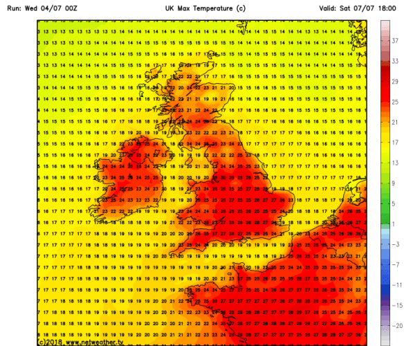
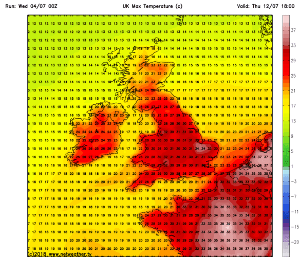
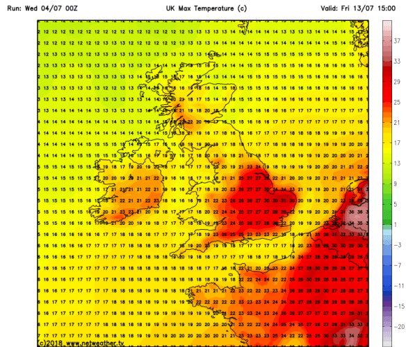
Outlook: Sunny spells and a few showers early next week then perhaps becoming humid and hot again. The chart below shows the heat predicted for the 3rd of August.

HOT HOT FRI 0308

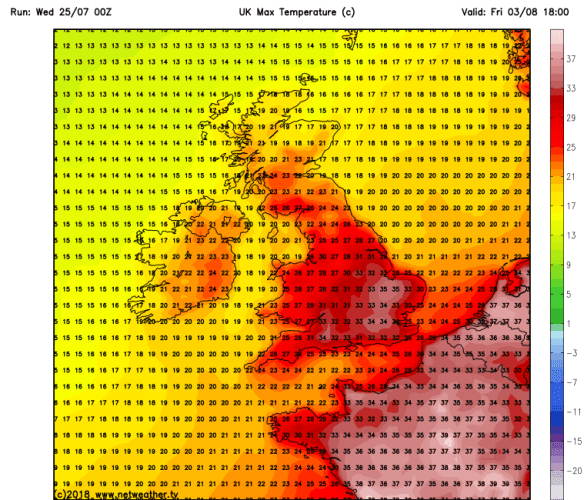
Some high temperatures again as we enter August – 36°C possible down south

Don’t forget sun-cream!

Follow @ChadWeather on Twitter for the latest forecasts.

Forecast Issued: Wednesday, July the 25th at 12:45pm.
Image: https://www.netweather.tv/

Thanks,
Jon

Thursday 19th July 2018 – Sunday 22nd July 2018

Hi all,

We have slipped out of the heatwave but still enjoying some warm to very warm temperatures. Although we’ve had some welcome rain, the weather has been kind with mostly dry conditions and sunny spells.

We have a hosepipe ban on the horizon and it doesn’t surprise me with the heatwave, lack of rain and wildfires. In fact, looking at the statistics, out of the last 11 completed months, 8 of them have delivered below average rainfall. The months that did deliver above average rainfall, didn’t exactly over do it either. A green arrow indicates rainfall above average. Normally green wouldn’t be the right colour to use but for this it is. Most of the recent months in 2018 have been exceptionally dry.

rainfall stats

Actual rainfall amounts vs. average amounts since August 2017


Thursday: A lovely day. Very warm with sunny spells and mainly dry for all. Max 24°C

Friday: A bright start but soon cloudy with patchy rain moving southeast across the region into the afternoon with perhaps some heavier bursts. It should turn drier during the evening after a few showers. Max 20°C

Weekend: Very warm, humid and bright.

Saturday: Quite cloudy at first but bright spells will break through. Feeling warm. Just a low chance of a shower. Max 22°C

Sunday: Bright or sunny spells and dry. Warmer. Max 24°C

Outlook: Hot early next week with temperatures in the mid-20s or just above. During the week there is a risk of a few showers breaking out but not a lot of rain on the way. Small chance of us picking up a southerly airflow bringing hotter conditions, one to watch.

Don’t forget sun-cream!

Follow @ChadWeather on Twitter for the latest forecasts.

Forecast Issued: Wednesday, July the 18th at 2:15pm.

Thanks,
Jon

Thursday 12th July 2018 – Sunday 15th July 2018

Hi all,

In general, the heatwave has continued across the UK over the last week, albeit with some less hot temperatures at times. We have also seen some more in the way of cloud but none of the much-needed rain. The last significant rain, 5.2mm, was on Saturday the 16th of June. We did have a few days after that with some early-morning drizzle and in fact the last day of measurable rainfall was on the 21st of June. Today marks the 20th day (assuming we don’t sneak an evening shower) without rain, beating the previous 19-day record set back in March 2013. But, could we finally see some rain later this week?

Thursday: Very warm with sunny spells. Becoming a bit more humid than recently and as the air turns a little more unstable, cloud will bubble up and there is a good chance of a beefy shower or two. Max 24°C

Friday: Humid with an increased risk of hefty showers or thunderstorms developing, catch one and it will be a very welcome torrential downpour. Sunny spells and feeling hot again. Max 25°C

Weekend: Hot and humid.

Saturday: Hot with sunny spells. Still the chance of an isolated downpour or thunderstorm but the risk will be significantly lower than yesterday. Breezy later. Max 26°C

Sunday: A band of cloud will push down from the northwest in the early hours. There could be some rain on it but it will be patchy in nature. This will soon fizzle out to bring sunny spells and hot and humid conditions. Max 27°C

Outlook: Ex-Hurricane Chris mixed in with the Jet Stream could mean we see a return to westerly winds and some showery rain, but this is very uncertain. There is a good chance it will bring this change to Scotland and Northern Ireland but we continue to be warm to very warm with conditions remaining mostly dry. Not good news as everywhere is parched. So in summary, next week seems to be bright or sunny spells with a few showers here and there and staying warm with temperatures in the 20s. Something to note is; there is a small chance that Chris darts south and in turn we import some very hot air from Spain, a Spanish Plume perhaps, so watch out for updates.

Don’t forget sun-cream!

Follow @ChadWeather on Twitter for the latest forecasts.

Forecast Issued: Wednesday, July the 11th at 2:15pm.

Thanks,
Jon

Thursday 5th July 2018 – Sunday 8th July 2018

Hi all,

I hope you’re making the most of the ‘unusual’ Summer weather that we are having. Normally we manage a decent week in May, then September, but we are experiencing a heatwave that’s set to continue. That said, we are now needing rain more than ever. Something I never thought I would say and I can’t see any on the horizon.

In May we only had 56% of the average rainfall. In June only 19%. The lack of rain combined with the heat and low humidity contributed towards the Saddleworth Moor and Winter Hill wildfires.

Thursday: Perhaps cloudy to start in some areas but this will thin to bring another very warm day with sunny spells. Max 24°C

Friday: Sunny spells and very warm. Lighter winds as a new area of high pressure builds across the UK. Max 23°C

Weekend: Becoming hotter.

Saturday temps

Weekend temperatures back up close to 30°C

Saturday: Hot with plenty of sunshine. Warm and muggy overnight. Max 28°C

Sunday: More summer sunshine and hot. Light winds throughout the weekend will not offer any relief and somewhere might see 30°C. Max 29°C

Thursday temp 12th

Remaining hot next week: Thursday could see temps close to 35°C in parts of the UK

Outlook: No change looking at Monday (9th) to Thursday (12th), hot with plenty of sunshine and temperatures could exceed 30°C as well as it feeling huimd. No rain expected during this period. Perhaps a little less hot by Friday.

Friday 13th

But do we finally see some cooler air arriving during Friday (13th) – one to watch

UV levels HIGH at 7-8 during the whole of the forecast period so don’t forget sun-cream.

Follow @ChadWeather on Twitter for updates.

June 2018 Stats

Max 28.1°C (26th)
Min 7.8°C (24th)
Av. 15.7°C
Wettest 5.2mm (16th)
Windiest 43mph
Rain 14.8mm
Rainy Days 10
Dry Days 20

Av. Max Temp should be 17.8°C we achieved 20.2°C.

Thanks,
Jon

Forecast Issued on Wednesday the 4th of July at 10:30am
Images: https://www.netweather.tv