Thursday 19th October 2017 – Sunday 22nd October 2017

Hi all,

Autumn continues to live up to its name as we experienced some wild weather earlier this week. Ex-Hurricane Ophelia (Bizarre Storm) arrived as forecast but we escaped the worst. Chadderton recorded a 44mph gust but generally across the region it was 50-55mph with 70mph along the coast. What was unusual was it wasn’t hammering down with rain. Once morning-showers moved away, some lightning was recorded near Bury, then the day turned very strange indeed. I had noticed a weird ‘light’ on the way to work and soon the sky was filled with rolling cloud that looked very smoke-like and a glowing red sun. Ex-Ophelia’s southerly winds had pushed smoke particles from the Portuguese/Spanish wildfires and Saharan Sand northwards (Red Sun Phenomenon).

As you know we have named-storms and we are currently on ‘B’ as we had Aileen in September. The reason Ophelia wasn’t Brian was because she was already named and since she kept her strength, she remained named the same, even though an ex-Hurricane, as she arrived on our shores.

Storm Brian could well be here quicker than you think……

Thursday: A lot of cloud around but with some bright spells during the day after a misty start. With light winds it will feel pleasant and mild. However, the breeze will pick up later in the day with a risk of some showery rain developing especially to the south and east. Max 16°C

Friday: Fronts will arrive from the west, so a spell of rain which will be followed by brighter conditions and some showers. Breezy and fresher. Max 13°C

Weekend: Poor. Wet and very windy.
Brian

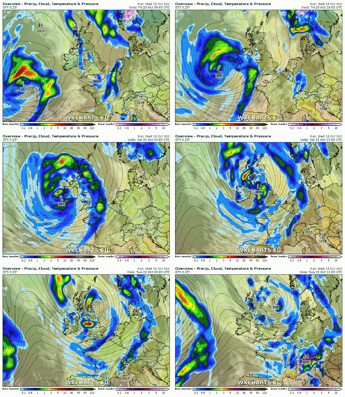
Storm Brian this weekend?


Saturday: A deep area of low pressure will have been forming out west on the Jet Stream and this system could well be named as Storm Brian. At the moment the strongest winds (70mph gusts) look to be heading to Southern Britain, but the track is still uncertain so watch tweets for updates. Currently, it will be a wet day with rain, heavy at times and windy with 40mph gusts. Feeling cold. Max 13°C

Sunday: The ‘storm’ will move into the North Sea but will introduce cold north-easterly winds and with it frequent showers which could be thundery. Remaining windy with gusts possible to 45mph during showers. Max 12°C

Outlook: Remaining unsettled with some spells of wind and rain broken up by some drier slots. Temperatures around or just above average.

Follow @Chadweather on Twitter to keep up to date with the local weather.

Thanks,
Jon

Forecast Issued: Wednesday the 18th of October 2017 at 1pm
Images: WXCHARTS – Follow them on Twitter.

Thursday 12th October 2017 – Sunday 15th October 2017

Hi all,

I’m back from a superb golfing holiday in Spain. If you missed the photos, the weather was amazing. Four days of 27-30°C and plenty of sunshine. Remind me again why I live in the UK. 😦 At least we will see some warmer air in time for the weekend.

Thursday: After a poor Wednesday, a much better day with plenty of sunny spells after a chilly start. Cloud will bubble up during the day but it will remain dry with lighter winds. Fresher. Max 15°C

Friday: That warmer air mass starts to arrive but with it rain at times on a keen southwesterly wind. There will be some drier slots. Muggy. Max 18°C

Weekend: Warm and not too much rain about.

Saturday: Generally cloudy with a risk of drizzle or light rain on coasts and hills to start. Hilltops could be misty or covered in low-cloud. As the day progresses it should dry up with some localised brightness and feeling warm for the time of year. Max 19°C

Sunday: Drier with bright spells at times. Still feeling warm with southerly winds especially in any sunshine. I have lots of BBQ food left…… hmmmmm. Max 19°C

Warmer 2

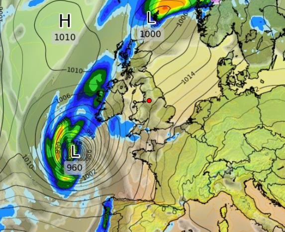
Ex-Hurricance Ophelia located to our southwest

Warmer 1

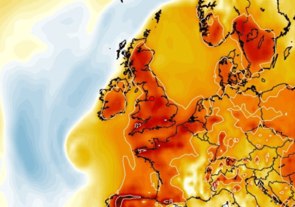
Above average temps: Warmer air ahead of ex-Hurricane Ophelia, cooler air behind it

Outlook: The remnants of Hurricane Ophelia, located to the southwest of the UK, may bring further warm air up from the south on Monday. With sunny spells on offer, temperatures could be close to 21°C. The rest of the coming days will be cooler and mostly cloudy before rain and wind returns.

Follow @ChadWeather on Twitter for the latest forecasts.

Thanks,
Jon

Forecast Issued at 6pm on Wednesday the 11th of October 2017

Thursday 5th October 2017 – Sunday 8th October 2017

Hi all,

A quick blog this week as I pack my bags for a 4-day golfing holiday in Spain and before you ask, yep, hot and sunny is my forecast :). But, what about back home. We’re now into October and autumn is certainly being felt with temperatures slipping back into the early teens and this trend is set to continue with some chilly nights on the way.

Thursday: Windy with rain at times during Wednesday night (see warning); this will clear quickly during the morning, turning drier with sunny spells and just the odd shower. Feeling cool in the keen northwesterly wind. Max 13°C

Friday: High pressure over the UK meaning a settled day with sunny spells, but it will be a cold start, with some ground-frost. It will be mostly dry,  just the chance a shower will drift down on the fresh northwesterly wind. Cold overnight again with a touch of ground-frost in rural spots before it turns cloudier. Max 13°C

Weekend: High pressure replaced by low pressure again.

Saturday: Any early brightness fading sharpish with cloud and rain spreading in from the west as the day progresses. Windy and miserable. Max 14°C

Sunday: Remaining generally cloudy with a few showers and perhaps some bright spells into the afternoon. Max 15°C

Outlook: Changeable with some days dry and bright, but others unsettled, especially later on, with spells of showery rain and wind. Remaining cool with some overnight ground-frosts and fog under any clear skies. No sign of an Indian Summer.

September 2017 Stats What a poor month

Max 20.2°C
Min 3.6°C
Av. 12.6°C
Wettest 15.6mm
Windiest 33mph
Rain 99.2mm
Rainy Days 26
Dry Days 4

Follow @ChadWeather on Twitter for the latest forecasts.

Thanks,
Jon

Forecast Issued at 12:30pm on Wednesday the 4th of October 2017