Thursday 29th September 2016 – Sunday 2nd October 2016

Hi all,

We are now into Autumn and it will certainly feel cooler at times over the next few days. Got any weekend plans? Sunday’s looking the ‘outdoor day’.

Thursday: Sunny spells and some scattered showers. Catch one and it could be heavy. Much fresher than Wednesday and windy. Max 16°C

Friday: Bright spells and showers. Showers heavier and more frequent than yesterday. Still breezy but it shouldn’t be as windy. Feeling cool. Max 14°C

chilly-night

A cold night on Saturday could see a rural ground frost

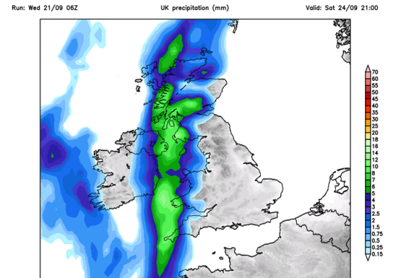
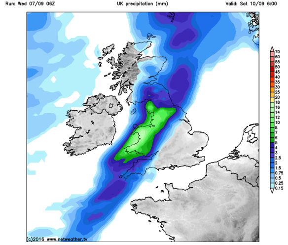
Saturday: We are still likely to see some rain as low pressure swings across England and Wales. Lighter winds and the rain should clear by evening and it will be a cold night with clear spells developing. Rurally a ground frost. Max 13°C

Sunday: The best day of the weekend. It promises to be dry with plenty of sunny spells after a cold and possible misty or foggy start. Max 14°C

temps-up

The back-end of next week could see warmer temperatures again

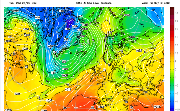
Looking ahead: A southerly airflow should lift the temperatures early next week with some rain arriving on Tuesday. After that it’s back to cooler conditions before possibly warming up again by the end of the week where we could approach 20°C.

As always, our weather is ever-changing. Keep up-to-date with what’s in store by following my tweets via @ChadWeather on Twitter.

Thanks,
Jon

Forecast issued at 1:50pm on Wednesday 28th September 2016
Images: http://www.netweather.tv

Thursday 22nd September 2016 – Sunday 25th September 2016

Hi all,

After last week’s storms and high temperatures, it’s been a quieter week so far. This pattern will continue until the weekend. It’s a short and sweet blog this week as I head off to Spain today for 4 days of golf and hot sunshine (so @MeteoGib promises me) :).

Thursday: It will start cloudy, on Autumn Equinox Day, with some patchy rain and mild. This rain will clear to leave a day of sunny spells and quite pleasant. Max 16°C

Friday: High pressure sitting to our south. Bright or sunny spells. Becoming breezy later with a risk of a shower or two. Max 18°C

The Atlantic starts to influence over the weekend.

rain

Rain expected later on Saturday – likely late-evening

Saturday: A dry start with any brightness fading as cloud thickens from the west. It will become windy and rain, some heavy, is expected later in the day. Hopefully, it will hold off until after dark or even overnight. Feeling a little muggy. Max 19°C

Sunday: Once Saturday’s rain clears we will be left with sunshine and showers, some of these could be heavy or thundery. Still breezy and fresher. Max 16°C

Next Week: Details uncertain as the Jet Stream kicks in. Some cool nights where we have light winds and clear skies. By day, some spells of rain with drier intervals. Temperatures around average, maybe above on a few occasions.

As always, our weather is ever-changing. Keep up-to-date with what’s in store by following my tweets via @ChadWeather on Twitter.

Thanks,
Jon

Forecast issued at 12:25pm on Wednesday 21st September 2016
Images: http://www.netweather.tv

Thursday 15th September 2016 – Sunday 18th September 2016

Hi all,

Well, after waiting all summer for a decent storm, one finally arrived nearly two weeks into September and wasn’t it a belter. Torrential rain, continuous lightning and roaring thunder. My kind of heaven but with localised flooding someone’s kind of hell. At Chaddy HQ the storm dropped 16.8mm in an hour. The wettest area around Bramhall saw 30-35mm of rain fall. That’s about half a month’s worth. During the torrential downpour we also managed an impressive rain-rate of 145.8mm/hr. As the storms moved through the region the whole cell produced over 10,500 lightning strikes. So, any more storms to come?

img_4481

Over 10,500 lightning strikes were recorded

Thursday: I am expecting a cloudy and misty start in some places. This will be slow to burn off especially towards the hills. Eventually it will be a day of sunny spells and again very warm for September and feeling so with lighter winds than Wednesday. Max 24°C.

storm-risk

A widespread storm risk later on Thursday and overnight

Thursday (overnight): From late-evening on Thursday we have a warning in place for more storms. These storms will develop to our south, move north then away to the east. The timing or certainty is very tricky. So be aware of possible thunderstorms in the early hours and don’t be surprised to hear a rumble or two.

cooler-air-arriving-on-friday

Fresher and cooler air arrives from the Atlantic on Friday

Friday: All change. Any morning storms, cloud and rain clearing. A much brighter afternoon with sunny spells and breezy. What will be noticeable will be how much fresher and cooler it will feel as northwesterly winds arrive. Just a chance of a shower later on. Max 17°C.

Saturday: Looking reasonable. Mainly dry with sunny spells. Temperatures around normal. Max 17°C.

Sunday: Bright spells for the morning. Cloud thickening with rain likely to arrive into the afternoon. Max 17°C.

cooler-overnight

After the recent warmth; some chilly nights expected next week

Next Week: Bright spells and some showers by day. A little cool compared to recently and overnight temperatures likely to slip into single-figures.

As always, our weather is ever-changing. Keep up-to-date with what’s in store by following my tweets via @ChadWeather on Twitter.

Thanks,
Jon

Forecast issued at 8:10pm on Wednesday 14th September 2016
Images: http://www.netweather.tv and en.blitzortung.org

Thursday 8th September 2016 – Sunday 11th September 2016

Hi all,

Autumn is here but it’s been a muggy week, so what’s in the forecast for the next four days.

Thursday: A very mild start and any brightness will be replaced by cloud and some localised patchy rain. This is a cold front so once it clears the afternoon will be brighter with sunny spells. It will then be fresher and cooler. Max 19°C

Friday: Breezy with sunny spells. With south-westerly winds it will still be warm. Heavy showers are likely just about anywhere from the afternoon onwards. Max 20°C

sat-rain-am

A spell of rain to start Saturday

Saturday: Cloudy with rain during the morning with some heavy bursts. A brighter and sunnier afternoon is expected as the rain clears and a little ridge of high pressure builds in. Cooler and breezy. Max 17°C

Sunday: Bright spells and breezy with the wind picking up during the day. Some showery rain likely to come in from the west later in the evening. Max 18°C

Looking ahead: Quite breezy with sunshine and some showers. I can’t see anything significantly warm or wet on the horizon. I wonder when our first cold spell will arrive and with it, our first frost.

As always, our weather is ever-changing. Keep up-to-date with what’s in store by following my tweets via @ChadWeather on Twitter.

August 2016 Stats

Av. Temp 15.7°C
Max Temp 25.9°C (23rd)
Min Temp 8.5°C (9th)
Wettest Day 21.6mm (22nd)
Highest Gust 40mph (3rd)
Rainfall 81.0mm
Rainy Days 18

Thanks,
Jon

Forecast issued at 2:30pm on Wednesday 7th September 2016
Photo: http://www.netweather.tv