Steamy End to Month – Thursday 30th July 2020 – Sunday 2nd August 2020

Hi all,

July has been particularly poor on the temperature front and not great when it comes to dry weather either, but the month is going to end with some heat and humidity wafting up from Spain.

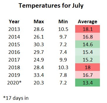
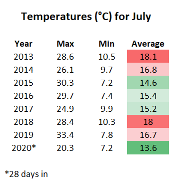
Here’s an updated image of the temperatures statistics for July vs. previous years.

Woeful Temperature Stats for July 2020

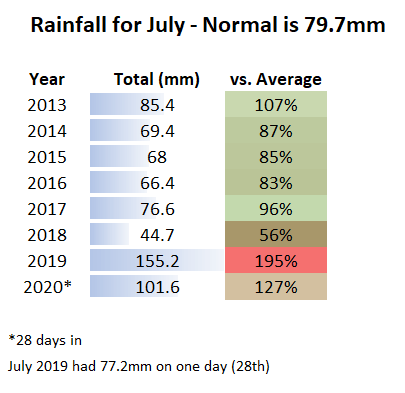
And looking at rainfall…..

July 2020 is wetter than average

**High UV levels still in place so remember sun-cream**

Thursday: Early cloud and a few showers will push north during the morning leaving a day of increasingly sunny skies and much warmer temperatures. Feeling hot and humid by evening. Max 25°C

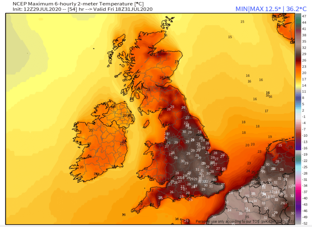
Friday: A hot day with plenty of sunshine. Cloud arrives by evening with a change beginning out west. Only downside is it will be quite breezy at times. Very humid. Max 30°C

A baking day on Friday. Somewhere in the UK could see 35°C – impressive for a short-lived hot spell

Weekend: Cooler but not too bad

Saturday: Cooler weather will arrive from the west and with it some cloud and a few localised showers. Sunny spells developing later and breezy. Max 19°C

Sunday: Sunny spells and most places dry but a few scattered showers can’t be ruled out. Max 19°C

Outlook: Unfortunately, unsettled weather will return.

Follow @ChadWeather on Twitter for the latest weather forecasts.

Thanks,
Jon

Forecast Issued: Wednesday the 29th of July 2020 at 7:25pm.
Image: https://weathermodels.com/

A poor July continues – Thursday 23rd July 2020 – Sunday 26th July 2020

Hi all,

No let-up in this grim summer month. Notably, the temperatures have really struggled. I posted the below on Twitter this week and it’s clear to see how disappointing July has been so far.

Thursday: Cloudy with pulses of showery rain coming in from the west. Quite warm considering. Max 18°C

Friday: If you can, take advantage of a breather from the cloud and rain. A decent day is in store with warm sunny spells. Remember sun-cream as UV levels are still high. Max 19°C

Weekend: Low pressure arrives

Saturday: Rain welcomes the start of the weekend, moving west to east. Bright spells and showers follow. Breezy. Max 18°C

Sunday: Bright spells and scattered showers. Again a little breezy. Max 17°C

Outlook: Changeable with showery rain at times. No sign of anything very warm or hot on the horizon. Sad times.

Follow @ChadWeather on Twitter for the latest forecasts.

Thanks,

Jon

Forecast Issued: Wednesday the 22nd of July 2020 at 4:45pm.

A little warmer with some sunny spells – Thursday 16th July 2020 – Sunday 19th July 2020

Hi all,

Well last week’s weather forecast didn’t go to plan, as high pressure failed to establish itself over the UK for the second weekend running. July is turning out to be a disappointment.

Thursday: A cloudy and generally overcast day throughout but it looks like staying dry, quite humid and warmer with light winds. Chance of some breaks in the cloud later. Max 18°C

Friday: Bright spells developing and feeling pleasant but a little humid. Warmest day of this forecast. Max 21°C

Weekend: Some rain.

Saturday: Any brightness fading as cloud thickens from the northwest. A weakening cold front will bring some patchy rain. Not much rain as the front breaks up as it moves through an area of high pressure. Bright spells later. Max 17°C

Sunday: Brighter with sunny spells. Breezy and fresher for all. Max 18°C

Outlook: Warm at first with some dry weather and sunny spells. From midweek, it looks like high pressure will slip away as low pressure closes in on Scotland. In between we will become breezy and mostly cloudy with a risk of some rain at times.

Follow @ChadWeather on Twitter for the latest forecasts.

Thanks for reading. Stay Safe!
Jon

Forecast Issued: Wednesday the 15th of July 2020 at 5:30pm.

Drier and Warmer Weather to return but for how long – Thursday 9th July 2020 – Sunday 12th July 2020

Hi all,

The weather is certainly misbehaving and we are definitely suffering now after enjoying a lovely April and May. But, there is some hope on the horizon.

Thursday: Cloudy with light rain or showers continuing for most of the morning. Slowly drier into the afternoon. Max 16°C

Friday: Sunny spells and a heavy shower or two developing, especially so in the east. Max 16°C

Weekend: At last. Much improved compared to recent weekends. Light winds.

Saturday: High pressure is set to build across the UK from the southwest. So the weather will become settled with light winds and bright spells developing but some of us could keep some stubborn cloud. Cool overnight. Max 17°C

Sunday: Sunny spells here and there and feeling warmer after a fresh start. Max 20°C

⚠️ UV levels still high so wear sun-cream.

Outlook: Quite hopeful that high pressure will stay in charge for a few days of the week ahead; so some warm bright/sunny spells and temperatures into the 20s. Question mark over midweek as to whether the high pressure slips back away to the southwest and thicker cloud topples in from the northwest or not.

Follow @ChadWeather on Twitter for the latest forecasts.

As ever, thanks for reading. Stay Safe!

Thanks,

Jon

Forecast Issued: Wednesday 8th July 2020 at 4:20pm

Unsettled then improving next week – Thursday 2nd July 2020 – Sunday 5th July 2020

Hi all,

Meh. June might have had a brief ‘heatwave’ and reached 30°C but it delivered a lot of rain, 170% of the monthly average, mostly coming from thundery downpours, and overall was disappointing. Here’s July and although it’s a new month, there’s little change in our weather for now…..

As always at this time of the year when sunny – HIGH UV LEVELS – Wear sun-cream.

Thursday: Rain to start, pushing away to the south and turning showery. Bright spells later and drier towards evening. Max 18°C

Friday: Cloud thickening throughout the day with rain slowly spreading in, with some heavy bursts. Becoming windy with extensive hill-fog. Max 16°C

Weekend: Still unsettled.

Low pressure drives the weekend weather

Saturday: A band of rain moving southeast to be replaced by a few showers and the odd bright spell. Breezy. Max 17°C

Sunday: A windy day with scattered showers and some bright or sunny spells in between. Max 18°C

Outlook: It looks like high pressure will slowly edge in from the southwest (just) settling the weather down. So drier and brighter with sunny spells breaking out as the week progresses. Temperatures a little disappointing at first but then recovering to around 20°C towards the end of the week. With areas of rain to the northwest we might see some breezy days but we will live with that after recent conditions.

June 2020 Stats

Max 30.0°C (25th)
Min 6.3°C (5th)
Av. 14.6°C
Av. Dew Pt 10.3°C
Wettest 39.8mm (16th)
Av. Humidity 77%
Av. Barometer 1012.7 hPa
Max Gust 39.1mph
Av. Wind Direction WSW
Rain 132.6mm
Rain Registered Days 19
Dry Days 11

Follow @ChadWeather on Twitter to keep up with the latest weather forecasts.

Thanks,
Jon

Forecast Issued: Wednesday the 1st of July 2020 at 7:40pm
Image: https://www.wxcharts.com/