Thursday 28th September 2017 – Sunday 1st October 2017

Hi all,

After a mostly wet September the last third hasn’t be too bad with mild temperatures and drier conditions. It looks like the Jet Stream returns into October bringing more rain and also some windier conditions which could lead to Storm Brian.

Thursday: Early rain will clear to leave a reasonable day with sunny spells and it should remain dry. Max 17°C

Friday: Cloudy with another band of rain spreading west to east. It will clear into the afternoon with the odd shower to follow. Cooler. Max 16°C

Weekend: Saturday the better day of the two.

Saturday: Sunny spells and perhaps the odd shower. Feeling fresh. Max 15°C

Sunday: Rain, heavy at times arriving from the west and lasting most of the day. Looks like my golf competition could be a washout. Meh. Max 14°C

Outlook: Ex-hurricanes Maria and Lee, will influence our weather. It’s uncertain yet, after a spell of wind and rain (perhaps a named-storm), whether it settles down or remains wet. Time will tell as currently it could go either way.

One thing to note: the media and tabloids will have a field day but the predicted wet and windy weather for early October is nothing unusual as we tend to have our fair share of Autumnal storms.

Follow @ChadWeather for the latest weather forecasts.

Thanks,

Jon

Forecast issued on Wednesday the 27th of September 2017 at 6:15pm.

Thursday 21st September 2017 – Sunday 24th September 2017

Hi all,

It’s been quite warm today which followed a day that started with a ground frost. September, the month of contrasts. A lot of media hype again about Indian Summer etc. but it’s just clickbait at the moment so don’t rise to it.

Thursday: Some will start dry but soon heavy rain will move in from the west. This will slowly move east allowing the rain to turn patchy and eventually ease away into the evening. Max 15°C

Friday: Bright spells for the morning but again cloud will thicken with rain arriving into the afternoon and evening. Max 16°C

Weekend: Saturday looks the best, warm and bright.

Saturday: With winds from the south it will be quite a warm day but increasingly breezy. Bright spells and dry. Max 18°C

Sunday: Mostly cloudy and any morning brightness likely not to last with some drizzle possible into the afternoon. Most places staying dry. Max 17°C

Outlook: It’s looking quiet with a lot of cloud but the potential to remain dry for several days. Temperatures around or just above average.

Follow @ChadWeather on Twitter for the very latest weather updates.

Thanks,

Jon

Forecast Issued at 19:50 on Wednesday the 20th of September 2017

Thursday 14th September 2017 – Sunday 17th September 2017

Hi all,

Storm Aileen, our first named-storm of the season, certainly had the potential to deliver some strong gusts in excess of 60mph during the early hours of Wednesday, but failed to deliver. The track of the low was crucial and the path taken meant the stronger winds were located further south and southeast. I only recorded 33mph at 2:53am. The lowest pressure recorded was at 2:21am with a value of 984.19mb. Nothing unusual at all for Autumn.

Here’s the A-Z of named-storms from the Met Office.

Thursday: A day of sunshine and occasional showers which will arrive on a fresh, cool north-westerly wind. The showers should ease towards evening. Max 15°C

Friday: Little change with bright spells and showers. The breeze will be from the north so a chilly feel. Clear spells will lead to temperatures dipping into single figures. Max 14°C

Weekend: Improving slowly. Cool nights. 

Saturday: Plenty of cloud around with some bright spells. Some showers still likely, especially so in eastern areas. Max 15°C

Sunday: A cold start with perhaps a rural ground frost. Sunny spells developing and we should have killed off the showers so remaining dry. Max 15°C

Outlook: Not a bad start to next week. Dry with bright spells but showers are expected to return from midweek.

Follow @ChadWeather on Twitter for the latest forecasts across Manchester and its surrounding areas.

Thanks,
Jon 

Image: Met Office

Forecast Issued at 13:40 on Wednesday the 13th of September 2017

Thursday 7th September 2017 – Sunday 10th September 2017

Hi all,

Summer has been and gone (meteorologically speaking of course). Did anyone see it arrive? I remember June being quite settled late on and quite warm which ran on a little into July. August was very disappointing and the coolest summer month.

Av. Max. Temps

June 18.2°C
July 19.0°C
August 17.8°C

Av. Temps

June 15.0°C
July 15.4°C
August 14.5°C

Thursday: Bright spells, but with the general theme of cloud thickening during the day and the breeze will pick up. Rain arriving during the afternoon. Max 17°C

Friday: A lively day with plenty of showers, maybe thundery, and windy. Feeling cooler. Max 14°C

Weekend: Cool, showery and feeling autumnal.

Saturday: A breezy day with showers feeding in on a northwesterly wind. Cool. Max 14°C

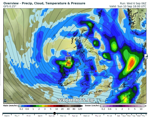
Sunday: Showers will continue but with it some bright spells. Little change in the feel to the weather. Becoming windy into Monday. Max 15°C

Late Sunday

An unsettled weekend ending with the wind picking up & another low pressure

Outlook: Remaining unsettled with low pressure in charge bringing spells of rain or showers. Just a glimpse of something drier towards the end of next week.

Aug 2017 Stats

Max 22.8°C (shocker)
Min 7.7°C
Wettest 10.4mm
Windiest 32mph
Rain 58.2mm (drier than average)
Rainy Days 20 (grim)
Dry Days 11

Follow @ChadWeather on Twitter for the very latest forecast for your area.

Thanks,
Jon

Forecast Issued at 4:20pm on Wednesday the 6th of September 2017