Temperatures rising – 26th December 2019 – 29th December 2019

Hi all,

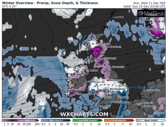
So no White Christmas, which isn’t a surprise, despite what some of the media promise. The chance of us seeing a White Christmas is about 15% and we’re actually more likely to see a White Easter than Christmas, especially when Easter comes early. We were last below zero on the 25th back in 2010, and the last White Christmas was 2009. If you’re a snow- and cold-lover then you’re going to have to be patient.

Thursday: Rain spreading east across the region during the morning. This will ease into the afternoon but it will stay cloudy with some localised drizzle. Breezy. Max 8°C

Friday: Another band of rain swings in and quickly goes through to be followed by a few bright spells and it will be turning milder. Breezy. Max 11°C

Weekend: Very mild but dry

Saturday: High pressure will influence our weather for a few days, dragging in warmer southwesterly winds. Dry with some bright spells. Max 12°C

very mild

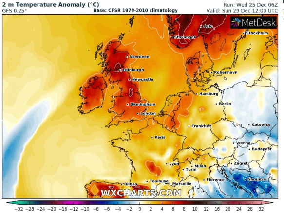
Very mild on Sunday with temperatures 6-8°C above normal

Sunday: Bright spells, breezy, especially to the west, but notably very mild for the time of year. Max 14°C

Outlook: Staying mild and settled with temperatures above average for a few days before rain returns with some very windy spells to start the new year.

I would like to take this opportunity to wish you all a very merry Christmas and all the best for 2020. Thanks so much for all your tweets and kind words throughout the year.

Follow @ChadWeather on Twitter for the very latest weather forecasts.

Thanks,
Jon

Forecast Issued: Wednesday the 25th of December 2019 at 11:50am
Image:
http://wxcharts.eu/

Milder and Unsettled – Thursday 19th December 2019 – Sunday 22nd December 2019

Hi all,

After a few chilly nights, milder air is set to return and with it rain. Cold again in time for Christmas Day?

Thursday: Mild with mostly cloudy skies during the morning. There could be the odd shower too but the main rain is set to arrive later into the afternoon and evening. Max 10°C

Friday: Morning rain clears to mostly cloudy conditions and a few showers, these most frequent in the west. Max 9°C

Weekend: Not bad.

Saturday: Bright spells and a few showers which should ease away during the afternoon. Max 8°C

Sunday: As per the last few days, the heaviest and more prolonged rain will be across southern and eastern England. This means we should be in for a reasonable day with bright or sunny spells and dry, albeit a little cooler. Max 7°C

Outlook: Remaining unsettled with spells of low pressure bringing bands of rain followed by bright spells and showers. Generally a southwesterly airflow, so temperatures slightly above average, meaning a White Christmas is not on the cards, which comes as no surprise.

Christmas Week: Mild and unsettled with low pressure in charge

Christmas Day: Cloudy and mostly dry. Some drizzle developing later. Breezy. Max 8°C

Thanks for reading and I wish you all a very Merry Christmas.

Cheers,
Jon

Forecast Issued: Wednesday the 18th of December 2019 at 12:35pm.

Cold & Unsettled – Thursday 12th December 2019 – Sunday 15th December 2019

Hi all,

It’s certainly feeling like winter now with plenty of rain about and cold, especially so in the wind. I’m getting asked a lot about when the snow is coming, all fuelled by the usual tabloid nonsense, **rolls eyes**. There is some snow potential in this forecast and we take our first look at Christmas Day.

Thursday: Perhaps a slight frost to start with a little brightness. Cloud thickening from the south-west and rain arrives during the day with a short spell of sleet or wet-snow on the tops of the Pennines. Cold. Max 6°C

Friday: Low pressure in charge leading to a showery day but with some bright spells in between. Breezy. Max 6°C

Weekend: Showery and cold.

Saturday: A little cooler with wintry showers and bright spells. Some of the showers falling as hail and above 350M some will be sleety and perhaps in the heavier bursts fall as snow. Max 5°C

Sunday: Breezy and the morning should start bright, especially in the east. Some showers will arrive from the west as the day progresses, again some wintry especially on the hills but this is not set in stone. There will be a band of rain across southern England that could give some snow on its northern edge. At this stage the northern extend of the band seems to be the Midlands but could potentially be further north. Look out for updates on Twitter. Max 6°C

snow midlands

Chance of snow Saturday night into Sunday – all depends on the low’s location

Outlook: Not as windy to start with bright spells and showers and remaining cold. Later in the week we can expect some wet and windy weather to return as low pressure systems come in from the Atlantic and with it some milder spells.

Just for Fun: Current Christmas Day forecast: After a mild Christmas Eve, Christmas Day looks colder with a few wintry showers, a brisk northwesterly breeze and temperatures just slightly below normal. Max 5°C

Follow @ChadWeather on Twitter for the latest results.

Thanks,
Jon

Forecast Issued: Wednesday the 11th of December at 12:25pm
Image: http://wxcharts.eu/

Rain and Mild Conditions Return; Election Day Snow? – Thursday 5th December 2019 – Sunday 8th December 2019

Hi all,

That’s our first winter cold snap out of the way. Didn’t last long but a few sharp frosts under our belt. There are a few rumours knocking around about snow falling on Election Day……

Thursday: A chilly start. Atlantic winds return bringing thickening cloud from the west. Drizzle will develop as the afternoon progresses so a damp end to the day is likely. Milder and windy with 35mph gusts, especially later. Max 10°C

Friday: After a very mild night with temperatures in double-figures, a front will spread some patchy rain southeast. Showery conditions follow and it will turn cooler during the day. Max 11°C

Weekend: Saturday the better day.

Saturday: Dry and bright, then cloud thickening from the west into the afternoon with perhaps the odd shower. The breeze picking up later ahead of heavy rain overnight. Max 9°C

Sunday: Any early rain clearing to a day of blustery showers, some heavy. Windy. Max 10°C

colder from the N

Winds turning north or northwesterly later next week opening the gates to much colder air

Outlook: Monday looks dry with sunny spells, then unsettled again. Turning colder from midweek with a risk of some wintry showers, possibly giving a covering of snow on the hills.

snow depth

UK snow depths by the end of next week

Follow @ChadWeather for the very latest weather forecasts.

Thanks for reading.
Jon

Forecast Issued: Wednesday the 4th of December 2019 at 3:05pm.
Images: http://wxcharts.eu/