Yet more rain on the way – Thursday 26th September 2019 – Sunday 29th September 2019

Hi all,

Rain, rain and more rain. That’s the theme at the moment and this pattern is set to continue for a little while yet.

Thursday:  Rain to start followed by sunshine and showers. Windy. Max 17°C

Friday: The Jet Stream is still across the UK so unsettled with a spell of rain turning showery later. Cooler. Max 15°C

Weekend: Unsettled and possibly very wet on Sunday.

Saturday: Bright spells and showers, some heavy and breezy. Max 16°C

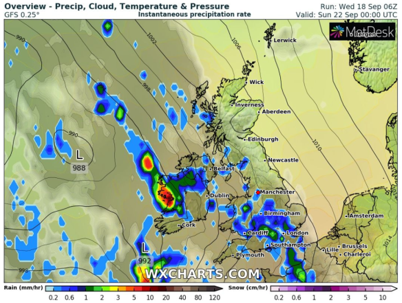
Sunday: Low pressure arriving from the south-west with heavy rain after a dry start. Turning windy and showery later. Max 16°C

Outlook: Drier with some sunny spells and chilly nights as we start October. This is only expected to last a few days before it turns milder and unsettled again.

Follow @ChadWeather on Twitter for the latest updates.

Thanks,
Jon

Forecast Issued at 13:15 on Wednesday the 25th of September 2019.

Enjoy it while you can – Thursday 19th September 2019 – Sunday 22nd September 2019

Hi all,

We’ve quietly slipped into a decent spell of weather. Not quite an Indian Summer (yet!) although temperatures will rise before the weather breaks.

Thursday: A chilly start with some mist or fog patches then plenty of sunshine and feeling warm. Max 17-18°C

Friday: Little change. Sunny spells or even unbroken sunshine after a cold start. Temperatures creeping up so feeling warmer but it will become windy later. Max 20-21°C

Weekend: Very warm and windy then the breakdown.

Weather breaks on Sunday

Enjoy Saturday as it’s a different story on Sunday

Saturday: Another lovely Autumnal day. Blue skies and sunny spells but the only downside is the wind. As the high pressure starts to drift away to the Continent it will become gusty with 30-35 mph likely, especially over the hills. Great temperatures for the time of year. There will be showers arriving late in the evening or overnight. Max 21-23°C

Sunday: I hope you had your BBQ yesterday. Breezy with frequent showers arriving from the west, some thundery. Feeling cooler especially later in the day. Max 18°C

Wet and Windy next week

Next Week: Unsettled and very Autumnal

Outlook: Unsettled, windy (perhaps stormy in parts of the UK) with rain or showers at times. Temperatures back to normal, mid- to late-teens. There could well be the first named-storm of the Autumn.

Follow @ChadWeather on Twitter for the latest weather forecasts for Northwest England.

Thanks,
Jon

Forecast Issued: Wednesday the 18th of September 2019 at 12:30pm.
Images: https://www.wxcharts.com

Becoming warmer, sunnier and dry – Thursday 12th September 2019 – Sunday 15th September 2019

Hi all,

Our weather has been unsettled for a while now and with the remnants of ex-Hurricane Dorian bringing a wet and windy Wednesday morning, then ex-Tropical Storm Gabrielle on the way for Thursday, there will be little change over the 48 hours. BUT, high pressure is on the way and we have a much improved-weekend to look forward to.

Thursday: A bright start soon fading as cloud and patchy rain comes in from the west. A warm sector will bring some tropical air, so feeling humid and warm out there despite the conditions. Max 19°C

Thursday Dew Points

A brief spell of humid air on Thursday as dew points reach 14-15°C

Friday: High pressure arrives so a different day than recently. Plenty of dry weather with sunny spells. Feeling pleasant and less humid. Max 17°C

Weekend: Splendid.

Sunday's TEMP

Feeling much warmer this weekend – temperatures around 19-21°C

Saturday: A misty and chilly start, which will lift then a day of sunny spells and dry weather. Some fair-weather cloud at times and feeling warm in light winds. Max 18°C

Sunday: Some mist patches then sunny spells and warm. Light winds. Max 20°C

Next 10 days Rain

Total Rainfall to the 21st : Rain confined to the NW of the UK; little rain for us

Outlook: High pressure remains. Lots of dry weather. Very little rain over the coming 7 days. Variable cloud with sunny spells. Some mist and fog in the mornings. Temperatures 17-19°C.

Follow @ChadWeather on Twitter for the latest forecasts.

Thanks,
Jon

Forecast Issued: Wednesday 11th of September 2019 at 10am
Images: www.wxcharts.com & www.netweather.tv

Drier for the Weekend – Thursday 5th September 2019 – Sunday 8th September 2019

Hi all,

Autumn is here and Summer has gone as if it never really arrived. I’m looking forward to the cooler days now and before you know it, the talk will be of frost and then snow. The Jet Stream is pretty much in control over the next day or so with some cooler air filtering down from the northwest at times; but improvements are there for the weekend.

Thursday: Sunny spells and windy with some showers developing late-morning and into the afternoon. A much better day than Wednesday. Max 15°C

Friday: Rain to start the day. This will clear into the afternoon and it will turn brighter with sunshine and showers. Breezy. Max 16°C

Weekend: Fresh with some sunshine and drier.

Saturday: Sunny spells and staying dry for most. Chance of a shower near the hills. Less windy. Cool overnight with temperatures well down into single-figures. Max 16°C

Sunday: Mostly dry with some bright spells. Cloud thicker towards evening with a chance of some drizzle on the hills. Max 16°C

Outlook: High pressure to the south-west might nudge in towards mid-month increasing the sunshine and temperatures.

August 2019 Stats

Max 28.8°C (25th)
Min 7.8°C (12th)
Av. 16.0°C
Av. Dew Pt 12.4°C
Wettest 34.8mm (9th)
Highest UV 7.2
Av. Humidity 80%
Av. Barometer 1012.7 hPa
Max Gust 39mph (10th)
Av. Wind Direction WSW
Rain 176.4mm
Rain Registered Days 21
Dry Days 10

Follow @ChadWeather on Twitter for the latest forecasts.

Thanks,
Jon

Forecast Issued: Wednesday the 4th of September at 18:00