Thursday 24th August 2017 – Bank Holiday Monday 28th August 2017

Hi all,

I’m off to Cornwall on Thursday and the weather is looking ‘good enough’, as I’ll be closer to high pressure, than most of the rest of the UK. No sign of blistering heat and unbroken sunshine for me or any of us as we come to the end of August. Now when did that BBQ last come out?

Thursday: Some showers during the morning moving west to east. These will ease from mid-afternoon with some pleasant sunny spells. Max 19°C

Friday: A lot of dry weather with some warm bright spells and light winds. Max 19°C

Weekend: A lot of dry weather with some bright spells. Quite warm.

Saturday: Bright spells with the risk of an isolated shower. A lot of cloud about but pleasant in any sunshine which will creep the temperatures up. Max 20°C

Sunday: Another reasonable day with some breaks in the cloud allowing for some warm sunshine. Max 19°C

Bank Holiday Monday: Initially it was looking bleak and I tweeted earlier this week that it would be wet and windy. Well it shouldn’t be too bad for the first half of the day with similar conditions to recently. The wind will pick up though and rain is likely to spread in from the northwest into the afternoon. Let’s hope it holds off until evening. Max 19°C

Beyond Monday and the signs are that we will be sandwiched between low pressure (NW) and high pressure (SW), so it will be breezy with quite a lot of cloud. Expect some brightness but also occasional showers. No real change in temperatures as official Summer comes to a close.

Follow @ChadWeather on Twitter for the very latest local forecasts.

Thanks,
Jon

Forecast Issued at 10:30pm on Wednesday the 23rd of August 2017

Thursday 17th August 2017 – Sunday 20th August 2017

Hi all,

I still have high hopes for it being a reasonable, or even decent last week of August. Fingers crossed.

Thursday: Any early morning cloud and rain clears quickly, to give a warmer day than recently, with sunshine and some showers. Catch one and it will be heavy but they will be well-scattered. Max 21°C

Friday: We swing back to unsettled conditions. Much cooler with frequent showers and quite windy. Max 16°C

Weekend: Sunshine and showers to start.

Saturday: Fresh northwesterly winds with sunshine and showers. These more likely during the morning with the afternoon and evening likely to be drier. Max 16°C

Sunday: A tricky forecast, as ex-Hurricane Gert, now a low pressure, will be sitting to the northwest of the UK. With it comes wind and rain, nothing major, although the rain will be heavy. Some uncertainty on how far southeast the rain will track, so this forecast could change. At the moment, bright spells to start but becoming windy with rain arriving from the west during the day. A little humid. Max 18°C

Outlook: The arrival of Gert will disturb the Jet Stream and hopefully this will lead to high pressure building into next week bringing settled conditions with more in the way of warm sunshine.

Follow @ChadWeather on Twitter for the very latest local forecasts.

Thanks,
Jon

Forecast Issued at 1:30pm on Wednesday the 16th of August 2017

Thursday 10th August 2017 – Sunday 13th August 2017

Hi all,

July ended disappointingly and August isn’t behaving itself either. Fingers crossed on summer returning for the last week of August. I have high hopes……

Thursday: Not a bad day at all. Dry with warm sunny spells, light winds and fair-weather cloud bubbling up. Max 19°C

Friday: The ridge of high pressure that was around for the last 36 hours, drifts away and showery rain will push down from the northwest as the day progresses. Max 17°C

Weekend: Decent enough

Saturday: Yesterday’s rain clearing to a day of sunshine and just the chance of a shower. Again, temperatures nothing to cheer about on paper, but pleasant in any lengthy spells of brightness. Max 17°C

Sunday: Not much change. A few showers possible but most places dry with bright or sunny spells. Max 17°C

Outlook: Unfortunately no good news. The Jet Stream pretty much stays where it is, across the UK, so expect spells of showers or bands of rain with drier, brighter slots in between. With this set-up, little change in temperature. Roll on the last week of August….

Follow @ChadWeather on Twitter for the very latest local forecasts.

Thanks,
Jon

Forecast Issued at 12:30pm on the 9th of August 2017

Thursday 3rd August 2017 – Sunday 6th August 2017

Hi all,

First off, still no sign of anything summery and worth a BBQ in the next 5 days. After that, there is a chance high pressure builds in from the southwest.

Today is the 8th day in a row with rain, the 17th day in the last 21; not the summer we hoped for after it had started well.

Short-term; little change.

Showery

Low pressure continues to bring unsettled conditions with showers

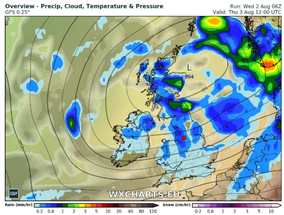
Thursday: A windy day with frequent blustery showers which could be thundery. The widespread showers should become a bit more scattered later in the day. Feeling quite warm and humid despite the rainfall. Max 19°C

Friday: Low pressure still in charge. Breezy with bright spells and showers, and some heavy. With more of a westerly airflow it will be cooler. Max 17°C

Weekend: Not too bad overall

Saturday: A cool breeze but it should not be as windy as previous days. Sunny spells and just a scattering of showers. Max 16°C

Sunday: Bright spells and any showers should fade by the afternoon as cloud increases with a risk of some light rain from the west overnight or into Monday. A little milder. Max 18°C

Outlook: Rain early next week then hopefully high pressure squeezes in from the southwest and settles things down, so becoming drier, sunnier and a little warmer. BUT, latest forecasts suggest, it will be short-lived.

July 2017 Stats

Max 24.9°C (disappointing)
Min 9.9°C
Wettest 17.4mm
Windiest 36mph
Rain 75.2mm (average)
Rainy Days 23 (ouch!)
Dry Days 8

Follow @ChadWeather on Twitter for the very latest forecast for your area.

Thanks,
Jon

Forecast Issued at 12:45pm on Wednesday the 2nd of August 2017