Becoming milder but sunshine lacking – Thursday 27th April 2023 – Bank Holiday Monday 1st May 2023

Hi all,

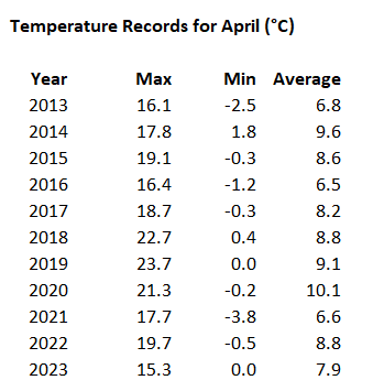
It’s not been the best April when it comes to warmth with temperatures below-average. It’s the 4th coolest April looking back through the last 11 years of my data. We haven’t risen above 15°C yet.

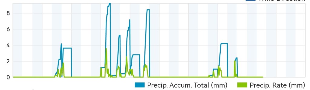
At least the last week or so hasn’t been as wet as earlier in the month. Rainfall amounts are currently coming in at 86% of average.

The second half of April hasn’t been as wet as the first.

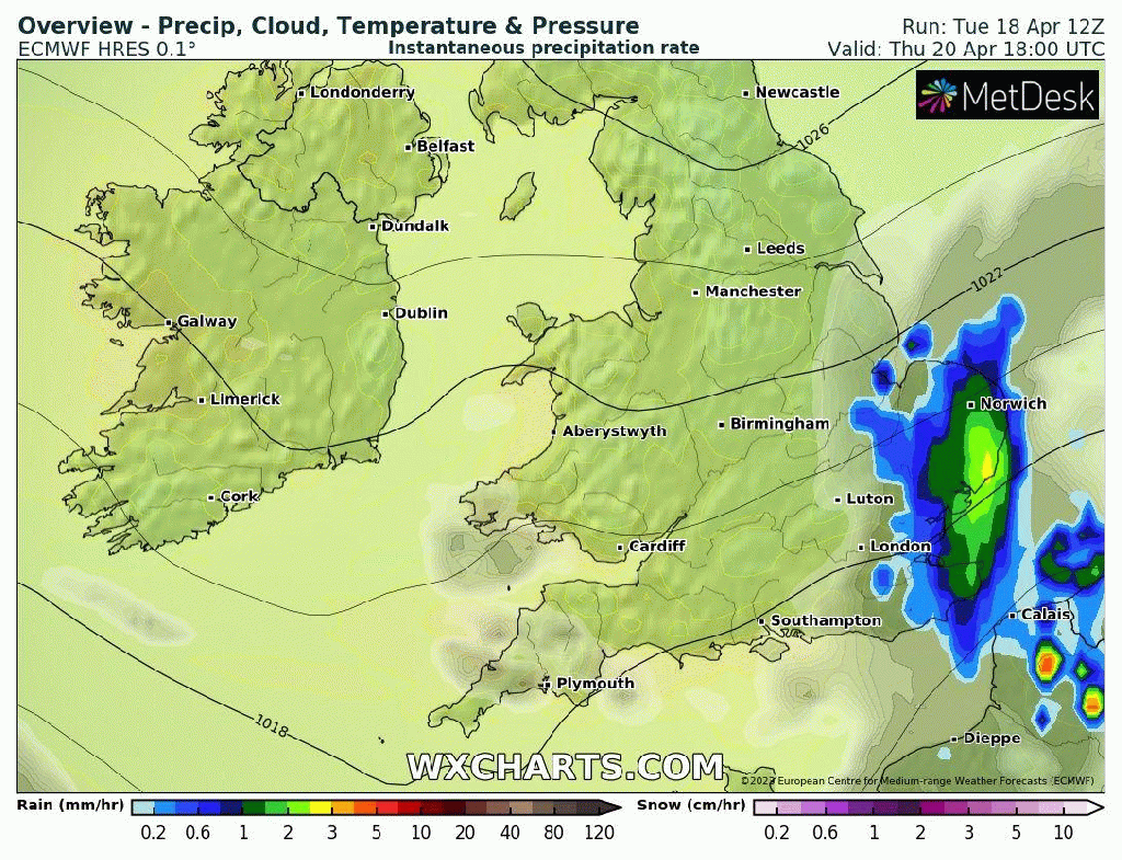
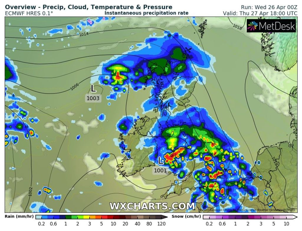
Thursday: A fresh start in places with sunny spells. Cloud thickening into the afternoon with rain eventually arriving into the evening, with some heavy bursts. Temperatures up a notch on recent days. Max 13°C

A wet Thursday evening is on the cards.

Friday: Early rain will fizzle away but it will remain cloudy. Hopefully some late-in-the-day sunshine to come. Milder. Max 15°C

Weekend: Feeling a little warmer but lacking in sunshine.

Saturday: A mostly cloudy day as we sit in a slack airflow in between weather systems. This means light winds hence the stubborn cloud. A few bright spells later will help to lift the temperatures but could spark isolated showers. Max 16°C

Sunday: Showers are expected to be more frequent in between mostly cloudy skies. Light winds mean any showers will be slow-moving. Max 15°C

Bank Holiday Monday: Occasional bright spells and showers. Bit more of a breeze. Max 14°C

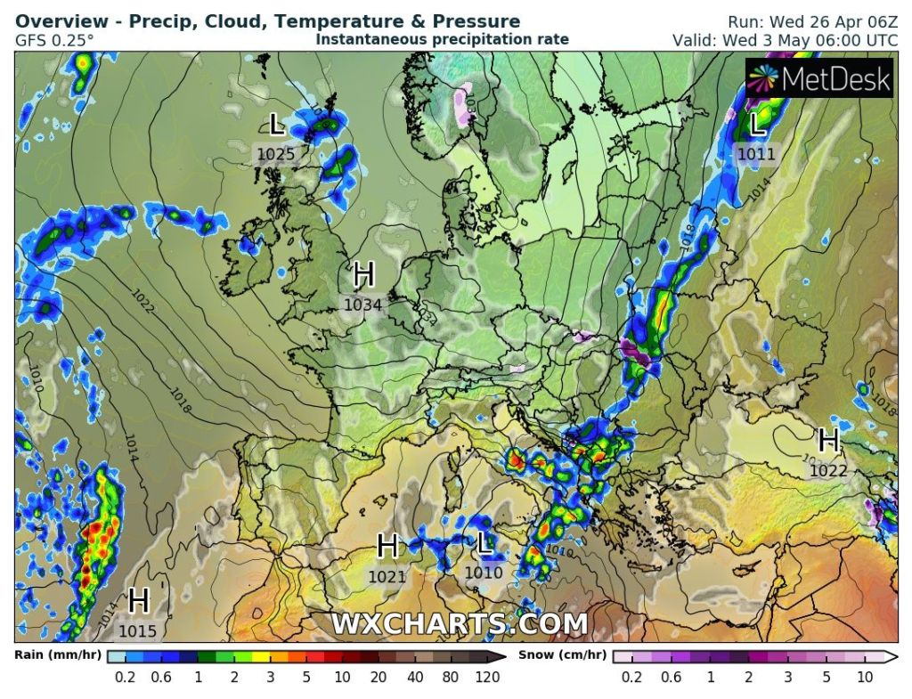
Outlook: A tricky set up. A weak area of high pressure will be close by but not strong enough to bring dry and sunny conditions every day. More like variable cloud for most of the week, so brightness at a premium and some showers brewing up. Temperatures around average.

High pressure next week but it’s weak.

Follow @ChadWeather on Twitter for the latest forecasts and warnings.

Thanks,
Jon

Forecast Issued: Wednesday the 26th of April 2023 at 5:30pm.
Images: http://www.wxcharts.com

Rain to return then temperatures falling to below average – Thursday 20th April 2023 – Sunday 23rd April 2023

Hi all,

We’re halfway through Spring but some of the media outlets have started throwing clickbait articles out there for a mini-heatwave (they can’t happen, like a mini-tornado isn’t a thing) and 40°C temperatures this summer. Nothing but Jackanory for clicks. In truth, nobody knows what summer will bring, and temperatures reaching 40°C is about a 1% chance, so yes it’s possible but predicting what is coming in 4-5 days is hard enough let alone trying to say what summer will deliver, when we’re six weeks away from starting it, is just crazy. So you know the rule. Ignore and don’t click the link.

April can be a fickle month and we’ve certainly had some ups and downs already. Easter was nice, for most of it and we’ve had some decent sunny days but rain is never too far away. This current settled spell, albeit windy, had brought more welcome sunshine but again it’s not set to last, with rain returning before the weekend, then a cold northerly airflow drops the mercury into next week.

Thursday: A chilly start with a touch of ground-frost in the most sheltered of spots. Last of the sunny days with plenty on offer and remember it is now giving UV levels of 5, so don’t forget your suncream. It will again be windy, locally 30mph. Cloud will increase later into the evening. Pleasant where sheltered. Max 14°C

Friday: Cloud and a developing area of low pressure will bring rain. There will be the odd heavier burst and it will be showery at times. Feeling cooler with a fresh wind, again gusty. Max 10°C

A wet Friday on the cards as a low pressure begins to develop

Weekend: Not much to cheer about.

Saturday: With low pressure now in place it will be unsettled. Showers with some bright spells here and there. Not as windy as recent days if you’re looking for something to note as an improvement. Max 12°C

Sunday: Overall drier but it will still be cloudy with the odd area of patchy rain. Max 11°C

Outlook: Colder air will come down from the north during Sunday night leading to a chilly Monday with mostly cloudy skies. Tuesday sees some bright spells but cold with temperatures to stay in single-figures and the risk of a frost overnight is there. Similar on Wednesday before the temperature begins to recover during the latter stages of the week but it is looking to stay unsettled. The wait will be on for the next settled spell of warm sunshine and dry days.

Follow @ChadWeather on Twitter for the latest forecasts and warnings.

Thanks,

Jon

Forecast Issued: Wednesday the 19th of April 2023 at 4:42pm.

Images: http://www.wxcharts.com

Unsettled at first then much-improved and temperatures rise for a promising week – Thursday 13th April 2023 – Sunday 16th April 2023

Hi all,

As predicted we had a settled Easter and also much more sunshine than I thought. It wasn’t that warm on the thermometer but it was perfect during the day and the sun felt so warm. The sun is now as strong as late-August and suncream is needed if you don’t want to burn and are in the sun between 11am-3pm.

Our weather has now turned poor once again and it’s been a wet and windy week as well as being cooler as the Jet Stream drives weather systems across from the Atlantic.

But, good news, we have another settled spell on the way and with any luck temperatures could get close to 20°C. Only downside might be a nagging south-easterly or even easterly wind. Before this what do the next four days hold…..

Thursday: The low pressure of recent days, Storm Noa, is still affecting our weather. Feeling chilly with a brisk westerly wind and frequent showers. Windy with 30-35mph gusts especially in downpours. Chance of hail, and thunder and lightning. Max 9°C

The set-up on Thursday favours a very showery day.

Friday: Mostly cloudy with a few showers. Not as cold and not as windy. Risk of some evening rain which will clear overnight. Max 11°C

Weekend: Getting milder and drier.

Saturday: Sunny spells to start then cloud building. It is likely to stay dry. Temperatures edging up. Max 13°C

Sunday: A mostly cloudy day with some bright spells later. A southerly wind lifting temperatures, a sign of things to come. Max 16°C

Outlook: High pressure to our north-east introducing a, gusty at times, breeze from the south-east. Sunny spells and a lot of dry weather for most of the week with temperatures lifting to 17-19°C, depending on the wind direction/position of the high pressure. If winds turn easterly then the west will be the warmest place to be. With clear spells at night it will be chilly at times.

I’m hopeful this decent weather will still be around for next weekend. First BBQ of the season?

Above average temperatures favourable next week.

Follow @ChadWeather on Twitter for the latest forecasts and warnings.

Thanks,
Jon

Forecast Issued: Wednesday 12th April 2023 at 8:20pm.
Images: http://www.wxcharts.com

A settled Easter but cloud to spoil the sunshine come the weekend and save those indoor chores for BHM – Thursday 6th April 2023 – Bank Holiday Monday 10th April 2023

Hi all,

What a lovely few days we had earlier this week. Frosty mornings then some welcome Spring sunshine. Perfect. The rain is back but not for long. The Easter Holiday is looking good enough but goes downhill into Bank Holiday Monday.

Thursday: Cloudy with patchy rain moving away early doors albeit slowly. Sunny spells then follow, with some showers in between, some heavy with a risk of thunder. Any showers should then ease leaving a drier afternoon with some bright spells before sunset. A cooler north-westerly breeze. Max 10°C

Good Friday: High pressure returns so a decent day is expected with plenty of pleasant sunshine and light winds after a misty start. Cloud increasing later in the day from the east. Max 12°C

Weekend: Cloud to spoil the sunshine.

Saturday: A misty start again with some low-cloud which is going to be stubborn to shift. This means a cloudier day with some bright or sunny spells eventually sneaking through into the afternoon. A little milder. Max 13°C

Sunday: Bright spells fading as cloud thickens. Feeling warmer where the sun pops out. It looks set to remain dry. Max 14°C

Bank Holiday Monday: Weather-fronts will slide in from the Atlantic and the high pressure will slip away. Cloudy with some rain expected followed by heavy showers. Max 12°C

Outlook: Little change into Tuesday/Wednesday but high pressure looks set to return slowly into the second half of the week but whether it’s full-on or just a ridge lasting a couple of days is yet to be decided.

March 2023 Stats

Max 14.1°C (30th)
Min -2.1°C (8th)
Av. 6.1°C
Wettest 16.6mm (13th)
Av. Humidity 83%
Av. Barometer 1007.3 hPa
Max Gust 34.5mph
Av. Wind Direction SW
Rain 120.6mm (145% of average)
Rain Registered Days 26
Dry Days 5

Follow @ChadWeather on Twitter for the latest forecasts and warnings.

Thanks

Jon

Forecast Issued: Wednesday the 5th of April 2023 at 8:46pm.