Thursday 29th November 2018 – Sunday 2nd December 2018

Hi all,

After a quiet two weeks the weather has now taken a turn for the worse and is more like the Autumn that we all love to hate. Rain and wind. November has been another dry month, so on the plus side, our reservoirs need this rain.

Thursday: A rapidly deepening area of low pressure will be swinging up from the south west. Initially this will bring some heavy rain followed by squally, possibly thundery showers. Winds will gust to around 45-50mph but the potential is there for a localised 75mph. A warning is in place (see Twitter) and this is a developing situation. Max 13°C

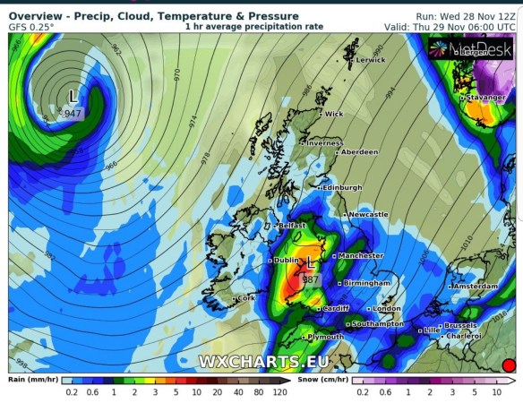
A stormy start to Thursday

Friday: Winds will continue to be gusty. Colder air will have arrived too, but much brighter with sunny spells and showers. Max 8°C

Weekend: Unsettled and feeling cool

Saturday: Heavy rain arriving from the southwest with steady winds. Not as windy as previously this week. Rain easing during the day. Max 11°C

Sunday: A little cooler. Mostly cloudy with some patchy rain. Max 10°C

Outlook: Colder and drier and generally more settled.

November’s full weather statistics to follow.

Follow @ChadWeather on Twitter for your latest forecasts.

Thanks,
Jon

Forecast Issued: Wednesday the 28th of November 2018 at 19:35
Image: wxcharts.eu

Thursday 22nd November 2018 – Sunday 25th November 2018

Hi all,

Those easterly winds have really made themselves known over the last couple of days, giving us a sub-zero wind-chill and some ‘cold-rain’. However, parts of the Pennines and the Snake Pass had a good spell of wet-snow causing some hazardous driving conditions.

Thursday: A bright start with a few sunny spells after a cold night with a touch of ground frost. Cloud will soon increase from the east on a keen breeze. This cloud will bring some light rain or drizzle, especially to the hills feeling cold once more. Max 7°C

Friday: Another cold day with quite a bit of cloud knocking around. The odd pocket of brightness but it should remain dry and slightly less breezy. Max 8°C

Weekend: Remaining cold

Saturday: We remain chilly with an east to northeasterly airflow. Mostly dry conditions across the region; just a chance of the old shower towards the hills. Max 8°C

Sunday: Little change. Cold, plenty of cloud, perhaps a bit more brightness than yesterday. Max 8°C

Outlook: Staying cold with a couple of frosts at night for the first few days. Mostly dry during the daytimes with occasional brightness. Some showers likely midweek and we continue to keep the east or southeasterly airflow, hence temperatures below normal. Milder weather will try to push in, in time for the weekend.

Follow @ChadWeather on Twitter for the latest forecasts.

Thanks,
Jon

Forecast Issued at 5:25pm on Wednesday the 21st of November 2018

Thursday 15th November 2018 – Sunday 18th November 2018

Hi,

We have a sniff of easterly winds on the way and that has meant only one thing this week… the media going to town on snow is on its way, not to mention the Beast from the East. One thing for sure, November is looking like a very dry month, but snow?

Thursday: The mildest day of the forecast with southwesterly winds putting the temperatures up into the mid-teens. A mostly cloudy start with a few mist and fog patches but where this breaks during the day we will see some sunshine. Dry throughout but a little breezy. Max 15°C

Friday: Again a misty start, but the cloud is not expected to break up as much as Thursday so less in the way of sunshine. Winds now southerly so temperatures not too bad but a little down on yesterday with more in the way of cloud. Dry. Max 14°C

Weekend: Slowly cooler but sunnier and staying dry

Saturday: We see a change in wind direction, which mean temperatures will slowly drop during the day. Still dry but good news, more in the way of sunshine, as drier air feeds in from the east. Keen breeze. Max 11°C

Sunday: Bright spells but a sharp easterly wind making it feel quite chilly. Dry once more. Max 10°C

Outlook: Easterly and northeasterly winds take charge feeding in cold air from the continent. High pressure will be anchored to the northeast of the UK, keeping this weather pattern in place for the week. As it gets colder there will be a chance of some overnight frosts where the cloud breaks and winds fall light. Temperatures struggling to maximums of 7-8°C but no snow.

Beyond: There are signs that this colder-than-average weather will continue to the end of the month but this is a long way off and subject to change. If the charts are to be believed for the last week in November, then some snow showers from the east are possible. Now where do I put my pinch of salt. 🙂

Colder Weather on the way

Colder weather on the way next week and possibly lasting for a while

Follow @ChadWeather on Twitter for your local weather forecasts.

Thanks,
Jon

Forecast Issued: Wednesday the 14th of November 2018 at 13:55
Images:
 www.netweather.tv


Thursday 8th November 2018 – Sunday 11th November 2018

Hi all,

Typical Autumn is back. Gone is the early taste of winter, replaced by showers or longer spells of rain, wind and mild temperatures. The norm. Currently there is no sign of anything particularly cold in the next 7-10 days.

Thursday:  A better day than yesterday. Sunny spells and showers. These mostly confined and frequent in the north and west. Breezy. Max 12°C

Friday: A bright morning with some sunny spells and a few showers. Cloud will thicken and wind and rain will arrive into the afternoon and last into the evening. Winds increasing with gusts of 45-50mph possible later. At this stage this is not a named-storm. Max 12°C

Wind Gusts Fri

Looking particularly windy on Friday night

Weekend: Low pressure in charge

Saturday: Sunshine and scattered showers, some of them heavy on a gusty wind. Max 12°C

Sunday: Bright start then showers arriving from the southwest. Breezy. Max 11°C

Outlook: Details a bit uncertain with a lot going on but expect us to remain mild under the southwesterly winds. Some showers at times.

Mild next week

Midweek max temps – Remaining generally mild

Follow @ChadWeather on Twitter for the latest weather forecasts.

Thanks,
Jon

Forecast Issued: Wednesday the 7th of November 2018 at 1:45pm
Image:
 https://www.theweatheroutlook.com