Thursday 26th April 2018 – Sunday 29th April 2018

Hi all,

This time last week we were entering a few days of summer-like weather and oh how good it felt, but it already feels like an age ago. Yep, we are back to our standard Spring.

Thursday: Sunshine and showers, some heavy with hail and thunder possible but fewer showers than yesterday. Max 12°C

Friday

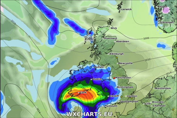
Some uncertainty about the track of this low on Friday but potential for heavy rain 

Friday: Bright spells to start but soon thicker cloud will spread up from the southwest with rain, some heavy too, especially in southern areas. Feeling cool. Max 10°C

Weekend: We remain on the northern side of the Jet Stream so cool and showery with chilly nights.

Saturday: Friday’s low will have moved away into the North Sea allowing a cool northerly or northeasterly airflow to bring showers down across the region. Chilly. Max 11°C

Sunday: Bright spells and a few well-scattered showers. Catch one and it will be heavy. A cool breeze. Max 11°C

Outlook: We enter May with unsettled and cool weather in charge. No sign of any sunny and warm conditions returning.

Follow @ChadWeather on Twitter for the latest forecasts.

Forecast issued on Wednesday the 25th of April 2018 at 16:20.
Image: http://wxcharts.eu

Thanks,
Jon

Thursday 19th April 2018 – Sunday 22nd April 2018

Hi,

As promised in last week’s blog, sunnier and warmer weather is coming, bringing us our first taste of summer. I also mentioned that it was set to break over the weekend and this is still the case. This is the time where gardens grow so fast you’ll have to give in and finally cut the lawn and perhaps you sneak in the first BBQ of the season.

Thursday: Breezy but a lovely day with sunny spells and very warm. Warmest day of the year so far. Dry. Max 22°C

Thursday will be the warmest day of the year so far

Friday: A misty start in places but another nice day with sunny spells. We lose the warm southeasterly wind direction for today and switch westerly meaning it will be a cooler. Max 17°C

Weekend: Saturday’s best.

Saturday: Little change during the day. Sunny spells, very warm and pleasant. Cloud will bubble up though and there is a chance of showers breaking out into the evening as high pressure slips away. Max 19°C

Showers possible later on Saturday becoming more widespread and perhaps thundery on Sunday

Sunday: The breakdown arrives with heavy, perhaps thundery showers spreading in from the west. Cooler. Max 16°C

Throughout the period UV levels will be between 4-5 and the sun is as strong as late-August. So don’t forget your sun-cream if you’re out in it for a long period of time.

Outlook: All change as our weather starts to come in from the Atlantic again. So, cooler, cloudier and eventually wet with rain at times. Temperatures back into the teens. So make sure you enjoy this warm spell.

Follow @ChadWeather on Twitter for the latest weather forecasts.

Thanks,
Jon

Forecast Issued on Wednesday the 18th of April 2018 at 2:10pm.
Images: https://www.netweather.tv

Thursday 12th April 2018 – Sunday 15th April 2018

Hi all,

Finally some warmer weather on the horizon. This time next week I might have dug the shorts out and be planning a BBQ. Of course this is all down to the forecast panning out as planned over the next 6-8 days. We deserve something settled, sunny and warm so fingers crossed.

Thursday: A mostly cloudy day with a cool easterly breeze still affecting the region. This might drag in some drizzle or light rain at times, especially during the morning. Cold. Max 9°C

Friday: Little change. Hopefully less in the way of drizzle and some brightness breaking through here and there as we enter the afternoon. A touch less cold. Max 12°C

Weekend: Mostly dry, slowly warmer.

Saturday: Dry but mostly cloudy,  thickest the further west you are. Just a chance of some isolated patchy drizzle for the morning. Milder. Max 14°C

Sunday: Bright spells and again most areas dry. Southerly winds helping to lift the temperature and we should see some warm sunny spells late in the day. Max 16°C

Temps Wed

Temperatures up to 20°C by Wednesday next week

Outlook: High pressure building and dragging warmer air up from the south/southeast. Cloudier and breezier in western areas otherwise sunny spells and warming up nicely. I’m not promising wall-to-wall sunshine but more so sunny intervals. UV levels in the sunshine up to 4/5, so time to work on your tan and sun-cream routine. We could well sneak a 20°C by midweek and see our warmest weather since August 2017, if we beat 20.2°C. How long will it last? This warm spell looks set to break over the weekend.

Forecast issued at 9:45am on Wednesday the 11th of April 2018.
Images: http://wxcharts.eu

Thanks,
Jon

Thursday 5th April 2018 – Sunday 8th April 2018

Hi all,

Winter has had a final few bites at us over the past few weeks, with some snowfalls and the bitter wind from the ‘Beast from the East 2’. We even managed snow on Easter Sunday, but don’t be surprised. Snow at Easter is more likely than snow at Christmas. March overall was a colder-than-average month but much drier than normal. It did actually rain on 23 days of the 31, but amounts were small. Is that the last of the snow? Yes, I think so.

UV Levels 04-04-2018

UV levels up to 3 and 4 on Thursday. Time to soak up the sun’s rays.


Thursday:
A cold and frosty start for some, but a lovely day ahead with pleasant sunny spells. Dare I say it, UV levels are now up to 3-4 which means you will catch the sun if you’re out in it for a few hours and we’ll soon we talking about sun-cream again! Max 11°C

Friday: A dry morning with sunny spells. Cloud increasing into the afternoon with rain arriving after dark. Milder as winds increase and drag up air from the southwest. Max 13°C

Saturday: Cloudy with some rain but this should ease away during the day with some bright spells developing later on. A few evening showers are possible. Max 12°C

Sunday: A mostly overcast day but some sunny spells developing later and it should be mostly dry. Any decent sunny spells will lift the temperatures quickly. Max 13°C

Outlook: A cloudy set-up and quite cool. Perhaps signs of something a little warmer past mid-month. Sooner or later a decent Spring spell will arrive.

Follow @ChadWeather on Twitter for the latest forecasts.

March 2018 Stats

Max 13.7°C (10th)
Min -5.9°C (1st)
Av. 4.4°C (colder than average)
Wettest 8.2mm
Windiest 47mph
Rain 51.8mm (57% of average)
Rainy Days 23
Dry Days 8
Air Frosts 8 (more than average)
Snow Falling Days 4
Snow Lying Days 6

Thanks,
Jon

Forecast Issued at 5pm on Wednesday the 4th of April 2018.
Image: http://weatheronline.co.uk