Finally August is delivering some settled weather. OK it’s a bit cloudy at times, as some cloud feeds in from the North Sea, but the warm sunny spells are welcome after the first two-thirds of the month were so poor.
The sun might only be as strong as mid-April but the UV is still high enough for sun-cream to be needed, mostly between 11am-3pm, on sunny days.
Thursday & Friday: Some sunny spells, especially in the west, with some troublesome cloud at times further east. Feeling warm in any sunshine. Max 18-20°C
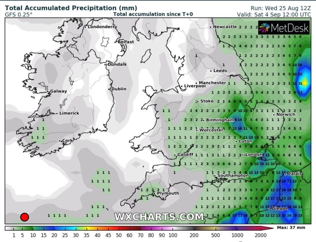
No measurable rainfall over the next 10 days.
Weekend: Hopefully more in the way of sunshine.
Saturday: Any morning cloud burning off to a warm day with plenty of sunny spells. Max 20°C
Sunday: More of the same. Warm with sunny spells and dry. Some areas of frustrating cloud at times. Max 20°C
Bank Holiday Monday: It will be dry with bright or sunny spells. Cloud amounts hard to predict but likely to be a cloudy start again. Max 19°C
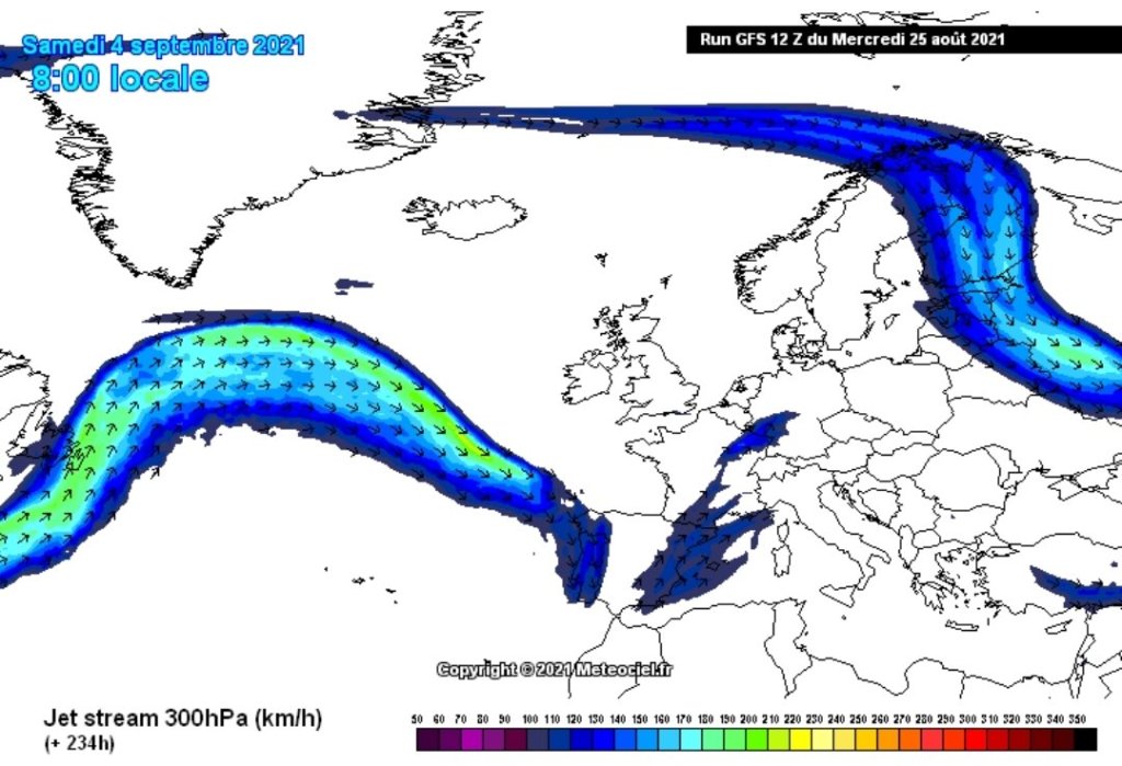
The Jet Stream, which brings unsettled conditions, is set to avoid the UK for the next 10 days at least.
Outlook: It looks like high pressure will continue to dominate the weather for a few more days, perhaps most of next week. So, more of the same, pleasant temperatures, variable cloud and sunny spells at times.
Thanks for reading. Jon
Forecast Issued: Wednesday the 25th of August 2021 at 8:50pm
What a dreadful month August is turning out to be. The average maximum temperature for August is 19.5°C. Currently we are sitting at 18.2°C, so much cooler than normal and with limited sunshine. Rainfall is above average so far too but with a drier end to the month looking likely, this figure could well level itself out. Before that, yet more rain to come.
Thursday – A cloudy start with some drizzle/rain. A spell of drier, and hopefully a little brighter for a time, weather either side of lunchtime before showery rain returns into the afternoon. Poor temperatures again. Max 18°C
Friday: A few showers possible early on then a mostly cloudy day once more, with a few bright spells. Temperatures still disappointing for August but signs of it warming up a touch. Max 21°C
Weekend: Becoming unsettled and wet.
Turning wet Saturday evening with rain; followed by thundery showers on Sunday.
Saturday: We should get away with a mostly dry morning with some warm bright spells as temperatures begin to lift under the influence of a southerly/southeasterly airflow. However, the afternoon looks set to go downhill as showers arrive, some heavy followed by more persistent rain later. Warm and humid. Max 22°C
Warm and humid for a time on Saturday with some heat dragged in from the continent for southeastern parts of the UK. It’s this that we need to tap into, for a heatwave and that isn’t on the horizon.
Sunday: An unsettled day is likely with low pressure in charge. Showers, perhaps thundery with some hail or even longer spells of rain. Slightly cooler but a muggy feel overall. Max 19°C
Outlook: Some rain at first, then, this has been trying to happen for a few days/weeks now, high pressure builds in from the northwest and settles our weather down. However, with the air coming in from the northeast/east, temperatures are expected to remain around average with quite a lot of cloud at times. We only need the high to position itself favourably and introduce a south-to-southeasterly airflow to lift temperatures. That would be the only chance of a heatwave, which for now, is just wishful thinking.
High pressure looks favourable to build giving us a drier and more settled end to August. How warm it is, or hot, all depends on its location.
Follow @ChadWeather on Twitter for the latest forecasts and warnings.
August. The final summer month and so far so… poor, with only a couple of days in the 20s and half-a-month’s worth of rain falling in just 3 days. It can only get better, right?
August so far
Thursday: Sunny spells for the morning. Cloud arriving from the southwest during the day but it is expected to remain dry but a breezy with 20-25mph gusts. Max 21°C
Friday: Windy with some bright spells. Most places dry but the odd shower can’t be ruled out. Cooler. Max 19°C
Weekend: Wet Saturday.
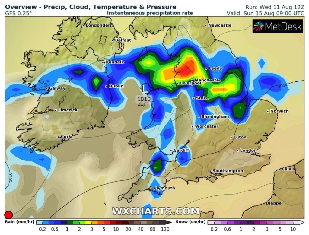
Saturday: An area of rain was set to move across Southern England but latest models suggest it comes right across NW England, so a cloudy day with rain at times. Max 18°C
Rain predicted further north that originally thought for Saturday
Sunday: Sunny spells and a fresh northwesterly breeze which will blow in some showers for the afternoon. Max 18°C
Outlook: Breezyon Monday with bright spells and the odd shower, especially in the East. As the week goes on high pressure will try and build and move in from the southwest/west but this isn’t certain. The week looks mostly bright and dry but amounts of warm sunshine will increase if the high builds.
High pressure out West next week trying to move inNo heatwave on the cards – Max temps at midday on Thursday the 19th of August
Thanks for reading and you can follow me for forecasts on Twitter, @ChadWeather.
Thanks, Jon
ForecastIssued: Wednesday the 11th of August 2021 at 8:25pm.
The final month of Summer is here and to be fair it’s been a mixed bag so far with some warm sunshine and isolated downpours or thunderstorms. If you’ve been lucky enough to miss the showers then your time has come.
Thursday: Low pressure comes in from the Atlantic. After a dry start it will become breezy and bands of showers or slightly longer spells of rain will move north-eastwards from late-morning. Some of this could be heavy and thundery. More showers follow later in the day with bright spells in between. Max 19°C
Low pressure rules the roost over the next 5 days
Friday: Very unsettled for the time of year. Frequent showers, merging at times, with perhaps hail and thunder and lightning (warning in place). Max 18°C
Weekend: Slowly improving
Saturday: I’m golfing early; so hopeful of a dry start but it isn’t expected to last as further bands of showers come in on a fresh breeze. Again, some heavy and thundery. Max 18°C
Sunday: Sunny spells and showers still around, but fewer are expected, so a bit of an improvement. Max 18°C
A lot of rain expected over the next 10 days
Outlook: Little change early on with sunny spells and showers. Midweek looks improved with a couple of better days before low pressure returns with its showers or periods of rain in time for the weekend. Meh.
July 2021 Stats
Max 30.0°C (22nd) Min 10.8°C (28th) Av. 17.2°C Av. Dew Pt 13.2°C Wettest 32.4mm (4th) Av. Humidity 79% Av. Barometer 1015.1 hPa Max Gust 20.7mph (29th) Av. Wind Direction WNW Rain 89.4mm Rain Registered Days 12 Dry Days 19
Follow @ChadWeatheron Twitter for the latest forecasts.
Thanks for reading, Jon
Forecast Issued: Wednesday the 4th of August 2021 at 9pm Images: https://wxcharts.com/