Turning unsettled – Thursday 31st October 2019 – Sunday 3rd November 2019

Hi all,

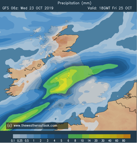
It’s been another wet month, especially so earlier in the month and after last Friday and Saturday’s deluge, which saw over 2 inches of rain fall in 24 hours. It’s turned colder recently but is there any truth of snow on the way?

Thursday: After the recent dry and cold spell, change is on the way but we squeeze out one more dry day. High pressure is starting to drift away. Bright spells, becoming cloudy later in the day with patchy rain coming in from the south-west overnight. Max 11°C

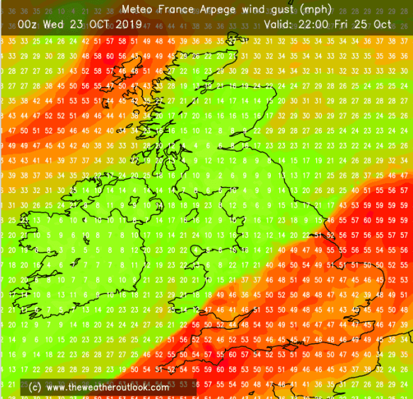
Friday: Cloudy with showery rain during the day. Some heavier bursts at times. Feeling milder but breezy. Max 13°C

Weekend: Low pressure in charge

Weekend Low Pressure

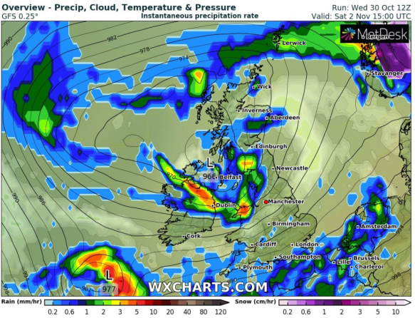
Low pressure returns and remains over the weekend

Saturday: Cloudy with rain at times. There will be some drier slots too. Still quite mild with the breeze picking up. Max 12°C

Sunday: Sunshine and showers, some heavy with hail. Windy and a little fresher. Max 11°C

Outlook: Remaining unsettled with rain or showers at times. The first couple of weeks in November look to be wetter than average. No sign of any snow but it could well turn colder around the 11th as a north or northeasterly airflow sets in; so watch this space. [Update: Small chance of a cold snap on the 5th – eyes peeled on this one]

Follow @ChadWeather on Twitter for the latest weather forecasts for your area.

Cheers
Jon

Forecast Issued: Wednesday the 30th of October at 16:20
Image:
 https://www.wxcharts.com

A blip in settled weather – Thursday 24th October 2019 – Sunday 27th October 2019

Hi all,

Finally some settled weather. In fact that’s 6 days out of the last 7 without measurable rainfall. That said, some rain is set to return and with it a weather warning.

Thursday: A band of showery rain will move through, weakening all of the time. Bright spells following on, odd shower and a cool night under clear spells. Max 12°C

Friday's Rain

If you’ve outdoor plans Friday night then expect it to be very wet


Friday:
A dry start but cloud soon increasing as an area of low pressure tracks up from the south-west. Rain, heavy at times will arrive into the afternoon and last for the rest of the day with a weather warning in place for a risk of flooding. Parts of the Pennines could see in excess of 75mm. Windy for a time too. Parts of the North Pennines could see a short spell of sleet or wet-snow on the northern edge of the rain-band. Cold. Max 9°C

Friday's wind

Friday’s low pressure brings us rain and strong winds to southern parts of the UK (perhaps a named-storm)


Weekend: Improving all the while.

Saturday: Heavy rain set to clear away during late-morning/early afternoon followed by a cold northwesterly airflow with some bright spells and perhaps a shower. Breezy. Colder. Ground-frost overnight. Max 11°C

Sunday: A frosty start possible in places then a dry day with sunny spells. A cold night follows with a touch of ground-frost. Max 11°C

Outlook: Several days of more settled weather with sunny spells and misty/foggy mornings with a touch of ground-frost. Becoming more unsettled towards the end of the week but this is still uncertain.

Follow @ChadWeather on Twitter for the latest weather forecasts.

Thanks,
Jon

Forecast Issued at 2:30pm on Wednesday the 23rd of October 2019
Images: www.theweatheroutlook.com


Showery – Thursday 17th October 2019 – Sunday 20th October 2019

Hi all,

We’ve only had 2 dry days so far in October and although more rain is on the way it is in the form of showers rather than heavy persistent areas of rain.

LOW

Low pressure is coming and will hang around for a few days

Thursday: Low pressure comes in from the west bringing some showers for late-afternoon and evening. It should be a pleasant morning with sunny spells. Max 14°C

Friday: A cool day with mostly cloudy skies and a few localised hefty showers. Max 13°C

Weekend: Showery then improving

Saturday: Light winds with bright spells and some showers. Some areas staying dry. Catch a shower and it could be thundery and prolonged. Max 13°C

Sunday: Any morning showers fading as the low slips away to the south-east. Bright spells developing and becoming drier. Max 12°C

Outlook: A brief ridge of high pressure means a few drier days with sunny spells. Any lengthy clear spells will lead to a touch of frost overnight. The high is set to slip away midweek/Thursday so it could turn unsettled again before the chance of a short cold spell.

Cooler 26th

Brief cold snap for the final weekend of October?

Follow @ChadWeather on Twitter for the latest and most up-to-date local weather forecasts.

Thanks,
Jon

Forecast Issued on Wednesday the 16th of October 2019 at 11:10am.
Image: https://www.wxcharts.com


It never rains but it pours – Thursday 10th October 2019 – Sunday 13th October 2019

Hi all,

The rain continues. We are not even 9 full days in and we are at 56.4mm of rain for October. The monthly average is 119.3mm. On average October is the 2nd wettest month of the year so it’s no surprise we are seeing rain. It’s just too much so soon after a very wet September. More to come? How will it fair for the Manchester Half-Marathon on Sunday?

Thursday: Another low pressure arrives from the Atlantic so after a bright start with a few scattered showers, a band of rain will move from west to east. Drier into the late-afternoon and evening with bright spells, just a few scattered showers. Max 14°C

Friday: A band of rain will become slow-moving. Its exact position is still uncertain. Under the band you can expect persistent rain, warning in place, and it will feeling cool. The latest suggests the area of rain might sit just to our south-east, so some of us escaping with a mostly dry and cloudy day and milder. Max 16°C

Weekend: Wet theme continues

Saturday: Cloudy start with any rain becoming patchy. Bright spells developing but few and far between. Max 14°C 

Sunday: Some uncertainty on the forecast for this day. It seems another ripple of rain will develop along a weather front pushing some heavy bursts north-east. This will be followed by showers. Max 14°C

Outlook: More low pressures = unsettled, wet at times and breezy. No sign of anything settled.

Follow @ChadWeather on Twitter for the latest weather forecasts.

Thanks,
Jon

Forecast Issued on Wednesday the 9th of October 2019 at 13:45.

Ex-Hurricane Lorenzo – Thursday 3rd October 2019 – Sunday 6th October 2019

Hi all,

September has been one of the wettest months I have ever recorded with some relentless rain at times (109mm in the last 7 days of the month; the monthly average being 93mm!). The talk now turns to ex-Hurricane Lorenzo, named Storm Lorenzo by the Irish Met Office, and how it will affect the UK. As usual a lot of media talk but this will arrive close to our shores as nothing more than a deep area of low pressure which is not unusual for autumn.

Lorenzo 2

Ex-Hurricane Lorenzo will bring strong winds to parts of Ireland and the SW of England but won’t cause us any issues

Thursday: A chilly start followed by bright spells. These will fade as cloud builds from the southwest. Some rain likely later in the evening/overnight. Turning milder. Max 13°C

Friday: More rain to come during the morning, clearing quickly. Bright spells into the afternoon, especially in the west. Some drizzle returning in the east later. Much milder as we get some humid air from the fast-decaying Lorenzo. Max 15°C

Weekend: Mild, some rain.

Saturday: A mostly cloudy day with a few bright spells. Rain will arrive from the west towards evening. Max 15°C

Sunday: Rain or showers easing as a small ridge of high pressure brings drier and brighter weather for the afternoon. Max 14°C

Outlook: Little change at first with showers then becoming a little more settled with light winds later in the week.

Follow @ChadWeather on Twitter for the latest updates.

September 2019 Stats

Max 22.8°C (21st)
Min 4.9°C (8th)
Av. 12.9°C
Av. Dew Pt 10.1°C
Wettest 35mm (29th)
Highest UV 4.7
Av. Humidity 84%
Av. Barometer 1016.8 hPa
Max Gust 37mph (4th)
Av. Wind Direction W
Rain 177mm
Rain Registered Days 20
Dry Days 10

Thanks,
Jon

Forecast Issued at 2:15pm on Wednesday the 2nd of October 2019
Image/GIF: https://www.wxcharts.com