
Hi all,
Finally some settled weather. In fact that’s 6 days out of the last 7 without measurable rainfall. That said, some rain is set to return and with it a weather warning.
Thursday: A band of showery rain will move through, weakening all of the time. Bright spells following on, odd shower and a cool night under clear spells. Max 12°C
If you’ve outdoor plans Friday night then expect it to be very wet
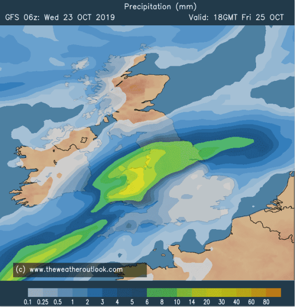
Friday: A dry start but cloud soon increasing as an area of low pressure tracks up from the south-west. Rain, heavy at times will arrive into the afternoon and last for the rest of the day with a weather warning in place for a risk of flooding. Parts of the Pennines could see in excess of 75mm. Windy for a time too. Parts of the North Pennines could see a short spell of sleet or wet-snow on the northern edge of the rain-band. Cold. Max 9°C
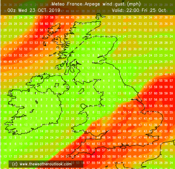
Friday’s low pressure brings us rain and strong winds to southern parts of the UK (perhaps a named-storm)
Weekend: Improving all the while.
Saturday: Heavy rain set to clear away during late-morning/early afternoon followed by a cold northwesterly airflow with some bright spells and perhaps a shower. Breezy. Colder. Ground-frost overnight. Max 11°C
Sunday: A frosty start possible in places then a dry day with sunny spells. A cold night follows with a touch of ground-frost. Max 11°C
Outlook: Several days of more settled weather with sunny spells and misty/foggy mornings with a touch of ground-frost. Becoming more unsettled towards the end of the week but this is still uncertain.
Follow @ChadWeather on Twitter for the latest weather forecasts.
Thanks,
Jon
Forecast Issued at 2:30pm on Wednesday the 23rd of October 2019
Images: www.theweatheroutlook.com
