Cooler and Wetter – Thursday 25th April 2019 – Sunday 28th April 2019

Hi all,

What a great week of weather it has been with temperatures rising into the 20s and breaking my warmest day ever recorded in April with 23.7°C (20th). It’s not unusual to have a decent, summer-like spell in late-April and our weather can soon return to the norm, as we are about to find out. After 20 days of no measurable rainfall, April Showers are back.

Thursday: A bright start fading as heavy showers, which could be thundery, will spread up from the south during the day. Much cooler. Max 14°C

Friday: Bright spells and showers developing, again some heavy with hail and thunder. Max 14°C

Weekend: Sunday seems best

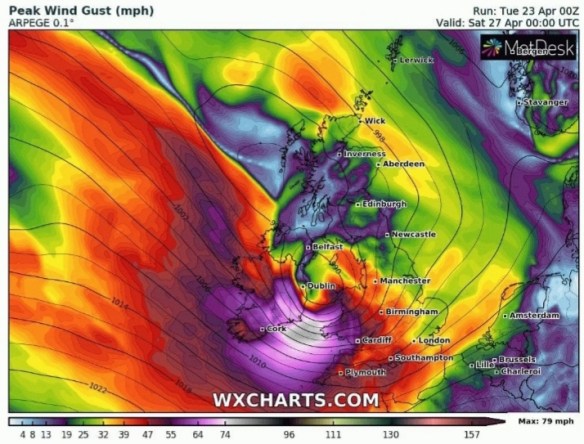
An active and lively low pressure could well develop on Saturday

Saturday: A deep area of low pressure is set to move across Southern England bringing us windy conditions and rain at times which will clear into showers towards evening. Feeling cold. Max 11°C

Sunday: A ridge of high pressure will bring more settled conditions with mostly cloudy skies. Any early showers easing during the morning. Less cold. Max 12°C

Outlook: Continuing unsettled with showers and with the Jet Stream slipping South we will remain cool.

Follow @ChadWeather on Twitter for the very latest forecasts.

Thanks,
Jon

Forecast Issued: Wednesday 24th of April 2019 at 3pm
Image: www.wxcharts.com

First taste of Summer – Thursday 18th April 2019 – Bank Holiday Monday 22nd April 2019

Hi all,

The warmer weather, that I promised a week ago, is here and its perfect timing for the Easter Holidays. Whether it lasts into the Monday is the question.

Thursday: Warm sunny spells developing after any early mist or low-cloud clears. Feeling pleasant indeed. Max 18°C

Friday: A lovely day with plenty of sunny spells and dry. Max 20°C

Weekend: Summer-like.

Saturday: A day of unbroken sunshine ahead with temperatures probably peaking for this current warm spell. Max 22°C

Sunday: Some early cloud then again dry with sunny spells developing. A little cooler. Max 20°C

Bank Holiday Monday: There were signs of the weather breaking into a pattern of showers from the west and temperatures dropping to the midteens. At this stage it looks like weather fronts won’t arrive leaving us another warm and sunny day but with the sunshine becoming hazy. Max 19°C

Outlook: Change will try and come in from the Atlantic but for now it looks to remain settled with warm temperatures and a lot of dry weather.

Follow @Chadweather on Twitter for the latest forecasts.

Thanks,

Jon

Chilly but warmer times ahead – Thursday 11th April 2019 – Sunday 14th April 2019

Hi all,

April could well turn out to be a very dry month with a lack of rain ahead. We’ve had some warm days and some chilly days recently and that pattern will continue as the weather will again be turning colder with frost.

Thursday: A cold start with a widespread frost. Plenty of sunshine on offer but it will slowly cloud over from the east towards evening. Remaining dry but chilly out of the sunshine. Max 12°C

Friday: A lot more cloud than recently and just a low chance of hill-drizzle. Feeling cold in the easterly breeze. Max 9°C

Weekend: Dry, windy and chilly

Saturday: Mostly cloudy to start but some sunny spells will break through. Feeling cold with a nagging breeze. Max 10°C

Sunday: Little change from Saturday but we can’t grumble with these dry conditions. Max 11°C

Outlook: The next 7 days look dry and becoming warmer from Tuesday. After a cloudy start sunny spells will break through and temperatures will be rising towards the late-teens.

Follow @ChadWeather on Twitter for the latest weather forecasts.

Thanks,
Jon

Forecast Issued on Wednesday the 10th of April 2019 at 4:30pm

Turning milder – Thursday 4th April 2019 – Sunday 7th April 2019

Hi all,
Into April we go and British Summer Time is officially here. After the Saturday-flooding a few weeks ago, we have enjoyed a decent dry spell but our fortunes changed earlier this week as colder air arrived from the north-west with the well-known April showers. Will it improve?
Thursday: After a chilly night with a few wintry showers (perhaps a snow-cover for the tops) the day looks set to be dry with the showers staying away to our north and south. Max 9°C
Friday: Bright or sunny spells, especially towards the east and earlier on in the day. It will also be notably milder than the last few days. Max 12°C
Weekend: Generally dry
 
Saturday: A chilly start with sunny spells for the morning. Into the afternoon an easterly wind will drag in moisture off the North Sea and push a lot of cloud across the region. Some drizzle at times on the tops can’t be ruled out late-evening. Max 12°C
 
Sunday: Mostly dry but with a lot of cloud which will break to give us some bright spells at times. Max 11°C
 
Monday-Wednesday: A lot of dry and bright weather and feeling pleasant in any sunshine. Stay cloud-covered and it will still feel cool. No sign of any particular severe or warm weather on the way. Max 11-13°C
March 2019 Stats
Max 16.3°C (20th)
Min 0.6°C (10th)
Av. 6.8°C
Av. Dew Pt 4.0°C
Wettest 52mm (16th) (record)
Av. Humidity 83%
Av. Barometer 1014.6 hPa
Max Gust 46mph (13th)
Av. Wind Direction W
Rain 168.6mm (192% of av.)
Rain Days 20
Frosts 0
Snowfall 0.5cm
Follow @ChadWeather on Twitter for the latest forecasts.
Cheers,
Jon
Forecast issued at 14:20 on Wednesday the 3rd of April 2019