From Summer Warmth to a Winter Bite – Thursday 1st April 2021 – Bank Holiday Monday 5th April 2021

Hi all,

Well well well. What a 2 days it’s been, well maybe 2.5 as Monday afternoon wasn’t too bad either. We have ended March with a record-breaking high, 20.7°C recorded at Chadderton HQ. This smashes previous March highs.

🏆 New Record

Today (Wed 31st) beats all previous maximum temperatures for March. Records began August 2012.

Highest Temperature in March

2013 13.4°C
2014 14.8°C
2015 14.7°C
2016 13.1°C
2017 16.1°C
2018 13.7°C
2019 16.3°C
2020 17.4°C
2021 20.7°C

But you know what’s coming don’t you?

Thursday: Overnight winds will have swung to the north-east and increased allowing colder air to sink down. A cloudy start is expected with sunny spells developing widely. Dry but much colder, literally up to ten degrees in places. Max 12°C

Friday: Sunny spells for the morning but cloud is expected to thicken for the afternoon. Max 11°C

Saturday: Light winds with a cloudy start. Sunny spells developing. Max 11°C

Easter Sunday: Some sunny spells before cloud increases later. Some rain will move south later in the day/overnight, followed by much colder air from the Arctic. Some of the rain could turn to snow on the back edge, mostly above 150M. Max 10°C

Arctic air on the way for Bank Holiday Monday

Bank Holiday Monday: Brrrrrr!!! A bitter wind but at least it looks dry with sunny spells after any early-morning rain/sleet/snow clears. Temperatures well below-average. Frosty overnight. Max 6°C

Outlook: Remaining cold with night-frosts and bright spells by day. Some wintry showers possible. Slowly milder towards the weekend with a risk of rain.

Follow @ChadWeather on Twitter for the latest local forecasts.

Thanks,
Jon

Forecast Issued: Wednesday the 31st of March 2021 at 7:20pm.
GIF: http://www.wxcharts.com

Unsettled weather to return – Thursday 25th March 2021 – Sunday 28th March 2021

Hi all,

We’ve had very little rain over the past 11 days and we’ve enjoyed some settled but often cloudy conditions. Our weather has been dormant but that’s all set to change.

Thursday: Sunny spells, breezy and a few scattered showers. Feeling pleasant away from the breeze. Max 11°C

Friday: Early rain, in the form of a narrow squally band with gusty winds, will move through. Temperatures will drop away after this and leave a day of bright spells and some frequent showers. Some of these will be wintry on the hills with a chance of hail. Cooler. Max 8°C

Weekend: Breezy with showers.

Saturday: A windy day with bright spells and some fleeting showers. Milder. Max 10°C

Sunday: Sunny spells fading to cloud with some light rain or drizzle arriving later in the day. Temperatures beginning to rise. Max 12°C

Outlook: Much milder for a couple of days but limited brightness. It will also be windy with some rain possible on western-facing hills. Turning colder later in the week, so a chilly Easter looks on the cards.

Follow @ChadWeather on Twitter for the latest weather forecasts.

Thanks,
Jon

Forecast Issued: Wednesday the 24th of March 2021 at 8:50pm

Very quiet and mostly dry – Thursday 18th March 2021 – Sunday 21st March 2021

Hi all,

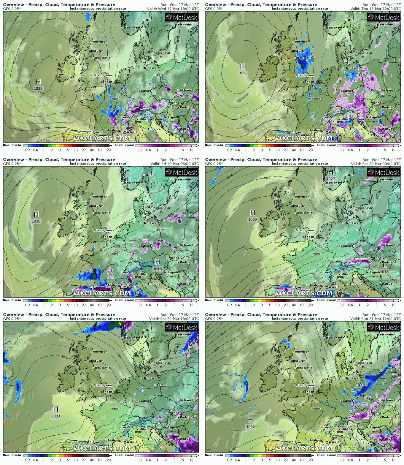
High pressure is in charge of our weather and with that comes a lot of dry and uneventful weather. Good for the gardens to have a rest after last week’s rain.

Thursday to Sunday all similar days with mostly cloudy skies. Occasionally some bright spells will sneak through, especially on Thursday, which looks the mildest at 11-13°C. There is just the chance of a shower developing locally on Sunday.

Cooler for the weekend as the bright spells become more limited. Temperatures around or just below the average for the time of the year, 8-10°C.

High pressure hangs around for the next few days

No sign of any Spring-like weather yet but a lot of dry weather over the coming days, and into most, if not all of next week. Signs of the weather changing to allow some rain to arrive next weekend.

Follow @ChadWeather on Twitter for the latest forecasts.

Thanks for reading,
Jon

Forecast Issued: Wednesday the 17th of March 2021 at 7:10pm.
GIF: http://www.wxcharts.com

Windy and Showery – Thursday 11th of March 2021 – Sunday 14th March 2021

Hi all,

What a miserable day it has been today, with nearly an inch of rain here (23mm). Winds are set to increase this evening and set to be at their strongest on Thursday morning as our weather enters an unsettled spell. Take it easy out there on your commute tomorrow morning. But will it last into next week?

These places saw over an inch of rain on Thursday (up to 5pm)

Thursday: The rain from yesterday’s deep area of low pressure will have now turned showery, some of these wintry on the hills, possible hail with thunder and lightning. Feeling cool with strong winds, gusting locally to 55mph, especially for the morning. Max 8°C

Friday: Continuing windy with bright spells and heavy, frequent showers, again wintry on the tops and don’t be surprised to see hail and encounter thunder & lightning once more. Max 8°C

Weekend: Little change.

Saturday: The theme continues, bright spells with blustery, some wintry, showers after overnight/early morning rain. Windy. Max 7°C

Sunday: Fewer showers are expected with some sunny spells. Winds easing but still breezy. Not too bad if you can dodge the showers. Rain looks set to return in the evening though. Max 8°C

Outlook: Some further showers or spells of rain to start Monday but then high pressure should build and settle things down and become the dominant feature of next week. Not wall-to-wall sunshine but variable cloud and dry and settled. Temperatures around average with currently no sign of Winter returning or a burst of Spring-warmth.

Follow @ChadWeather on Twitter for the latest forecasts.

Thanks,
Jon

Forecast Issued: Wednesday the 10th of March 2021 at 5:15pm

Rain on the horizon – Thursday 4th March 2021 – Sunday 7th March 2021

Hi,

Winter is over and done with and the weather has settled down. We’ve had some gorgeous sunny blue skies recently, which meant it felt very pleasant during the day, despite not being that warm, and with some frosty nights thrown in. Now, we’ve joined the rest of England & Wales with more in the way of cloud and misty mornings. It’s not exactly rained a lot recently; time for that to change you’d think.

Thursday: Mostly cloudy and a cooler air-mass feeding in from the north-east later in the day and with it the odd shower. A chilly breeze. Patchy frost under any clear spells overnight. Max 7°C Min 1°C

Friday: Perhaps some bright spells for the morning. Cloud increasing and becoming mostly overcast. Cool but with light winds as high pressure sits over us. Max 7°C Min 0°C

Weekend: Mostly dry and settled but change ahead.

Saturday: Cloudy and dry with a few sunny spells here and there. Max 7°C Min 1°C

Sunday: Bright spells for the morning but cloud thickening later. Some showers possible before the day is out. Breezy. Max 8°C Min 3°C

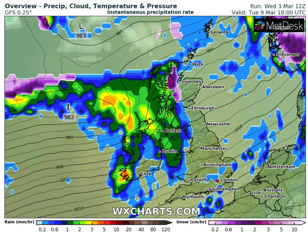
Outlook: Becoming unsettled with periods of showery rain coming in from the Atlantic. More significant rain and windier as the week progresses. So the rain returns and with temperatures around normal it will feel chilly at times.

The Atlantic influence returns next week

February 2021 Stats

Max 12.9°C (24th)
Min -4.3°C (11th)
Av. 4.7°C
Av. Dew Pt 2.0°C
Wettest 17.6mm (2nd)
Av. Humidity 83%
Av. Barometer 1014.3 hPa
Max Gust 36mph (19th)
Av. Wind Direction SSE
Rain 70mm
Rain Registered Days 14
Dry Days 15
Air Frosts 8
Snow Falling Days 3

Follow @ChadWeather on Twitter for the latest forecasts.

Thanks,
Jon

Forecast Issued: Wednesday the 3rd of March 2021 at 6:10pm
Image: http://www.wxcharts.eu