Short-lived Improvements – Thursday 1st August 2019 – Sunday 4th August 2019

Hi all,

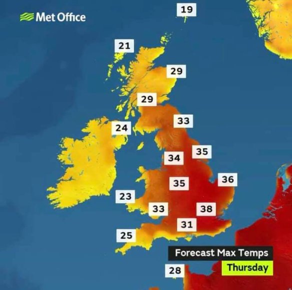
What a week of weather. A heatwave, the highest temperatures recorded for years and then unprecedented rain on Sunday. Last week saw hot air pump up from France and if 30°C wasn’t enough on the Tuesday we hit the dizzy heights of 33°C on the Thursday. Combined with the humidity, for me, it felt awful.

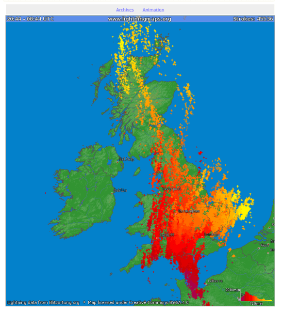
The heatwave broke down into the weekend and a weather front stalled over the region with places recording a staggering 70-100mm of rain. That’s over a month’s worth in 24 hours.


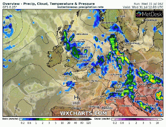
Thursday: The recent unsettled weather was down to a low pressure which is now decaying out in the North Sea. Expect sunny spells and a few thundery showers, more so over the Pennines. Warmer. Max 21°C

Friday: A similar day with sunny spells and a few showers but fewer than yesterday. Max 21°C

Weekend: Saturday’s the better day.

Saturday: A decent day by the looks of it. Sunny spells, fair-weather cloud bubbling up, warm and it should stay dry. Max 22°C

Sunday: A bright start then mostly cloudy with showers or longer spells of rain arriving in the afternoon. Breezy. Humid. Max 22°C

Outlook: After a nice Monday the rest of the week looks unsettled with showers or longer spells of rain as the Jet Stream slips South. No sign yet, of a decent August.


August

Most of the first half of August looks below average with low pressure bringing showers or longer spells of rain

July 2019 Stats

Max 33.4°C (25th)
Min 7.8°C (3rd)
Av. 16.7°C
Av. Dew Pt 12.6°C
Wettest 77.2mm (28th)
Highest UV 8.3
Av. Humidity 78%
Av. Barometer 1016.1 hPa
Max Gust 31mph (24th)
Av. Wind Direction W
Rain 155.2mm
Rain Registered Days 18
Dry Days 13

Follow @ChadWeather on Twitter for the latest weather forecasts.

Thanks,
Jon

Forecast Issued: 9pm on Wednesday the 31st of July 2019
Images: netweather.tv and wxcharts.com

Heatwave to move on – Thursday 25th July 2019 – Sunday 28th July 2019

Hi all,

I hinted at some heat last week and it certainly arrived with 28.4°C recorded on Tuesday. To follow, we had a decent thunderstorm with some much-needed torrential downpours. Record-breaking temperatures across the UK await.

45000 lightning strikes

There were over 45,000 lightning strikes across the UK on Tuesday night

Thursday: The hottest day for many years looks on the cards. I only have local records since August 2012, so my maximum temperature to beat is 30.4°C. Plenty of sunshine and high UV levels. A steady southeasterly breeze dragging in intense heat from France. Somewhere in the UK could see 38-39°C. That’s insane. Cooler further west. Risk of storms later. Max 31-33°C

HOT TEMPS

Blazing Heat: Predicted maximum temperatures on Thursday

Friday: Change arrives. A cold front will slowly push east, mostly just a band of cloud but it will introduce cooler and fresher air during the day. Some sunny spells. Temperatures some 8-10°C lower. Max 23°C

Weekend: Disappointing

Saturday: Mostly cloudy with some rain especially in eastern parts. Cooler. Max 19°C

Sunday: Again cloudy and with low pressure in the east this will mean we continue to feed some rain in at times. There is some uncertainty for the forecast at this stage so look out for updates on Twitter. Max 19°C

Outlook: Drier and brighter weather returns into next week with warm sunny spells and temperatures above normal and into the early 20s.

Follow @ChadWeather on Twitter for the very latest forecasts.

Thanks,
Jon

Forecast Issued: Wednesday the 24th of July 2019 at 1:05pm

Images: http://www.lightningmaps.org; http://www.metoffice.gov.uk

Change Ahead then Possibly Hot – Thursday 18th July 2019 – Sunday 21st July 2019

Hi all,

Maybe not us personally, but our gardens and reservoirs certainly need rain and there is some on the way. At this stage in July we would normally have had 44mm of rain. So far we sit at 4.4mm. That’s only 10% of our normal rainfall. July 2019 has also been a warm month with the average maximum sitting at 19.3°C. We’ve just had more cloudy days than sunny ones.

Thursday: Early showery rain clearing to a day of sunny spells and a few showers. Feeling fresher. Max 20°C

Friday: A dry start with bright spells. Cloud thickening from the south-west as a lively low pressure moves in. Showery rain arriving into the afternoon/evening. Max 19°C

Weekend: Warmer but unsettled.

Saturday: Rain clearing to sunshine and showers. Some of these beefy with a small chance of thunder and lightning. Turning a little muggy later on and feeling warmer. Max 21°C

Sunday: Bright spells with showers getting going as the day progresses. Some heavy and perhaps thundery. Max 22°C

Outlook: Low pressure out west and high pressure over Europe means we should stay settled with bright spells and just the odd shower. Wind direction is key. If we pick up a southerly or southeasterly then the potential is there for us to become hot with temperatures 25-28°C. If we maintain more of a southwesterly then not as hot, 21-24°C. All-in-all, a warm outlook.

Follow @ChadWeather on Twitter for the latest weather forecasts.

Thanks,
Jon

Forecast Issued at 11:20pm on Wednesday the 17th of July 2019

Settled Weekend – Thursday 11th July 2019 – Sunday 14th July 2019

Hi all,

July hasn’t turning out too badly so far. It’s quite warm and it’s not rained much. Just a bit more sunshine would be nice. The month currently has well below average rainfall (3mm so far compared to the 26mm average at Day 10) and looking ahead there is not much in the way of significant rain to come.

Thursday: A cloudy morning with periods of showery rain. This will ease into the afternoon with a few brighter skies coming through but the risk of a localised hefty downpour. Feeling warm and humid. Max 21°C

Friday: A fresher day on Friday as winds turn to a more westerly or north-westerly. This will bring a few showers during the morning but they should clear away into the afternoon as brighter skies appear across the region. Still feeling warm in any sunshine. Max 20°C

Weekend: Drier and settled.

Saturday: A dry day on the cards with plenty of sunny spells, especially so in the morning. Clouds bubbling up during the day but it is expected to remain dry and sunny spells should return towards evening. Pleasantly warm. Max 20°C

Sunday: Sunny spells with more in the way of sunshine expected than Saturday. Cloud will still bubble up during the day, and there is a low chance of a shower by late afternoon. Otherwise another dry and feeling warm day. Max 21°C

Outlook: A weak Jet Stream means next week’s weather is still uncertain. It looks like it will start dry and settled with sunshine. As the week goes on showers are expected to develop and there is an increasing chance of some warm and humid air returning from the south.

Follow @ChadWeather on Twitter for all your latest weather updates.

Thanks,
Jon

Forecast Issued at 11:55am on Wednesday the 10th of July 2019

Settled and Mostly Dry – Thursday 4th July 2019 – Sunday 7th July 2019

Hi,

No heatwave or record-breaking temperatures for us last week, but it was nice to feel some Summery weather. Not sure about you but the heat and humidity on Saturday was enough for me (high of 29.3°C) and I was glad it didn’t last. Here’s how we are looking this week.

UV levels high throughout so remember your sun-cream.

Thursday: Sunny spells. It will remain dry and very warm in the sunshine. Max 21°C

Friday: A mostly bright morning with some sunny spells but cloud will thicken from the north-west as the afternoon goes on. A weather front is moving down across the country but it will be weakening all of the while, so don’t expect much rain with some areas staying dry. Max 20°C

Weekend: Settled and slightly cooler.

Saturday: Sunny spells and fresher with a north-westerly breeze. Pleasant in the sunshine and remaining dry. Max 17°C

Sunday: A cloudy morning but a dry day with warm, bright spells developing. Just the low chance of an evening shower. Max 18°C

Outlook: A bit of uncertainty for the rest of next week. It seems that temperatures will stay close to 20°C and with some bright spells. Perhaps a little warmer by the end of the week with thundery showers developing. So again, not much in the way of rainfall.

June 2019 Stats

Max 29.3°C (29th)
Min 6.2°C (10th)
Av. 13.4°C
Av. Dew Pt 9.6°C
Wettest 11.4mm (7th)
Highest UV 8.1
Av. Humidity 79%
Av. Barometer 1014.7 hPa
Max Gust 31mph (3rd)
Av. Wind Direction WSW
Rain 73mm
Rain Registered Days 22
Dry Days 8

Follow @ChadWeather on Twitter for the latest forecasts.

Thanks,
Jon

Forecast Issued at 4:05pm on Wednesday the 3rd of July 2019