Thursday 22nd November 2018 – Sunday 25th November 2018

Hi all,

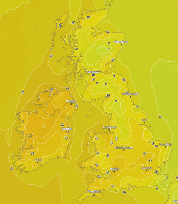
Those easterly winds have really made themselves known over the last couple of days, giving us a sub-zero wind-chill and some ‘cold-rain’. However, parts of the Pennines and the Snake Pass had a good spell of wet-snow causing some hazardous driving conditions.

Thursday: A bright start with a few sunny spells after a cold night with a touch of ground frost. Cloud will soon increase from the east on a keen breeze. This cloud will bring some light rain or drizzle, especially to the hills feeling cold once more. Max 7°C

Friday: Another cold day with quite a bit of cloud knocking around. The odd pocket of brightness but it should remain dry and slightly less breezy. Max 8°C

Weekend: Remaining cold

Saturday: We remain chilly with an east to northeasterly airflow. Mostly dry conditions across the region; just a chance of the old shower towards the hills. Max 8°C

Sunday: Little change. Cold, plenty of cloud, perhaps a bit more brightness than yesterday. Max 8°C

Outlook: Staying cold with a couple of frosts at night for the first few days. Mostly dry during the daytimes with occasional brightness. Some showers likely midweek and we continue to keep the east or southeasterly airflow, hence temperatures below normal. Milder weather will try to push in, in time for the weekend.

Follow @ChadWeather on Twitter for the latest forecasts.

Thanks,
Jon

Forecast Issued at 5:25pm on Wednesday the 21st of November 2018

Thursday 25th October 2018 – Sunday 28th October 2018

Hi all,

Much colder weather is on the way with an airflow that originates from the Arctic. A lot of talk about snow this week, but as usual, all over-hyped. That said, it will be unusually cold for the time of year and some snow will fall in Scotland and on Northern hills.

Thursday: Cloudy with a cold westerly breeze, most places dry until a bit of evening drizzle or light rain. Max 12°C

Cold Air floods South

Cold air floods South across the UK over the next few days

Friday: Some showery rain in the morning followed by brighter skies and a few sharp showers which may contain hail and thunder, and, fall as sleet or snow on the tops of the Pennines. These will ease away into the evening and move back towards the coast. Feeling much colder in that brisk northwesterly wind. Some localised frost overnight. Max 8°C

Saturday: Bright and windy with sunny spells. Some cloud bubbling up during the day especially in eastern areas, where we may see the odd shower which could be wintry over the tops. All places dry by late afternoon and evening, and a frost is expected overnight. Again feeling bitter with a northerly air flow. Max 7°C

Sunday: Most places will see plenty of sunshine after a cold start. No showers are expected, so dry but still feeling very cold for the time of year. Max 9°C

Outlook: Bright to start and still cold. Turning cloudier midweek with some light rain at times and slowly turning milder as winds turn more westerly.

Follow @ChadWeather on Twitter for the latest weather forecasts.

Have a great weekend everyone,
Jon

Issued: Wednesday the 24th of October 2018 at 7:05pm
Images: http://wxcharts.eu

Thursday 30th August 2018 – Sunday 2nd September 2018

Hi all,

August will be another month with below average rainfall (about 60% of normal). We have also lacked sunshine this month and temperatures have been pegged back for most of the time. Our average maximum temperature for August 2018, sits at 18.9°C, 0.6°C below the expected average. Will the first month of Autumn fair any better?

Thursday: Sunny spells to start then cloud bubbling up and becoming cloudy for most of the day. Dry. Max 18°C

Friday: Not much different to yesterday. Sunny spells with cloud developing. Dry again. Quite warm especially in any afternoon bright spells. Max 19°C

Weekend: Quite a lot of cloud but becoming warmer.

Saturday: Cloudy to start with some localised patchy rain. This will ease away leading to bright spells later. Warm. Max 20°C

Sunday: Mostly cloudy with some light rain or drizzle. Hopefully this will break up later leading to some very warm spells of sunshine or brightness. Max 22°C

high pressure

High pressure takes charge during the first few days of September

Outlook: High pressure will eventually build, it’s been trying to do this for a good while. So expect plenty of sunny spells and dry weather. Pleasant daytime temperatures to be had too.

Follow @ChadWeather on Twitter for the very latest forecasts.

Thanks,
Jon

Forecast Issued on Wednesday the 29th of August 2018 at 11:15am.
Image: https://www.netweather.tv/

Thursday 16th August 2018 – Sunday 19th August 2018

Hi all,

Where has summer gone? Will the heat and sunshine return anytime soon? Only 17 days until Autumn is here.

Thursday:  Any early rain will clear to much brighter skies but breezy and feeling fresher as winds swing to a west-northwesterly. It should be mostly dry with sunny spells and just the odd scattered shower, so all-in-all not a bad day at all. Max 18°C

Friday:  Mostly dry and cloudy with a brisk south-west breeze. Some showery rain late-evening and overnight. Max 18°C

Weekend: Mostly cloudy, muggy and breezy with rain on Sunday.

Saturday: Some sunny spells but again the focus is more on cloudy skies and breezy. Feeling slightly warmer and a bit muggy. Max 20°C

Sunday:  Cloudy with rain at times slowly easing later in the day. Breezy. Max 20°C

Outlook: Very little change until midweek when hopefully (didn’t happen this week), high pressure will build in from the southwest bringing more in the way of sunshine and temperatures just into the 20s but it might only last a few days. The wait for another heatwave and clear blue skies continues. The next one could well be an Indian Summer.

HIGH PRESSURE

Perhaps high pressure will be more in control towards the end of the month

Follow @ChadWeather on Twitter for the very latest forecasts.

Thanks,
Jon

Forecast Issued on Wednesday the 15th of August 2018 at 2pm.
Image: http://wxcharts.eu

Thursday 26th July 2018 – Sunday 29th July 2018

Hi all,

We’ve had some rain over the last week but we continue to be drier than average. Although there is some more rain on the way, the outlook doesn’t bring much and very warm weather will continue into August with a few hot spells at times.

Thursday: A hot day with hazy sunny spells. It will remain dry and humid. Max 29°C

Friday:  Possibly dry to start with some sunny spells. Frontal systems will arrive making the air unstable. This will set off some heavy downpours with a risk of some torrential thunderstorms, especially over the Pennines and the east of the region. Not everywhere will see one. Not as hot but still humid. Max 25°C

Weekend: Fresher for all.

Saturday: Any early showers clearing to a fresher day with plenty of sunny spells. Just the chance an afternoon shower might develop over the hills. Max 20°C

Sunday: A  bright start but cloud will increase from the southwest bringing a risk of some showers or spells of patchy rain. This is still not certain so watch out for updates. Max 21°C

Outlook: Sunny spells and a few showers early next week then perhaps becoming humid and hot again. The chart below shows the heat predicted for the 3rd of August.

HOT HOT FRI 0308

Some high temperatures again as we enter August – 36°C possible down south

Don’t forget sun-cream!

Follow @ChadWeather on Twitter for the latest forecasts.

Forecast Issued: Wednesday, July the 25th at 12:45pm.
Image: https://www.netweather.tv/

Thanks,
Jon

Thursday 7th June 2018 – Sunday 10th June 2018

Hi all,

A quick blog this week as I am on holiday.

Another week and another one of decent enough weather, for us to be enjoying the great outdoors. This is turning out to be some settled spell that has spanned the back-end of Spring and continued into Summer. It is however, time we had some rain. Shhhhhh not too loudly.

Thursday: Hazy sunny spells across the region and feeling warm and humid. Dry with light winds. Max 21°C

Friday: More in the way of cloud. Warm with bright spells at times, best in the west. Feeling muggy. Max 19°C

Weekend: Remaining warm, settled but not necessarily dry for all.

Saturday: Cloudy with some bright spells. Chance of a few showers especially in the west which could be thundery. Max 19°C

Sunday: Bright spells with a chance of an isolated shower but most places dry again. A little warmer and humid. Max 21°C

Outlook: Sunny spells but becoming cooler as winds turn northwesterly. Some rain or showers look possible later in the week and the settled weather pattern might finally be changing. Watch this space.

Follow @ChadWeather on Twitter for up-to-date forecasts.

Remember at this time of year the sun is very strong, UV levels are HIGH at 7, so apply sun-cream if you’re planning to be out in it for a while, otherwise you will burn regardless of what the temperature is.

Thanks,

Jon

Forecast issued on Wednesday the 6th of June at 5pm.

Thursday 21st January 2016 – Sunday 24th January 2016

Hi all,

Last week’s blog stated that last weekend would be dry and sunny with severe frosts as high pressure took hold. High pressure did arrive but only briefly and the forecast was shaken up, because from Friday, a system developed to our north-west. This came south-eastwards on Saturday and brought a spell of snow for most with 4-6cms of lying snow reported. Now don’t get me wrong, I like to get a forecast bob-on but it’s very welcome to spoil my plans if it delivers some snow.

A cold and frosty start to Thursday, with some isolated freezing fog patches. Cloud soon spreads in from the west with a freshening breeze later in the day. Some rain will develop into the afternoon or evening. Slowly milder. Max 5°C.

Milder air pushing out the colder air

Milder air pushing out the cold air that we have been experiencing recently

Overnight on Thursday the winds increase with heavy rain spreading from the west. So I’m expecting Friday to be a wet and breezy during the morning with the afternoon turning a little drier with the odd shower. The big change will be the temperature. With the rain comes milder south-westerly winds and by the end of the day some areas will be close to double-figures. Max 10°C.

friday rain

Heavy rain expected during Friday morning

Saturday looks the better day of the weekend with a dry day expected with some pleasant sunny spells. Mild. Max 10°C.

More cloud is likely into Sunday with bright spells limited. Some rain possible and temperatures remain on the mild to very mild side just like we were in December. Not winter-like at all. Max 12°C.

Sunday's temps

The UK under the influence of a very mild airmass by Sunday

Looking ahead and it remains mild with temperatures above average with no sign of snow returning.

Follow @ChadWeather on Twitter to catch all the latest weather updates for Manchester and its surrounding boroughs.

Photos/Data: http://www.ukweatherforecast.co.uk

Thanks for reading,

Jon

Forecast issued at 14:00 on Wednesday 20th January 2016