Showery, mild & windy – Thursday 27th October 2022 – Sunday 30th October 2022

Hi all,

A very mild but mobile outlook as bands of rain push north-east over the next few days, with brighter skies following on behind. Timings of these areas of rain will change over the coming days so look out for updates on Twitter.

Not only will the daytime maximum temperatures be above-average, we will have mild nights. Once we enter November, temperatures start to return to more nearer to normal, as winds swing westerly, perhaps north-westerly at times.

Thursday: Showery rain will move through during the morning. The afternoon will consist of bright spells and a few showers. Windy but not as gusty as Wednesday. Very mild. Max 17°C

Friday: Another windy day and with temperatures into the mid-teens. Sunny spells and showers are likely again, some heavy and more frequent during the morning. Max 16°C

Weekend: Little change.

Saturday: Cloudy with a spell of rain easing into the afternoon but staying particular overcast. Very mild and breezy. Max 17°C

Sunday: At this stage Sunday looks drier as we are sandwiched between rain out west and to our east. A strong southerly wind but a little cooler, signs of things to come. Bright spells at times. Max 15°C

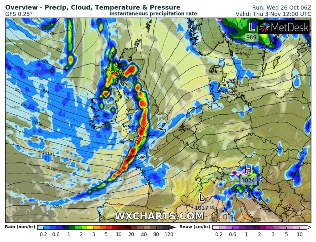
Outlook: It looks like it will turn even more unsettled with several areas of low pressures which could be quite deep bringing the risk of gales and perhaps a named-storm. Generally it will become cooler with temperatures back into the 11-13°C range.

Areas of low pressure look set to dominate next week. How deep these lows are, is yet to be determined.

Follow @ChadWeather on Twitter for the latest forecasts and warnings.

Thanks,
Jon

Forecast Issued: Wednesday the 26th of October 2022 at 7:15pm.
Images: http://www.wxcharts.com

A showery and breezy outlook – Thursday 20th October 2022 – Sunday 23rd October 2022

Hi all,

It’s likely to stay on the mild side as we go through the latter stages of the second month of autumn as winds generally come from a moist source. Tuesday was a beautiful day, cold and fresh to start, locally 3°C and lovely and warm {in the sunshine} during the day. Sitting out for my lunch felt so warm. None of that luxury over the coming weeks as showers seem to dominate.

Thursday: Less windy but generally cloudy with some patchy rain out west and localised downpours to the east, chance of thunder and lightning. Risk of some heavier rain for a time before it turns showery and then drier and brighter later in the day. Mild. Max 15°C

Risk of heavy rain: An area of heavy rain will develop over south-east England on Thursday but some models track it more towards our region.

Friday: Low pressure in charge, anchored to the south-west of the UK. A fresh breeze again with bright spells and after a dry start showers will push north-east, some heavy with thunder. Mild for the time of year. Max 16°C

Weekend: Fewer showers?

Saturday: After a cloudy start any showers should begin to fade and it turns drier with bright or sunny spells. Still breezy and mild. Max 16°C

Sunday: A nagging easterly wind and bright spells for the morning. Uncertainty for the afternoon with the chance of some rain developing to our south-west and moving in later. A bit cooler. Max 14°C

Outlook: The working week looks set to be quite mobile with low pressure parked out in the Atlantic, driving spells of showery rain across the country for most, if not all of the week. Again, some downpours will contain hail and thunder. With a south-westerly airflow temperatures are set to be above average with overnight frosts unlikely.

The final third of October looks wet to very wet across most of the UK, especially out west.

Follow @ChadWeather on Twitter for the latest forecasts and warnings.

Thanks,
Jon

Forecast Issued: Wednesday the 19th of October 2022 at 7pm.
Image: http://www.wxcharts.com

A decent Thursday but rain will return – Thursday 13th October 2022 – Sunday 16th October 2022

Hi all,

Autumnal conditions continue with more rain today, albeit patchy. It’s certainly been a wet start to October, with the monthly total already up to 35mm. There’s little in the way of anything settled and sunny for a prolonged period on the horizon, so you’ll have to make the most of some sunshine on Thursday.

Thursday: A decent day as we avoid weather systems. Sunny spells, light winds and feeling pleasant. Max 15°C

Friday: Strong and blustery westerly winds bringing a few showers/showery rain at times. Hopefully some sunny spells and drier conditions to end the day. Max 13°C

Weekend: Jet Stream back in charge. Unsettled and feeling cool at times.

Saturday: Windy with showers continuing as clouds bubble up during the day. Again, some of these showers could be heavy and thundery and winds will be gusty when they arrive. Max 13°C

Low pressure in charge brings showers aplenty on Saturday

Sunday: Little change. If anything a little less windy and showers perhaps more scattered, especially later. Cool. More general rain overnight and into Monday morning.  Max 12°C

Outlook: Hard to see anything but limited bright spells and showers as low pressure stays out to our west/south-west and in control of our weather. Nights are now looking mild as we keep a south-westerly airflow. Temperatures back up into the mid-teens early on but overall we will tend to see around average maximum temperatures for the time of year.

Follow @ChadWeather on Twitter for the latest forecasts and warnings.

Thanks for reading as always.
Jon

Forecast Issued: Wednesday the 12th of October 2022 at 4:10pm
Image: http://www.wxcharts.com

Better for the Weekend – Thursday 6th October 2022 – Sunday 9th October 2022

Hi all,

September’s stats are in and finally a month where the total rainfall was not below-average. September is definitely a month of change and it’s feeling a lot more autumnal now and we have more rain to come after a wet start to October.

Thursday: Sunny spells for the morning but cloudier for the afternoon as an area of showers moves in. Drier into the evening. Windy. Max 15°C

Friday: A band of rain will move south-east followed by bright spells and showers. Breezy. Max 14°C

Weekend: Drier with a ridge of high pressure.

Saturday: Overall not a bad day. Dry with bright or sunny spells. Not as windy as recently. Max 15°C

Sunday: Bright start with cloud increasing. Patchy rain arriving during the evening. Max 14°C

Outlook: Drier start to the working week with another ridge of high pressure but limited amounts of sunshine. More unsettled during the week as bands of showery rain return. Temperatures above-average and windy at times.

September 2022 Stats

Max 22.5°C (5th)
Min 2.9°C (28th)
Av. 13.5°C
Wettest 25mm (30th)
Av. Humidity 82%
Av. Barometer 1014.0 hPa
Max Gust 27.6mph
Av. Wind Direction W
Rain 94.2mm (average)
Rain Registered Days 17
Dry Days 13

Follow @ChadWeather on Twitter for the latest forecasts and warnings.

Thanks for reading as always.

Jon

Forecast Issued: Wednesday the 6th of October at 5:30pm.