No detailed weekly blog this week, just a quick summary, as I’m away relaxing on my holiday in sunny Corfu.
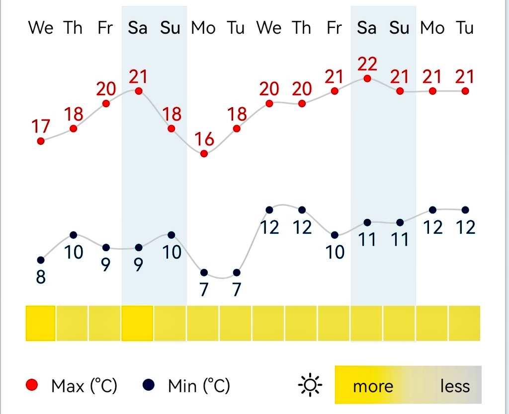
The overall picture for the next 7 days or so, is high pressure in charge but it looks likely that the position of the high will not favour a heatwave due to the airflow around it (i.e. we don’t drag up any heat from the South). That said, it will still be settled and warm at times with sunny spells on offer. Clear skies at night will allow for a few fresh mornings. Little to no rain expected. HIGH UV levels throughout.
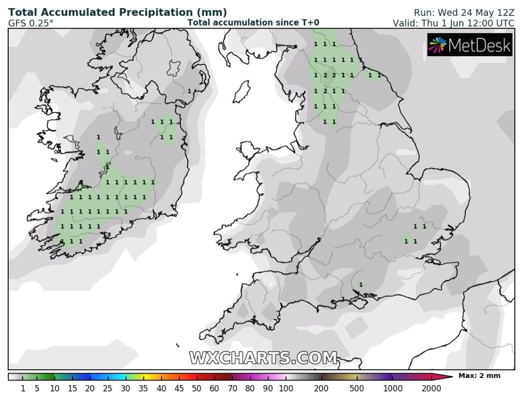
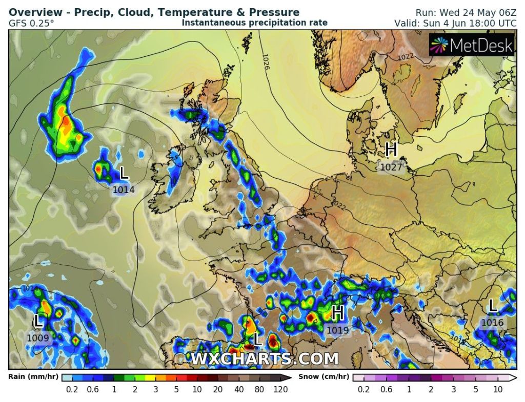
A decent outlook.Apart from the odd hill-shower it’s a very dry end to May & into early-June.It looks like the lengthy settled and warm spell might break around the 4th/5th June.
Updates will continue as always on Twitter, @ChadWeather, so head over to there for your local daily forecasts.
Thanks,
Jon
Blog Issued: Wednesday the 24th of May 2023 at 7:56pm.
I’ve played golf this week and it’s safe to say it’s drying up and quickly. May hasn’t been too bad so far and rainfall amounts are on 22.2mm (65% of the mid-month average) and with not much rain ahead, it’s going to be a dry month.
High pressure is set to mostly dominate our weather over the coming week. There will be a few weather-fronts moving south-east across the region but they will weaken as they come through the high and most of the rain-bearing clouds will stay to the north-west of the UK. This means we have a settled period of weather ahead and with the sun strong (UV 6) and very warm at this time of year; it’s going to make for some pleasant days indeed. But, no sign of a heatwave, despite what some of the media suggest. Not yet, anyway.
Thursday: Sunny spells for the morning but generally it will tend to cloud over for the afternoon. Most staying dry but the chance of a shower towards the Peak District. Max 16°C
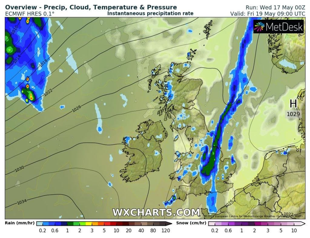
Friday: Cloudy with some patchy rain moving south-east for the morning. Bright or sunny spells for the afternoon as the cold-front clears away with the odd shower. Max 16°C
Showery rain moves south-east on Friday morning.
Weekend: Warmer with some decent sunny spells. High UV levels.
Saturday: Dry with sunny spells developing. Some fair-weather cloud bubbling up during the day. Warmer. Max 19°C
Another 20°C on the cards this weekend?
Sunday: Hopefully more in the way of sunshine albeit perhaps hazy at times. Variable and light winds. Feeling very warm in the sunshine. Max 20°C
Outlook: Not much rain expected as high pressure stays close by. So apart from the odd shower we can expect plenty of warm sunny spells and some cool nights. Just the chance of it becoming even warmer towards next weekend. Not heatwave material just yet but keep your eye on the tweets.
Very little rain over the next 7 days.
Follow @ChadWeather on Twitter for the latest forecasts and warnings.
Thanks,
Jon
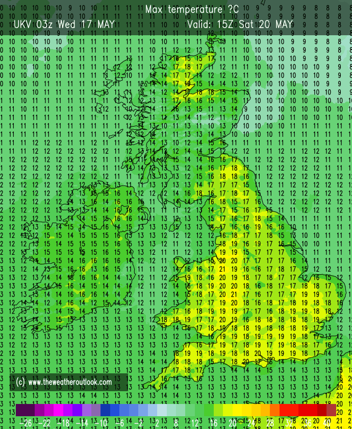
Forecast Issued: Wednesday the 17th of May at 6:30pm.
What no Bank Holiday Monday. I was getting used to that! Also, no 20°C recorded yet this Spring. We got close on Sunday, with a high of 19.6°C at Chadderton HQ. Although Saturday has a squeak, the outlook suggests the wait goes on, but in previous years we’ve waited longer.
Date of first 20°C in the year…
2013: 6th May 2014: 17th May 2015: 4th June 2016: 8th May 2017: 22nd May 2018: 18th April 2019: 19th April 2020: 10th April 2021: 31st March 2022: 14th May 2023: ………
Don’t forget that the sun is now as strong as it is in late-July with UV levels approaching high. Don’t forget your sun-cream on not just sunny days but also bright days. You can always see the burntime on my hourly stats on Twitter @OldhamWxStats.
Thursday: A day of some bright spells and showers breaking out, some heavy and possibly thundery with hail. Max 16°C
Friday: High pressure starts to build. So it should be a mostly dry day with bright and sunny spells developing, after a cloudy start. Just the chance of the odd shower on the hills. A fresh north-easterly breeze picking up, becoming quite gusty, taking the edge off the temperature. Max 16°C
Weekend: Saturday looks best.
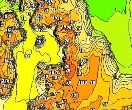
Saturday: Sunny spells developing and it should all-in-all be a nice day, especially the afternoon with lighter winds. Feeling warm and 20°C seems unlikely, but at this stage not out of the question. Max 18°C
Parts sheltered to the SW of Manchester have a chance of reaching 20°C on Saturday.
Sunday: High pressure will decline so we’re looking at a cloudier day in prospect, with winds now southerly, it will still feel reasonably warm. Rain likely overnight. Max 17°C
Outlook: Apart from a nice day on Tuesday, the week will be generally unsettled with showers, and temperatures below average, 13-16°C. A very warm summer-like spell is not likely for the foreseeable.
Follow @ChadWeather on Twitter for the latest forecasts and warnings.
Thanks, Jon
Forecast Issued: Wednesday the 10th of May 2023 at 6:35pm.
That’s two months of Spring done and it’s not exactly been a warm one. Disappointing to be fair and you would think by now we would have had, or due imminently, a spell of maximum temperatures into the 20s, but nope, nothing on the horizon. April did come out with below-average rainfall though.
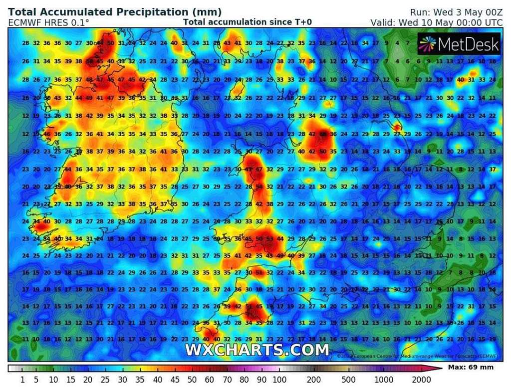
The next 10 days look set to be dominated by mostly west or south-westerly winds, so moist air, a bit humid at times and spells of rain or showers. With the sun having some strength at this time of the year, unstable air means convection and showers brew which could be thundery with hail.
Thursday: Windy, gusting 30mph, with some pleasant sunny spells at times. UV levels medium. Cloud increasing into the evening with showery rain arriving from the south-west signalling a change to more unsettled weather. Max 16°C
Looking at quite a bit of rain, over the next 7 days. Total amounts will vary due to localised downpours.
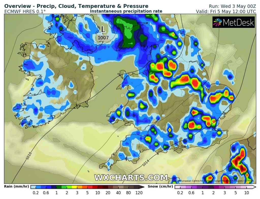
Friday: An unsettled day with hefty showers breaking out just about anywhere. These will be thundery with a risk of hail and also slow-moving with less of a breeze. Low risk of localised flooding in any downpours. Max 15°C
Downpours on Friday. Chance of thunder & lightning with hail.
Weekend: Sunday likely to be the driest or should I say leastwet.
Saturday: A dry start but mostly cloudy. Showers arriving late-morning, if not then into the afternoon, again possibly thundery and hanging around for most of the day. A little humid. Max 16°C
Sunday: Showers are expected for the morning but hopefully it will tend to become drier into the afternoon but stay mostly cloudy. Pleasant in any bright spells. Max 16°C
Bank Holiday Monday: A generally cloudy and dry morning with some brightness. Showery rain expected again as the day progresses. Max 17°C
Outlook: Little change. If anything it might stay on the cool side with temperatures struggling to the mid-teens. Still no sign of our first 20°C. It really has been a poor Spring on the thermometer.
Wet days ahead and disappointing temperatures.
April 2023 Stats
Max 17.3°C (29th) Min 0.0°C (25th) Av. 8.2°C Wettest 9.2mm (10th) Av. Humidity 77% Av. Barometer 1017.1 hPa Max Gust 38mph Av. Wind Direction SE Rain 56mm (89% of average) Rain Registered Days 14 Dry Days 16
Follow @ChadWeather on Twitter for the latest forecasts and warnings.