Record-breaking temperatures during historic heatwave – Thursday 21st July 2022 – Sunday 24th July 2022

Hi all,

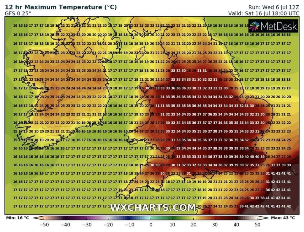
As a weather enthusiast, that was an exciting few days to witness the hot plume of air bring us the promised boiling but short-lived (thankfully!) heatwave. Records looked set to be smashed and they were, nationally and locally as the UK hit 40°C for the first time ever. When we will see those kind of temperatures again I wonder? The heatwave had all the perfect ingredients to fuel astonishing temperatures. It’ll happen again, and maybe sooner than you think, but for now, that was the Perfect Sauna and personally it wasn’t pleasant.

New National Records

Unbelievable values

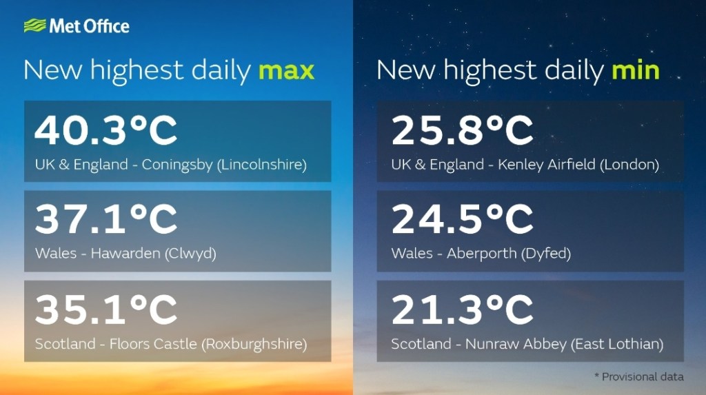
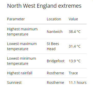
NW England Extremes (official) on Tuesday 19th July 2022

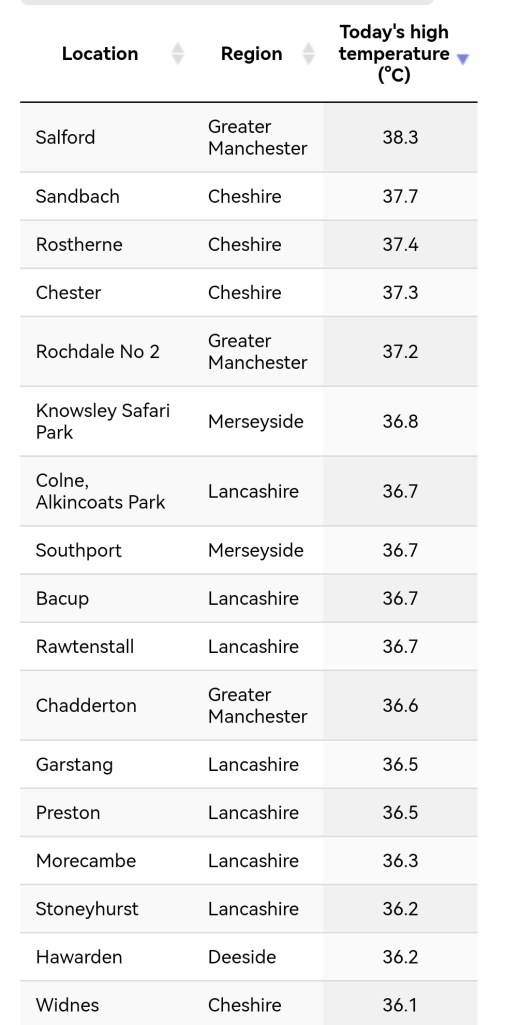
NW England Maximum Temperatures (unofficial sites) on Tuesday 19th July 2022

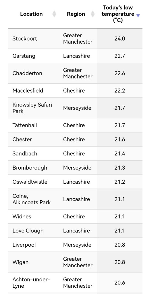
NW England Highest Minimum Temperatures (unofficial sites) on Tuesday 19th July 2022

New Records at Chadderton HQ

Highest Daytime Maximum: 36.6°C (19/07/2022)
Highest Night-time Minimum: 22.6°C (night of 18/07/2022)
Highest Temperature Recorded between 6pm & 6am: 28.5°C (19/07/2022)

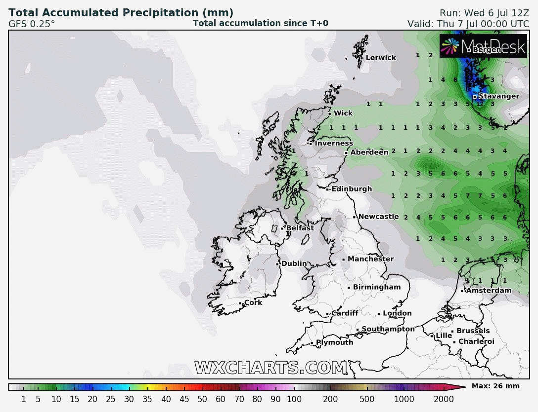
For now we’re back to normal values, but we are still experiencing very low rainfall totals (only 5.6mm for July). So far we have had 6 out of the 7 months of 2022 with lower-than-average rainfall. The environment needs rain, clearly highlighted with the amount of wildfires seen this week.

Thursday: Generally cloudy with a chance of some light patchy rain or drizzle. A lucky few will see bright spells into the afternoon but still we can’t rule out a shower. A warm night. Max 20°C

Friday: Cloudy with a weak weather-front across the region. Today was looking promising a few days ago but not now with showers likely, perhaps thundery, so the odd heavy shower but not the widespread rain we need. Max 18°C

Weekend: Low pressure approaching but temperatures rising.

Saturday: A brief ridge of high pressure leading to a dry morning with plenty of sunny spells. Cloud bubbling up into the afternoon and showers will feed in on a warm south-westerly wind, gusty at times. Humid. Max 22°C

Sunday: Bright spells and showers, risk of a thundery one as low pressure takes control. Warm or very warm in any sunshine and muggy but fresher later/overnight as a cold-front moves through. Max 23°C

Outlook: Fresher and still showery on Monday and breezy. High pressure to build, Tuesday to Thursday, so plenty of dry and quite warm weather with sunny spells. Looks like this will slip away for the weekend allowing showery conditions to return. Temperatures just below average or around average.

Follow @ChadWeather on Twitter for the latest forecasts and warnings.

Thanks,
Jon

Forecast Issued: Wednesday the 20th of July 2022 at 8:47pm
National Records & NW England Extremes: http://www.metoffice.gov.uk

Heatwave incoming with possible record-breaking temperatures – Thursday 14th July 2022 – Sunday 17th July 2022

Hi all,

It’s going to get hot again, but this time hotter and the lack of notable rain continues. The hottest day I’ve ever recorded is 33.4°C on the 25th of July 2019. This record is under threat; as is the UK’s highest ever recorded temperature, which sits at 38.7°C (July 2019). Not only will daytime records be on the line, but the night-time highest minimum temperatures will be too. Let’s face it. Some of us have to work and we don’t all have a swimming pool in our back garden to cool off in. Three days of grim conditions await.

Weather warning for extreme heat issued by the Met Office.
Details of extreme heat warning.

The heat looks set to break overnight Tuesday into Wednesday with a risk of some localised thunderstorms. The detail on this is still uncertain at this stage.

UV levels are high at this time of the year so it is easy to burn in the sunshine, especially 11am-3pm, regardless of the maximum temperature.

Thursday: We remain in average temperatures for the time of year with some sunny spells and just the chance of a shower, especially in northern parts. Breezy. Max 19°C

Friday: More in the way of cloud as a weakening weather-front brings some scattered showers. Windy at times. Max 18°C

Weekend: Becoming increasingly hot and humid.

Saturday: Sunny spells with cloud bubbling up during the day. Likely to stay dry. Lighter winds and a warm night to follow. Max 24°C Min 15°C

Sunday: Hot and humid with some bright spells of sunshine. An afternoon breeze. A sticky night and starting to become uncomfortable for sleeping. Max 27°C Min 18°C

Normally my daily forecast ends here but I’ll throw a couple more days into the mix.

Monday: The impressive waft of hot air from southern origin continues to spread across the region. More in the way of sunshine is expected and with light winds it will be hard to find some relief to escape the heat. Max 31°C Min 19°C

Tuesday: Hot with sunny periods and temperatures getting close to the local record. Can’t rule out 35°C in a few spots in the east. Of course we are still 6 days away from this date and the heat can easily be downgraded or upgraded (more likely the former) so stayed tuned on social media for updates. Max 33°C Min 19°C

Possible maximum temperatures on Tuesday. Widespread uncomfortable heat.

The hot conditions look set to breakdown overnight Tuesday into Wednesday with thunderstorms looking possible, leaving Wednesday a showery day as cooler air arrives, dropping the temperature back down to a maximum of 23°C

Thundery breakdown into Wednesday looking more likely.

Follow @ChadWeather on Twitter for the latest forecasts and warnings.

Thanks,
Jon

Forecast Issued: Wednesday the 13th of July 2022 at 6:25pm
Images: http://www.wxcharts.com & The Met Office

Very little rain and possible heatwave – Thursday 7th July 2022 – Sunday 10th July 2022

Hi all,

The first week of July has been disappointing with spells of showers and temperatures below-average but not a lot of rain has fallen (5.6mm). Our environment certainly needs rain, after the first 6 months of the year had 5 months with below-average rainfall. February being the exception.

Things are about to heat up, albeit slowly, as high pressure creeps in from the Azores. The high, this week so far, has given us cool and often cloudy conditions on a north-westerly airflow. During the weekend and into the following week it looks likely that the position of the high will be more favourable, allowing warmer air to be dragged in. How hot we get is still not certain. It depends on the high’s location and also how long it hangs around for. With very little rain on the way and drying ground, and increasing sunshine, temperatures will rise day-by-day.

The Met Office’s definition of a heatwave.

The past few days has been an eye-opener when it comes to scanning the temperature forecast, with some crazy temperatures being “predicted” for mid-July. Earlier this week, for southern parts of the UK, 41°C was being output. This is very unlikely to occur but the computer models are still outputting extreme heat for mid-July, with it likely to get into the 30s across the southern half (mostly SE) of the UK and occurring over several days. One thing to certainly note, is the lack of rainfall.

Latest (of one of the computer model’s outputs, but the most unlikely scenario) showing some record-breaking temperatures mid-month.

Remember UV is still high at this time of the year, regardless of the temperature.

Thursday: After a mild night, it will be a mostly cloudy but slightly warmer day, as we start an upward trend on the thermometer. Still that north-westerly airflow though. Brighter skies expected as the afternoon progresses. Max 19°C

Friday: Cloud drifting in from the north-west at times, some brightness here and there. Warm in any sunshine. Max 19°C

Weekend: More in the way of sunny spells after cloudy starts. Warmer.

Saturday: Cloudy with sunny spells developing. Pleasantly warm with a mostly gentle breeze. Max 20°C

Sunday: Sunny spells and dry. A little warmer once more. Max 22°C

Outlook: High pressure to dominate. Lots of dry weather and sunny spells. If temperatures do become hot, then we could have a few home-grown thunderstorms to look out for. I would expect to see 24-27°C across the region during the first half of the week with temperatures into the 30s down south. As I mentioned, how high the mercury rises and how long the heatwave lasts is still uncertain and it all depends on the location of the high and its airflow. Some humid and muggy nights to come and evenings watering the garden.

NW England: Very little or no rain expected over the next 10 days.


Follow @ChadWeather on Twitter for the latest forecasts and warnings.

Thanks,
Jon

Forecast Issued: Wednesday the 6th of July 2022 at 6:45pm
Images: http://www.wxcharts.com & http://www.metoffice.gov.uk