Temperatures recovering after winter bites back – Thursday 31st March 2022 – Sunday 3rd April 2022

Hi all,

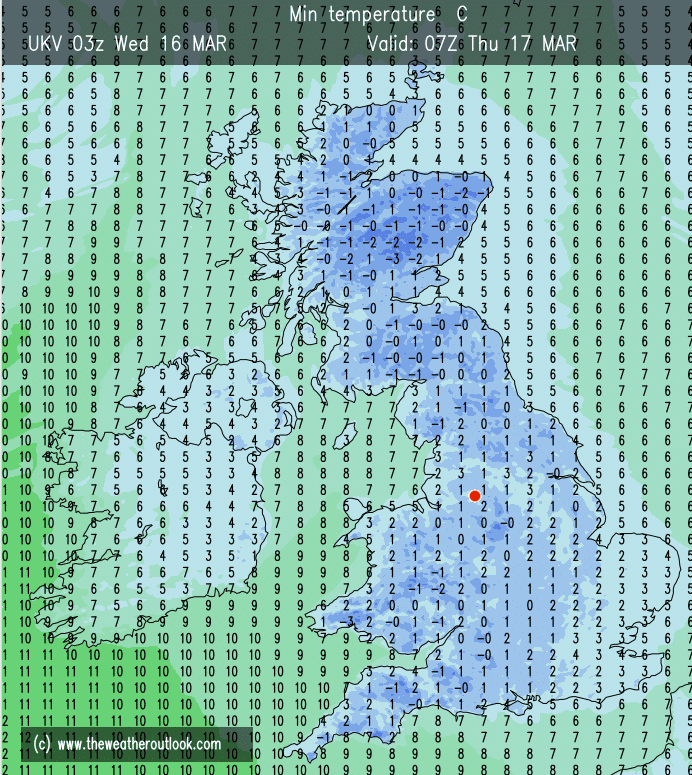
It certainly feels like winter has returned out there today, as Arctic air plunges down across the region bringing cold-rain, sleet and some hill-snow. From 18°C a week ago to just 3.6°C at lunchtime today. Ouch.

3pm temperatures each day since last Wednesday – big change today

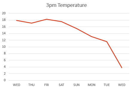
It’s not unusual to get a cold-snap at this time of the year, as late-March can be a fickle period of weather. The warmth and blue skies, albeit it hazy with pollution, were amazing but all good things have to end eventually, you just have to make the most of these pleasant spells, especially in the UK.

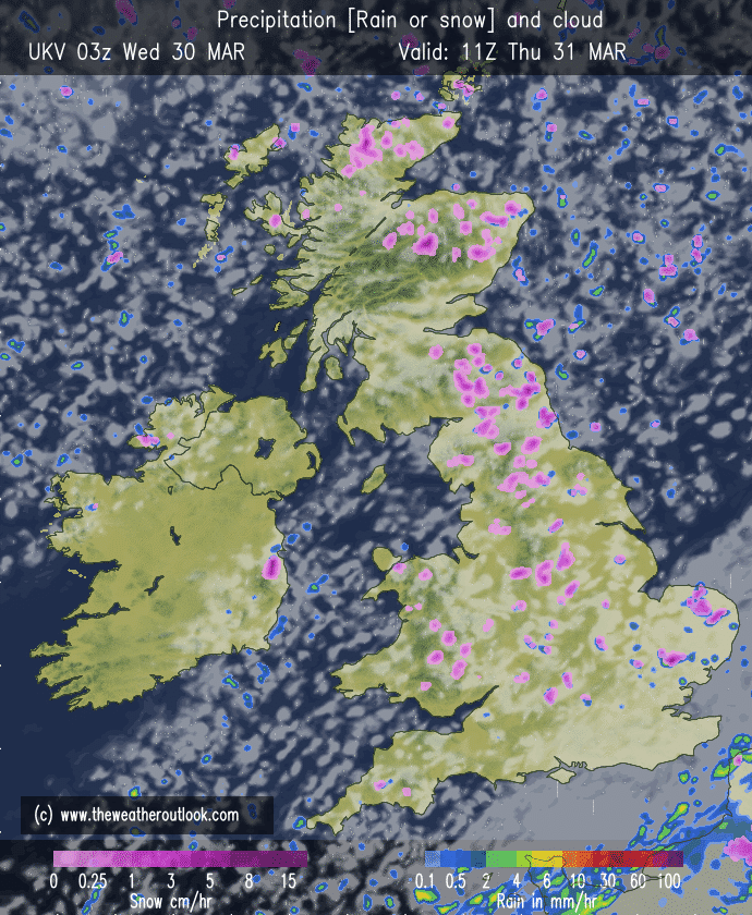
Thursday: A frosty and icy start with sunny spells developing. Wintry showers will feed in from the northeast during the day with fewer showers the further west you are. Showers will be of rain, sleet, hail and snow There will be a strong and gusty wind leading to a biting wind-chill. Max 7°C

Wintry showers could lead to a slight covering of snow in places, mostly the hills during Thursday.

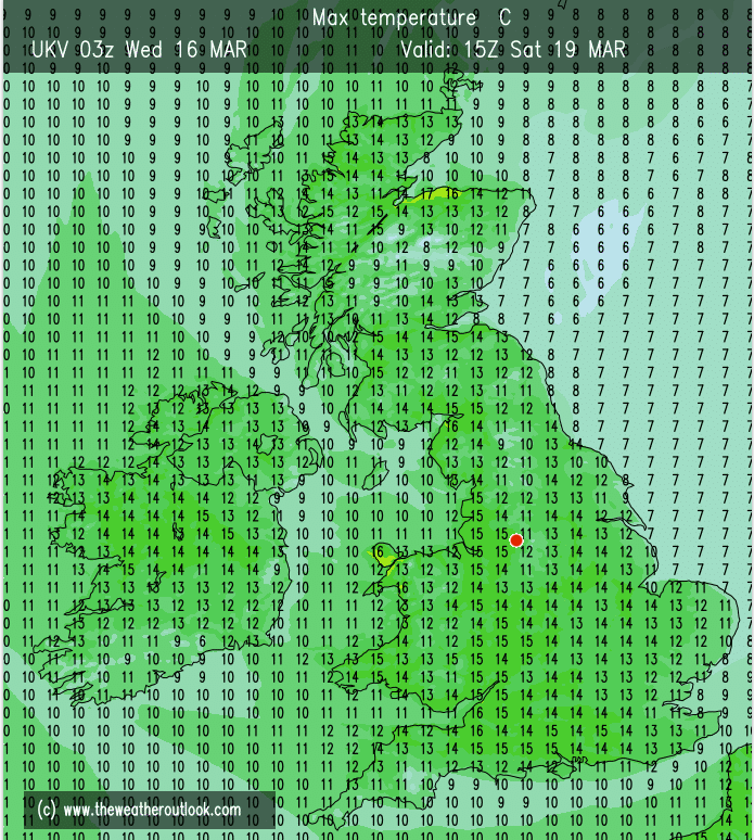
Friday: Again a frosty start then not a bad day with sunny spells and fewer wintry showers. The sun is gaining strength now so out of the breeze in shelter it won’t feel too bad despite the temperature. Max 7°C

Weekend: Less in the way of sunshine

Saturday: Cloud will spread down from the northwest bringing a few showers. Feeling cool with all the cloud during the morning but hopefully some brighter spells into the afternoon. Max 8°C

Sunday: Bright spells and a few showers. Tending to be a little drier into the afternoon with sunny spells developing. Max 9°C

Outlook: A westerly airflow will return bringing low pressure to the northwest of the UK. We will see some showery rain at times, but not a lot of rainfall is expected over the week. Temperatures will return to normal and the night-frosts will end.

Follow @ChadWeather on Twitter for the latest forecasts and warnings.

Thanks,
Jon

Forecast Issued: Wednesday the 30th of March 2022 at 5:07pm.
Image: http://www.theweatheroutlook.com

Enjoy the warmth before the temperature plummets – Thursday 24th March 2022 – Sunday 27th March 2022

Hi all,

What a superb spell of early-Spring weather we are experiencing and you need to fill your boots. Temperatures into the late-teens and plenty of sunny periods, but hazy due to the high pollution levels.

Everywhere is now beginning to dry out fast and after giving my garden its annual winter-is-over declutter, it was clear to see that it actually might need watering soon. With little rain on the horizon, it means after a soggy February, it will have been a very dry March.

Growers beware, temperatures are set to drop to below average values next week, a real shock for our gardens and plants after the warmth of this week.

UV levels are now creeping up and are around medium for a couple of hours at lunchtime. No sun-cream really needed yet, unless you’re out in it for several hours non-stop, late-morning to early-afternoon.

Thursday: Another cracking day. Warm to very warm for the time of year with widespread sunny spells. Some fair-weather cloud around. Light winds. Max 18°C

Friday: Continuing warm and sunny. Some cloud bubbling up into the day. Light winds. Max 18°C

Weekend: Grab that sunshine and make the most of it.

Saturday: Further sunny spells and warm with it too. Any morning-cloud burning off. Dry. Max 17°C

Sunday: Sunny spells but temperatures likely to be a notch or two lower. Max 15°C

Outlook: The high pressure that has dominated our weather will shift west and that move in location will allow more in the way of cloud to arrive. More importantly we will introduce a north-to-northeasterly airflow and at this time of the year that is still a very cold direction. Some of the air will be sourced from the Arctic. A lot of dry weather is still expected with the odd shower drifting in from the northeast. No snow expected, this will fall in the Scottish mountains though. By midweek we will see some ground-frosts return and daytime temperatures struggling to 7-9°C, a big change from this week.

Warmer than average this week to colder than average next week. Don’t put the big coats away just yet.

Follow @ChadWeather on Twitter for the latest forecasts and warnings.

Thanks,
Jon

Forecast Issued: Wednesday the 23rd of March 2022 at 9:13pm
Image: (chart) http://www.wxcharts.com

Welcome Spring Sunshine albeit Breezy – Thursday 17th March 2022 – Sunday 20th March 2022

Hi all,

Spring is here and the weather is finally responding. After an awful February, March is much drier (only 16mm so far) and we can now look forward to a drier, warmer and sunnier spell of weather.

Not quite our first 20°C of the year but it will feel very pleasant indeed over the coming days. Nights will be chilly with local ground-frosts and patchy fog. UV levels are approaching medium meaning you will begin to catch the sun’s rays if you’re out in it for a few hours. It won’t be long before you’re digging out the sun-cream.

A frosty start to Thursday.

Thursday: A cold start with a frost and patchy mist. Sunny spells for the morning then cloud will arrive into the afternoon with some scattered showers into the evening. Max 12°C

Friday: High pressure continues to build across the UK so a lovely day in prospect with plenty of sunshine after a chilly/frosty and in places foggy start. Some of the fog might be stubborn to clear and lift into low-cloud for a time. It will begin to feel warm in the sunshine. Max 14°C

Weekend: I normally say more rain but this time more sun. The only downside is that the breeze will pick up during the daytime which could become a little gusty.

High pressure in control for the weekend bringing the warmest day of the year so far, plenty of sunshine but quite a breeze too.

Saturday: Lots of pleasant Spring sunshine as we see the warmest day of the year so far. Max 16°C

Pleasant Saturday afternoon temperatures. Of course these are measured in the shade so feeling much warmer in the sunshine.

Sunday: Feeling warm under sunny skies. Just the chance of some cloud in the east later. Max 15°C

Outlook: The settled weather looks set to continue with high pressure mostly in charge. Just one hiccup could be a few showers on Monday afternoon. Lots of warm sunny spells and dry conditions with temperatures into the mid-teens. An easterly or southeasterly breeze could pick up later in the week pegging the temperatures back a little and dragging in some cloud at times from the North Sea but this all depends on the location of the high pressure.

The final weekend of March also looks fine and settled.

Follow @ChadWeather on Twitter for the latest forecasts and warnings.

Thanks.
Jon

Forecast Issued: Wednesday the 16th of March 2022 at 5:25pm
Images: http://www.wxcharts.com & http://www.theweatheroutlook.com

Some rain, mild and windy – Thursday 10th March 2022 – Sunday 13th March 2022

Hi all,

Temperatures are beginning to creep up but it’s hard to notice the change as we’ve had low pressure to our west and high pressure to our east battling it out, leading to a strong and gusty wind. Media reports were at it again this week, forecasting snow but there’s certainly none of that on the way.

Thursday: Breezy and mild with some bright spells here and there, best in the west. Chance of the odd rogue shower especially towards evening. A very mild night. Max 12°C

Friday: A mostly dry morning then bands of showery rain moving in. Windy, gusting 30-35mph, especially so later during hefty showers, perhaps thundery with hail. Max 12°C

Weekend: Some rain but bright spells at times.

Saturday: Sunny spells and few showers. Again, like most of the week, it will be windy. Max 12°C

Sunday: A little bit cooler and still windy with bright spells and showers at times which could be beefy. Max 10°C

Outlook: High pressure looks set to cut off the weather-fronts so a lot of dry weather with sunny spells with rain-bearing fronts staying away to the far north-west and south. Very mild early on, perhaps close to the mid-teens midweek. Some cool nights where skies clear with some patchy ground-frosts and mist and fog; more so later in the week.

Any weather-fronts next week weaken as high pressure squeezes from the SW and E.

Follow @ChadWeather on Twitter for the latest forecasts and weather warnings.

Thanks,
Jon

Forecast Issued: Wednesday the 9th of March 2022 at 6:55pm
Image: http://www.wxcharts.com

Meteorological Spring is here – Thursday 3rd March 2022 – Sunday 6th March 2022

Hi all,

I promised better conditions and in truth we’ve had some gloriously sunny days (Sunday and Tuesday) but we’re back into a cloudy and damp pattern at the moment and it’s certainly not as nice as I expected it to be. It had to improve though, I mean we had 3 named-storms in a week and a soggy February delivered a well-above-average rainfall stat of 187mm.

Winter ends with no proper cold or a taste of The Beast from the East. For cold-lovers it’s been another let-down. The set-up going into next week is quite interesting as low pressure out west looks set to battle with an established area of high pressure across eastern Europe.

Thursday: A cloudy day with the clouds thickening during the morning as rain pushes in from the west gradually. The afternoon will see further pulses of rain, occasionally heavy at times. Mild but breezy. Max 9°C

Friday: Morning drizzle or light rain will tend to ease and the day will remain cloudy but drier as it progresses. Lighter winds. Max 8°C

Weekend: Weakening weather-front.

Saturday: High pressure begins to build across the UK. Mostly cloudy with a weakening weather-front close to our east, which might produce some light rain or drizzle at times. Any sunshine to the west or north-west. Max 7°C

Sunday: Settled with mostly cloudy skies to start but sunny spells are expected to develop here and there especially to the west. A freshening breeze. Max 8°C

A massive high across eastern Europe keeps very cold air away from our shores

Outlook: Generally bright and mostly dry (chance of a few wintry showers on Tuesday) with a huge area of high pressure to our east introducing a chilly and gusty south-southeasterly wind. This is expected to last for a few days before the risk of rain returns towards next weekend.

A low out West, a high out East = a strong and gusty SSE’ly wind next week

Now we have officially entered Spring, weather-wise, I’m starting to look forward to that first warm spell but of course we still can’t discount cold snaps.

Looks like Atlantic weather-fronts return by next weekend, so rain and wind on the agenda.

February 2022 Stats

Max 12.6°C (16th)
Min -0.1°C (11th)
Av. 6.0°C
Wettest 41.4mm (20th)
Av. Humidity 86%
Av. Barometer 1012.2 hPa
Max Gust 47.2mph
Av. Wind Direction WSW
Rain 187mm (well above average)
Rain Registered Days 26
Dry Days 2 (Ouch!)
Air Frosts 1
Snow Falling Days 2

Follow @ChadWeather on Twitter for the latest forecasts and weather warnings.

Thanks,
Jon

Forecast Issued: Wednesday the 2nd of March 2022 at 8:45pm
Images: http://www.wxcharts.com