Thursday 27th October 2016 – Sunday 30th October 2016

Hi,

October is still on course to be an exceptionally dry month as it comes to an end with little rain to speak of.

With winter on the horizon, the talk (if you can call it that) has already started of “120 days of snow.” etc., etc. There are signs that this winter has a much better chance of being colder-than-average and hence increase the chance of snow, but as always, things can change.

If you would like more detail and not an over-the-top complex view of what our winter set-up could be like, then read my friend’s article, http://www.chorleyweather.com/weak-polar-vortex-could-bring-an-early-uk-winter/.

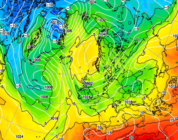
Currently, we have low pressure to our northwest and high pressure to our south, with us sandwiched in between. We now have a westerly flow so we are milder than recently.

Thursday: Quite cloudy with limited bright spells. Some passing drizzle or light rain possible at times especially on high ground. Breezy but mild. Max 14°C

Friday: Little change. Plenty of cloud and mild. Less of a breeze hopefully. Some localised drizzle but most places staying dry. Max 14°C

Saturday: A dry day with mostly cloudy conditions. Any early mist will lift. Light winds with high pressure close by. Max 13°C

Sunday: Rain could be pushing into western parts of the U.K. but we look to remain dry once again with mostly cloudy skies. Some brightness possible in eastern parts. Max 13°C

Slowly a change to a north or northwesterly airflow next week

Next Week: Not guaranteed but it’s looking more and more likely that winds will turn to come from a colder northerly or northwesterly direction as the week progresses. This will bring sunny spells, the odd shower and daytime temperatures in single-figures as well as possible frosty nights.

Our weather is always changing so keep up to date by following @ChadWeather on Twitter.

Thanks,
Jon

Image: http://www.netweather.tv
Forecast issued at 12:15pm on Wednesday 26th of October 2016

Thursday 20th October 2016 – Sunday 23rd October

Hi all,

I had a feeling the second half of October would be “rain-fuelled”. After a few days of rain you would think the same, but another blocking high pressure is set to dominate our weather which could give some overnight mist or fog as well as localised pockets of frost.

Thursday: A chilly start but a mainly dry day ahead with some sunny spells. Risk of a very isolated shower in the afternoon. Light winds. Max 13°C

Friday: Possibly a misty start, then bright spells developing, but some thicker cloud from the east at times just might produce a light shower. The general theme is for mainly dry conditions. Max 12°C

High pressure close by is set to dominate our weather again

Saturday: A cool easterly breeze starts to pick up during Saturday so feeling cooler. Another dry day though with bright spells after low-cloud to start. Max 11°C

Sunday: Little change from Saturday. Plenty of dry weather. Bright or sunny spells but a cold easterly wind. Max 11°C

Next Week: Low pressure to our southwest and high pressure to our northeast or east means we continue to be dry <October is turning out to be very dry indeed> and under the influence of a cool easterly airflow.

As always, follow @ChadWeather on Twitter for the very latest forecasts.

Thanks,
Jon

Forecast issued at 10:45am on Wednesday 19th October 2016
Images: http://www.ukweatherforecast.co.uk

Thursday 13th October 2016 -Sunday 16th October 2016

Hi all,

We’ve been under the influence of a huge area of high pressure based over Scandinavia for a good while now but finally things are about to change. If only we had had this set-up in winter.

Thursday: A cool easterly wind across the region which will blow in showers, some will be heavy. Limited bright spells in between. Feeling cold. Max 11°C

Friday: The change begins as low pressure starts to edge in from the south and west. Another cool day with some showers and we still keep that nagging easterly breeze although not as strong as yesterday. Max 12°C

We can’t complain about our weather so far in October. It’s slowly become cooler but we’ve hardly had any rain; only 1mm in fact.

showery

After a dry October so far; rain is set to return


Saturday: Low pressure anchored to our south-west feeding up a less cold southerly wind but also some spells of rain. This should turn more showery later with some sunny spells. Max 14°C

Sunday: Bright spells and showers. Still winds remain from the south so temperatures not too bad regardless of the conditions. Max 15°C

Next Week: Low pressure in charge so spells of rain but some brighter, drier interludes too. Temperatures close to average. I would expect the remainder of October to be rain-fuelled after the exceptionally dry start, but as always, long-range is anyone’s guess.

As always, follow @ChadWeather on Twitter for the very latest forecasts.

Thanks,
Jon

Forecast issued at 1pm on Wednesday 12th October 2016
Images: http://www.netweather.tv

Thursday 6th October 2016 – Sunday 9th October 2016

Hi all,

It’s been a decent start to autumn with most of us enjoying settled conditions and plenty of dry weather. This pattern is set to continue as high pressure to our northeast, acts as a block, stopping rain-bearing weather fronts coming in from the west.

cool-easterlies

High pressure to our NE introducing blocking leading to cool easterlies.

Thursday: Cool south-easterly winds across the region but it should remain dry with some bright spells. Max 13’C.

Friday: Not much change, plenty of cloud morning and night. Some bright spells will try to break through during the day. Still a cool breeze. Just a risk of some drizzle, early and late. Cool. Max 13’C.

Starting to feel like déjà vu. The weekend sees a lot of dry weather as the high pressure to the northeast stays put. Overall both days cool or even chilly in the breeze. Some welcome bright spells at times but these will come and go. See the sun and it will make it feel pleasant as long as you’re sheltered from the breeze. Max 13’C.

Next week: Little change until later in the week, when the Atlantic, disturbed by the recent events of Hurricane Matthew, might start to kick back into gear again. However, with this high pressure very stubborn to move, our dry settled cool weather could continue. For sure though, the first half of October looks set to be very dry.

September 2016 Stats

Max 23.7’C (13th)
Min 7.6’C (30th)
Wettest 21mm (13th)
Windiest 32mph (29th)
Rain 66.6mm
Rainy Days 17
Dry Days 13

As always, follow @ChadWeather on Twitter for the very latest forecasts.

Thanks,
Jon

Forecast issued at 2:15pm on Wednesday 5th October 2016
Images: http://www.netweather.tv