Thursday 19th October 2017 – Sunday 22nd October 2017

Hi all,

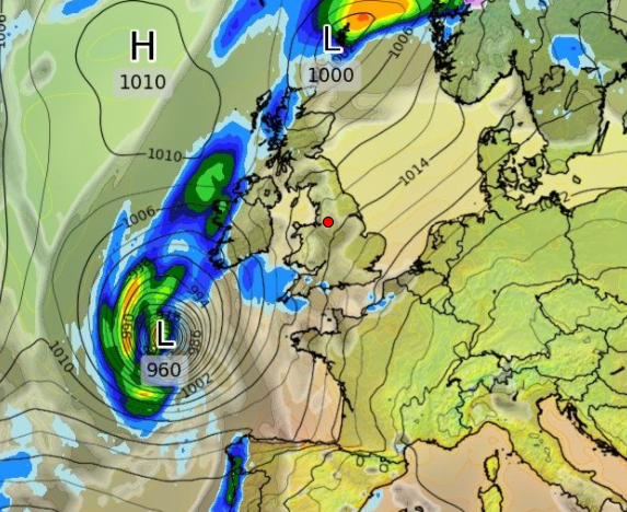
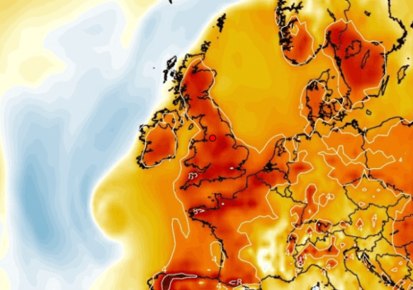
Autumn continues to live up to its name as we experienced some wild weather earlier this week. Ex-Hurricane Ophelia (Bizarre Storm) arrived as forecast but we escaped the worst. Chadderton recorded a 44mph gust but generally across the region it was 50-55mph with 70mph along the coast. What was unusual was it wasn’t hammering down with rain. Once morning-showers moved away, some lightning was recorded near Bury, then the day turned very strange indeed. I had noticed a weird ‘light’ on the way to work and soon the sky was filled with rolling cloud that looked very smoke-like and a glowing red sun. Ex-Ophelia’s southerly winds had pushed smoke particles from the Portuguese/Spanish wildfires and Saharan Sand northwards (Red Sun Phenomenon).

As you know we have named-storms and we are currently on ‘B’ as we had Aileen in September. The reason Ophelia wasn’t Brian was because she was already named and since she kept her strength, she remained named the same, even though an ex-Hurricane, as she arrived on our shores.

Storm Brian could well be here quicker than you think……

Thursday: A lot of cloud around but with some bright spells during the day after a misty start. With light winds it will feel pleasant and mild. However, the breeze will pick up later in the day with a risk of some showery rain developing especially to the south and east. Max 16°C

Friday: Fronts will arrive from the west, so a spell of rain which will be followed by brighter conditions and some showers. Breezy and fresher. Max 13°C

Weekend: Poor. Wet and very windy.

Brian

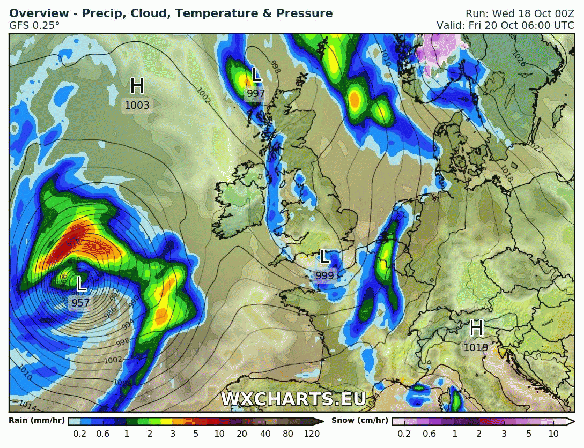
Storm Brian this weekend?


Saturday: A deep area of low pressure will have been forming out west on the Jet Stream and this system could well be named as Storm Brian. At the moment the strongest winds (70mph gusts) look to be heading to Southern Britain, but the track is still uncertain so watch tweets for updates. Currently, it will be a wet day with rain, heavy at times and windy with 40mph gusts. Feeling cold. Max 13°C

Sunday: The ‘storm’ will move into the North Sea but will introduce cold north-easterly winds and with it frequent showers which could be thundery. Remaining windy with gusts possible to 45mph during showers. Max 12°C

Outlook: Remaining unsettled with some spells of wind and rain broken up by some drier slots. Temperatures around or just above average.

Follow @Chadweather on Twitter to keep up to date with the local weather.

Thanks,
Jon

Forecast Issued: Wednesday the 18th of October 2017 at 1pm
Images: WXCHARTS – Follow them on Twitter.

Thursday 12th October 2017 – Sunday 15th October 2017

Hi all,

I’m back from a superb golfing holiday in Spain. If you missed the photos, the weather was amazing. Four days of 27-30°C and plenty of sunshine. Remind me again why I live in the UK. 😦 At least we will see some warmer air in time for the weekend.

Thursday: After a poor Wednesday, a much better day with plenty of sunny spells after a chilly start. Cloud will bubble up during the day but it will remain dry with lighter winds. Fresher. Max 15°C

Friday: That warmer air mass starts to arrive but with it rain at times on a keen southwesterly wind. There will be some drier slots. Muggy. Max 18°C

Weekend: Warm and not too much rain about.

Saturday: Generally cloudy with a risk of drizzle or light rain on coasts and hills to start. Hilltops could be misty or covered in low-cloud. As the day progresses it should dry up with some localised brightness and feeling warm for the time of year. Max 19°C

Sunday: Drier with bright spells at times. Still feeling warm with southerly winds especially in any sunshine. I have lots of BBQ food left…… hmmmmm. Max 19°C

Warmer 2

Ex-Hurricance Ophelia located to our southwest

Warmer 1

Above average temps: Warmer air ahead of ex-Hurricane Ophelia, cooler air behind it

Outlook: The remnants of Hurricane Ophelia, located to the southwest of the UK, may bring further warm air up from the south on Monday. With sunny spells on offer, temperatures could be close to 21°C. The rest of the coming days will be cooler and mostly cloudy before rain and wind returns.

Follow @ChadWeather on Twitter for the latest forecasts.

Thanks,
Jon

Forecast Issued at 6pm on Wednesday the 11th of October 2017

Thursday 28th September 2017 – Sunday 1st October 2017

Hi all,

After a mostly wet September the last third hasn’t be too bad with mild temperatures and drier conditions. It looks like the Jet Stream returns into October bringing more rain and also some windier conditions which could lead to Storm Brian.

Thursday: Early rain will clear to leave a reasonable day with sunny spells and it should remain dry. Max 17°C

Friday: Cloudy with another band of rain spreading west to east. It will clear into the afternoon with the odd shower to follow. Cooler. Max 16°C

Weekend: Saturday the better day of the two.

Saturday: Sunny spells and perhaps the odd shower. Feeling fresh. Max 15°C

Sunday: Rain, heavy at times arriving from the west and lasting most of the day. Looks like my golf competition could be a washout. Meh. Max 14°C

Outlook: Ex-hurricanes Maria and Lee, will influence our weather. It’s uncertain yet, after a spell of wind and rain (perhaps a named-storm), whether it settles down or remains wet. Time will tell as currently it could go either way.

One thing to note: the media and tabloids will have a field day but the predicted wet and windy weather for early October is nothing unusual as we tend to have our fair share of Autumnal storms.

Follow @ChadWeather for the latest weather forecasts.

Thanks,

Jon

Forecast issued on Wednesday the 27th of September 2017 at 6:15pm.

Thursday 14th September 2017 – Sunday 17th September 2017

Hi all,

Storm Aileen, our first named-storm of the season, certainly had the potential to deliver some strong gusts in excess of 60mph during the early hours of Wednesday, but failed to deliver. The track of the low was crucial and the path taken meant the stronger winds were located further south and southeast. I only recorded 33mph at 2:53am. The lowest pressure recorded was at 2:21am with a value of 984.19mb. Nothing unusual at all for Autumn.

Here’s the A-Z of named-storms from the Met Office.

Thursday: A day of sunshine and occasional showers which will arrive on a fresh, cool north-westerly wind. The showers should ease towards evening. Max 15°C

Friday: Little change with bright spells and showers. The breeze will be from the north so a chilly feel. Clear spells will lead to temperatures dipping into single figures. Max 14°C

Weekend: Improving slowly. Cool nights. 

Saturday: Plenty of cloud around with some bright spells. Some showers still likely, especially so in eastern areas. Max 15°C

Sunday: A cold start with perhaps a rural ground frost. Sunny spells developing and we should have killed off the showers so remaining dry. Max 15°C

Outlook: Not a bad start to next week. Dry with bright spells but showers are expected to return from midweek.

Follow @ChadWeather on Twitter for the latest forecasts across Manchester and its surrounding areas.

Thanks,
Jon 

Image: Met Office

Forecast Issued at 13:40 on Wednesday the 13th of September 2017

Thursday 17th August 2017 – Sunday 20th August 2017

Hi all,

I still have high hopes for it being a reasonable, or even decent last week of August. Fingers crossed.

Thursday: Any early morning cloud and rain clears quickly, to give a warmer day than recently, with sunshine and some showers. Catch one and it will be heavy but they will be well-scattered. Max 21°C

Friday: We swing back to unsettled conditions. Much cooler with frequent showers and quite windy. Max 16°C

Weekend: Sunshine and showers to start.

Saturday: Fresh northwesterly winds with sunshine and showers. These more likely during the morning with the afternoon and evening likely to be drier. Max 16°C

Sunday: A tricky forecast, as ex-Hurricane Gert, now a low pressure, will be sitting to the northwest of the UK. With it comes wind and rain, nothing major, although the rain will be heavy. Some uncertainty on how far southeast the rain will track, so this forecast could change. At the moment, bright spells to start but becoming windy with rain arriving from the west during the day. A little humid. Max 18°C

Outlook: The arrival of Gert will disturb the Jet Stream and hopefully this will lead to high pressure building into next week bringing settled conditions with more in the way of warm sunshine.

Follow @ChadWeather on Twitter for the very latest local forecasts.

Thanks,
Jon

Forecast Issued at 1:30pm on Wednesday the 16th of August 2017

Thursday 29th June 2017 – Sunday 2nd July 2017

Hi all,

Rain, rain and more rain fell on Wednesday making it one of the wettest June days I’ve recorded. The good news is the weather will improve in time for the weekend. 

Thursday: Cloudy with rain during the morning but it should be light and not as persistent as Wednesday. Slowly drier into the afternoon and a little warmer. Max 17°C

Friday: Generally cloudy again with some rain or showers at times. Breezy. Max 17°C

Weekend: An improvement but windy. 

Saturday: Sunny spells and mostly dry. Breezy especially later on and there will be some passing rain during the night. Max 17°C

Sunday: A fresh westerly wind but after any morning rain clears it should be dry with some bright spells. Max 16°C

Looking ahead: High pressure will try and push up from the south but not guaranteed to anchor itself over the UK. Overall a bit warmer and some drier slots with bright spells. 

Follow @ChadWeather on Twitter for further updates. 

Forecast Issued at 3:30pm on Wednesday the 28th of June 2017

Thanks,
Jon

Thursday 22nd June 2017 – Sunday 25th June 2017

Hi all,

After several days of very warm to hot weather and a risk of thunderstorms later on Wednesday, we’re finally back to more accustomed conditions.

Thursday: The humid air is now being pushed away to the east after yesterday’s showers cleared the air. A lot of cloud with some localised light rain or drizzle for the morning but it will tend to become a little brighter into the afternoon. Much cooler. Max 18°C

Friday: Cloudy with some rain at times, clearing later into the evening to bring some drier conditions and perhaps some brightness. A fresh westerly breeze. Max 17°C

Weekend: Bright spells and showers. Breezy.

Saturday: Bright spells and some showers with a noticeable breeze. I prefer this to the horrible humidity we experienced earlier in the week. Max 17°C

Sunday: Fewer showers, in fact some places dry with some brightness, and hopefully not as breezy as it was on Saturday. Risk of some rain late-evening and overnight. Temperatures around normal. Max 16°C

Outlook: Likely to turn more unsettled with showers and temperatures slipping just below normal.

Follow @ChadWeather on Twitter for the latest weather forecasts.

Thanks,
Jon

Forecast Issued at 12:30pm on Wednesday the 21st of June 2017

Thursday 15th June 2017 – Sunday 18th June 2017

Hi all,

After a few changeable days the weather warmed up again on Wednesday and the general theme over the weekend is for more summery temperatures to arrive.

Thursday: Yesterday’s warmth and humidity will be replaced by fresher air from the west. Cloudy with some isolated rain during the morning, moving west to east, followed by brighter skies and perhaps an afternoon or evening shower. Max 18°C

Friday: Generally cloudy, some brightness and mainly dry. A little breezy and temperatures around normal. Max 18°C

Weekend: Very warm sunny spells with variable cloud.

Saturday: A cloudy start is expected but some warm sunny spells will break through at times, especially later in the day. Some northwestern areas and along the west coast could remain cloudy all day. Remaining dry with a slight breeze. Max 22°C but localised sunnier spots could go a couple of degrees higher. 

Sunday: Sunny spells and very warm. It should remain dry again and pleasant. BBQ anyone? High UV levels. Lighter winds. Max 24°C

Outlook: A very warm start but fresher conditions following on from the west but it will remain generally settled with sunny spells and just a few showers. 

Follow @ChadWeather on Twitter for the latest weather forecasts. 

Thanks,
Jon

Forecast Issued: Wednesday 14th June 2017 at 14:10

Thursday 8th June 2017 – Sunday 11th June 2017

Hi all,

Welcome to Summer. LOL. It’s been feeling more like autumn this week as an unusually deep area of low pressure for the time of year brought gale-force gusts in exposed places and over 30mm of rain in 48 hours. Locally, in higher locations, 40mm was recorded as well as gusts to 57mph. Impressive stuff. 

Summer hasn’t started well after unusually windy weather earlier this week

Will the real summer be making an appearance soon? It doesn’t look like it as there’s no sign of any prolonged sunshine and heat in the next 7 days. 

Thursday: Cloudy and wet with rain at times. It’s going to be particularly heavy in the morning and slowly more showery into the afternoon. Some of the late-in-the-day showers could be thundery with hail. Feeling muggy. Max 17°C

Friday: An area of low pressure over the U.K. but it will be quite flabby so no issue with the strength of the wind. Sunny spells and showers the order of the day. Pleasant in any sunshine and the showers easing later. Max 18°C

Weekend: Sunday’s the best day

A wet start to the weekend


Saturday: A band of rain sweeps in quickly from the west followed by showers. Breezy at times. Max 18°C

Sunday: A better day and therefore feeling warmer. Bright spells and perhaps a few light showers. Max 18°C

Looking ahead: Breezy with sunshine and showers but midweek onwards should see the weather settle down as high pressure builds. At the end of the week and into the weekend it could start to warm up nicely with temperatures into the 20s.

Follow @ChadWeather on Twitter for the latest weather updates. 

Thanks,
Jon

Thursday 1st June 2017 – Sunday 4th June 2017

Hi all,

After a lovely Wednesday with plenty of sunshine what’s in store as we enter our meteorological Summer.

Thursday: A cloudy day with some brightness especially during the morning. We drag up air from the South so turning humid and muggy. Max 22°C

Friday: A muggy day. Cloud will thicken and rain, perhaps heavy and thundery, will arrive from the west. After a humid start it will slowly become fresher. Max 17°C

Saturday: Westerly winds back in charge so cooler and fresher but with some nice sunny spells and a few showers. Max 16°C

Sunday: Not much change. Sunshine and showers. Pleasant in any sunshine this weekend as the sun is strong as this time of the year. Max 16°C

Outlook: Low pressure to our north at times and high pressure to our south, so basically a sunshine and showers mixture. Perhaps breezy at times and temperatures around normal or just below with some cool nights.

As always the British weather is very changeable, so keep up-to-date with your local weather by following @ChadWeather on Twitter.

Thanks,
Jon

Forecast Issued: Wednesday the 31st of May 2017 at 2:20pm