Thursday 18th January 2018 – Sunday 21st January 2018

Hi all,

We are halfway through winter and we were reminded this week with snow returning to some parts as well as plenty of hail and some thundersnow. After last week’s dank slow-weather days we are back up and running with plenty to talk about. There is some more snow on the way.

Lightning 160118

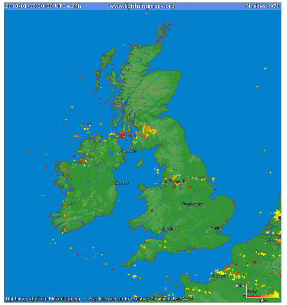
Lightning Strikes: Tuesday saw thunder and lightning, giving some of us thundersnow

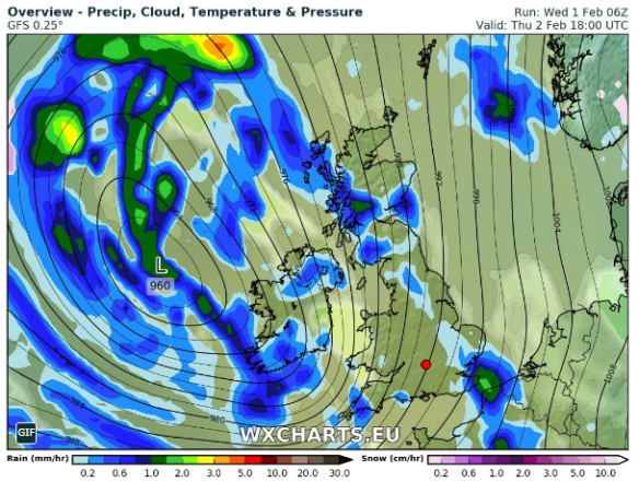
Thursday: The early hours and early morning will be very windy with 50-55mph gusts across the region as a low pressure moves through. The thinking was that this system would be named but it is now less intense and therefore hasn’t been christened. It will briefly become milder but during the morning winds will die down somewhat and it will become colder again. After all that we will see a day of sunshine and frequent thundery wintry showers which will fall as snow above 200M. Max 5°C

Snow showers on Friday

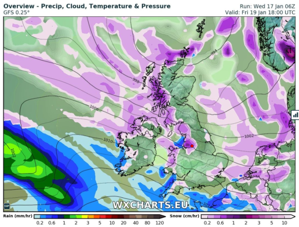
Wintry showers, including some snow, will be blown in again on Friday

Friday: A colder day and windy with more wintry showers feeding in. Again, these could be thundery with hail and snow. Snow showers expected almost anywhere but especially on higher ground where it is likely to settle. Max 3°C

Snow Depth cm by the end of Friday

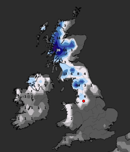
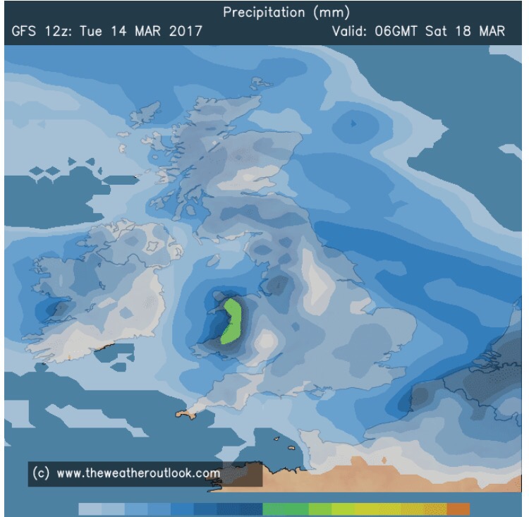
Predicted snow depth (cm) by the end of Friday

Weekend: Saturday’s the day!

Saturday: A frosty start with snow-cover in places from yesterday’s showers. However a decent day ahead. Dry with sunny spells and cold. A perfect winter’s day. Max 4°C

Sunday: A cold start and perhaps briefly dry. Rain (timings still uncertain at this stage) will then move in from the west preceeded by snow in places, especially on the hills and Pennines, but all areas seeing it turn to rain as it becomes slowly milder later. A thaw of any remaining lying snow. Max 7°C

Outlook: Temperatures average for the time of year but with our weather favouring coming in from the Atlantic, we can expect some spells of rain at times. Chilly nights with some patchy frost.

Follow @ChadWeather on Twitter for frequent weather updates.

Thanks,
Jon

Forecast issued: 10:15am on Wednesday the 17th of January 2018
Images: https://www.lightningmaps.org and http://wxcharts.eu 

Thursday 4th January 2018 – Sunday 7th January 2018

Hi all,

Happy New Year and all the best for 2018!

I hinted that we would end 2017 with a named-storm and in rolled Storm Dylan to be followed by Storm Eleanor yesterday. The Jet Stream has been in charge of our weather in recent days but it will split this weekend and high pressure will build. A northeasterly flow will develop and we will enter a much colder but drier spell of weather.

Thursday: Cloudy with rain for the morning turning showery into the afternoon as the rain band pushes slowly north. We are still in the mild air so temperatures just above average. Max 8°C

Friday: Cloudy with some showers. There will be a little bit of brightness too and as the day progresses, it will get colder. Max 4°C

Weekend: Dry and colder with a biting wind-chill.

Saturday: Cold and mostly dry with some bright spells and the chance of a wintry shower blown in on a freezing northeasterly wind. Widespread frost overnight. Max 4°C

Sunday: Dry with sunny spells after a frosty start. Less breezy, so a pleasant day to get out and about if you’re wrapped up well. Frost returning at night and if winds fall light enough perhaps some fog. Max 4°C

Outlook: High pressure will face a battle with fronts trying to push in from the Atlantic. It will remain cold with plenty of dry weather. Cloud will increase from the west with a risk of rain, preceded by snow, possibly pushing the high pressure away by midweek. If this happens it would turn milder but there’s a reasonable chance that we get ‘locked in’ to the cold for while. Look out for updates on Twitter.

Follow @ChadWeather on Twitter for your weather forecasts.

Thanks,

Jon

Forecast issued at 3:45pm on Wednesday January 3rd 2018

Thursday 23rd of November 2017 – Sunday 26th November 2017

Hi all,

Well hello weather, we welcomed back our typical Autumn this week, with an inch of rain falling in the first few days. We’ve also had a bit more snow-talk on the grapevine and this time there is some truth in the rumours. No no, don’t get your sledges out just yet, just be ready for a cold weekend with a risk of wintry showers.

Thursday: A mild start with some bright spells but showers will start to appear as the day progresses. Remaining windy and slowly becoming colder. Max 9°C

Friday: A better day and hopefully we will escape with a dry one with sunny spells. It will feel colder again with temperatures really struggling, leading to a slight frost overnight. Max 6°C

Weekend: Cold and breezy with wintry showers and some night-time frosts.

Wintry Showers

Wintry showers, some falling as snow especially on Saturday

Saturday: A bitter day with some bright spells and wintry showers which will could fall as hail or sleet. Some snow showers are possible, in any heavier bursts and certainly more likely on higher ground. Max 5°C

Sunday: More in the way of sunshine with a few wintry showers left over, but there shouldn’t be as many as Saturday. Still cold, especially with the freshening breeze ahead of rain due late-evening and overnight. Max 6°C

Outlook: A touch milder with some rain but then it seems the colder air returns and with it the risk of wintry showers and overnight frosts.

Follow @ChadWeather on Twitter for the latest forecasts.

Thanks,
Jon

Forecast Issued on Wednesday 22nd of November 2017 at 11:35am.
Image: http://wxcharts.eu/

Thursday 7th September 2017 – Sunday 10th September 2017

Hi all,

Summer has been and gone (meteorologically speaking of course). Did anyone see it arrive? I remember June being quite settled late on and quite warm which ran on a little into July. August was very disappointing and the coolest summer month.

Av. Max. Temps

June 18.2°C
July 19.0°C
August 17.8°C

Av. Temps

June 15.0°C
July 15.4°C
August 14.5°C

Thursday: Bright spells, but with the general theme of cloud thickening during the day and the breeze will pick up. Rain arriving during the afternoon. Max 17°C

Friday: A lively day with plenty of showers, maybe thundery, and windy. Feeling cooler. Max 14°C

Weekend: Cool, showery and feeling autumnal.

Saturday: A breezy day with showers feeding in on a northwesterly wind. Cool. Max 14°C

Sunday: Showers will continue but with it some bright spells. Little change in the feel to the weather. Becoming windy into Monday. Max 15°C

Late Sunday

An unsettled weekend ending with the wind picking up & another low pressure

Outlook: Remaining unsettled with low pressure in charge bringing spells of rain or showers. Just a glimpse of something drier towards the end of next week.

Aug 2017 Stats

Max 22.8°C (shocker)
Min 7.7°C
Wettest 10.4mm
Windiest 32mph
Rain 58.2mm (drier than average)
Rainy Days 20 (grim)
Dry Days 11

Follow @ChadWeather on Twitter for the very latest forecast for your area.

Thanks,
Jon

Forecast Issued at 4:20pm on Wednesday the 6th of September 2017

Thursday 29th June 2017 – Sunday 2nd July 2017

Hi all,

Rain, rain and more rain fell on Wednesday making it one of the wettest June days I’ve recorded. The good news is the weather will improve in time for the weekend. 

Thursday: Cloudy with rain during the morning but it should be light and not as persistent as Wednesday. Slowly drier into the afternoon and a little warmer. Max 17°C

Friday: Generally cloudy again with some rain or showers at times. Breezy. Max 17°C

Weekend: An improvement but windy. 

Saturday: Sunny spells and mostly dry. Breezy especially later on and there will be some passing rain during the night. Max 17°C

Sunday: A fresh westerly wind but after any morning rain clears it should be dry with some bright spells. Max 16°C

Looking ahead: High pressure will try and push up from the south but not guaranteed to anchor itself over the UK. Overall a bit warmer and some drier slots with bright spells. 

Follow @ChadWeather on Twitter for further updates. 

Forecast Issued at 3:30pm on Wednesday the 28th of June 2017

Thanks,
Jon

Thursday 16th March 2017 – Sunday 19th March 2017

Hi all,

Halfway through March and no sign of a late-winter chill or snowfall just yet. However, after a reasonably bright and mild few days, it will be cooler and wetter towards and over the weekend.

Thursday: High pressure slips away into Europe allowing a weak weather front to come in from the west. A cloudy day with some rain, especially on higher ground and later in the afternoon. Breezy. Max 11°C

Friday: The Atlantic influences our weather over the coming days. Another cloudy one on Friday with rain at times spreading in from the west on a freshening wind making it feel much cooler. Max 8°C

Little change into the weekend.

A windy Saturday & Sunday with 35-40mph gusts

Saturday: Early rain clears then sunny spells and showers. It will be cool and quite windy at times with 35mph gusts. A little milder but not that noticeable. Max 10°C

A wet weekend at times – not very Spring-like

Sunday: Cloudy with some more rain at times and again a brisk, westerly wind possibly gusting to 40mph. Max 12°C

Looking ahead: A little cooler with rain easing away to give some drier and more settled days but with some chilly nights.

Follow @ChadWeather on Twitter for the latest forecasts.

Thanks,
Jon

Forecast Issued: Wednesday the 15th of March 2017 at 11am
Images: www.theweatheroutlook.com

Thursday 23rd February 2017 – Sunday 26th February 2017

Hi all,

The final blog of winter 16/17 and what a disappointment it has been, when it comes to proper cold and snow. However, even though March is classed as Spring, I expect it will throw some cold spells at us with some snow before we feel the Spring warmth that we’ve all been waiting for.

Before all that, Storm Doris, and with her, an AMBER weather warning which is not that common, even during winter. The storm is yet to form. It will be developing quickly as it approaches and crosses the UK. At the time of publishing these are the warnings: Yellow and Amber Weather Warnings.

warning-areas

The warning areas – we just sit in the AMBER area


Thursday: Be aware that there could be disruptive weather with some structural damage. The day will dawn quite ‘calm’ with what’s to come, with some rain moving in from the west. The rain will become heavy and from mid-morning the winds will increase quickly. Widely we can expect gusts to 50mph. There will be a spell of windier conditions, where we could locally see 60mph gusts and perhaps up to 80mph in exposed places. These gusts are strong enough to damage property and uproot trees. The strongest gusts are expected to be between 11am-3pm but times may vary so watch out for updates on Twitter. As the storm moves through, the winds will turn northwesterly and introduce colder air, so don’t be surprised to see some sleet or snow from mid-afternoon onwards. This is more likely to fall on higher ground (above 300M) and on the Pennines where there will be a few inches. Although it will become less windy into the evening, we can still expect gusts to 40mph. Overnight, further wintry showers with possible hail and feeling colder. Max 9°C which will be during the morning.


snow

Storm Doris will bring a lot of snow to Southern Scotland and Northern England


Friday: A much quieter day. Once you have found your garden furniture, we can expect some showers early on but then drying up and remaining mostly cloudy with less wind. Further rain overnight. Max 6°C

Saturday: Early rain will move through but some blustery showers will follow on behind. Another spell of windy weather with gusts to 35-40mph. Milder. Max 10°C

Sunday: It should be a fine start with some bright spells. Cloud thickening later on as another low pressure comes in with some rain and breezy conditions. Max 9°C

Looking ahead: Next week will start cooler with some showers. The rest of the week will see it slowly turn milder as the weather settles down. Drier conditions favourable but a lot of cloud once more. Let’s hope March sees a decent snowfall before we close the door on Winter 16/17.

Cheers,
Jon

Images: http://wxcharts.eu; http://www.netweather.tv; http://www.metoffice.gov.uk.

Forecast Issued: Wednesday the 22nd of February at 12:00pm


Thursday 2nd February 2017 – Sunday 5th February 2017

Hi all,

As we enter February our weather looks to turn wet and windy with a chance of the next named-storm; Storm Doris affecting some parts of the UK.

windy-on-thursday-and-friday

Low pressure in charge Thursday & Friday

Thursday: Low pressure arrives from the southwest so expect it to turn wet and windy with pulses of rain. Some drier slots. Gusts to 40mph likely especially later. Mild throughout. Max 11°C

Friday: A brighter start with some sunshine. Now there is some uncertainty about this but another low pressure could track in from the southwest with the potential for some strong winds with gusts up to 50mph. A warning was issued but now has been cancelled as the low is likely to track futher south. So the thinking is, bright spells and drier during the day, winds increasing later with some rain into the evening. Max 9°C

Cooler over the weekend but any frost limited.

Saturday: Cooler with some showers. Not as windy as recently. Max 6°C

Sunday:  A chilly day with a few scattered showers but in between weather systems means we should have a reasonable day with some bright spells as well. Max 6°C

wintry-showers

Colder with wintry showers midweek next week?

Looking ahead: Rain arriving later on Monday then midweek a chance of wintry showers and colder air from the East to finish the week. Finally some proper cold and snowfall?

cold-air-from-the-east-gif

Proper winter cold from the East arriving later next week?

January 2017 Stats

Max 9.9°C (11th)
Min -2.7°C (5th)
Wettest 12.8mm (15th)
Windiest 41mph (11th)
Rain 82mm
Rainy Days 23
Dry Days 8
Air Frosts Days 7
Snow Falling Days 3
Snow Lying Days 2

Follow @ChadWeather on Twitter to keep up to date with your local weather.

Thanks,
Jon

Forecast Issued on Wednesday the 1st of February 2017 at 12:15
Images: http://wxcharts.eu/

Thursday 12th January 2017 – Sunday 15th January 2017

Hi all,

Headline: Colder with snow for some of us.

Thursday: A very cold northwesterly wind in place which will bring some rain, hail, sleet & snow showers. Some of the snow will settle leading to tricky driving conditions with some ice later but this is expected to be in areas that are above 225M. You can reference the local elevation map or use the link to see what height you are above sea level. Max 3°C but feeling sub-zero in the wind.

wintry-showers-on-thursday

A bitter Thursday with rain, hail, sleet and snow showers in the mix. Snow settled above 200-250M

Use this link to see exactly how many metres you are above sea levelhttp://www.altitude.nu/ or for local locations see the image below.

heights-above-sea-level

Local locations with their height above sea level

Friday: Windy again with a brisk northerly airflow. Some more wintry showers around but they should be less frequent than what we saw on Thursday. Sunny spells in between the showers. Feeling very cold. Sharp frost overnight. Max 3°C

Saturday: Apart from the odd wintry shower, it looks mostly dry with sunny spells and a cold northerly or northwesterly breeze after a frosty start. It will turn frosty again later in the evening but it is likely to cloud over by morning.  Max 3°C

milder-from-the-nw

Milder air comes in from the NW during Sunday recovering temperatures

Sunday: There is still uncertainty about today but it seems that rain will topple in from the northwest which might, initially, fall as sleet or wet-snow on the higher routes. This weather front will also bring milder temperatures.  Max 6°C

Looking ahead: Mild initially but turning slowly colder from midweek with a chance of a cold easterly feed being established.

Keep up to date via my Twitter account, @ChadWeather.

Thanks,
Jon

Images: http://www.chorleyweather.com/, http://ukweatherforecast.co.uk and Oldham Council.

Forecast issued at 16:30 on the 11th of January 2017.


Thursday 17th November 2016 – Sunday 20th November 2016

Hi all,

A bit of a late posting today, but I’m finally here with the usual weekly outlook on what our weather’s going to throw at us. It’s certainly not going to disappoint this week.

Thursday: Cold and windy. Showers of rain and possibly hail and thunder. Some sleet for the hills. There is a chance of more prolonged rain during the morning. 6°C

**There is a possibility that wintry showers will merge together to bring a spell of sleet or snow overnight on Thursday, especially above 200M. One to keep an eye on via my tweets**

Possibilities of some localised sleet and snow overnight Thursday and into Friday morning. Above 200M most at risk.

Friday: Possibly a wintry start as mentioned, then feeling quite bitter with a stiff northwesterly wind and some wintry showers. Sunny spells during the day mixed in with those showers. Showers dying away overnight leading to a frost. 5°C

Heavy rain arrives on Sunday, preceded by Pennine-snow?

Saturday: Frosty start, then a typical pleasant, autumnal day. Sunny spells, just the odd wintry shower but with lighter winds it won’t feel as cold as previous days. 6°C

Sunday: Another cold start with a touch of frost. Cloud soon thickening and the wind increasing as heavy rain, possibly preceded by hill-snow for a time, moves in from the south-west. There is a good deal of uncertainty about how strong the winds could be and how heavy the rain will be so keep your eyes on my tweets. A cold raw feeling day. 7°C

Looking ahead and it’s set to stay cold with unsettled conditions close by. 

Keep up to date with your local weather by following @ChadWeather on Twitter.

Cheers,

Jon

Images: http://www.netweather.tv

Forecast issued Wednesday 16th November at 18:30.