Reasonable weekend but a poor outlook – Thursday 29th July 2021 – Sunday 1st August 2021

Hi all,

After the heatwave came the thunderstorms and now much cooler and unsettled conditions are in charge; all thanks to low pressure. Some media report the heat to return soon, but we all know that is guesswork. Nothing on the horizon at this stage to suggest sunnier, summery and hot weather returns.

Thursday: Any morning showers easing to some bright spells and a drier slot. Showers or patchy rain developing into the afternoon, especially to the north but not as lively as Wednesday with thunderstorms unlikely. Feeling cool & windy with 30mph gusts. Max 17°C

Temperatures much cooler than what we have been used to over the last few weeks

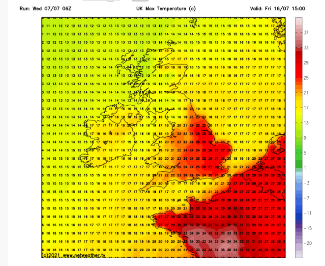
Friday: Some unusual weather for the time of year, strong to gale-force winds and heavy rain, will affect southern parts of the UK but we escape that. Otherwise it’s a day of scattered showers, some heavy and perhaps thundery. Some bright spells in between and a little less cool. Max 19°C

Weekend: Showers slowly decreasing in numbers but not disappearing.

Showers still around this weekend but the heaviest and thundery ones confined to the S & E of the UK

Saturday: Cloudy with a few bright spells. Showers are on the decline but I’m sure we will still catch a few today. Breezy but reasonably warm in any sunshine. Max 20°C

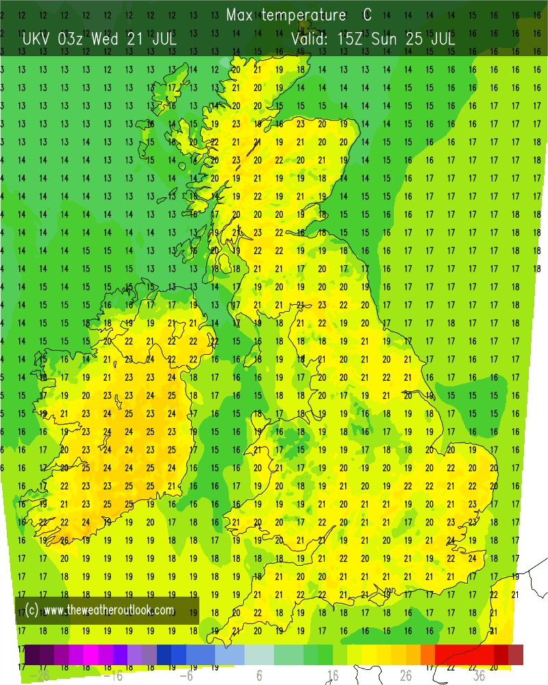
Sunday: A little cooler but a similar day. Plenty of cloud, some brightness at times and still the chance of a shower, especially towards the hills. Max 18°C

Outlook: A slight ridge of high pressure will mean Monday should be dry with pleasant sunny spells. Tuesday mostly cloudy but rain later and then the remainder of the week doesn’t look very summer-like at all, with the weather turning unsettled with showers or longer spells of rain. Temperatures remaining cool at times and the potential for a wet and windy weekend.

Early indications show it’s wet and windy next weekend

As always, look out for updates on Twitter, @ChadWeather.

Thanks for reading,
Jon

Forecast Issued: Wednesday the 28th of July 2021 at 8:45pm
Images: http://www.weatheronline.co.uk; https://www.netweather.tv/

Heatwave Departs – Thursday 22nd July 2021 – Sunday 25th July 2021

Hi all,

Yep, I know it’s too hot. 27-28°C wouldn’t be too bad if it wasn’t so humid and muggy and with dew points up around 17-18°C it’s been too much for me. So I’m happy to know it’s coming to an end but as always, with the British Weather, I’ll be moaning about how poor it is within days. Standard.

HEATWAVE: Here are the maximum temperatures I have recorded so far during this hot spell with the overnight lows too.

17th July 27.2°C : 15.0°C
18th July 26.7°C : 15.4°C
19th July 26.7°C : 15.7°C
20th July 27.0°C : 16.7°C
21st July 27.6°C : 16.4°C

Thursday: Hot with plenty of sunshine, perhaps a little hazy at times. Light winds and muggy. Low risk of an isolated thunderstorm. Looks set to be the hottest day of the heatwave. Max 30°C

Friday: Very warm to hot with sunny spells, but temperatures will be lower. There will also be a noticeable, and welcome breeze from the east. Max 26°C

Weekend: Turning unsettled & less hot.

Low pressure returns to influence our weather, especially on Sunday

Saturday: Cloudy with showery rain slowly pushing up from the south. Some of these showers could be thundery later in the day. Still quite humid but much lower temperatures. Max 20°C

Sunday: Quite muggy with bright spells and beefy showers developing, with some strong thunderstorms possible (look out for warnings). Welcome rain after the baking of last week. Max 21°C

Temperatures back to normal this weekend and these are the maximums we can expect for most of next week

Outlook: Our weather will return to what we are used to in a British Summer. Unsettled with showers at times and temperatures back to average, hovering around the 20°C mark. Odd thundery downpour possible too.

Follow @ChadWeather on Twitter for the latest forecasts. If you like reading my weekly blog then give the tweet a RT and hopefully this 4-day outlook can help others plan their day.

Thanks,
Jon

Forecast Issued: Wednesday the 21st of July 2021 at 7:05pm.
Images: http://www.wxcharts.com and http://www.theweatheroutlook.com

Heatwave time – Thursday 14th July 2021 – Sunday 17th July 2021

Hi all,

Our best weather of the summer is on the way, if you like it hot that is. High pressure is building in from the Azores and will dominate our weather for the coming week. So, the forecast doesn’t get much easier than this.

Don’t forget your sun-cream throughout. Be protected. UV levels are high (7) and you will catch the sun easily, especially so between 11-3.

Thursday: A cloudy morning with some brightness. Sunny spells developing during the day as cloud thins and breaks. Warmer than Wednesday. Max 24°C

Friday: Some early mist then a very warm day with sunny spells. Max 25°C

Weekend: BBQs, paddling pools, ice-pops and beers!

Saturday: Feeling hot with plenty of sunshine. Max 26°C

Sunday: Another cracking day with sunny skies and hot temperatures. Max 27°C (locally 29°C can’t be ruled out)

Outlook: Monday to Wednesday will remain sunny, dry and very warm but possibly a couple of degrees coming off the temperature. Signs are there that the weather will break later in the week, but at this stage details are uncertain so look out for updates on Twitter.

Follow @ChadWeather on Twitter for the latest forecast.

Thanks,

Jon

Forecast Issued on Wednesday the 14th of July 2021 at 9:40pm.

Summer on the horizon? – Thursday 8th July 2021 – Sunday 11th July 2021

Hi all,

It’s been a wet and muggy start to July after a very dry June. Plenty of rain this week was welcome for the gardens and golf courses but what we really want is some summer-warmth and sunshine to return – I need my BBQ fix.

Moody skies from my walk above Hanging Lees Reservoir on Wednesday morning

****Don’t forget UV levels are still high when the sun is shining.****

Thursday: A ridge of high pressure will begin to build from the southwest improving the weather. Dry with sunny spells. Chance of a shower in southern parts. Max 20°C

Friday: Similar day. Plenty of dry weather, bright or sunny spells during the morning with cloud bubbling as the day progresses. Low risk of a shower, more so the further east you are. Max 21°C

Weekend: Showers to return.

Saturday: A dry morning is expected with sunny spells and the odd rogue shower. Further showers brewing from lunchtime, locally heavy but these should be well-scattered and tend to ease towards evening. Not everyone catching one. Still warm with light winds. Max 21°C

Showers return this weekend after a drier couple of days

Sunday: Sunny spells for the morning. Any sunshine becoming hazy as the afternoon turns mostly cloudy with patchy, showery rain coming in from the west. Quite humid with light winds. Max 21°C

Outlook: After an unsettled few days, with showers continuing, it looks like high pressure will attempt to move in from midweek; well at least build in from the southwest with the ideal of taking hold. Sunny spells increasing and temperatures rising quickly, perhaps the mid-20s by the second half of next week. Fingers crossed. As always, with long-range forecasts they are not set in stone, so keep up-to-date on Twitter.

Temperatures set to rise later next week
High pressure tries to build in later next week but it could take its time

June 2021 Stats:

Max 24.1°C (2nd)
Min 6.8°C (22nd)
Av. 15.2°C
Av. Dew Pt 10.2°C
Wettest 3.8mm (25th)
Av. Humidity 73%
Av. Barometer 1019.8 hPa
Max Gust 27.6mph (3rd)
Av. Wind Direction NNW
Rain 9.8mm
Rain Registered Days 5
Dry Days 25

Follow @ChadWeather on Twitter for the latest forecasts.

Thanks,
Jon

Forecast Issued: Wednesday the 7th of July 2021 at 16:35
Images: http://www.netweather.tv and http://www.meteociel.fr