Colder Weekend – Thursday 28th January 2021 – Sunday 31st January 2021

Hi all,

It’s been another week of some snowfall and the count of ‘falling-snow days’ is increasing and certainly higher than recent winters. That said, no significant cold is yet to arrive from the east.

Thursday: Overnight rain will move away to the north-east during the morning. A mild start and it will stay that way with the afternoon becoming drier and perhaps with some brightness. Further rain later in the evening. Max 9°C

Friday: Rain becoming showery. Still mild and breezy. Max 8°C

Weekend: Colder.

Saturday: Winds will have swung to more of a north-easterly direction introducing colder air. Overall a better day with some sunny spells and generally dry (low risk of a low pressure developing out west and coming across the region – at this stage it looks like it will slip to the south of us, even into France). Frosty overnight. Max 5°C

Sunday: Frosty and cold with any clear spells fading to cloudy skies. Dry apart from some hill-snow flurries, then overnight or into Monday, rain will push in from the Atlantic, preceded by snow in places, especially above 250M. Max 4°C

Outlook: Slowly milder again next week with some showers at times. Signs of the cold returning towards the end of the week but, at this stage, certainly no signs of the Beast from the East.

Follow @ChadWeather on Twitter for the latest forecasts.

Thanks,
Jon

Forecast Issued: Wednesday the 27th of January 2021 at 5:35pm

The cold and some snow set to return after Storm Christoph leaves flooding in its wake – Thursday 21st January 2021 – Sunday 24th January 2021

Hi all,

What a week. Rain, rain and more rain and also some mild temperatures which we haven’t seen for a while. Locally (but not at my weather-station) we reached double-figures for the first time in a month. Storm Christoph, so far, has delivered around 3 inches of rain to most places, with higher amounts being recorded in the hills. Flooding reported widely and more to come as the hills empty their load into the rivers. This storm triggered a couple of weather warnings, including an Amber one, something we don’t see too often. It will be interesting to see the final rainfall amounts come Thursday.

Total rainfall amounts for Tuesday the 19th of January as Storm Christoph began its journey across the UK

Thursday: First off on Wednesday night; Storm Christoph will have deepened and pushed away into the North Sea. As the process takes place we will have some windy weather for a time and the winds will switch to a north-westerly and much colder air will dig in. As this does so, some of the legacy rain will turn to snow, chiefly on the hills, then all of us will see a blustery day with wintry showers as the mercury drops. Icy stretches morning and night and where snow settles in the heavier showers (mostly above 250M) Max 4°C Min 0°C

Friday: Frosty start. Sunny spells and a few wintry showers feeding in from the Irish Sea. Feeling cold. Max 5°C Min -1°C

Colder air from the NW with wintry showers feeding in across the region for the next few days

Weekend: Cold with wintry showers.

Saturday: Cold and mostly cloudy with some scattered sleet and snow showers from the north-west. A frost early and late with a few mist patches. Max 3°C Min -2°C

Sunday: Little change. Isolated wintry showers with snow settling on higher ground. Max 3°C Min -1°C

Outlook: A settled day on Monday with sunny spells after a frost. Heavy rain looks set to arrive on Tuesday preceded by snow on its leading edge as it bumps into the colder air. Again, this looks likely to be more so for areas above 250M. Milder air follows then a few days of cloudy conditions and showers.

For the latest forecasts follow on Twitter; @ChadWeather.

Thanks for reading,
Jon

Forecast Issued: Wednesday the 20th of January 2021 at 7:45pm
Images: http://www.netweather.tv/ & http://www.wxcharts.com/

Cold and wet spells; some snow – Thursday 14th January 2021 – Sunday 17th January 2021

Hi all,

We are back to the heavy rain but it’s not as mild as we would normally expect it to be and with this comes the chance of some hill-snow.

Thursday:  Heavy rain with a risk of some sleet or snow above 250M as the low pressure sinks south. Any precipitation easing as the weather front weakens later in the day. Cold. Max 3°C

As colder air arrives during Thursday, there’s a chance of seeing some snow.

Friday: Rain, sleet and any snow will have eased away and we’re in a bit of a lull. Mostly cloudy with hill-fog and low-cloud. Early ice. Cold. Max 2°C

Weekend: Unsettled to start.

Saturday: Rain swings in from the west again and the wind will increase. As this rain bumps into the colder air there could well be some snow for a time, even to low-levels (warning in place). Milder later. Max 7°C

Sunday: I’m hopeful for a drier day as morning rain dies away leading to some bright spells and the odd isolated shower. Cool. Max 6°C

Outlook: Colder weather seems likely to return but not until after midweek with little change before then. As for the Beast From the East; time will tell but the ingredients are brewing. 

Thanks,
Jon

Forecast Issued: Wednesday the 13th of January 2021 at 8:25pm

Image: http://www.netweather.tv

Cold snap to end – Thursday 7th January 2021 – Sunday 10th January 2021

Hi all,

Happy New Year to you all and I hope you all have a fantastic 2021.

It’s been a cold Christmas and New Year break with below-average temperatures across the region. There’s not been any widespread disruptive snowfall yet but we’ve kept the wintry showers going since the few cms of snow we had after Christmas. The white snow-covered hills have certainly made for some lovely walks and picturesque photos. Thanks to everyone for their wintry tweets.

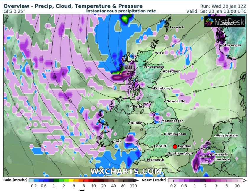
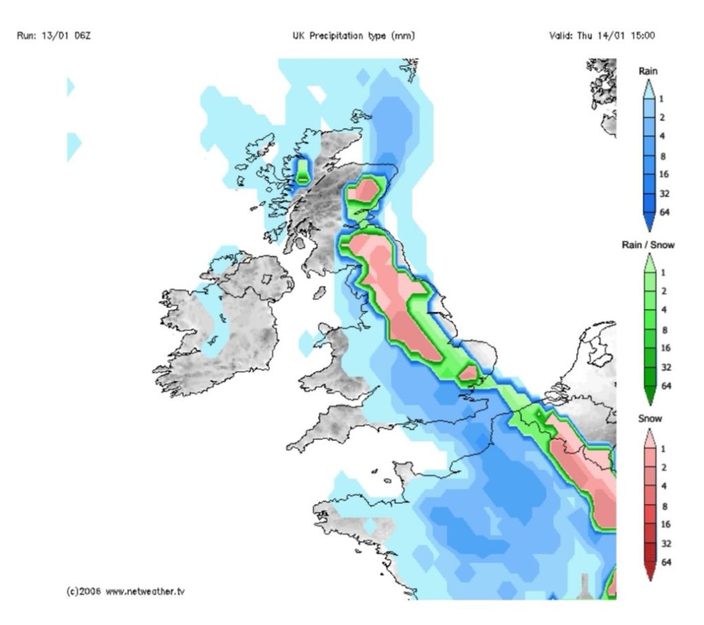
Thursday: A bitterly cold start with temperatures locally down to -6°C. So a widespread frost and icy patches after recent wintry showers. There will also be some freezing fog to watch out for. It will be a cold day and after a sunny start, away from the fog, it will cloud over from the North. A band of weakening precipitation will bring some patchy rain, sleet and snow to the region later in the day and overnight. A covering of snow can’t be ruled out even to lower-levels. Max 2°C Min -1°C

⚠️ Weather warning in place for ice and snow: https://twitter.com/ChadWeather/status/1346789217419079680?s=19

Friday: There will be some scattered sleet and snow showers around to start the day, again a covering is possible but nothing major. These will ease during the morning and it will turn brighter. A very cold day throughout with ice and overnight frost. Max 2°C Min -4°C

Weekend: Saturday the better day but change is coming…

Saturday: Another frosty start with plenty of ice. A nice day ahead with sunny spells but cloudier into the evening with a change in wind direction as less cold weather looms. Max 3°C Min -1°C

Sunday: More of a westerly airflow now introducing thicker cloud but starting dry after a patchy frost. Cloud thickening later with some drizzle possible. Max 4°C Min 2°C

Outlook: Temperatures continuing to rise back up to normal January values. Plenty of cloud with some light rain or drizzle at times. Will the colder (or even colder) weather return? As you may have heard in the news we have had an SSW event this winter so we have a 70% chance of colder-than-normal conditions (usually via an easterly wind) developing over the coming weeks. This is not certain and at this stage not showing on the horizon. More of an SSW explainer, keeping it simple, here: https://blog.metoffice.gov.uk/2021/01/05/new-year-begins-with-a-sudden-stratospheric-warming/.

Here are a few statistics for last month and the year of 2020 in general.

The days in 2020 with the most rainfall were SATURDAY & SUNDAY!

WEDNESDAY was the day with the most rainy days!

The average temperature for 2020 was 10°C.

The average maximum temperature for 2020 was 13.3°C.

The average minimum temperature for 2020 was 6.9°C.

1,200.2mm of rain fell in 2020 with February the wettest (268.6mm) and May the driest (7.4mm).

On average the wind came from the WSW in 2020.

In 2020 the average wind gust was 17mph.

📊 December 2020

Max 12.9°C (18th)
Min -3.7°C (25th)
Av. 4.5°C
Av. Dew Pt 3.1°C
Wettest 27mm (26th)
Av. Humidity 91%
Av. Barometer 1001.9 hPa
Max Gust 33mph (23rd)
Av. Wind Direction S
Rain 113.4mm
Rain Registered Days 27
Dry Days 4
Air Frosts 6
Snow Falling Days 4

Thanks,
Jon

Forecast Issued: Wednesday the 6th of January 2020 at 7:30pm