Thursday 18th August 2016 – Sunday 21st August 2016

Hi all,

I hope you’ve all been enjoying the lovely summery weather we’ve been experiencing this week. If you haven’t had chance to and you’re pinning your hopes on this weekend, you’re going to be disappointed.

For me this week has been perfect. Early 20s and no humidity to spoil it. We will sneak in another day before it’s all change.

Thursday: Sunny spells will develop after a cloudy start. It will remain dry and be warm again. Make the most of it. Max 22°C

Friday: Cloud will thicken with rain, some heavy spreading from the southwest during the day. The rain will come and go with drier interudes possible. Cooler throughout. Max 18°C

Not great for being outdoors this weekend. Not the best when you have a garden party (and BBQ) planned for Saturday. 😦

Saturday: Windy with frequent showers, and at times, longer spells of rain. Gusts in exposed parts could touch 35-40mph, unusual for August. Feeling cool. Max 17°C

Sat

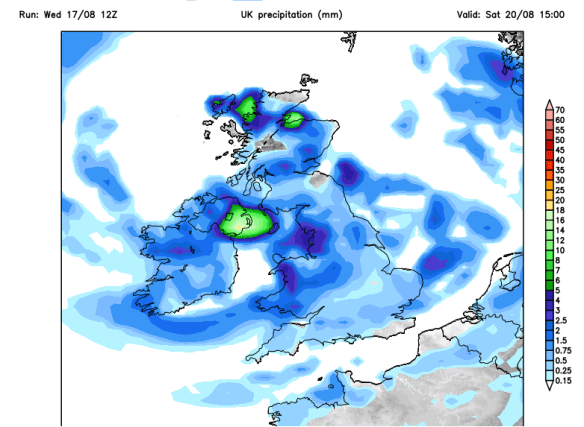
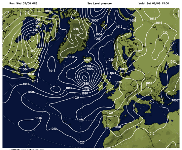
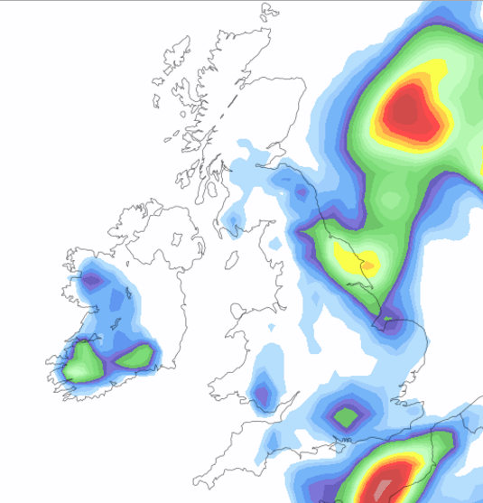
A dreadful Saturday with wind and plenty of showers

Sunday: Windy but the winds should ease later in the day. Another showery affair but these should become more scattered into the evening. Temperatures still below average. Max 17°C

SAT WIND

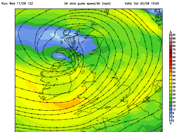
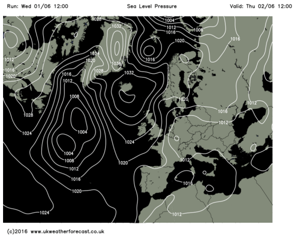
A windy weekend, especially on Saturday. Strongest gusts around the Bristol Channel

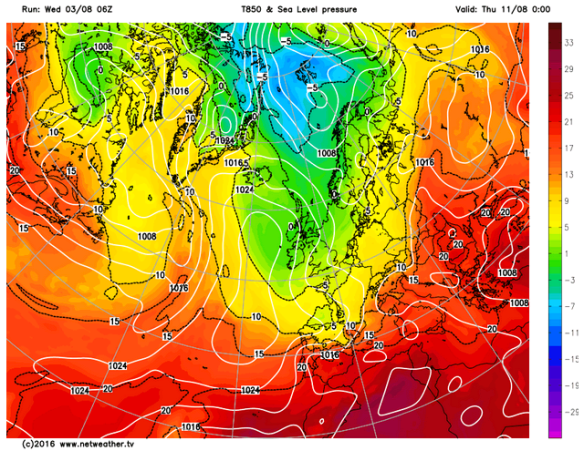
Next week: Starting off a little more settled before showers return. A small chance of it warming up in the south but no heatwave in sight.

Next week warm

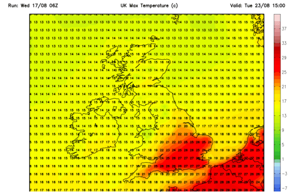
Some heat arrives next week but it doesn’t look to last long and likely to be confined to the south (no change there then)

Follow @ChadWeather on Twitter for all your local weather updates for Manchester and its surrounding areas.

Thanks,
Jon

Forecast issued: 17:30 on Wednesday 17th August 2016

Thursday 4th August 2016 – Sunday 7th August 2016

WOW! It’s August already. Where is this year going? Even one high street retailer has started the Christmas ball rolling this week; just crazy! As for our summer, it’s taking its usual path but what next as the media yet again publish made-up, guesswork nonsense about a ‘MONSTER HEATWAVE to last until September’.

Cool

The clueless media predict heat next week when in fact it will be cool


Thursday: Cooler with a northwesterly wind bringing some hefty showers to the region, some could be thundery. Drier into the afternoon. Temperatures down on recent days. Breezy. Max 18°C.

Friday: The low pressure that’s been around most of the week has slipped into the North Sea, so any showers should start to ease away and become confined to eastern areas. Bright spells developing from the west. Max 19°C.

Sandwiched

Low pressure to the NW and high pressure to the S this weekend


With low pressure arriving to the northwest and high pressure building to the south, we are sandwiched in between this weekend. However, with a southwesterly airflow, temperatures will start to recover.

Saturday: Quite a lot of cloud over the region but some bright spells are likely, which will lift the temperatures and make it feel warm. A risk of some rain from the southwest into the afternoon or evening. Breezy. Max 22°C.

Sunday: It should be less windy as high pressure nudges up from the south. Any early rain should clear to leave a day of bright spells and generally drier. Not as warm as Saturday. Max 20°C.

Cold Northerly

Cooler air into next week


After a settled start to next week, it looks likely to turn cooler and unsettled with temperatures below normal. Later in the week, we could even have a northerly airflow across the UK. There is zero sign of a MONSTER HEATWAVE. Those media clowns start spouting off when the temperatures gets into the mid 20s down south, usually the southeast, and yes this is likely for a few days, but it will not be prolonged, and it will certain not be a monster. They print nothing but made-up stories to sell papers and get you, the public, clicking on their links. Don’t do it.

Follow @ChadWeather on Twitter for all your local weather updates, especially for Manchester and its surroundings areas.

Thanks for reading and feel free to share.

Jon

Thursday 14th July 2016 – Sunday 17th July 2016

Hi all,

An early blog this week so detail subject to change with it being a few days ahead. So, as always keep an eye on my @ChadWeather tweets for updates as this weekend’s weather is still uncertain.

More, yes more, national media reports about a heatwave. Now don’t get me wrong, this weekend was looking much warmer and sunnier but this is now not the case and there is certainly no heatwave in the foreseeable.

After a better few days recently, with showers rather than continuous rain, we see a little ridge of high pressure on Thursday. Therefore it will be a decent day with bright spells after early showers. Temperatures not that warm but feeling pleasant. Max 17°C.

The high pressure was initially expected to hang around but no such luck.  This means breezier on Friday with cloud spilling in from the west which could be thick enough for some light rain and hill-drizzle. Max 18°C.

It gets a little tricky into the weekend as low pressure to the west and high pressure to the south-east do battle.

Some rain is expected early on Saturday and becoming warmer as we drag in air from Spain. It is expected to become brighter into the afternoon and in any sunshine temperatures will respond and it will feel warm and humid. Max 21°C.

A similar day on Sunday. We should keep the rain at bay to the northwest, so bright spells and any breaks will lead to warm, muggy conditions. Again a Max of about 22°C but possibly higher in sunnier spots.

Looking ahead and next week sees us just staying on the settled side with mainly dry and pleasant conditions. This could easily change if the Jet Stream kicks itself back into gear and it will turn wet again. Equally, high pressure could drift back in and in turn bring very warm conditions. Certainly finely-balanced and keeping me on my toes.

June 2016 Stats

Av. Temp 14.7°C
Max Temp 25.2°C (6th)
Min Temp 5.6°C (3rd)
Wettest Day 15.8mm (8th)
Highest Gust 28mph (29th)
Rainfall 89.4mm
Rainy Days 18

Follow @ChadWeather on Twitter to catch all the latest weather updates for Manchester and all its surrounding boroughs.

Thanks,
Jon

Forecast Issued on Tuesday the 12th of July at 15:00

Thursday 16th June 2016 – Sunday 19th June 2016

Hi all,

It seems we’re back to a typical British Summer with cloudy skies and rain. Bar the humidity, last week and the start of June was decent so will the better weather ever return?

Low Pressure

Low pressure has been hanging around all week

All this week low pressure has been sitting on top of the U.K. bringing showers and mainly cloudy conditions. This continues on Thursday. Some of the showers will be heavy but not everyone will catch one. Still feeling a little muggy. Max 18°C.

Showery Theme

A showery set up at the back end of this week

Friday sees little improvement. Further showery rain and not much in the way of sunshine but it should become drier into the evening. Cooler as winds slip northerly. Max 15°C.

Over the weekend things improve slowly as the low pressure slips away.

It will be a better day on Saturday with some bright spells with slightly cooler & fresher air. There still could be a rogue shower or two especially during the first half of the day but better than we’ve been used to. A drier evening. Max 16°C.

A dry day looks on the cards for Sunday. A lot of cloud about which hopefully will break at times for some pleasant sunshine and a little milder than the last two days. Max 18°C.

For next week, it looks like the weather pattern settles down a bit, <just>; so plenty of dry weather with some warm bright spells. We must note we are at a slight risk of some showers from the west at times but I am confident at this stage that it will be a reasonable week. Temperatures could slowly rise if we pick up a warmer southeasterly flow later in the week.

Follow @ChadWeather on Twitter to catch all the latest weather updates for Manchester and its surrounding boroughs.

Photos/Data: www.netweather.tv and http://www.metoffice.gov.uk

Forecast issued at 14:05 on Wednesday the 15th of June 2016.

Thanks for reading.
Jon

Thursday 9th June 2016 – Sunday 12th June 2016

Hi all,

A quick blog this evening after the afternoon was spent storm-watching and seeing a monsoon deliver 15mm of rain; 12.2mm in an hour alone (2nd highest-recorded). It’s not shifted the humid-feel just yet, but that will eventually go as we approach the weekend.

Thursday will dawn misty and mild. Sunny spells during most of the day and feeling muggy. Cloud will thicken and some showery rain is expected later into the evening and overnight. Low risk of thunder and lightning. Still warm. Max 21°C.

A change. If you hate this ‘tropical’ feel to the weather then finally we turn cooler on Friday. Showers will be on and off all day as we enter an mixed spell. Max 17°C.

The weekend is certainly tricky to forecast but it will be unsettled and cooler than what we have become used to.

Cloudy on Saturday with some rain at times. There will be some drier slots with a little brightness but gone are the hot, sunny days of recent weeks. Max 18°C.

Cooler Weekend

A cooler weekend awaits

It looks like Sunday will start dry for most but more rain from the west will arrive. Possibly showery at first then heavier and becoming breezy. Max 17°C.

Wet

Plenty of rain expected between Friday and Sunday

Looking ahead and next week will be cool, possibly temperatures just below average at times, with plenty of showers.

Follow @ChadWeather on Twitter to catch all the latest weather updates for Manchester and all its surrounding boroughs.

Photos/Data: ukweatherforecast.co.uk; www.weatheronline.co.uk
Forecast issued at 20:15 on Wednesday the 8th of June 2016

Thanks,
Jon

Thursday 2nd June 2016 – Sunday 5th June 2016

Hi all,

Finally we’ve had a Bank Holiday Weekend without rain and a reasonable spell of weather. It’s not been too hot and much drier than previous months but will it continue?

High pressure will be sitting to our northwest on Thursday allowing a cool breeze to develop across the region. It will also be cloudy with some light rain around but this will be patchy and not everyone will see some. Sunny spells possible into the afternoon and evening. A little cooler than Wednesday. Max 15°C.

HP to the NW.PNG

High pressure to the NW of the UK on Thursday giving a northeasterly breeze

As well as it being mainly dry and cloudy on Friday some sunny spells will try to develop. Just a chance of an evening shower, but I’m not too worried for my trip to see the T20 Blast between Lancashire and Yorkshire. Max 17°C.

It looks like the weekend will improve as it goes on.

Saturday will be cloudy with a risk of localised drizzle or light rain early on, but skies will brighten and expect some sunny spells. These might trigger a shower or two later but the risk isn’t too high. Max 19°C.

As we enter Sunday more widespread sunny spells are likely as the cloud of recent days breaks up and pleasant conditions develop. A bit warmer too. A risk of some heavy, possibly thundery showers later, especially in the southeast. Max 21°C.

Warm next week

Remaining pleasant into next week with temperatures just in the 20s

All-in-all not a bad forecast and as we go into next week. It looks good with warm conditions and staying dry for most. The warmth could set off some localised showers, especially on the Pennines. Temperatures should sneak into the 20s again before showery rain poses a threat from the southwest later in the week, Thursday or Friday, which could signal a change.

Rain later next week

A change to showery rain from the southwest likely next week (Thursday or Friday)

May 2016 Stats

Av. Temp 11.8°C
Max Temp 24.2°C (8th)
Min Temp 2.2°C (14th)
Wettest Day 14.2mm (21st)
Highest Gust 30mph (9th)
Rainfall 40.6mm (dry)
Rainy Days 15

Follow @ChadWeather on Twitter to catch all the latest weather updates for Manchester and all its surrounding boroughs.

Photos/Data: ukweatherforecast.co.uk
Forecast issued at 17:50 on Wednesday the 1st of June 2016

Thanks,
Jon

Thursday 26th May 2016 – Bank Holiday Monday 30th May 2016

Hi all,

Heatwave on the way? Nope. However, it is looking generally settled from the weekend so not a washout.

After a miserable Wednesday, we hang onto this set-up into the first half of Thursday with plenty of cloud around and some drizzle or light rain. Low-cloud over the hilltops too. It should be a little milder than yesterday and it will generally dry up into the evening. Max 14°C.

Bright spells around on Friday and feeling warm in any sunshine. The warmth might trigger an afternoon shower or two, otherwise dry. Max 17°C.

Another extended 3-day weekend :). Always nice and the weather is going to be reasonably well-behaved.

During Saturday high pressure will be sitting just to our north bringing settled conditions. Sunny spells and temperatures around average. With the sun strong at this time of the year it will feel pleasant enough. Don’t forget that sun-cream. Max 18°C.

Little change into Sunday. Bright or sunny spells and winds should generally be light. The reason we aren’t warming up into the hot category with this settled weather around, is because we have the wind coming from the north-east. Low risk of an isolated shower into the evening. Max 18°C.

storms

Thundery downpours close by on Bank Holiday Monday as they develop towards our E and SE

The high pressure slips away slightly into Bank Holiday Monday but the likelihood is that we stay dry with sunny spells but just increase the shower-risk. Most of the showers will be in the east and south-east of the UK but we can’t rule out a heavy downpour, possibly thundery, later in the day. Max 19°C.

BH Temps

Maximum temperatures for Bank Holiday Monday – no heatwave

At the moment the rest of the week looks settled with high pressure close by. No heatwave yet, but certainly some pleasant conditions and a lot of dry weather. If winds turn to come from the south-east then we could import some warmer air from the Continent.

Follow @ChadWeather on Twitter to catch all the latest weather updates for Manchester and its surrounding boroughs.

Photos/Data: ukweatherforecast.co.uk
Forecast issued at 14:30 on Wednesday the 25th of May 2016

Thanks for reading,
Jon

Thursday 19th May 2016 – Sunday 22nd May 2016

Hi all,

We’ve had a decent May so far, with some warm sunshine, a few calm, chilly nights and mainly dry conditions. In fact we’ve only recorded 13mm of rain this month but this total is set to rise as we enter a few unsettled days.

A chilly and misty or locally foggy start to Thursday, but once this lifts the sun should break through the clouds and a reasonable few hours ahead. Cloud will thicken later though with rain expected late-afternoon and into the evening. Feeling warm and a little muggy. Max 17°C.

A bit of a repeat performance on Friday. Bright spells for the morning and early afternoon so feeling pleasant and not a bad day. Cloud will increase and the wind picks up as showers arrive into the evening. Some of these could be heavy before general rain arrives. So if you’re off out for the Whit Friday celebrations pack something waterproof for late on. Max 16°C.

weather fronts

Plenty of weather fronts from the Atlantic over the coming days keeping us unsettled

It’s a bit of a complex picture as we go into the weekend. A unseasonal low pressure is set to swing in from the southwest Friday night introducing windy conditions for a time and a spell of heavy rain on into Saturday. This will clear quickly to bright spells and showers later. Feeling cool in the fresh wind. Max 16°C.

It’s the Manchester 10k on Sunday and the wife is taking part, so it means I’ll be dodging the showers which will be heavy. Don’t be surprised to see some hail again with thunder and lightning. The bright spells in between the showers will offer some respite. A little cooler. Max 14°C.

Looking ahead into next week and there were some signs of the weather settling down and becoming very warm as high pressure built. This still looks likely, but perhaps delayed until later in the week or towards the end of the month. Otherwise, it will remain showery with temperatures around average.

Follow @ChadWeather on Twitter to catch all the latest weather updates for Manchester and its surrounding boroughs.

Photos/Data: http://www.metoffice.gov.uk
Forecast issued at 14:20 on Wednesday the 18th of May 2016

Thanks for reading,
Jon

Thursday 12th May 2016 – Sunday 15th May 2016

Hi all,

Finally we’ve had our first taste of Spring, well in fact some days felt like summer with a high of 24°C. With UV levels at 6, my tan is coming along nicely. However, cooler weather is on the way.

Thursday will be a decent day after two days of cooler, cloudier conditions. Although slightly breezy, sunny spells are expected and it will be warm. Make the most of it. Max 20°C.

colder air

Colder air arrives Friday and into Saturday


All change as we go into Friday. A bright start then a cold front spreads down from the north introducing a band of cloud and behind it colder air. Generally dry but notably cooler. Max 13°C.

I can promise a settled but chilly weekend which isn’t such bad news. Where we do get some sunshine it won’t feel too bad and despite the cold, the sun is still strong and with a UV of 6. Grab a coat and tan that face :).

frost

A risk of ground frost this weekend


A cold start to Saturday with a chance of some localised frost. The day will be dry with bright spells and cool. Pleasant in any sunshine. Max 12°C.

Very little change into Sunday, sunny spells, chilly early and late. Light northwesterly winds and at least it will be dry. Max 12°C.

Looking ahead to next week and it will be dry to start but then showers are expected as well as a slow rise in the temperatures and back up to the late teens.

Follow @ChadWeather on Twitter to catch all the latest weather updates for Manchester and its surrounding boroughs.

Photos/Data: http://www.ukweatherforecast.co.uk.
Forecast issued at 14:45 on Wednesday the 11th of May 2016

Thanks for reading,
Jon

Thursday 5th May 2016 – Sunday 8th May 2016

Hi all,

From snow a week ago, to some welcome Spring warmth. The beauty of the British weather.

Thursday will be a decent day across the region with warm sunny spells breaking out. Some of the sunshine is likely to turn hazy later on but it will be dry throughout. Feeling very nice and temperatures will respond. Sunshine levels are now showing a UV level of 5 to 6 so sun cream needed if you’re out and about. Max 18°C.

Little change into Friday. Another warm day and with the winds coming from the south-east, the humidity will start to rise slightly. Another dry day with some hazy sunny spells. Max 19°C.

rising temps

Rising temperatures into the weekend as well as the humidity

As we enter the weekend it does become a little tricky to forecast where we might see thunderstorms.

Saturday and Sunday will both be very warm days with some sunny spells. We are now in the humid air from the near Continent and this will increase the risk of some heavy, and possibly thundery showers to break out. Hard to forecast where and when, but something to bear in mind. A good chance we will see a Max of 21°C widely this weekend, maybe even a localised 23°C. Can’t grumble!

storm risk

High humidity and very warm temperatures means a thunderstorm risk on Saturday and even into Sunday

Looking ahead, it will remain very warm into next week with pleasant sunny spells and the odd shower early on. It is set to turn cooler and fresher from midweek though, as winds turn back to a more westerly direction but still pleasant enough.

April 2016 Stats

Av. Temp 6.6°C
Max Temp 16.4°C (20th)
Min Temp -1.3°C (17th)
Wettest Day 13.4mm (9th)
Highest Gust 39mph (6th)
Rainfall 83.8mm
Rainy Days 23

Follow @ChadWeather on Twitter to catch all the latest weather updates for Manchester and its surrounding boroughs.

Photos/Data: http://www.netweather.tv.
Forecast issued at 17:30 on Wednesday the 4th of May 2016

Thanks for reading,
Jon