Thursday 28th August – Sunday 31st August

Hi,

After a disappointing Bank Holiday the weather improved for a couple of days but it’s back to square one these next few days. For Thursday we see early rain then sunshine and afternoon showers. Highs of 19°C.

An area of low pressure is in charge now so Friday will see sunshine and showers with a keen wind. Some showers may merge to give longer spells of rain at times. Highs of 17°C.

It’s a slow, improving picture over the weekend.

Saturday will be a breezy day with bright spells and showers. Some heavy. Winds easing later. Highs of 18°C.

It looks drier as we head into Sunday so apart from the odd shower later on it will be a day of bright spells. Highs of 19°C.

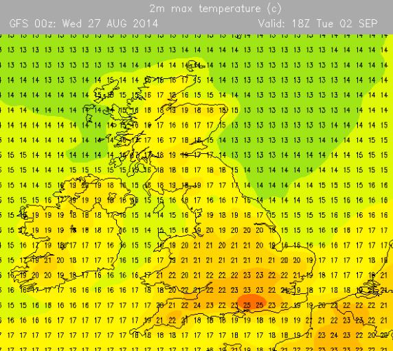
Promising signs next week of plenty of dry weather as high pressure builds. Sunny spells across the region will see temperatures begin to rise so don’t put those BBQs away. Indian Summer?

Follow Jon, @ChadWeather, on Twitter.

Cheers
Jon

IMG_0567.PNG

Thursday 7th August – Sunday 10th August

Issued at 12:10 on Wednesday 6th August

Hi,

Ex-Tropical Storm anyone? 30% chance according to the Met Office (graphic).

After some rain yesterday, Thursday looks much better. Sunny spells across the region with just the chance of an afternoon shower. Pleasant with highs of 21°C.

Friday looks to be a mixed affair. Bright spells throughout the day but also with some showers in the afternoon which could merge to give longer spells of rain in the evening especially to the east. Highs of 19°C.

The weekend doesn’t promise much.

More showers on Saturday, some locally heavy but quite scattered. We are still in August so feeling nice in any periods of sunshine. Highs of 20°C.

It looks like Sunday will start bright but it is expected to turn wet and windy later on as rain spreads from the south-west. This will be heavy in places. This is actually the remnants of Tropical Storm Bertha so one to keep an eye on regarding high rainfall amounts and windy conditions. The track of this “storm” could change, and even miss the UK, so watch for updates on Twitter. Highs of 19°C.

Looking ahead into next week. Not much change but hopefully something more settled in the latter part of the week. No signs of a summer heatwave.

Follow Jon, @ChadWeather, on Twitter.

July 2014 Stats: Warmest 26.2°C (24th); Coldest 9.7°C (10th); Wettest 25.8mm (19th); Windiest 27mph (3rd); Total Rainfall 69mm.

Cheers
Jon

20140806-145941-53981868.jpg

Thursday 10th July – Sunday 13th July

Hi,

It’s an interesting forecast this week as warmer, humid air pushes in from the east which will produce some lively showers as air masses meet.

Thursday will be a sunny day and feeling pleasant especially so during the morning. Cloud spilling in later in the day as rain spreads in from the east in the evening with some heavier bursts, especially over the hills. Highs of 20’C.

As we head into Friday the rain band will move west and introduce much more warmer and humid air. It will feel very pleasant indeed in any sun but we can expect the warmth to trigger off some scattered heavy, thundery showers. A warm night ahead. Highs of 22’C.

Saturday will remain humid and feeling very warm in any sunshine. Expect a day of bright spells and scattered showers which will be heavy and possibly thundery. Highs of 22’C.

At the moment it looks likely that Sunday will be a little fresher, as winds are westerly. The bright spells and scattered showers theme continues, and heavy. Less humid with highs of 20’C.

Next week: Sunny spells and showers. Temperatures around average.

Follow Jon, @ChadWeather, on Twitter.

Cheers
Jon

Thursday 12th June – Sunday 15th June

Hi all,

After a lively unsettled spell which saw some torrential downpours and lightning, we have now settled down into a drier, quieter spell of weather.

Thursday and Friday will be quite similar with settled conditions across the region but not exactly with wall-to-wall sunshine. It looks dry but with variable amounts of cloud at times which should burn off to allow some hazy sunny spells to form. It will feel pleasantly warm in any sunshine with temperatures sitting around 21’C. Friday afternoon could see more in the way of cloud with patchy light rain into the evening and this possibly hanging around into the first part of the weekend as a front passes down the county.

The weekend sees high pressure remain close-by which will keep us settled and mainly dry.

Saturday looks slightly cooler than recent days with some thicker cloud and light rain possible in the morning. I’m hopeful it remains mainly dry though with some pleasant sunny spells later on. Highs of 17’C.

Sunday does look better with more in the way of sunny spells developing and remaining dry. A little warmer with highs of 20’C. An outside chance of an easterly breeze picking up.

So not a bad forecast but any cloud encroachment from the north late Friday and Saturday could spoil things a little.

If you are out and about for any length of time in any sunshine, then remember sunscreen. The sun is high in the sky in June and burn-times are at their highest.

Looking ahead it looks settled initially and warm with details uncertain towards the end of next week. Will high pressure hang on?

Follow Jon, @ChadWeather on Twitter.

Cheers
Jon

20140611-095406-35646679.jpg

20140611-095407-35647479.jpg

Thursday 5th June – Sunday 8th June

As of: 14:00 Wednesday 4th June

Hi,

So May has been and gone and did offer us a few nice warm days, but overall it was very wet with above average rainfall. So now we are in the Meteorological summer what can we expect? Showery and quite warm probably sums it up best.

Thursday morning sees some rain and cloud left over from Wednesday which will eventually ease and break. We might see some brighter spells later on and warmer than Wednesday. Highs of 16’C.

During Friday we should see some warm, bright spells but also turning humid as winds turn southerly. This humidity might produce an evening shower. Highs of 20’C.

The weekend looks a showery affair and initially humid.

Saturday continues with the showery theme. Scattered heavy showers, with possible hail or thunder but also with some bright spells. Some torrential rain is possible. Highs of 19’C and feeling muggy.

Sunday more of the same, showers, some heavy across the region but these should ease away. Again, some bright spells and feeling humid at first, with highs at 19’C, although it should start to feel fresher.

Looking ahead the showery spell continues but if winds turn to a more southerly direction again then possibly we could see something warmer later. We’ll see.

To keep up-to-date with your local weather, follow Jon, @ChadWeather on Twitter.

May 2014 Stats: Av. Max Temp: 15.0’C; Warmest: 23.4’C (19th); Coldest: 1.5’C (3rd); Wettest: 18.2mm (10th); Windiest: 33mph (9th); Total Rainfall: 119.2mm (above average).

Cheers
Jon