Thursday 17th December 2015 – Sunday 20th December 2015

Hi all,

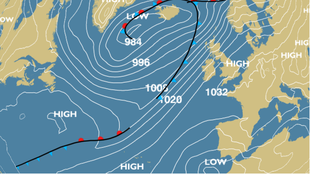
You’d be forgiven for thinking it was spring outside today as temperatures are very much on the mild side with 14°C in some spots. The mild theme looks set to continue before we do cool slightly towards Christmas. Cool yes, but not enough for a White Christmas.

Looking at the latest Christmas Day forecast all I’m seeing is mild with temperatures above average, max 11°C, rain possible, all blown in on a moist south to southwesterly wind. Grim reading for cold-lovers wishing for a snowy 25th of December. So the next 4 days…..

XmasDayTemp

Thursday will be generally cloudy with some rain spreading across the region during the day on a steady breeze. Slightly drier later on and another very mild day. Max 12°C.

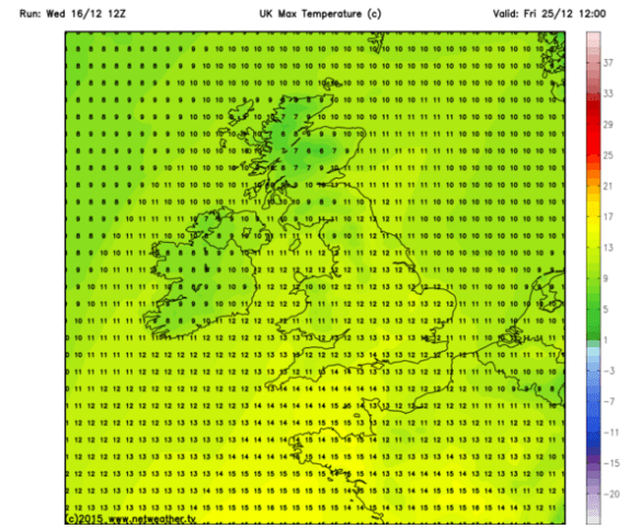
We will have more weather fronts coming in from the west and southwest during Friday and Saturday. Both days will have plenty of cloud, mild with rain at times but unlikely to be as persitent or as heavy as we had last Saturday which caused localised flooding and the postponement of Oldham Athletic’s home game. Friday sees our best chance of some brightness until rain arrives. Saturday will be the mildest day, or should I say warmest, and temperatures [night-time] could be December record-breaking across some parts of the UK. Friday; Max 12°C but we could see 15°C in some favoured spots on Saturday.

Sunday sees early rain clearing to showers and even some bright spells later on. Turning fresher and cooler once the rain clears away. Max 11°C.

Next week sees the overall mild, wet, unsettled theme continue. No sign of significant cold or snow.

For all your weather updates local to Oldham, Rochdale, Tameside, Manchester and Lancashire follow @ChadWeather on Twitter.

See you next week for a Christmas and New Year update.

Thanks for reading,

Jon


Thursday 10th December 2015 – Sunday 13th December 2015

Hi all,

I’m crying out for some colder weather and even some snow. In fact just cold, frosty, foggy mornings would do but nothing on the horizon. My guess would be, don’t get your hopes up on proper cold until we get to mid-January. 

After early rain and some showers on Thursday we’re left with a day of bright spells. Feeling fresh and a chance of some showers later on. Max 9°C.

Mainly cloudy during Friday afternoon with a chance of showers. Some bright spells are possible during the morning, especially to the east. Cooler. Max 8°C.

It’s a little complicated during the weekend. 

After a cloudy morning rain spreads up from the southwest on Saturday and with us under slightly colder air there is a chance we could see some sleet or snow on the higher ground and the Pennines. It shouldn’t last too long as slightly milder air arrives slowly within the rain. Max 6°C.

It’s favouring staying cloudy with further rain on Sunday and cool. It shouldn’t be as windy as recently on both days, good news but unfortunately we are struggling for dry weather these days. Max 8°C.

Next week sees little in the way of change. Some rain or showers at times with drier slots in between. No sign of significant cold.

November 2015 Stats: Warmest 16.1°C; Coldest -1.7°C; Wettest 29mm; Windiest 53mph; Total Rainfall 231.8mm (record).

Follow @ChadWeather on Twitter for local weather updates.

Thanks

Jon

Thursday 3rd December 2015 – Sunday 6th December

Hi all,

Wet wet wet. The only way to describe the last week and the month of November which turned out to be the wettest month I’ve ever recorded with 231.8mm of rain falling. The previous record was 185.4mm in December 2012.

We are now in the meteorological winter and we start December mild with more rain on the way. 

Thursday will see rain across the region. Some heavy bursts, especially on the hills with a risk of localised flooding once again. It will clear later in the evening. Mild and breezy with cooler air following on overnight. Max 11°C.

Friday promises to be the best day we’ve had for a while. We are in between weather systems so bright spells and it should remain dry albeit windy. Cooler and winds increasing overnight with gale-force gusts. Max 9°C.

It all gets a bit complicated into the weekend. 

A band of heavy rain will move in on Saturday associated with some gusty winds. It will move from NW to SE and remain very windy throughout with 60mph gusts possible. A warning is already in place. Milder for a time. Max 10°C.

Still very windy early on Sunday but easing quickly. Still quite cloudy with some rain or showers at times. Possibly brighter & drier later. Mild temperatures for December. Max 12°C.

Next week looks cooler with temperatures dropping to more typical December values.

For updates on this weekend’s possible stormy weather follow @ChadWeather on Twitter. 

Thanks for reading. 

Jon

Thursday 26th November 2015 – Sunday 29th November 2015

Hi all,

It’s still not quite winter but you wouldn’t have thought after some frost and snow during last weekend’s cold snap. So, as we approach December what can we expect?

Thursday will start fine with bright spells but some low cloud and drizzle possible in places especially towards the hills. Cloud increasing into the afternoon with some light and patchy rain expected later on. Max 9°C.

A very similar pattern on Friday. Not a bad morning but winds increasing and this time heavier rain and gusty winds arriving into the afternoon and evening. Milder for a time then colder overnight. Max 11°C.

It’s certainly déjà vu on Saturday as again the morning isn’t too bad but soon heavy rain (possible wet hill-snow for a time) and windy conditions spread across the region to give a disappointing day. Notably colder especially so with the wind. Max 7°C.

Sunday will remain cloudy with light rain likely at times but hopefully a bit drier later in the day with the odd bright spell. Milder again. Max 9°C.

Looking ahead and it’s likely to stay unsettled and mild as we go into December and the meteorological winter. No sign of anything particularly colder.

Follow @ChadWeather on Twitter for all your local weather updates. 

Thanks for reading.

Jon

Thursday 19th November 2015 – Sunday 22nd November 2015

Hi all,

It’s been a mild and very windy week with further rain and already two named-storms have crossed the UK. So what next? A blast from the north, that’s what. Snow? Maybe a little for some of us. 

Thursday will be a day of bright spells and the odd scattered shower. A much better day than recently. Still breezy and temperatures around average. Max 10°C.

A breezy day again on Friday and it will start to feel colder, especially later on. Some showery rain pushing south which could be a bit sleety over the hills. Max 8°C.

All change into the weekend as the air is dragged in from the Arctic. 

Colder still as we go into Saturday but with some sunny spells. There is a chance of some wintry showers of hail or snow later on and this could give a slight covering especially to the east and more likely on the higher ground. A cold day throughout with a biting subzero windchill. Clearing skies later overnight leads to a frostMax 4°C. 

Apart from a risk of a wintry shower on Sunday, the day looks generally dry with sunny spells after a frosty and maybe misty start. Cold again but less of a biting breeze than Saturday. Cloud amounts might increase later on. Max 5°C.

Looking into next week and it will become milder again with temperatures returning to 8-10°C with some showery rain at times. No sign of this weekend’s cold snap returning. 

To keep up to date with weather local to Oldham, Manchester and the surrounding areas follow @ChadWeather on Twitter. 

Thanks for reading. 

Jon

Thursday 12th November 2015 – Sunday 15th November 2015

Hi all,

It’s been a lively few days as our Autumn settled spell came to an end. We had over an inch of rainfall on Monday and then windy conditions followed. The far northwest of the UK is set to be hit by Abigail, the first named UK Storm [by the Met Office], as we approach the weekend but what impact will it have on us? Also, after the record-breaking warmest night ever in November on Monday night, is there any sign of colder weather?

A drier and quieter spell of weather on Thursday, albeit brief. Sunny spells and dry for daylight hours. Winds increasing later on as well as cloud amounts. A little fresher than recently. Rain into the evening with gusty winds. Max 13°C.

A colder day on Friday, a shock to the system after the recent mildness, with some squally showers. Hail is possible, maybe a crack of thunder and just maybe a bit of sleet over the highest hills. Feeling cold in a strong wind with local gales as Abigail brushes the top-left-hand corner of the UK. Cold-wise, it’s only a one-day cold spell. Max 9°C.

Saturday will have bright spells and showers to start the day but soon more rain pushes in from the west as ex-Hurricane Kate arrives. Gradually milder again, but as Friday, a very windy day. Max 12°C.

Saturday’s rain clears away Sunday morning with some brightness to follow but short-lived as rain is likely to come in from the south-west later in the day. Some uncertainty over Sunday’s weather with the unsettled theme so keep an eye out on Twitter. Max 14°C.

Looking ahead and next week remains unsettled. Temperatures cooler and more typical for November with bright spells in between spells of rain and wind. No sign of any snow or significant cold.

October 2015 Stats: Warmest 18.9°C; Coldest 3.4°C; Wettest 10mm; Windiest 30mph; Total Rainfall 45.4mm.

To keep up to date with your local weather and for any updates, follow @ChadWeather on Twitter.

Thanks for reading.

Jon

Thursday 5th November 2015 – Sunday 8th November 2015

Hi all,

November? Already? WOW! Where has 2015 gone? One thing for certain, it doesn’t feel like November out there. It’s been very mild but is that trend set to continue?

Thursday will start cloudy and mild with some hill-fog. Mainly dry for most of the morning apart from localised showers then rain, heavy at times spreads up from the southwest as we approach midday. A very wet and breezy afternoon. For the evening bonfires the rain looks set to clear around 7pm but with some drizzle to follow. Mild. Max 15°C.

Another band of rain whizzes across the region on Friday with showers following on behind. Again very mild and windy at times. The evening is looking a little bit drier so a better night for a bonfire and fireworks. Max 15°C.

The weekend will start lively with no let up in the weather steaming in from the Atlantic.

Saturday gives another repeat performance. Heavy rain and windy weather spreads in from the southwest followed by blustery showers. There is some uncertainty about the timing and exact position of the strongest winds but it’s very possible that we could see gusts to 40-50mph so stay tuned to Twitter for updates. Hopefully the winds ease slightly into the evening. Another mild one but feeling cooler because of the wind. Max 15°C.

A better morning is expected on Sunday with lighter winds and a mainly dry picture. However it looks all change again into the afternoon with strong winds and rain racing in. A little cooler with bright spells. Max 13°C.

Looking ahead and next week remains unsettled with further spells of wind, possible gales especially on Monday, and further rain. The mild weather holds on before slowly becoming cooler.

For the very latest on your local weather follow @ChadWeather on Twitter.

Thanks for reading.

Jon

Thursday 29th October 2015 – Sunday 1st November 2015

Hi all,

Guess what? We had some brief snow on one of the highest mountains in Scotland but what about the rest of us. Nothing of course. In fact some areas in Scotland and SE England saw 20°C this week. Not bad going that for late October.

Off Trick-or-treating or to a bonfire this weekend, then it’s not looking too bad.

Thursday will start wet with a band of heavy rain moving from west to east. The afternoon will be much better with sunny spells and drier conditions. Max 13°C.

We drag up very mild air again on Friday and after a few morning showers the afternoon should be drier but staying generally cloudy. Temperature above average. Max 16°C.

Similar to the last two days sees Saturday start cloudy with a little rain or drizzle about. This soon clears to a day of bright or sunny spells. Light winds as a ridge of high pressure builds from the south. Max 14°C.

Sunday is likely to start misty or foggy and a little chilly. Not a bad day in store with bright spells at times. Light winds and a little cooler. Max 13°C.

Next week doesn’t see much change with mostly dry weather around, some milder spells with light winds. Certainly no sign of an early winter chill.

Thanks for reading.

Jon

High pressure builds in later this weekend settling the weather down once more.

High pressure builds in later this weekend settling the weather down once more. Photo: BBC Weather.

Thursday 22nd October 2015 – Sunday 25th October 2015

Hi all,

Well would you believe it. The newspapers, sorry trash-mags, are at it again. “It’s going to snow next week”; “It’s going to be the coldest, snowiest winter for 50 years” and of course what we all want “A White Christmas”. What a load of nonsense, putting it politely. It’s nothing but guesswork and in a word ‘lies’ in order to sell papers and get everyone talking. In truth, no-one knows what this coming Winter will be like and yes I personally would love a White Christmas and several feet of snow; but all I can do is hope. There are no facts and proof that all the media stories hold any truth.

So, no snow on the horizon just yet 🙂 but what can we expect the coming 4 days and into next week.

A cloudy start to Thursday with some local drizzle or light rain around. Generally a drier picture after that with sunny spells. Feeling cooler than Wednesday with the odd afternoon shower possible. Breezy. Max 13°C.

Friday will be quite similar. A little ridge of high pressure settles things down, so bright spells and mainly dry. Just a very low risk of an isolated shower. Light winds. Max 13°C.

The weekend will not start well as a band of rain spreads in from the north-west on Saturday with some heavy bursts and gusty winds. This will sink south and leave some drizzle behind it for a few hours. Eventually drying up into the late-afternoon or evening. Gusty south-westerly winds for a time then switching back north-westerly and easing slightly. Not much difference in temperatures to previous days but it will turn cooler later on. Max 13°C.

A colder feel to Sunday with bright spells and some scattered showers. A chilly breeze across the region but looking a better day than Saturday. Temperatures down a notch. Max 11°C.

Looking ahead into next week the Atlantic is pretty much back in charge bringing spells of wet and windy weather but with sunny spells and drier interludes either side of low pressure systems.

To keep up to date with your local weather, follow @ChadWeather on Twitter.

Thanks for reading.
Jon

Thursday 15th October 2015 – Sunday 18th October 2015

Hi all,

High pressure remains in charge of our weather and is established away to our east introducing cold winds. Of course no snow, crazy media talk as usual, but some parts of Eastern Europe have seen an early snowfall. Looking ahead little change. 

A cold and possibly foggy start to Thursday with a touch of ground frost. A day of sunny spells to follow with a chance of a shower in the east. Cold breeze. Max 13°C.

Friday is likely to see more in the way of cloud and a shower or two can’t be ruled out. Again some bright spells and a cold east to northeast breeze. Max 13°C.

I wish I could promise something more interesting over the weekend but I can’t. 

Saturday and Sunday similar days. Sunny spells at times but also a lot of cloud coming in on a chilly northeasterly wind. Any cloud breaks overnight will lead to mist and fog patches and a local ground frost. Max 11-13°C.

No immediate change on the horizon (boring) but it won’t be long before the high pressure slips away and we see a more unsettled theme return. 

Follow @ChadWeather on Twitter for all your local weather updates. 

Thanks for reading. 

Jon