Thursday 14th August – Sunday 17th August

Hi all,

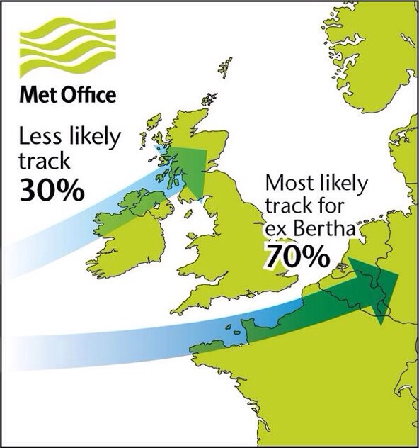
After the remnants of ex-Hurricane Bertha we can expect a couple of calmer days ahead but with rain still in the forecast.

With the aforementioned storm still sitting away to our north-east we can expect a cool day on Thursday with a brisk north-westerly wind feeding in showers across the region. Brighter and drier later. Highs of 17°C.

Friday we fair a little better with a drier day expected and less windy. Sunny spells and one or two showers well-scattered. Highs of 18°C.

The weekend sees Saturday looking the better day of the two.

Bright spells during Saturday and most places dry during daylight hours. More cloud into the late-afternoon and with rain expected late evening and overnight. Highs of 18°C.

Sunday early rain clears to sunshine and showers. Some heavy and frequent in places. A little breezy again. Cooler with highs of 16°C.

Looking ahead still no sign of a heatwave or any very warm weather returning as it remains cool for August with frequent showers.

Follow Jon, @ChadWeather, on Twitter.

Cheers
Jon

Thursday 7th August – Sunday 10th August

Issued at 12:10 on Wednesday 6th August

Hi,

Ex-Tropical Storm anyone? 30% chance according to the Met Office (graphic).

After some rain yesterday, Thursday looks much better. Sunny spells across the region with just the chance of an afternoon shower. Pleasant with highs of 21°C.

Friday looks to be a mixed affair. Bright spells throughout the day but also with some showers in the afternoon which could merge to give longer spells of rain in the evening especially to the east. Highs of 19°C.

The weekend doesn’t promise much.

More showers on Saturday, some locally heavy but quite scattered. We are still in August so feeling nice in any periods of sunshine. Highs of 20°C.

It looks like Sunday will start bright but it is expected to turn wet and windy later on as rain spreads from the south-west. This will be heavy in places. This is actually the remnants of Tropical Storm Bertha so one to keep an eye on regarding high rainfall amounts and windy conditions. The track of this “storm” could change, and even miss the UK, so watch for updates on Twitter. Highs of 19°C.

Looking ahead into next week. Not much change but hopefully something more settled in the latter part of the week. No signs of a summer heatwave.

Follow Jon, @ChadWeather, on Twitter.

July 2014 Stats: Warmest 26.2°C (24th); Coldest 9.7°C (10th); Wettest 25.8mm (19th); Windiest 27mph (3rd); Total Rainfall 69mm.

Cheers
Jon

20140806-145941-53981868.jpg

Thursday 31st July – Sunday 3rd August

Hi,

July has been a decent month but as we enter August the weather is set to turn unsettled with periods of showery rain.

Thursday will see some bright spells but also with a north-westerly breeze. This will introduce some scattered showers especially later in the day. Highs of 20°C.

Friday will see low pressure taking charge so expect frequent spells of showery rain with bright spells in between. Thunder a possibility. Cooler and breezy at times. Highs of 19°C.

Not much improvement over the weekend.

Saturday sees showers at times continuing and some prolonged periods of rain are possible, again don’t rule out some thunder. Feeling cool and breezy. Either side of the showers some bright spells are possible. Highs of 18°C.

Unsettled conditions stay in place for Sunday with little change. Bright spells either side of showers which might ease slightly later. Breezy. Highs of 19°C.

Looking ahead it continues unsettled with average temperatures with breezy and wet conditions at times.

Follow Jon, @ChadWeather, on Twitter.

Cheers
Jon

Thursday 24th July – Sunday 27th July

Issued: Wednesday 23rd July at 11:30am

Hi,

Hope you’re all enjoying this weather.

July continues to be a decent month of summery weather with little complaints even after a stormy awakening on Saturday morning.

Thursday sees the lovely hot weather continue. It will remain dry with plenty of sunshine. Highs of 26°C but humid. Possibly misty overnight.

After a warm night’s sleep, Friday remains muggy with very warm sunny spells after any low cloud clears. There is an outside chance of a hefty late-afternoon shower. Highs of 26°C.

With it being July don’t forget sunscreen. In weather like this you will burn easily as UV levels are close to their UK high of 7.

Saturday will see more cloud especially later on. After any early cloud lifts it will be very warm with bright spells. We can’t rule out the risk of a heavy shower later in the day, as clouds build, but most places dry. Cooler evening. Highs of 24°C.

It looks like Sunday will be cooler with some sunny spells but with showers likely in the afternoon and evening. Highs down at 21°C.

Looking ahead it seems next week will be a little cooler but still quite settled with bright spells.

Follow Jon, @ChadWeather on Twitter.

Cheers
Jon

Thursday 10th July – Sunday 13th July

Hi,

It’s an interesting forecast this week as warmer, humid air pushes in from the east which will produce some lively showers as air masses meet.

Thursday will be a sunny day and feeling pleasant especially so during the morning. Cloud spilling in later in the day as rain spreads in from the east in the evening with some heavier bursts, especially over the hills. Highs of 20’C.

As we head into Friday the rain band will move west and introduce much more warmer and humid air. It will feel very pleasant indeed in any sun but we can expect the warmth to trigger off some scattered heavy, thundery showers. A warm night ahead. Highs of 22’C.

Saturday will remain humid and feeling very warm in any sunshine. Expect a day of bright spells and scattered showers which will be heavy and possibly thundery. Highs of 22’C.

At the moment it looks likely that Sunday will be a little fresher, as winds are westerly. The bright spells and scattered showers theme continues, and heavy. Less humid with highs of 20’C.

Next week: Sunny spells and showers. Temperatures around average.

Follow Jon, @ChadWeather, on Twitter.

Cheers
Jon

Thursday 3rd July – Sunday 6th July

Hi,

After a mixed bag last weekend and then a sunnier and warmer start to this week, the weather is again set to turn unsettled again after June 2014 was the driest month for 9 months.

After a very warm and lovely Wednesday, Thursday sees a change. A cloudy day with some patchy rain but not everywhere seeing some and it should be drier by evening. The breeze will also pick up. Highs of 19’C.

Into Friday it remains cloudy with rain slowly spreading across the region in the afternoon on a freshening noticeable wind. The rain is likely to become more persistent as the day progresses. Muggy with highs of 19’C.

Saturday sees any early rain clearing to a day of bright spells. Further showers can’t be ruled out as low pressure anchors close by. Feeling fresher. Still a cool breeze but easing slowly. Highs of 17’C.

On Sunday we can expect sunshine and some isolated heavy showers. These showers hopefully easing towards evening. Average temperatures with highs of 17’C.

Looking ahead sees a similar set-up with warm bright spells in between showers.

June 2014 Stats: Warmest: 23.1’C (18th); Coldest: 5.7’C (6th); Wettest: 12.8mm (7th); Windiest: 29mph (10th); Total Rainfall: 49.2mm.

Follow Jon, @ChadWeather on Twitter.

Cheers
Jon

Thursday 26th June – Sunday 29th June

Hi,

Although we didn’t experience a heat wave recently, we have certainly enjoyed a long spell of warm weather with reasonable amounts of sunshine. The weather is now set to become more unsettled with occasional rain returning.

Thursday looks a generally cloudy day with some sunny spells. Cloud coming and going. It should remain dry. Highs of 18’C.

Heading into Friday low pressure takes charge and a showery day is expected with some of the showers heavy and slow-moving later. It will feel cooler with an easterly wind. Highs of 16’C.

The weekend looks a lot different to recent ones with some showers and a cooler feel to the weather.

On Saturday we can expect bright spells but also showers on and off, some heavy with possible thunder. Highs of 16’C.

We end the weekend with Sunday showing little change. Bright spells and some showers. Highs around average at 17’C.

We are still in June and in any sunshine we do see, it will feel pleasant at times.

Looking ahead the showery, more unsettled theme continues.

Follow Jon, @ChadWeather, on Twitter.

Cheers
Jon

Thursday 19th June – Sunday 22nd June

Hi all,

High pressure has been around for a week now and although it normally brings a lot of sunshine and dry weather it can also trap in a lot of cloud; a “cloudy high”, and this has been the case this time around.

During Thursday we can expect a lot of cloud once more with a cool northerly breeze. This cloud might be thick enough for some occasional light rain but unlucky to catch some. Highs of 19’C.

Mainly cloudy on Friday morning and light drizzle can’t be ruled out on higher ground but isolated. Brighter spells into the afternoon. Highs of 18’C.

Onto the weekend and high pressure stays close so a lot of dry weather with variable amounts of cloud.

Saturday looks like being a mainly dry day with bright spells and again a lot of cloud stuck under the high pressure so the sun coming and going. Highs of 19’C.

For Sunday I can’t promise much of a change. Cloudy with bright spells at times and dry. Highs of 19’C.

Looking ahead it does look settled and dry with variable cloud.

For updates, follow Jon, @ChadWeather on Twitter.

Cheers
Jon

Thursday 12th June – Sunday 15th June

Hi all,

After a lively unsettled spell which saw some torrential downpours and lightning, we have now settled down into a drier, quieter spell of weather.

Thursday and Friday will be quite similar with settled conditions across the region but not exactly with wall-to-wall sunshine. It looks dry but with variable amounts of cloud at times which should burn off to allow some hazy sunny spells to form. It will feel pleasantly warm in any sunshine with temperatures sitting around 21’C. Friday afternoon could see more in the way of cloud with patchy light rain into the evening and this possibly hanging around into the first part of the weekend as a front passes down the county.

The weekend sees high pressure remain close-by which will keep us settled and mainly dry.

Saturday looks slightly cooler than recent days with some thicker cloud and light rain possible in the morning. I’m hopeful it remains mainly dry though with some pleasant sunny spells later on. Highs of 17’C.

Sunday does look better with more in the way of sunny spells developing and remaining dry. A little warmer with highs of 20’C. An outside chance of an easterly breeze picking up.

So not a bad forecast but any cloud encroachment from the north late Friday and Saturday could spoil things a little.

If you are out and about for any length of time in any sunshine, then remember sunscreen. The sun is high in the sky in June and burn-times are at their highest.

Looking ahead it looks settled initially and warm with details uncertain towards the end of next week. Will high pressure hang on?

Follow Jon, @ChadWeather on Twitter.

Cheers
Jon

20140611-095406-35646679.jpg

20140611-095407-35647479.jpg

Thursday 5th June – Sunday 8th June

As of: 14:00 Wednesday 4th June

Hi,

So May has been and gone and did offer us a few nice warm days, but overall it was very wet with above average rainfall. So now we are in the Meteorological summer what can we expect? Showery and quite warm probably sums it up best.

Thursday morning sees some rain and cloud left over from Wednesday which will eventually ease and break. We might see some brighter spells later on and warmer than Wednesday. Highs of 16’C.

During Friday we should see some warm, bright spells but also turning humid as winds turn southerly. This humidity might produce an evening shower. Highs of 20’C.

The weekend looks a showery affair and initially humid.

Saturday continues with the showery theme. Scattered heavy showers, with possible hail or thunder but also with some bright spells. Some torrential rain is possible. Highs of 19’C and feeling muggy.

Sunday more of the same, showers, some heavy across the region but these should ease away. Again, some bright spells and feeling humid at first, with highs at 19’C, although it should start to feel fresher.

Looking ahead the showery spell continues but if winds turn to a more southerly direction again then possibly we could see something warmer later. We’ll see.

To keep up-to-date with your local weather, follow Jon, @ChadWeather on Twitter.

May 2014 Stats: Av. Max Temp: 15.0’C; Warmest: 23.4’C (19th); Coldest: 1.5’C (3rd); Wettest: 18.2mm (10th); Windiest: 33mph (9th); Total Rainfall: 119.2mm (above average).

Cheers
Jon