A breather from the relentless rain and more seasonal temperatures – Thursday 22nd February 2024 – Sunday 25th February 2024

Hi all,

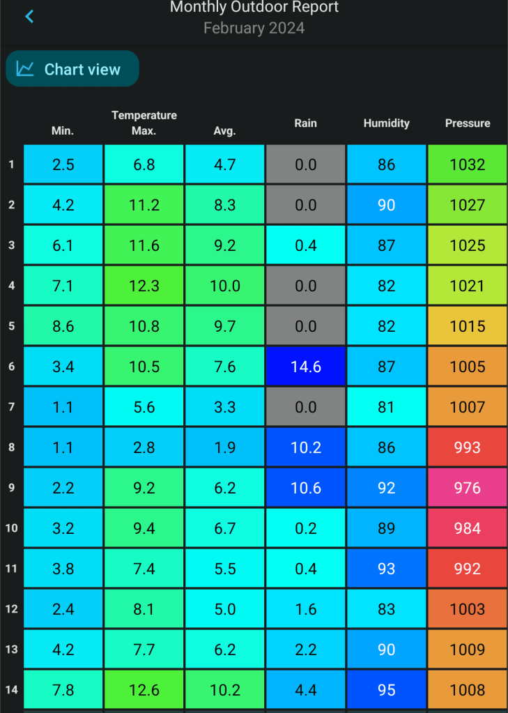
It’s been another wet week (now rained for 14 days consecutively) and the same can be said about February, which on average, is the 6th driest month of the year. It now has well-above the average rainfall. 158% to be precise. It’s been another poor month with a lack of sunshine and certainly not wintry apart from one snowfall event which was mostly confined to higher ground.

We’ve had 5 days in February with over 10mm recorded.

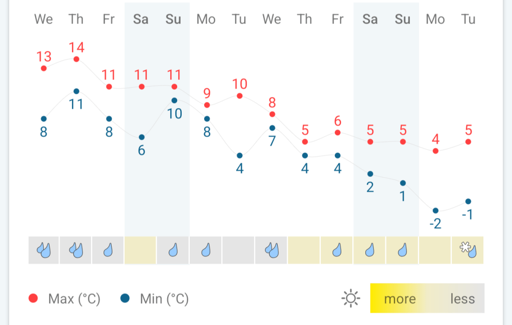
Thursday: A cold-front will come through before dawn bringing a squall-line of heavy rain and gusty winds. Also, it will bring a colder airmass. The rest of the day will have bright spells and some blustery showers will could be thundery and wintry on the tops. Feeling much colder than recently, especially in the breeze. Patchy ground-frost overnight. Max 8°C Min 2°C

Colder air arrives from the NW during Thursday morning

Friday: Cloudy for the morning with some scattered showers. More in the way of bright spells as the day progresses, still with the odd shower. Drying up later with the skies clearing, leading to an overnight frost and ice. Max 9°C Min -1°C

Weekend: Drier than recently.

Saturday: A frosty start, and it looks like a promising day with sunny spells and drier than recently. I can’t rule out an isolated shower drifting in from the Irish Sea though. Lighter winds. Max 9°C Min 1°C

Sunday: There is a chance that a low pressure drifting across southern England reaches us. But, for now that’s not the most likely outcome. However, it will bring some high-cloud, so expect some hazy bright spells after a cold start. Hopefully a dry day but feeling cool with more in the way of a breeze compared to yesterday. Max 8°C Min 4°C

Hopefully it remains a close call with an area of low pressure on Sunday.

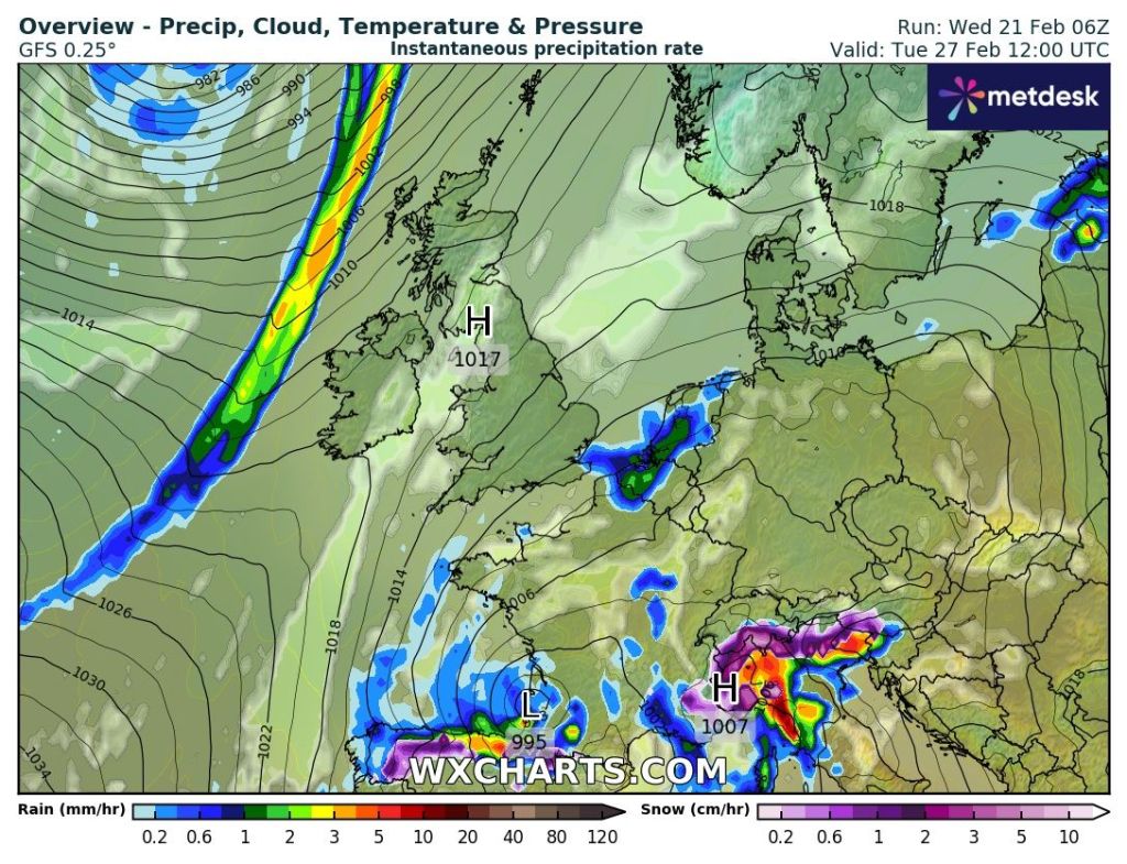
Outlook: A ridge of high pressure building in from the southwest means a couple of settled days to start the working week. Bright spells, a bit windy at times and dry. Temperatures around average but it seems we will have too much of a breeze and cloud-cover to lead to any frosts. After that, it looks set to turn unsettled once more.

Brief ridge of high pressure early next week. At last some drier weather.

Follow @ChadWeather on X for the latest forecasts and warnings.

Thanks,

Jon

Images: http://www.wxcharts.com

Forecast Issued: Wednesday the 21st of February 2024 at 6pm.

Staying mild and wet at times. Cold start to Spring? – Thursday 15th February 2024 – Sunday 18th February 2024

Hi all,

Two weeks left of meteorological winter and the remainder of it looks generally mild to very mild, but there are hints that it turns colder towards the end of the season and into the beginning of Spring.

February 2024 so far…..(14th data up to 2:55pm)

Thursday: It’ll be a very mild day with moist southerly winds. The day will start cloudy with bits and pieces of rain here and there and some more organised rain around lunchtime. A drier slot then more rain into the evening. This weather-front is a cold front so overnight it will become a little bit cooler. Max 15°C Min 9°C

NW England will be one of the wettest places over the next 5 days (Wed-Sun) with an inch or so expected.

Friday: A cloudy start with a few showers, but it should improve a little bit into the afternoon with some bright spells, but I can’t rule out it remaining dry everywhere. Quite a brisk westerly wind and cooler than yesterday. Max 11°C Min 7°C

Weekend: More rain but hopefully most will come overnight.

The UK and most of Europe will have temperatures well above average over the coming days.

Saturday: Generally cloudy with a few bright spells. The cloud will thicken further as the day progresses and rain is expected late in the day and overnight. Again, it will be very mild for the time of year and breezy. Max 13°C Min 9°C

Sunday: Sunday could well start with a bit of rain which will move away quite swiftly and then it should be a drier day with the odd bright spell and again another mild one. The cloud will thicken further as the day progresses and rain is expected late in the day. Temperatures down just a notch as winds swing more west-to-northwest later. Max 12°C Min 7°C

Outlook: We start the working week with mostly cloudy skies and a few batches of showers. A brief ridge of high pressure should allow for a day or a couple of days of drier weather midweek but then it looks to turn a little bit cooler and possibly even colder towards the end of the month with a risk of wintry showers. The colder end to February and start of March is not certain so look out for updates on X. I’m sure winter’s not done with us yet. 

Colder end to February?

Follow at @Chadweather on X for the latest forecasts and warnings.

Thanks,

Jon

Forecast Issued: Wednesday the 14th of February 2024 at 4:40pm. 

Images: http://www.wxcharts.com, my Weather Station Data and the Weather&Radar app.

Disruptive snow in places, quickly followed by a thaw – Thursday 8th February 2024 – Sunday 11th February 2024

Hi all,

Snow is on the way which could be disruptive in places on Thursday, especially so on trans-Pennine routes and areas >300M.

There are two warnings in place. Yellow and Amber.

Yellow from THU 6am to FRI 6am.

Amber from THU Noon to THU 6pm.

Snow is still possible to low-levels with 1-3cm not out of the question. The current Met Office warning has up to 25cm on those higher routes so stay tuned to the forecast.

GFS model’s prediction on Snow Depth by Thursday evening.
ECMWF HRES model’s prediction on Snow Depth by Thursday evening.
ARPEGE model’s prediction on Snow Depth by Thursday evening.
AROME model’s prediction on Snow Depth by Thursday evening.
UKV model’s prediction on Snow Depth by Thursday evening.

From the charts above I’m swinging towards chart 3, 4 or 5. I think snow-lovers west of Manchester will be disappointed. I do expect to see some big flakes of snow which are always nice to see even if they don’t stick. So look out for Prawn Cracker snowflakes.

Thursday: Cloudy with rain, sleet and snow pushing up from the south. It is expected to start around 7am. Not too windy for the first half of the day but later on and overnight 50mph gusts are possible with a bitter, sub-zero windchill.

Most areas will see a spell of snow for several hours leading to accumulations even at low-levels but with the intensity varying west of Manchester, here is likely to see rain, sleet and snow, so I can’t guarantee a snow-cover everywhere.

As the day wears on into the afternoon, the snow will continue above 250M, but on lower-lying areas it is expected to become a bit more patchy and we’re likely to see rain and sleet.

A further spell of rain, sleet and snow will arrive overnight, but the snow is expected to be confined to the highest hills and Pennines as temperatures rise.

As always, forecasting snow can be a nowcast situation so look out for my posts on X during Thursday. I expect quite a contrast between lower-levels and areas with elevation above 250-300M.

The Amber warning is there for a reason. If you do plan to travel over the tops, then you might want to consider your travel arrangements as disruptive snow is expected on higher routes. Max 3°C Min 0°C

Friday: The low pressure bringing the rain, sleet and snow will have moved further north now, meaning we are in the milder air. Most areas will have rain at times with any snow being confined to the tops of the Pennines. A thaw of any lying snow will begin. Again, especially during the morning it will be windy with 40mph gusts making it feel cold. Max 6°C Min 1°C

Cold air to mild air as we enter Friday so any snow will turn to rain and a thaw sets in.

Weekend: Low pressure anchored across the UK.

Low pressure in control this weekend.

Saturday: Cloudy with showers here and there and misty to start. Some bright spells are possible in the afternoon. Quite breezy but not as strong as recent days. Milder. Max 9°C Min 4°C

Sunday: Little change. If anything, more in the way of rain. Perhaps a little cooler later as winds switch direction. Max 7°C Min 3°C

Outlook: Mostly cloudy with temperatures around average for the time of year or just above. There will also be patchy rain or showers, but perhaps a brief ridge of high pressure midweek will bring a brighter day. No sign of any significant cold or snow.

Follow @ChadWeather on X for the latest forecasts and warnings.

Thanks,

Jon

Forecast Issued: Wednesday the 7th of February 2024 at 5:45pm.

Images: http://www.wxcharts.com & http://www.theweatheroutlook.com