Hi all,
Two weeks left of meteorological winter and the remainder of it looks generally mild to very mild, but there are hints that it turns colder towards the end of the season and into the beginning of Spring.
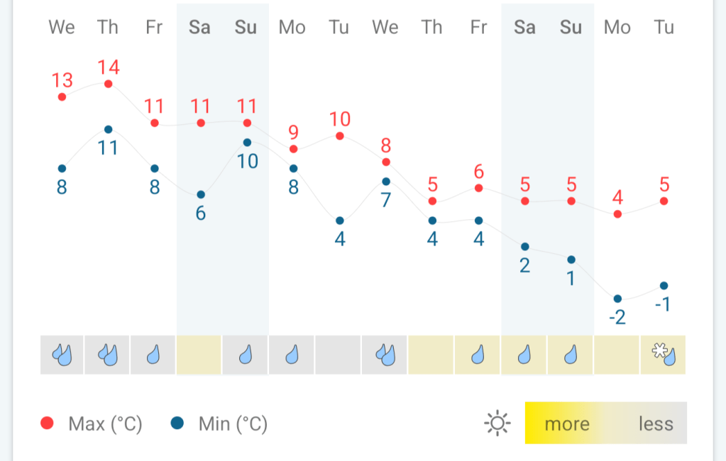
Thursday: It’ll be a very mild day with moist southerly winds. The day will start cloudy with bits and pieces of rain here and there and some more organised rain around lunchtime. A drier slot then more rain into the evening. This weather-front is a cold front so overnight it will become a little bit cooler. Max 15°C Min 9°C

Friday: A cloudy start with a few showers, but it should improve a little bit into the afternoon with some bright spells, but I can’t rule out it remaining dry everywhere. Quite a brisk westerly wind and cooler than yesterday. Max 11°C Min 7°C
Weekend: More rain but hopefully most will come overnight.

Saturday: Generally cloudy with a few bright spells. The cloud will thicken further as the day progresses and rain is expected late in the day and overnight. Again, it will be very mild for the time of year and breezy. Max 13°C Min 9°C
Sunday: Sunday could well start with a bit of rain which will move away quite swiftly and then it should be a drier day with the odd bright spell and again another mild one. The cloud will thicken further as the day progresses and rain is expected late in the day. Temperatures down just a notch as winds swing more west-to-northwest later. Max 12°C Min 7°C
Outlook: We start the working week with mostly cloudy skies and a few batches of showers. A brief ridge of high pressure should allow for a day or a couple of days of drier weather midweek but then it looks to turn a little bit cooler and possibly even colder towards the end of the month with a risk of wintry showers. The colder end to February and start of March is not certain so look out for updates on X. I’m sure winter’s not done with us yet.
Follow at @Chadweather on X for the latest forecasts and warnings.
Thanks,
Jon
Forecast Issued: Wednesday the 14th of February 2024 at 4:40pm.
Images: http://www.wxcharts.com, my Weather Station Data and the Weather&Radar app.