Unsettled at times – Thursday 29th June 2023 – Sunday 2nd July 2023

Hi all,

June, UK-wise, is set to be the warmest (hottest!) on record despite the month ending with temperatures down and fresher days around. I’ll post some statistics next week to see how it fairs locally to the previous Junes.

There are winners and losers when it’s hot and humid. Some of you love it but personally it’s too much, especially when trying to sleep. So I’m grateful of the recent fresher conditions, although some days have still been muggy despite the cloud and drizzle. I do miss the sun however and that’s making a return on Thursday.

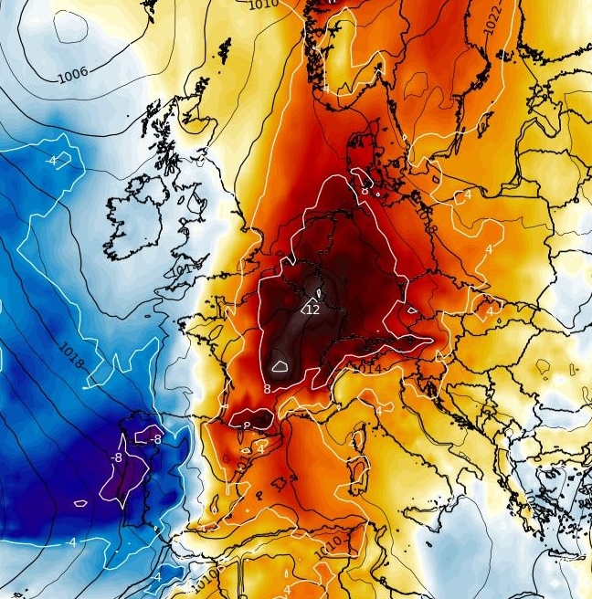
There isn’t any sign over the next two weeks of a heatwave returning, but, long-term model runs suggest a warming mid-July; but of course we take that with a pinch of salt at this range. Meanwhile, next week will see the Jet Stream bringing weather systems in off the Atlantic so rain will be around at times.

Remember, when sunny, the UV levels are still HIGH or VERY HIGH.

Fresher air this weekend.

Thursday: A fresh start but a sunny one. Fair-weather cloud will bubble up during the day with just the low risk of an isolated shower. Quite breezy and feeling fresher after a couple of days of muggy air. Max 18°C Min 10°C

Friday: Bright start then cloud will once again thicken and spread in from the west. Patchy drizzle is likely later in the afternoon with patchy rain arriving into the evening. Turning reasonably humid once again, therefore a warm night. Max 18°C Min 15°C

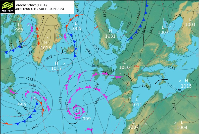
Weekend: Low pressure drives the weather.

Low pressure to bring a showery theme this weekend, especially on Saturday.

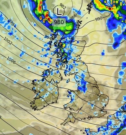
Saturday: Low pressure will bring a day of bright spells and showers. It will be windy with 30mph gusts. Later in the day there could well be a more prolonged spell of rain. Fresher. Max 18°C Min 12°C

Sunday: Windy once more, locally gusting to 35mph. Mostly cloudy with the odd shower. Max 17°C Min 12°C

Maximums temperatures over the weekend and into next week are much lower than we’ve been used to over the last few weeks.

Outlook: Little change into the start of the week and that looks to be the norm for the first 10 days of July; windy, showery and temperatures about average or below. There is some support in the models for the latter part of the 2nd week of July to turn very warm or hot once again. This is certainly not set in stone and as always subject to change at this range but as you’ve seen it’s prompted the media to start posting about 40°C and days upon days of a heatwave. This for now, is nothing but clickbait.

Above average temps close by over in the near continent as we enter week 2 of July. Will we see this pattern later in the month?

Follow @ChadWeather on Twitter for the latest forecasts and warnings.

Thanks,

Jon

Forecast Issued: Wednesday the 28th of June 2023 at 5:40pm.

Images: http://www.wxcharts.com & http://www.theweatheroutlook.com

Becoming increasingly humid with warm nights but a fresher outlook – Thursday 22nd June 2023 – Sunday 25th June 2023

Hi all,

Despite the heatwave ending it’s stayed quite humid at times and temperatures have remained into the 20s with some very warm sunny spells; but importantly, we’ve had some welcome rainfall, with some areas seeing up to 2 inches from the torrential thundery downpours.

One particularly notable thunderstorm pushed through the region during the early hours of Sunday morning, which produced some superb thunderbolts.

Volume up: Thunder from around 3am on Sunday morning 😍

Thursday: A cloudy start then some very warm sunny spells will break through. Clouds will bubble up and there will be a thundery shower or two, more so in eastern parts. Temperatures up a notch on Wednesday. Warm night ahead. Max 24°C Min 16°C

Friday: We introduce some moisture on Friday as a weather-front, albeit weakening, comes in from the west. So a mostly cloudy day after a bright start. Some light rain possible, but most look dry, a little breezy and we ramp up the humidity. A very muggy night to come despite the day being cooler on the thermometer. Max 22°C Min 17°C

Weekend: Very warm & humid. Thundery Sunday afternoon?

Saturday: A cloudy start is expected but cloud should break and sunny spells appear from the south. Temperatures will rocket and it will feel very warm to hot. There will be a refreshing and often gusty wind. Another uncomfortable night for sleeping. Max 25°C Min 17°C

Dew points of 17 or 18°C expected on Saturday = very muggy

Sunday: Breezy but a mostly sunny morning. Cloud is expected to increase into the afternoon with showers breaking out as another weather-front comes in from the west. A bit more of a kick to this one, so some lively showers/thunderstorms could be on the cards. A little cooler, eventually. Max 23°C Min 14°C

The ingredients look right for a thundery end to the humid and muggy spell later on Sunday.

Outlook: High pressure to our south-west and low pressure to our north-west looks the likely set-up meaning we will pick up a westerly airflow, perhaps north-westerly at times, allowing maximum temperatures to slip away to around 20°C. Winds will be quite gusty. Bright or sunny spells expected as well as a few showers, which could be beefy.

More prolonged spells of rain are possible later in the week as the Jet Stream takes control of our weather. Thankfully it won’t be anywhere near as muggy, which will be especially noticeable at night.

Follow @ChadWeather on Twitter for the latest forecasts and warnings.

Thanks,

Jon

Forecast Issued: Wednesday the 21st of June 2023 at 8:39pm.

Images: http://www.wetterzentrale.de

Heatwave to end with showers increasing – Thursday 15th June 2023 – Sunday 18th June 2023

Hi all,

The dry spell has come to an end, but only for those who caught the thunderstorms. There have been vast differences in what fell across parts of the region this week as those thunderstorms arrived. I’ve only measured 1.6mm whereas others, like Hindley and Hartcommon Golf Clubs, measured 38 and 40mm. That’s what we would expect over 2 weeks in June.

Hartcommon Golf Club, Hindley, Wigan (@HartCommonGC on Twitter) – 40mm from the thunderstorms on Monday evening.

Over the last day or so we’ve picked up an easterly breeze, which has not only been gusty but has brought slightly lower temperatures and a less muggy feel at night as the humidity and dew point dropped. Unfortunately for those who hate the sticky nights, they are set to return as the moisture in the air increases and winds ease.

HIGH UV levels and HIGH to VERY HIGH pollen levels throughout the 4-day forecast.

Thursday: Another stunning day with plenty of hot sunshine. Not as windy as recent days, so temperatures lifting a degree or two. Fair-weather cloud will bubble up during the afternoon but I will be very surprised to see any showers. A warm night. Max 27°C Min 15°C

Friday: The high pressure that’s kept us sunny for the last few days will start to lose a bit of its grip and winds will swing south or south-easterly allowing it to become more humid. With a bit more instability, the cloud that bubbles up later in the day is likely to set off a sharp shower. Stuffy night awaits. Max 26°C Min 17°C

Weekend: The heatwave ends and could the heavens open again.

Saturday: Low pressure will be nudging closer from the south-west, similar to a week ago. So, more in the way of cloud after a sunny morning. Scattered showers into the afternoon, some thundery with torrential downpours. Max 24°C Min 16°C

Sunday: Definitely looking more unsettled with showery rain or thunderstorms spreading up from the south-west. Cooler on the thermometer but it will be feeling close. Max 23°C Min 16°C

Thunderstorms set to return later this weekend but not expected to be as severe as earlier in the week.

Outlook: With maximum temperatures now going below 25°C, the heatwave has ended. That said it looks set to remain warm and muggy at times with a risk of occasional thundery showers. Temperatures should stay in the early-20s and thankfully a little less warm at night. Some computer models suggests another heatwave towards the end of the month as heat wafts up from the south. It’s too early to say will it or won’t it, and more often than not, these plumes get shunted east.

Follow @ChadWeather on Twitter for the latest forecasts and warnings.

Thanks,

Jon

Forecast Issued: Wednesday the 14th of June 2023 at 7pm.
Images: http://www.wxcharts.com

Becoming humid with the chance of thunderstorms. Muggy nights – Thursday 8th June 2023 – Sunday 11th June 2023

Hi all,

It’s now 20 days without measurable rainfall and any rainfall expected over the next ten days will come in the form of showers, which can be very localised, so that count will continue for some. Our weather is changing as we enter the weekend and you’ll certainly feel the difference, especially at night.

HIGH UV levels (7-8) through the forecast….

Thursday: Early cloud will again take time to clear away from west to east. Some sunny spells into the afternoon and still that steady north-easterly breeze. Max 19°C Min 8°C

Friday: Plenty of sunshine on offer again with a breeze but it will again start cloudy. Starting to feel a little more humid later. Becoming windier with 30mph gusts, as the isobars tighten, signalling change. Max 21°C Min 9°C

Humid air and also some instability is moving up from the SW for the weekend.

Weekend: Muggy with the risk of thunderstorms. Warmer nights noticeable.

Saturday: The recent high pressure will now have slipped away to the north-east and allow low pressure to push a little closer to the UK. This will also bring us a south-easterly/southerly airflow and introduce a much different feel to the weather, especially at night as the humidity rises. Sunny spells for the morning with cloud bubbling up into the late-afternoon and evening as thundery showers pose a risk from the south-west. Breezy. Max 25°C Min 14°C

Dew point values by Saturday evening indicating how much more humid it will feel.

Sunday: Bright spells and scattered thunderstorms. Muggy and not the best for sleeping . Max 24°C Min 15°C

Outlook: Staying warm, temperatures nicely into the 20s, with some sunny spells but with slightly instable air still in place, showers, thundery at times, are possible, but these will be hit-and-miss.

Total rainfall over the next 7 days. Clear to see that the high pressure has shifted ENE allowing showers to deliver some rain to the UK after weeks of dryness.

May 2023 Stats

Max 22.1°C (27th)
Min 6.2°C (4th)
Av. 13.0°C
Wettest 6.6mm (11th)
Av. Humidity 76%
Av. Barometer 1024.4 hPa
Max Gust 32.2mph
Av. Wind Direction NNE
Rain 23.6mm (39% of average)
Rain Registered Days 9
Dry Days 22

Follow @ChadWeather on Twitter for the latest forecasts and warnings.

Thanks,
Jon

Forecast Issued: Wednesday the 7th of June 2023 at 9:40pm
Images: Met Office | http://www.meteologix.com | wxcharts.com