Cold and frosty for the foreseeable and no significant snowfall likely – Thursday 30th November 2023 – Sunday 3rd December 2023

Hi all,

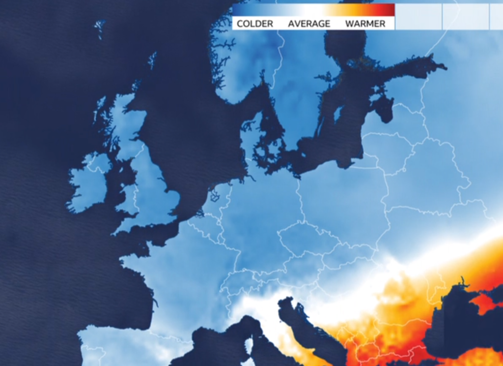
Winter officially, and meteorologically-speaking, starts on Friday and we enter it with temperatures well-below average and with a moderate frosts on the go, but, snow is what we all want, yeah? Well it’s not everyone’s favourite ingredient and it looks like this lengthy cold spell is going to be wasted when it comes to a decent snowfall.

Remember to ignore the fake news when it comes to the media and snowfall. It’s a circus out there.

Thursday: Cold and frosty with some localised mist or fog which might be slow to clear. Otherwise dry with sunny spells. A little breezy. Max 3°C Min -4°C

Friday: Similar pattern continues. Sunny by day, once fog/low-cloud lifts, frosty by night. Dry. Max 3°C Min -4°C

Weekend: Perhaps more in the way of cloud with the chance of some wintry showers.

Not much precipitation expected over the coming days with most of the wintry showers affecting the coasts. Any that drift inland will fall as sleet or snow.

Saturday: Early freezing fog will clear to bright or sunny spells but some wintry showers, snow above 150M, could be knocking around. Hard to say at this stage but more possible than earlier in the week. A bitter day. Max 2°C Min -3°C

BBC Weather: Most of Europe colder-than-average this week

Sunday: Cloudier with some bright spells and again the chance of some scattered wintry showers. Nothing significant. Max 3°C Min -2°C

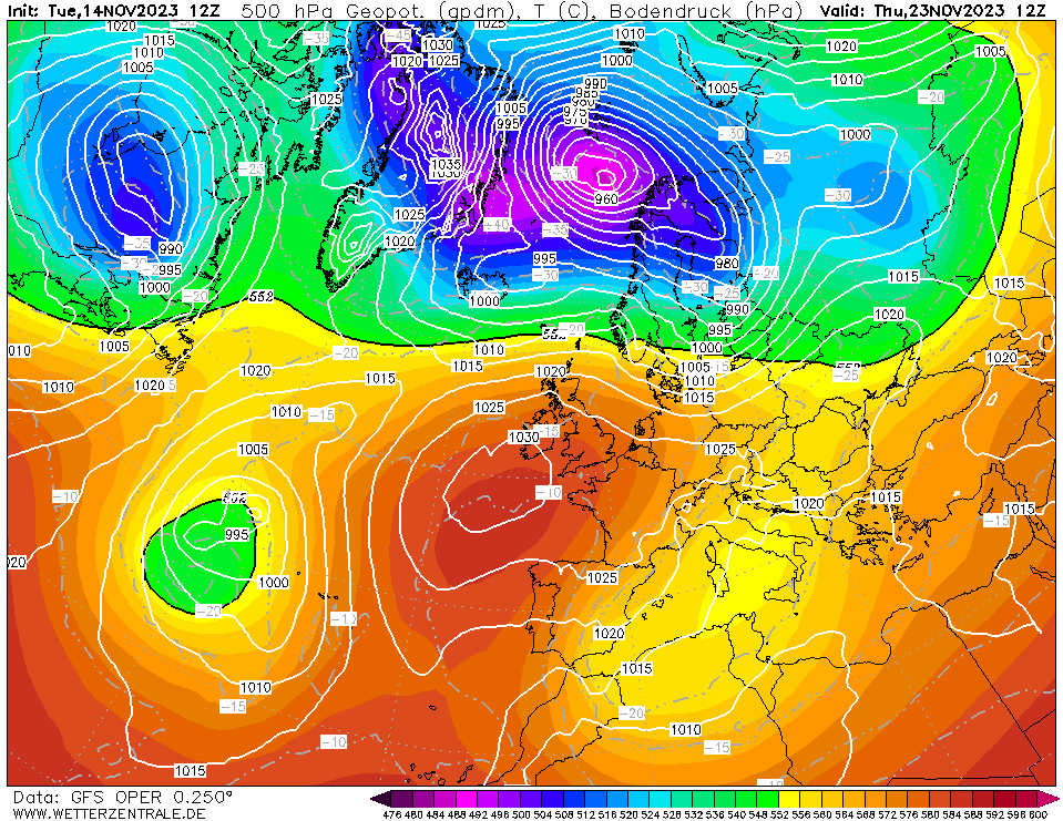
Outlook: We remain in the cold air, so more frosts to come but currently the models show a change will arrive around the 6th/7th of December, as we switch to a more south-westerly airflow bringing less cold air and eventually some rain and wind. It will have been a cold start to winter and disappointing to not have taken advantage of this and had some decent snowfall. Knowing our winters, the next cold spell will be March 😂.

Turning less cold as we enter the second week of December

Follow @ChadWeather on X for the latest forecasts and warnings.

As always thanks for reading.

Thanks,

Jon

Forecast Issued: Tuesday 28th November 2023 at 7:38pm

Images: http://www.wxcharts.com & BBC Weather

Cold spell coming but will it last? – Thursday 23rd November 2023 – Sunday 26th November 2023

Hi all,

Still no 600-feet tall wall of snow on the way 😀 but our first cold snap as winter approaches is. Northerly winds will bring frost(s) and clearer blue skies with welcome sunshine but more importantly we’ve lost the relentless rain with high rainfall totals.

Tuesday was only our second day this month without measurable rainfall. So we need a break. There is still some rain around in this forecast but the general theme ahead is drier.

Only 2 days without rainfall so far in November

Thursday: A windy (30mph gusts) and cloudy day with some patchy rain. A more organised band of rain will sink south on a cold-front into the evening, pushing away the mild air and temperatures will fall away. Max 12°C Min 4°C

Colder air sinks south Thursday evening
Spot the cold-front sinking south on Thursday evening

Weekend: Cold but milder air to return?

Friday: Cold Arctic air will slowly filter south, and with the windchill it will feel like a couple of degrees above freezing. The north-westerly wind will be gusty at times. Sunny spells with some cloud, especially out west. Clear skies and lighter winds overnight will lead to a frost forming. Max 6°C Min -2°C

A frosty Friday night on the cards

Saturday: A frost to start then a cold but dry day with sunny spells and lighter winds. Frost likely to set in again into the evening and first part of the night but cloud could well lift temperatures later in the night. Max 5°C Min 0°C

Sunday: Depending on cloud-cover it could be another frosty start in places. Cloud is expected to topple down from the north-west making any sunshine hazy then lead to a cloudy afternoon. With the lack of sunshine it will feel cold still, despite less cold air feeding in. Patchy rain possible later into the evening. Max 6°C Min 3°C

Outlook: What the weather brings next week, is not certain. It’s more favourable to turn slightly milder again from the west with some showery rain and with some colder spells from the north-west.

But, some computer models today are signalling for an easterly wind to set in. Less likely to happen but if it were to lock-in, it will become much colder with a sharp wind, and perhaps cold enough for a few snow flurries. For updates on this, look out for my posts on X.

Could we see an easterly airflow arrive as we head towards the start of winter

Follow @ChadWeather on X for the latest forecasts and warnings.

Thanks again for reading.

Jon

Forecast Issued: Wednesday the 22nd of November 2023 at 12:32pm.

Images: http://www.theweatheroutlook.com & http://www.wxcharts.com

Yet more rain but drier and brighter hopes on the horizon – Thursday 16th November 2023 – Sunday 19th November 2023

Hi all,

After a briefly colder, drier and brighter spell we’re back to awful rain and wind. Luckily for us, we missed out on the really strong winds brought by Storm Debi but parts of the region to our west and north did see 60-70mph.

Wind chart for Storm Debi at Chadderton HQ

The amount of rain is a concern with golf courses closed and gardens saturated. When will it end? Well, just maybe, high pressure will build in, in a week’s time. Please, we need this.

November 2023 so far……

Just 1 dry day this month

Thursday: A chilly day with a northeasterly breeze. Mostly cloudy too with some rain arriving into the late-afternoon/evening. Max 8°C Min 5°C

Friday: Early rain then it should become drier and brighter into the afternoon. Similar temperatures. Max 9°C Min 5°C

Weekend: Unsettled with more rain to come.

Saturday: A cloudy and windy day in prospect as heavy rain moves in from the southwest. This will turn more showery and drizzly into the afternoon. Milder than recently. Max 12°C Min 9°C

Sunday: More rain but showery in nature. Again mild and windy. Max 12°C Min 8°C

Outlook: As we head into next week and the final third of November the weather will become cooler, but not that cold, more seasonal shall we say. There will still be some showers around but there is a hint of high pressure trying its best to build from the south-west to give us a respite from the relentless rain and breezy conditions.

Hopefully not so wet to see out the last week of November

Follow @ChadWeather on X for the latest forecasts and warnings.

Thanks,
Jon

Forecast Issued: Wednesday the 15th of November 2023 at 4:45pm.

Image: http://www.wetterzentrale.de/en/ & my weather station data

Dodging Storm Ciarán – Thursday 2nd November 2023 – Sunday 5th November 2023

Hi all,

I mentioned last week about the possibility of another named-storm this week and Storm Ciarán was named a few days ago. It will bring some destructive winds but luckily for most of the UK, these will be in northwest France and the Channel Islands, where we could see gusts of over 100mph.

Damaging gusts in Jersey

We will dodge the bullet, but the storm will bring us a spell of rain and reasonably gusty winds overnight Wednesday. But overall, it will be a non-event for us.

However, with us being close to the centre of the low we could see some record low pressure values being recorded.

My current record is 961.16mb in February 2014, where incidentally I recorded my strongest ever gust on this day too, of 72mph. Thursday morning is forecast to bring the pressure down to 959mb, so it’s going to be close.

I’ve seen the usual suspects in the media predicting, freezing temperatures and snow. There is currently no sign of this happening, so as usual ignore the clickbait.

So, what is the forecast for the next 4 days?

Thursday: Storm Ciarán will be battering parts way to our south but it’ll be nothing but a breezy one for us after a windy spell during the early hours. It will then be a day of showery rain coming and going, some heavy bursts and some drier spells in between. Feeling cool. Max 10°C Min 7°C

Storm Ciarán to our southeast on Thursday morning – this deep area of low pressure could bring a record low pressure reading for my station.

Friday: A better day but breezy. Cool winds and bright spells and a few showers. Max 10°C Min 5°C

Weekend: Chilly.

Saturday: I’m hopeful for a mostly dry morning albeit quite cloudy, with patchy rain arriving for the afternoon on an easterly breeze. Cool. Max 9°C Min 5°C

Sunday: Bright spells and scattered showers. Max 10°C Min 7°C

Outlook: Remaining showery with south-westerly winds which will be gusty at times. Nothing significantly colder or milder. Hard to find a dry day.

Plenty more rain to come over the next 7 days

Follow @ChadWeather on X for the latest forecasts and warnings.

As always, thank you for stopping by to read my weekly blog.

Thanks,

Jon

Forecast Issued: Wednesday the 1st of November 2023 at 5:50pm.

Images: BBC Weather & http://www.wxcharts.com