Low pressure continues to dominate – Thursday 28th March 2024 – Bank Holiday Monday 1st April 2024

Hi all,

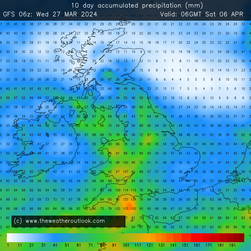
It’s time for April showers, albeit ahead of schedule. The rain is set to keep on coming, mostly via the form of showers. It won’t rain all of the time and there will be some brightness in between, so grab it when you can. Look out for some hail, amazing clouds and rainbows over the coming days and even listen out for some thunder as towering shower-clouds form. 

UV levels are now medium and there is certainly some warmth in that sun – when it decides to come out that is!

Despite unsettled conditions we will be slightly milder than average this weekend. Parts of eastern Europe will see temperatures into the mid-20s.

Thursday: An area of low pressure, named Storm Nelson (by the Spanish Met Service) will swing up from the southwest bringing an unsettled day with windy conditions, bright spells and frequent hefty showers, especially early on and later in the day. The showers could be thundery and with hail. Max 10°C Min 4°C

Good Friday: The showers will continue but they are expected to be a bit more scattered but still beefy and thundery, fuelled by the warmth from the sun. Bright spells in between and a little milder. Max 13°C Min 5°C

Lower than average pressure dominates western Europe this weekend

Long Weekend: Temperatures rising a notch and showers decaying as the low fills but will it be replaced by another?

Saturday: Sunshine and showers. Showers fewer and further between but still heavy if you catch one. Feeling pleasant in the increasing-in-strength sunshine. Max 14°C Min 6°C

Sunday: The low pressure will start to fill so showers should become isolated then fade. Some brightness. Lighter winds and feeling pleasant if you catch any sun. Mild. At this stage it looks like the best day of the holiday. Max 15°C Min 7°C

Showers close on Sunday but it does currently look the better day of the long weekend

Bank Holiday Monday: It currently looks like a settled day but with heavy showers not too far away to our west and south-west. So, today’s forecast is likely to change. A little bit cooler with an easterly airflow. Max 13°C Min 6°C

Outlook: It looks like we will still have low pressure anchored to our south-west throwing up bands of showers or rain at times. Brighter and drier interludes in between. No sign of anything settled or a prolonged drier spell with warmer temperatures. Our environment needs a couple of drier weeks for sure.

Yet more rain in the forecast. From today (Wednesday) we’re expecting to see 2 inches of rain over the coming 10 days.

Follow @ChadWeather on X for the latest forecasts and warnings and for daily updates.

Thanks as always for stopping by to read my weekly blog and for your interactions on X. I hope you all have a lovely Easter.

Jon

Forecast Issued: Wednesday the 27th March 2024 at 5:37pm.

Images: http://www.wxcharts.com & http://www.theweatheroutlook.com

A colder end to March and yet more rain but will high pressure welcome in April? – Thursday 21st March 2024 – Sunday 24th March 2024

Hi all,

The rain keeps coming and after a 7-day dry spell earlier in the month we’ve now had a 9-day wet spell of weather with approx. 1 1/2 inches of unwanted rain. Despite that, it has been mild to very mild but winds are set to turn to a colder direction as we bring March to a close.

March 2024 so far
Colder-than-average temperatures for the last week of March

Thursday: A better day than yesterday, with mostly cloudy skies, but the cloud will be thin enough at times to allow a few hazy sunny spells to come through. The last milder-than-average day to come this week. Chance of the odd light shower especially later. Max 13°C Min 8°C

Friday: A cold-front will have moved through and with it cloudy skies and some patchy rain. Skies should brighten and it will turn cooler with winds swinging to the northwest. Plenty of sunny spells on offer but convection in the Irish sea will feed in some showers as the day progresses which could be wintry on the hilltops. A much colder-feel especially in the gusty wind. Max 9°C Min 3°C

Weekend: Sunday looks best.

Saturday: A windy and cold day with frequent showers. These will be heavy at times with hail and thunder possible. Bright spells in between. Max 8°C Min 4°C

Total rainfall expected between now and Monday. Most of the rain coming via a showery theme.

Sunday: Drier with any early showers becoming confined to the east of the Pennines. Some sunny spells breaking out and winds eventually easing. Still chilly. Max 10°C Min 4°C

Cold enough for wintry showers on the highest ground later this month. Snow on the mountains. Nothing unusual for the time of year. Nothing to trouble us so ignore the clickbait media nonsense.

Outlook: It’s favourable that it turns a little cooler for the final week of March with some chilly nights and showers, some beefy and thundery with hail by day. Temperatures returning to normal for the last couple of days, perhaps back close to the mid-teens before we enter April. No sign of anything significantly warm yet. I wonder if we’ll see the first 20°C of the year in April or May?

The 10-day total rainfall map doesn’t make for good reading with plenty more rain to come. We desperately need a break. Grass roots pitches, golf courses and cricket pitches are saturated.
High pressure showing on the charts to start April. Only problem with this is, this time-frame isn’t reliable and will likely chop-and-change, but for now we can cross those fingers.

Follow @ChadWeather on X for the latest forecasts and warnings.

Thanks,
Jon

Forecast Issued Wednesday the 20th of March 2024 at 5pm.
Images: http://www.tropicaltidbits.com, http://www.wxcharts.com & http://www.theweatheroutlook.com.

Staying mostly mild with occasional rain – Thursday 14th March 2024 – Sunday 17th March 2024

Hi all,

Our dry spell earlier this month was not long enough as we still have plenty of saturated ground to drain. We will see further spells of rain over the next 7-10 days but I can’t see a day with very high rainfall amounts, so hopefully with it being spread out it won’t cause too much further localised flooding.

Thursday: Cloudy with a spell of rain during the first half of the morning, then a drier slot but remaining mostly cloudy. Showery rain will return mid-afternoon with some gusty winds. Despite the wind it will feel very mild. Max 14°C Min 8°C

Friday: The odd bright spell but there will also be showers which could be quite heavy at times and thundery. As the afternoon progresses, the showers should ease away and winds will swing to the northwest and it will become cooler. Chilly overnight. A touch of ground-frost overnight cannot be ruled out. Max 10°C Min 3°C

Briefly colder Friday PM/Saturday AM

Weekend: Further rain and milder again.

Saturday: A fresh start then most of Saturday doesn’t seem too bad, but from mid-afternoon, after a few bright spells during the morning, cloud will become thick enough and showery rain will arrive from the southwest, especially so into the evening. Not as windy as recent days. Milder overnight. Max 10°C Min 9°C

Sunday: A bit windier and milder and again another mostly cloudy day with showers at times. Max 13°C Min 7°C

Outlook: The first few days of next week, Monday to Wednesday, look to be mild with temperatures of around 13°C. With all that moisture, there’s still bound to be a few showers around. Once an area of low pressure clears, we will drag in some northerly winds for the second half of the week, meaning it will become cooler with temperatures dropping to around 9 or 10°C. Some chilly nights, but there’ll be some welcome sunshine around and the odd scattered shower.

A much colder spell in March with snow is not unusual but there is no sign of it happening this year. It would be nice to have a settled spell of weather again, after 8 dry days earlier this month, and with some warmth, but there is no sign of that either as we remain mixed and unsettled.

Cooler again later next week?

Follow @ChadWeather on X for the latest forecasts and warnings.

Thanks,

Jon

Forecast issued: Wednesday the 13th of March at 8:45pm.

Images: http://www.wxcharts.com

Becoming windy with a brief return to rain looking likely – Thursday 7th March 2024 – Sunday 10th March 2024

Hi all,

Finally, we’ve had a break from the relentless rain and unsettled conditions. This week, we’ve seen some pleasant sunshine as we entered the season, meteorological-speaking, of Spring. It’s felt quite warm in the sunshine and sheltered from the breeze and even lawns are being cut. But, although we’ve still had a few frosts, the main plus, has been drier days. But, will this theme continue, as low pressure threatens from our south.

4 dry days in-a-row. Much-needed!

Thursday: More cloud is expected compared to recent days and also the wind is likely to increase as the day wears on to become particularly gusty. Some bright spells around but a bit more of a disturbance in the atmosphere is likely to mean we see a few showers cropping up late-afternoon. Feeling cool in the wind. Max 10°C Min 4°C

Friday: Overcast to start then some sunny spells breaking out here and there. Notably windy with a gusty easterly, to 35mph at times. Feeling chilly in exposure to the wind. A dry day is expected and no frost overnight as cloud rolls in from the south-south-east. Max 9°C Min 4°C

Weekend: Cloudier. Risk of rain returning.

Saturday: A mostly cloudy and windy day with the cloud thick enough at times for some patchy rain or drizzle. Hopefully a bit drier later in the day. Max 10°C Min 6°C

Sunday: Cloudy with some rain or drizzle around in the morning which should ease away into the afternoon. Brightness looks limited. Again, windy taking the edge off the temperature. Max 9°C Min 5°C

Outlook: Western parts of the UK will become more unsettled with showers or longer spells of rain. These weather-fronts will try their best to move into the region but a battle could be on, as high pressure to the east/north-east holds firm. If this high holds out then we might not see much in the way of a lot of rain next week as the GIF below shows. Fingers crossed for another low rainfall total week. Temperatures around average though and no frosts expected. Any winter-like weather looks like it’s done with {famous last words}.

Total rainfall expected over the coming 7 days.
Weather-fronts out west trying to make their way east again next week but coming up against a huge area of high pressure. As it stands we should be on for below-average rainfall amounts next week.

Follow @ChadWeather on X for the latest forecasts and warnings.

Thanks,

Jon

Forecast Issued: Wednesday the 6th of March 2024 at 6:34pm

Images: http://www.wxcharts.com