
Hi all,
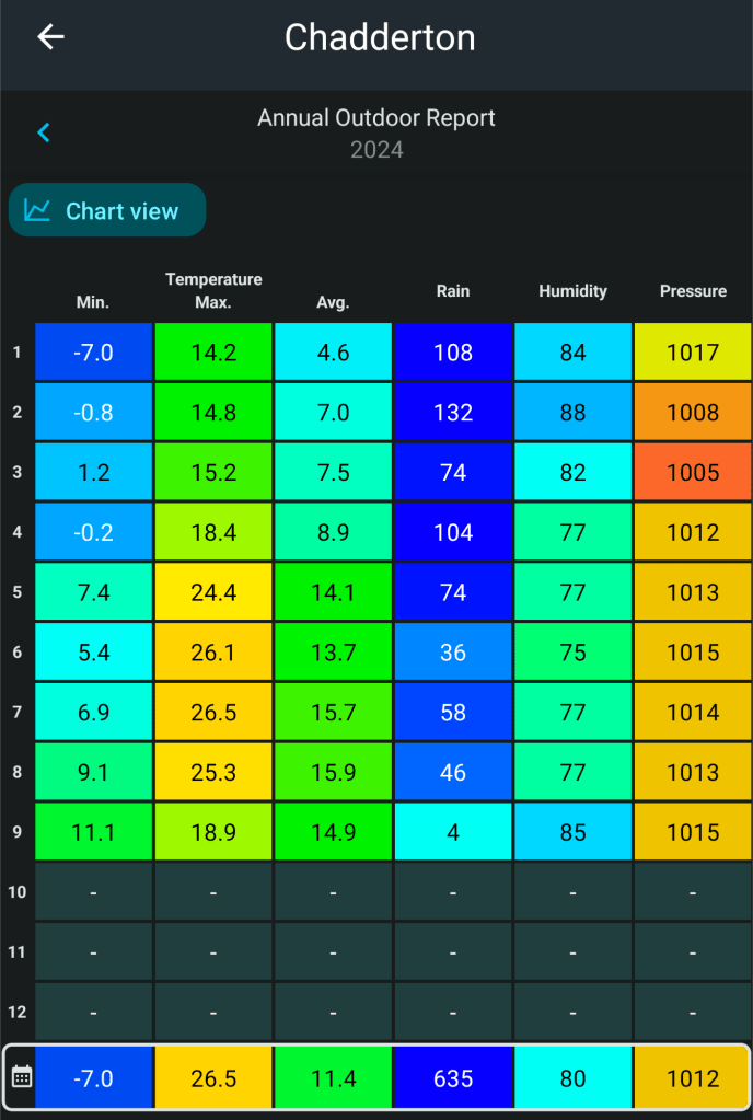
Summer has come to a close. I need to pull my finger out and get my data all sorted so I can compare seasonal data with ease. But, as you may have seen, summer was cooler-than-average, the coolest since 2015 and also drier-than-average. And to top it off, duller-than-average too. All 3 months in fact, had below-average rainfall after a wet Spring.
Thursday: Interesting set-up with a cut-off low pressure sitting to the south of the UK. This means we will see a northeasterly airflow. The low will deliver a wet day to our south. For us, some sunny spells, windy at times and any sun/brightness turning hazy as cloud increases from the south. Feeling cool in the wind but turning humid later. Showers possible overnight. Max 19°C Min 15°C
Friday: Another windy day, with gusts of 30-40mph not out of the question. Despite the wind it will be sunnier with some decent spells of sunshine expected and temperatures will rise rapidly, as will the muggy-feel to the weather, especially at night. Max 24°C Min 16°C
Weekend: Not all plain sailing.
Saturday: Overnight showers may have pushed up from the south but once these clear it should be a day of sunny spells and again windy conditions but not as gusty as Friday. Temperatures down a little. Max 22°C Min 15°C
Sunday: Looks a similar day to Saturday but with the showers coming during the daytime. Odd one could be heavy and thundery. Breezy. Max 21°C Min 14°C
Outlook: Littered with uncertainty but it’s siding towards a more unsettled week, after early ridges of high pressure, and possibly cooler with a northerly airflow slipping in for a day or two later in the week. Overall not too much rainfall expected.
Follow @ChadWeather on X for the latest forecasts and warnings.
Thanks,
Jon
Forecast Issued Wednesday the 4th of September at 5:14pm
Images: http://www.wxcharts.com
