Sunny, warm but breezy at times. No rain. – Thursday 15th May 2025 – Sunday 18th May 2025

Hi all,

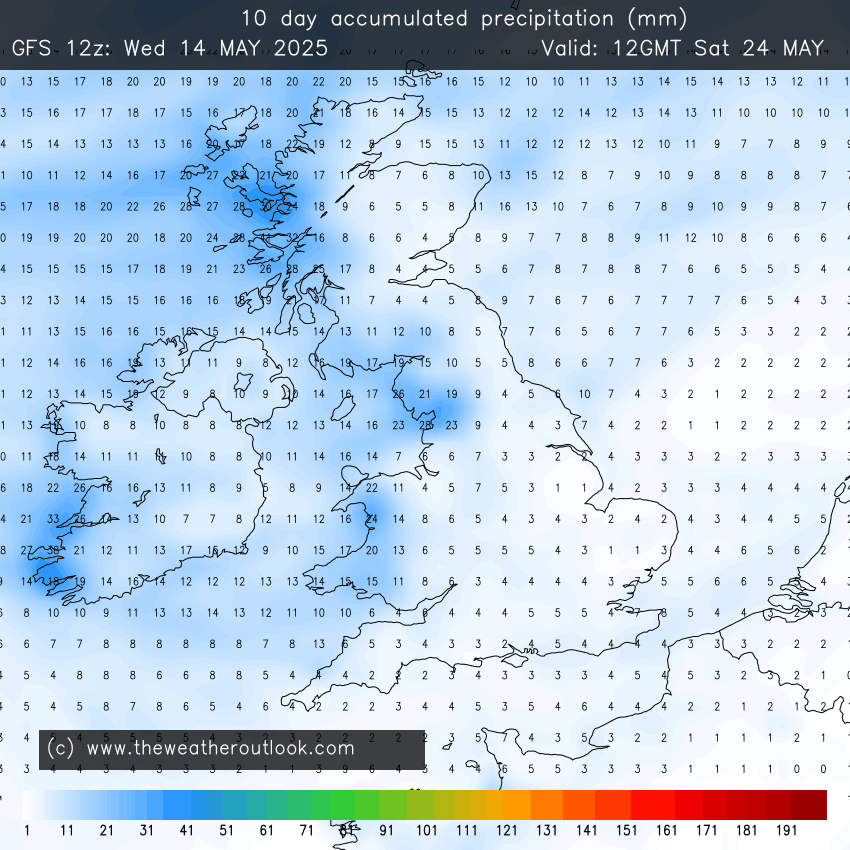
The “rainless” May goes on here. Yes I know we had some rainfall early one morning but it didn’t register, so the total for May still stands at 0mm.

Rainless May

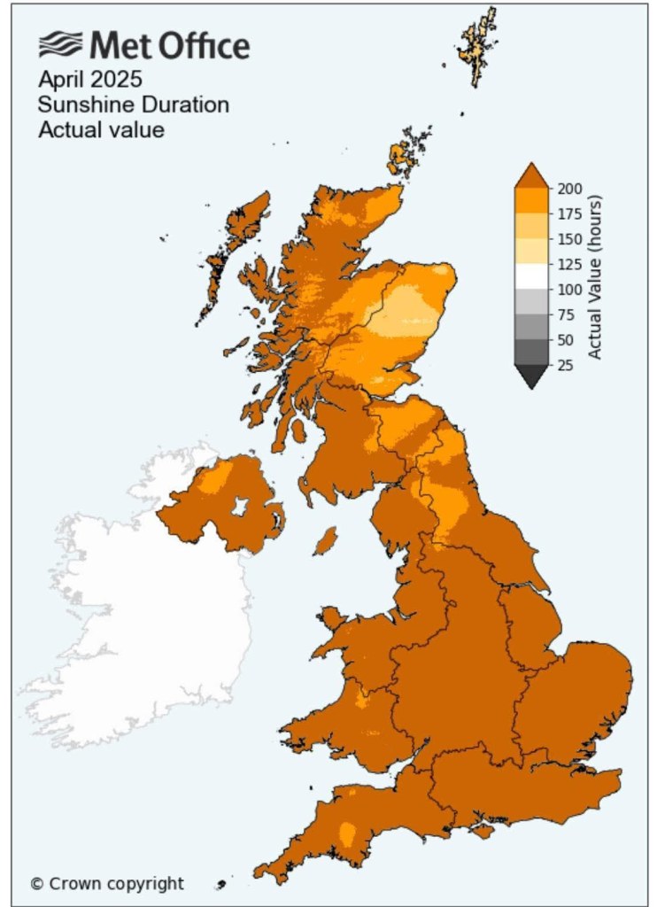
We (UK) are on course for the driest and sunniest spring ever recorded. It’s simply been an incredible season but places are getting desperate for rain now.

The local reservoir levels are at 56% compared to 83% this time last year.

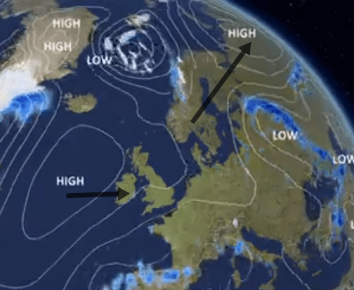
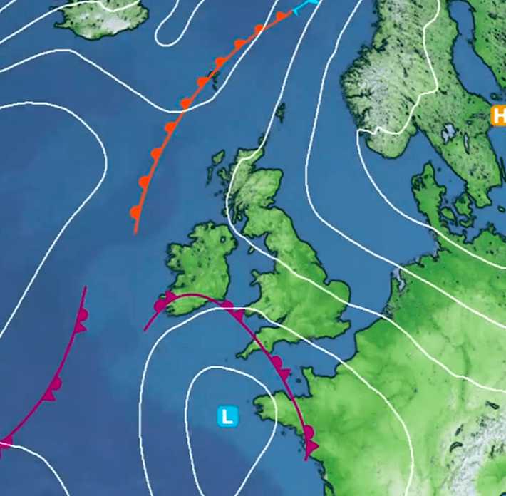
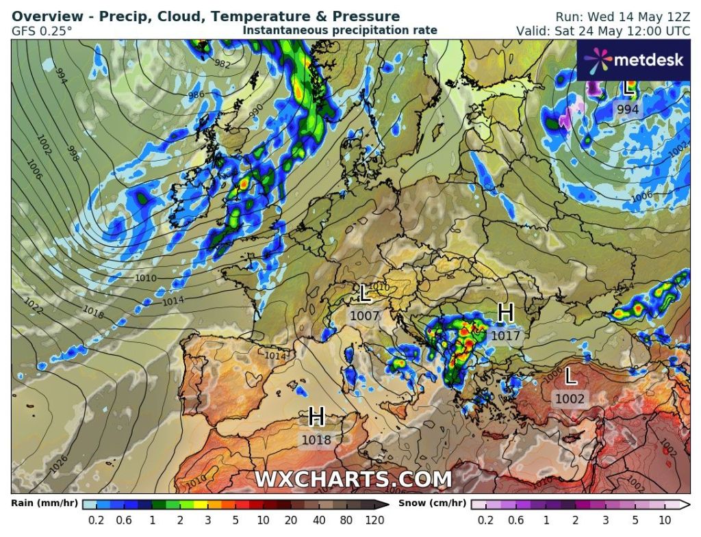
So when will it rain? Not for at least another week. There are signs however of low pressure replacing high pressure as we head towards the Bank Holiday weekend, typical, but it still remains to be seen if the low will be strong enough to oust the stubborn high.

Before that, plenty more of the same. Sunny skies, warm, dry and breezy at times. No sign of a heatwave for now, as the positioning of the high means we won’t be tapping into any hot air from the south.

UV levels are now HIGH 11AM TO 2PM.

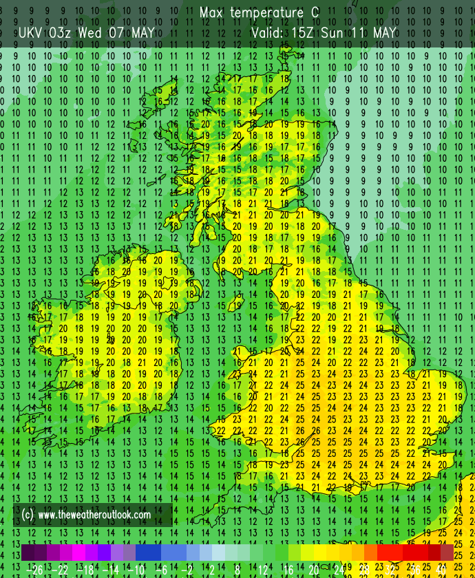
Thursday: Similar to Wednesday, there is a chance that we start the day with some low-cloud that has drifted in from the northeast. This will be a little stubborn to clear but it will burn off leading to another glorious day with plenty of sunshine. Winds a little gusty. Warmest in the west. Cool overnight where winds fall lighter.  Max 18-20°C Min 5°C Max Gusts 25mph

Some breezy days ahead

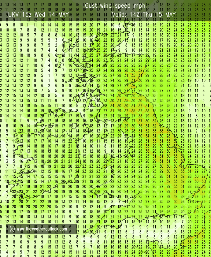
Friday: Temperatures rising a touch. Still windy though, more so into the afternoon. Dry and sunny. Max 22°C Min 7°C Max Gusts 25mph

Weekend: If you’ve not had a BBQ yet then what are you waiting for? Little change.

Saturday & Sunday: Might as well group these days together as they will be very similar. Plenty of sunshine, most likely wall-to-wall sunshine. Dry and again a breezy northeasterly. Max 22°C Min 8°C Max Gusts 20mph

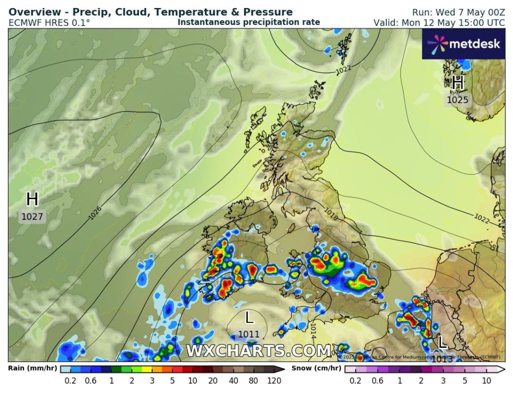
Outlook: It’s quite a simple outlook for most of the week as high pressure continues to stay in charge, bringing sunny skies and dry conditions. Temperatures sitting around 20°C. It’s later in the week, where the forecast gets a little bit tricky from this far out, but there are signs, which I’ve been hinting at for a few days now, that high pressure will slip away and low pressure will start to bring weather-fronts in from the west. We will finally see some rain and this could mean the final week of May brings unsettled conditions. One to watch for now and look out for updates on social media. The petrichor smell will be epic.

Changes around the 24th?
The 10-day total precipitation forecast shows rain amounts increasing from the west

Follow @ChadWeather on X and Bluesky for the latest forecasts and warnings.

Thanks,

Jon

Forecast Issued: Wednesday the 14th of May 2025 at 7:20pm.

Images: http://www.wxcharts.com & http://www.theweatheroutlook.com

Yet more dry weather and becoming warmer once again – Thursday 8th May 2025 – Sunday 11th May 2025

Hi all,

It’s turning out to be an amazing Spring with plenty of settled weather, also meaning it’s been very dry. It’s no surprise that we’ve had the sunniest March and April on record across the UK.

Sunshine stats from the Met Office for April

I’ve said it for a few weeks now. We need some rain. We are well below-average for Spring, sitting at 23% of the average rainfall, And yet again there is no sign of any significant rainfall amounts over the next 2 weeks.

High pressure, that has been in control of our weather this week, has been in a position to bring some cloud in from the North Sea, making it cooler at times. This cloud moves around the high so sunny spells have been coming and going.

Towards the end of the week, this high will slip away to the northeast and introduce a drier and warmer south-to-southeasterly airflow. Temperatures will respond. This will then be replaced by another high pressure that will slip in from the west as we head into next week bringing further dry weather and pleasant sunny spells.

Next week our high will slip away but in the back door comes another. Image: BBC Weather

It was a cold start to Tuesday this week, with a ground frost in many places and some places recording an air frost but this is not unusual for early-May, especially under the influence of high pressure, clear skies and light winds. A couple of chilly nights to come this week but from Friday the risk, for frost, for now has passed.

Thursday: Still variable amounts of cloud throughout the day so sunny spells one minute and then thicker cloud the next. Dry and with that high pressure starting to slip away there will be a keen breeze. Warmest in sheltered western parts. Max 18°C Min 5°C

Friday: Feeling much warmer with more in the way of sunshine and lighter winds. Very pleasant indeed. Max 20°C Min 6°C

Don’t forget your sun cream if you’re out and about in the sun for a lengthy period of time. UV levels are now up to HIGH around lunchtime and MEDIUM for most of the morning and the afternoon.

Weekend: Decent. One hand on the BBQ, one hand watering the garden .

Saturday: Some early mist and another great day, warm with sunny spells. Max 22°C Min 7°C

Sunday: With southerly winds in place and plenty of sunshine temperatures will lift and it will really feel like summer again. Some cloud could well bubble up enough later in the day/evening to produce an isolated shower or thunderstorm as the air gets a little bit of instability from a low pressure to the south of the UK. Max 22°C Min 9°C

Warmer this weekend but rain/showers will cool off the SW of the UK.

Outlook: There is an outside chance, later on Sunday and into Monday, of an isolated shower. Otherwise, the week will be dominated again by high pressure slipping in from the west, bringing plenty of sunshine and temperatures close or into the 20s °C. With us only having a quarter of our rainfall during March and April, we will now be 2 weeks into May without any significant rain.

Some instability, coupled with the warmth, could trigger some downpours on Sunday PM into Monday. One to watch for now.

If this continues, we could well start to hear the words drought or hosepipe ban mentioned in the news. It’s got to change at some point and I’m not complaining about the lovely weather, but we are definitely in need of some rain.

Thanks for stopping by to read. For more forecasts and warnings please follow @ChadWeather on X and Bluesky.

Thanks,

Jon

Forecast Issued: Wednesday the 7th of May 2025 at 6:06pm.

Images: The Met Office & http://www.wxcharts.com & http://www.theweatheroutlook.com & BBC Weather.