Turning unsettled with welcome rain returning as temperatures return to normal – Thursday 28th August 2025 – Sunday 31st August 2025

Hi all,

That’s a wrap. Summer 2025 is coming to an end and it’s been a decent one at that, although gardeners and greenkeepers would certainly have wanted more in the way of rain.

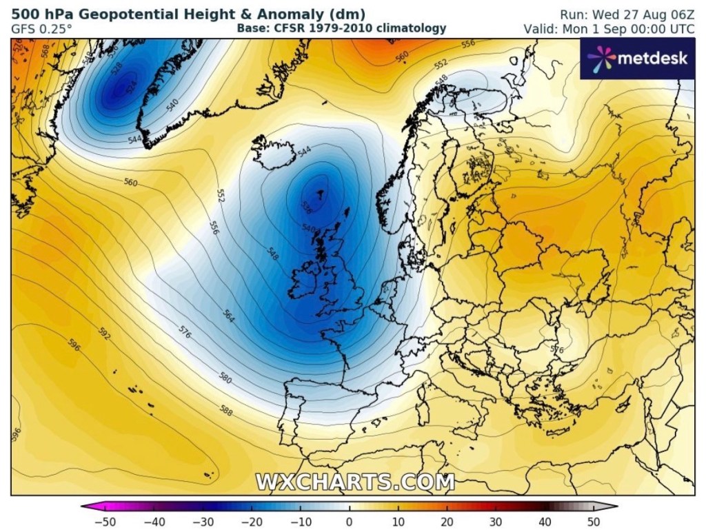
Meteorologically-speaking autumn begins on Monday and the beginning of September looks set to continue the theme that we are going to end August with, and that is unsettled conditions and bands of showery rain at times. So welcome rain is coming.

We do tend to see a very warm spell in September but at the moment there is no sign of this happening, and remember this is not called an Indian Summer. This is saved for later in the year when temperatures rise to summer values.

Thursday: A day of bright spells and bands of showers driven along by a brisk southwesterly wind. As the day progresses, the showers are expected to become quite frequent and could be thundery at times. Max 18°C Min 11°C Max Gusts 25mph

Low pressure in charge Thursday and Friday sending bands of showers across the UK.

Friday: A bright start with some sunny spells but again convection will get going and showers will break out, possibly heavy with hail and thunder. Max 18°C Min 11°C

Weekend: Unsettled and rain at times.

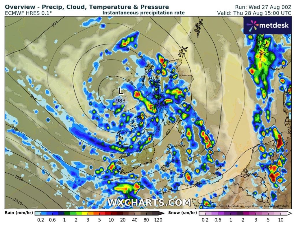
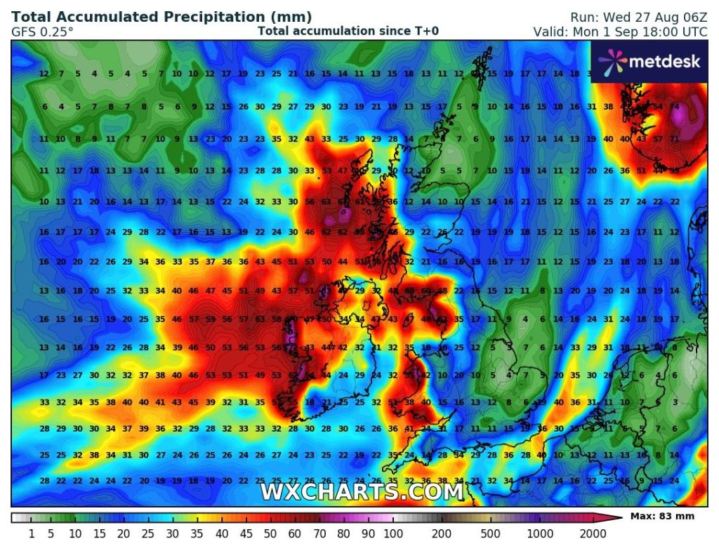
Saturday: It could well start dry but cloud will soon thicken as an area of low pressure brings heavy rain. This could well turn out to be a deep low, and depending on its track, we could well see a warning issued and perhaps a named-storm. This rain will turn showery later as the low pushes away. A disappointing afternoon looks likely. Max 17°C Min 11°C Max Gusts 40mph

Another low pressure to bring a wet Saturday afternoon.
Named-storm potential for the weekend? Doubtful but you never know.

Sunday: Bright spells and showers. Not as many showers as they become more confined to the west. Still windy. Max 17°C Min 10°C Max Gusts 25mph

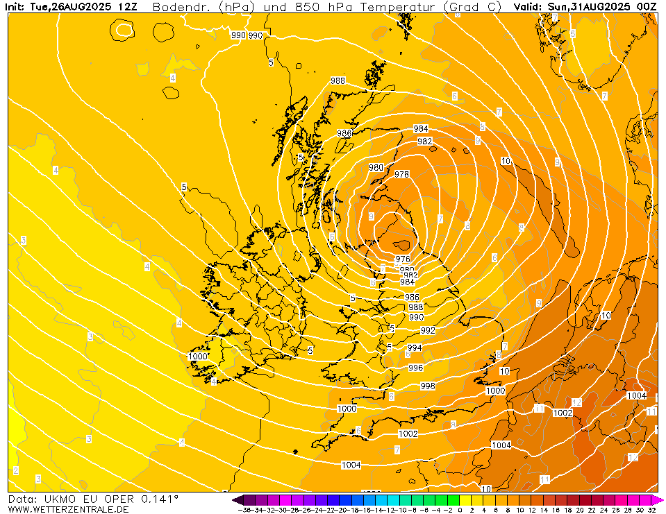
Outlook: The Jet Stream will remain in charge of our weather for the majority of next week. So we will see further unsettled conditions. Bands of showers or longer spells of rain with bright or sunny spells in between low pressure systems. Just a hint towards the end of the week of us returning to a more settled pattern with temperatures around or just above average.

Low pressure dominates for the foreseeable.
After plenty of dry conditions, rain is on the way with western parts of the UK in for a soaking over the next 5 days.

Follow @ChadWeather on X and Bluesky for the latest forecasts and warnings.

Thanks,

Jon

Forecast Issued: Wednesday the 27th of August 2025 at 2:20pm.

Images: http://www.wxcharts.com & http://www.weatherzentral.de

High pressure hangs on, blocking the Atlantic but cloud amounts frustrating at times. Rain to return by midweek? – Thursday 21st August 2025 – Bank Holiday Monday 25th August 2025

Hi all,

Ex-hurricane Erin could well kick-start the Jet Stream next week but lots of uncertainty at this stage. Meanwhile, high pressure will influence the weather for the foreseeable but with the location of the high, this will mean that we will still drag in some cloud which can be frustrating and also hard to predict when we will have breaks in the cloud, to feel some warm sunshine, just like recent days.

We are still well below-average in terms of rainfall amounts. The months following January have all been short of the average and we certainly need rain and it looks like it favours to turn unsettled after midweek next week.

A lot of uncertainty where ex-hurricane Erin will track next week. Where it tracks will have a factor on what weather we will see, but it should help the Jet Stream get back into gear.

Thursday: A cooler start than recently with some clear spells but again cloud is expected to increase, if it hasn’t already, leading to a dry day with limited brightness. Max 18°C Min 10°C Max Gusts 25mph

Friday: Winds should be a little bit lighter and again another dry day with bright spells. Some areas seeing more sunshine than others but difficult to predict where the clouds will break. Max 19°C Min 13°C

Long Weekend: Warmer.

Saturday: Very little change compared to Friday, as in variable cloud amounts and with winds generally lighter. If you are stuck under some cloud it could take some while before blue skies appear. It will be slightly warmer though and if you do see some sunshine it will feel pleasant. Max 20°C Min 12°C

Sunday and Bank Holiday Monday: With summer coming to an end soon, meteorologically-speaking of course,  this long weekend does look like an ideal time to have a BBQ and I would suggest that Sunday or Monday, would be the day as it is expected to be quite warm with more in the way of sunny spells developing helped by the wind switching to a southeasterly. Max 21-23°C Min 14°C

Outlook: Initially it looked like unsettled weather was going to arrive to our shores early next week, but now it looks like it will be delayed until Wednesday or Thursday. Leading up to these days it is expected that we will not see any rainfall. After that, the Atlantic will have more of an influence on our weather. So at this stage Tuesday and Wednesday look dry with bright or sunny spells. But we looked to the west for our weather for the second half of the week and I wouldn’t be surprised to see bands of showery rain arriving.

The next 5-7 days looks dry before change arrives.

Overall it’s been a decent summer, but as I said, some rain would be welcome and it is also long overdue for our weather to turn unsettled.

Follow @ChadWeather on X and Bluesky for the latest forecast and warnings.

Thanks as always for reading.

Thanks,

Jon

Forecast Issued: Wednesday the 20th of August 2025 at 7:45pm.

Images: http://www.wxcharts.com