Relief. Drier and slowly colder as we head into the Christmas Period – Thursday 18th December 2025 – Sunday 21st December 2025

Hi all,

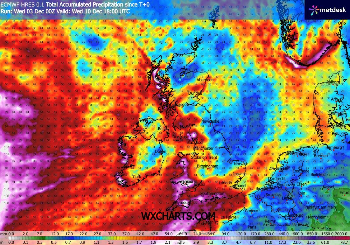
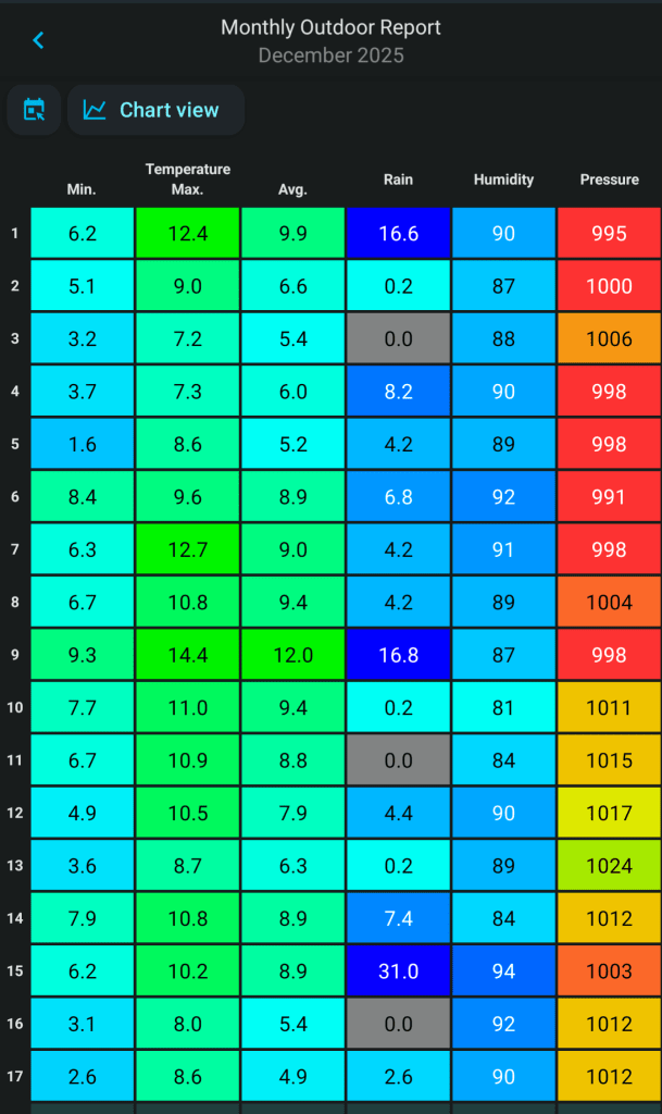
What a terrible month it’s been so far. We’re used to mild and wet Decembers and 2025 is no break from the norm. We’ve had a handful of dry days and just over 100mm of rain. Half the month so far has seen a maximum temperatures of 10°C or above and a few ground-frosts.

December’s stats so far

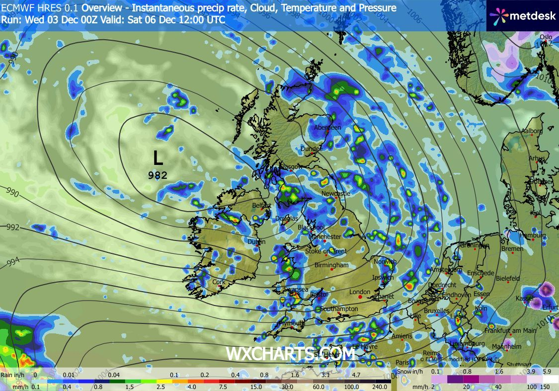
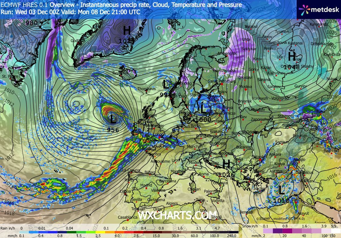
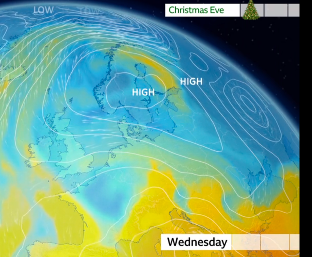
A plunge of cold air in the US has produced a stark temperature contrast which has helped the Jet Stream fire-up weather systems across the Atlantic to the UK. This has brought wind and rain via a conveyor-belt of low pressures. However, this west or southwesterly airflow looks set to be broken as we head towards Christmas with hints of colder air developing. Nothing too significant yet but with an easterly wind you never know what could follow. But, before we commence changing the weather pattern, we will see more rain and wind with mild temperatures.

Thursday: A dry start but cloud thickening and rain heavy at times will spread up from the southwest. Breezy but not that windy. Reasonably mild for the time of year. Max 10°C Min 4°C Max Gusts 20mph

Friday: A better day. Windy with bright or sunny spells and just the odd shower possible. Max 9°C Min 5°C Max Gusts 30mph

Weekend: A change to more of an easterly influence.

Saturday: Sunny or bright spells for the morning and then the wind increasing as rain tries its best to push in from the west decaying all of the time. A keen southeasterly wind developing. Max 9°C Min 5°C Max Gusts 25mph

Sunday: Any rain should begin to ease away but it will remain overcast with a steady but notably chillier breeze. Max 8°C Min 5°C Max Gusts 20mph

Outlook: High pressure is going to build across Eastern Europe meaning temperatures will start to return to the December average. Plenty of cloud is expected at this stage which could be thick enough for pockets of drizzle. Not cold enough for snow and as we head towards Christmas Day the clouds should begin to break slightly. So the big day is set to be dry with a few bright spells but cold especially in the wind which will continue to be from the East. Variable amounts of cloud cover will mean some nights will be frost-free but the odd one could see pockets of frost developing.

Colder air slipping in from the east next week. Image: BBC Weather

Thanks as always for reading. Follow @ChadWeather on X and Bluesky for the latest forecasts and warnings.

Thanks,

Jon

Forecast Issued: Wednesday the 17th of December 2025 at 6:10pm

Images: BBC Weather, http://www.wxcharts.com.

Yet more rain to come and no sign of significant cold or snow – Thursday 4th December 2025 – Sunday 7th December 2025

Hi all,

Winter is here and December has started as November ended, with plenty of rainfall. We only had 8 days without measurable rain in November and 169mm of rain. This is the second wettest November I have recorded since records begin in 2012. The wettest being 2015.

There are a lot of clickbait, attention-seeking posts everywhere about copious amounts of snow coming and bitter-cold. Utter nonsense. It’s always around at this time of year but this year it is worse than ever as local media search for clicks and likes.

Don’t be fooled by the media headlines about cold weather. Image from the Met Office in their post where they dismiss the claims of wintry weather.

Thursday: Rain from overnight will continue early on with some heavy bursts. It will clear eastwards slowly but we should see it drier into the afternoon with perhaps some brightness before dark. Cool and windy at first. Clear skies overnight leading to some patchy ice and a local ground-frost. Max 8°C Min 1°C Max Gusts 25mph

Friday: A chilly start with some patchy frost and fog. Dry with sunny spells for most for the morning but cloudier into the afternoon with more rain arriving in time for the evening. Feeling cold, especially later on and into the evening as winds strengthen from the south-east, possibly gale-force at times. Max 8°C Min 5°C Max Gusts 45mph

Weekend: Low pressure in charge.

Saturday: Showery rain will be coming and going but winds do look lighter than late on Friday. Slightly milder too but it’s the overcast, dull and dank conditions that are so depressing. Max 11°C Min 7°C Max Gusts 20mph

Low pressure controlling the weather on Saturday

Sunday: A few showers around for the morning but these should ease away for a time with some brightness. Cloud thickening once again ahead of rain forecast for the afternoon and evening. Some uncertainty on the timing and position of this rain-band so look out for forecasts on social media. Max 11°C Min 4°C Max Gusts 25mph

Outlook: It looks like an unsettled week I’m afraid. Plenty of low pressure systems, bringing wind and rain at times. Some drier spells in between. No sign of any high pressure yet, to settle things down and bring some frosty days back. No snow/significant cold expected. Lets hope we’re saving all the snow for Christmas Day.

Low pressure queuing up to steam across the Atlantic in the coming days/next week
Yet more rain awaits – most places seeing 25mm over the coming week with some areas seeing up to 50mm (2 inches)

Follow @ChadWeather on X and Bluesky for the latest forecasts and warnings.

Thanks,
Jon

Forecast Issued: Wednesday the 3rd of December 2025 at 5:34pm.

Images: The Met Office & http://www.wxcharts.com.