This is a weekly blog with a 4-day weather forecast (THU-SUN) for Manchester, and its surrounding areas.
Weather statistics from the dedicated Vantage Pro 2 weather station in Chadderton, Oldham. Live statistics are updated every 1 minute here, https://www.wunderground.com/personal-weather-station/dashboard?ID=IOLDHAMC2.
Follow me on Twitter, @ChadWeather and follow the statistics account, which updates hourly at @OldhamWXStats.
After a few days with patchy rain and some showers, the week ahead continues in a similar theme with no heatwave returning just yet. Best day of the weekend looks like Saturday.
There are signs of something more unsettled early next week then hopefully after that summer-like conditions return.
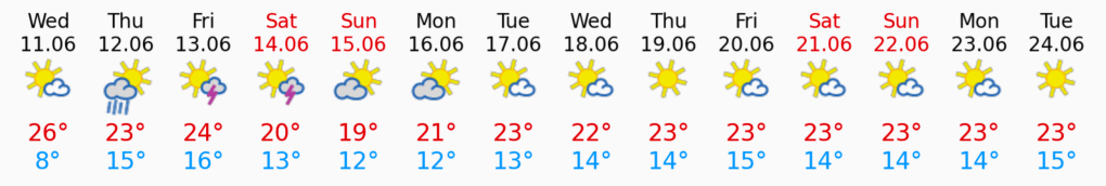
Thursday: Mostly cloudy to start, with a few showers in the south and west. These will move away quickly and then it will be a day of bright spells and a few scattered showers with more in the way of sunshine later in the day. Quite a keen northwesterly breeze. Max 20°C Min 12°C Max Gusts 25mph
Friday: Bright or sunny spells and the odd shower. A north to northwesterly airflow so not as muggy. Max 19°C Min 12°C Max Gusts 25mph
Fresher air on Friday.
Weekend: Sunnier on Saturday.
Saturday: Mostly dry with plenty of sunny spells developing. Again, a fresh breeze and still the low chance of an isolated shower early on. Max 20°C Min 13°C Max Gusts 20mph
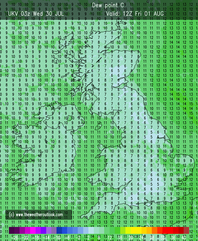
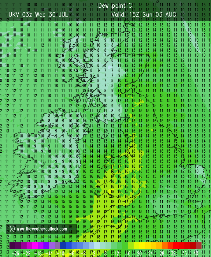
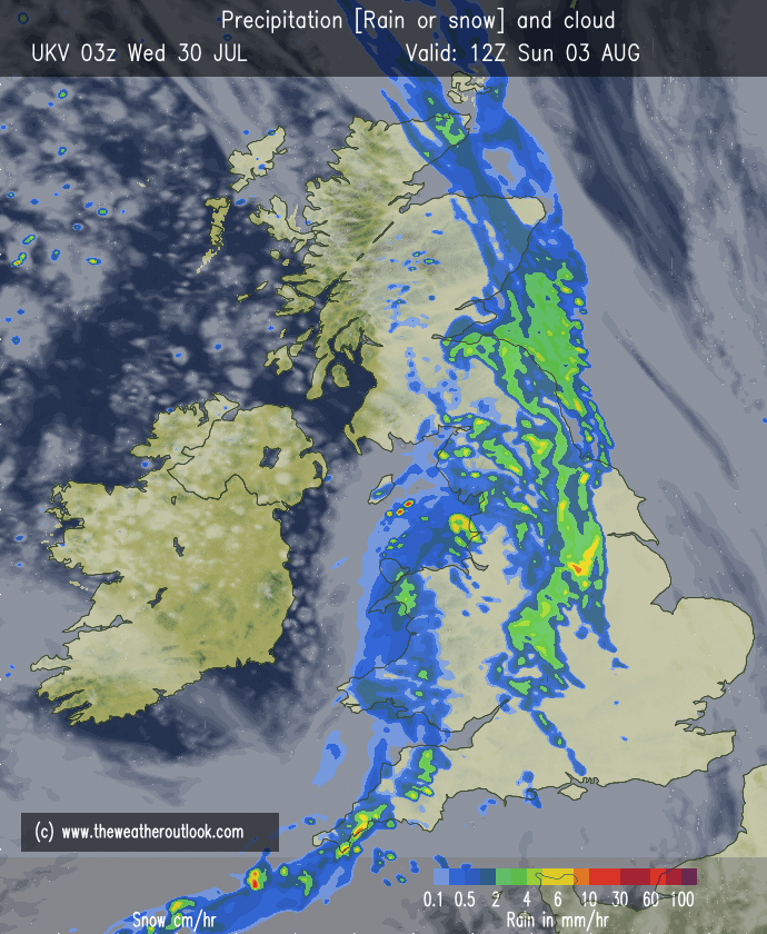
Sunday: Any bright spells soon fading as cloud thickens from the northwest bringing a spell of rain, some heavy which will turn patchy after midday. Feeling more humid once again. Max 20°C Min 13°C Max Gusts 15mph
Muggy again with rain on Sunday.
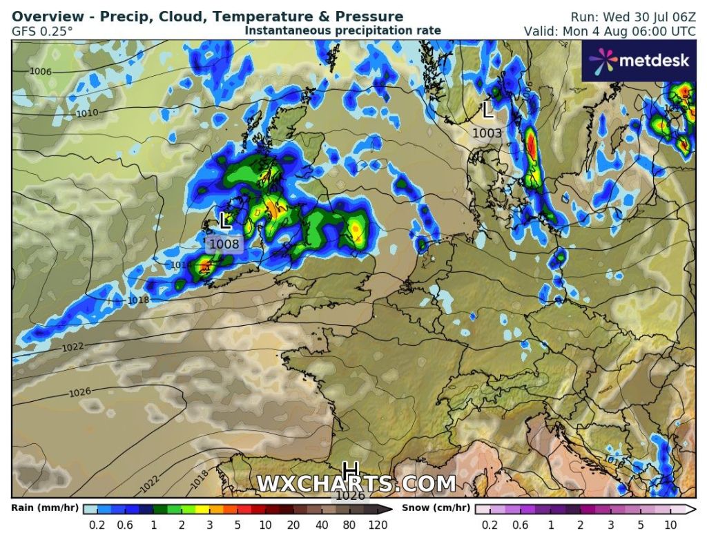
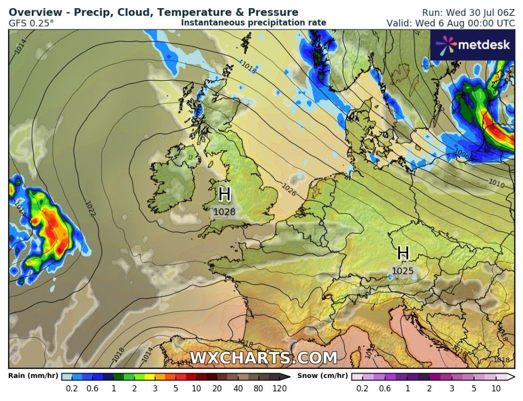
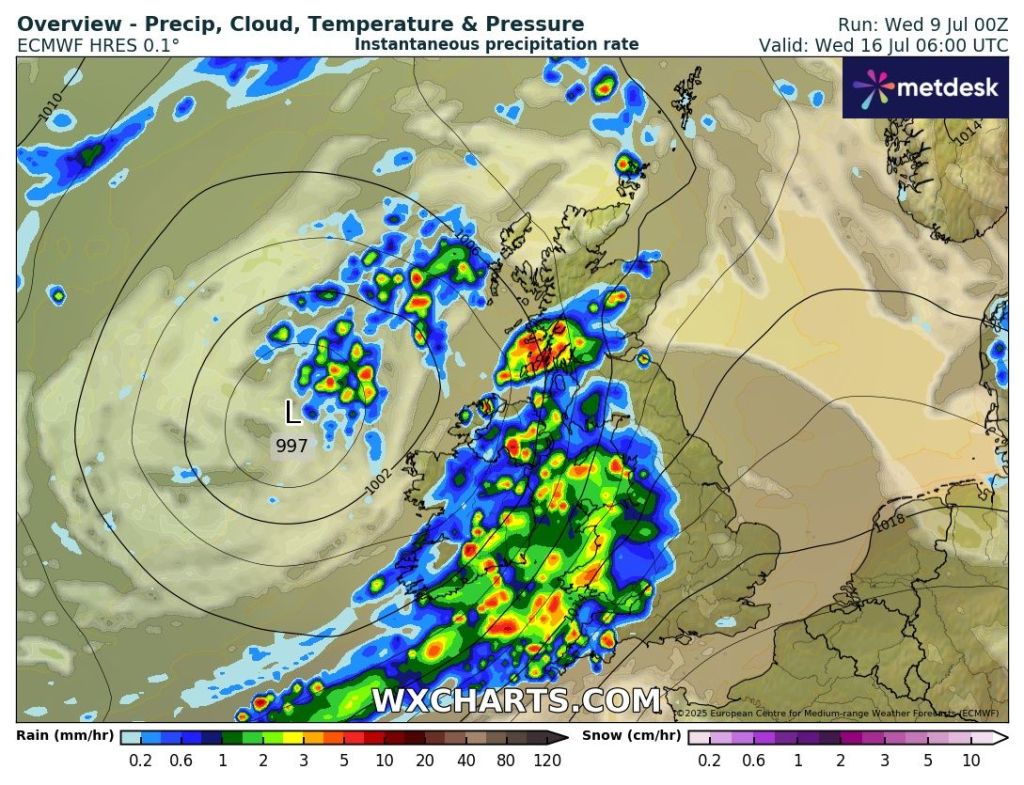
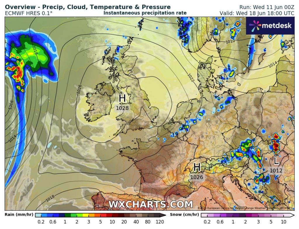
Outlook: At this stage Monday and into Tuesday looks unsettled with details uncertain. After that high pressure should build in bringing warmer sunnier days but how long it lasts is the question.
For a few days now, there have been hints at quite an active low pressure system for Monday and Tuesday. Different computer models suggest different scenarios and this is still the case. So look out for updates on X and Bluesky. High pressure to arrive in just under a week’s time?
Thanks for reading as always.
Follow @ChadWeather on X and Bluesky for updates and warnings.
Cheers, Jon
Forecast Issued: Wednesday the 30th of July 2025 at 6:50pm
No sunny heatwave over the coming days but temperatures will be into the early-20s but as well as feeling muggy there will be some rain in the mix too.
After an unsettled spell, I’m hopeful (but it’s now looking increasingly unlikely) that an area of high pressure will be close by to keep our weather a bit more settled into next week with temperatures expected to return to normal.
Tuesday was a very wet day compared to recent times with 17.8mm falling at Chadderton HQ making it the wettest day since January the 5th. Just what the gardens needed after months of below-average rainfall.
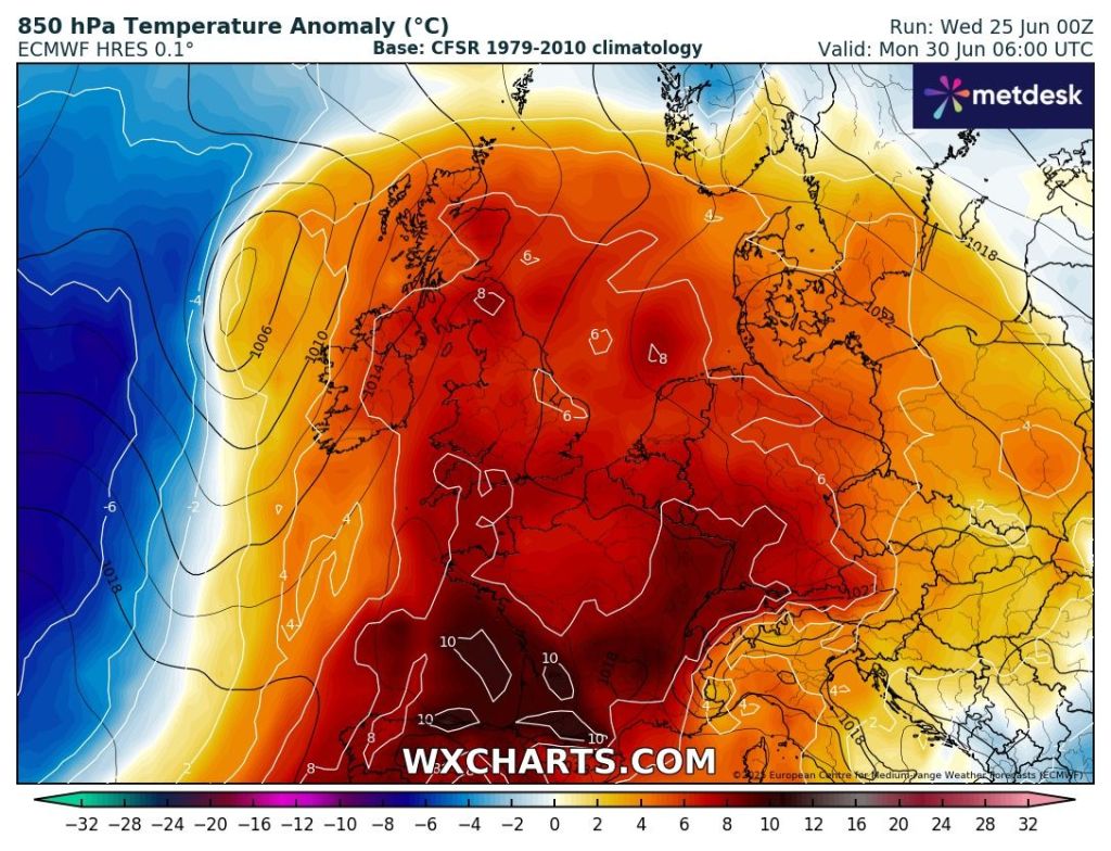
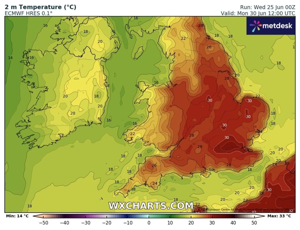
Warm and muggy again with some parts of the region seeing temperatures close to 25°C over the next couple of days and with 30°C returning to the SE.
Thursday: Humid on Thursday and a cloudy morning as a weakening band of rain and drizzle moves through. Into the afternoon it will slowly become brighter and the sunshine could set off a few localised hefty showers. Warm overnight. Max 22°C Min 15°C
Friday: Very warm with sunny spells but also the chance of an isolated shower, especially during the morning. Another muggy one. Max 24°C Min 16°C
Weekend:Feeling close and wet at times.
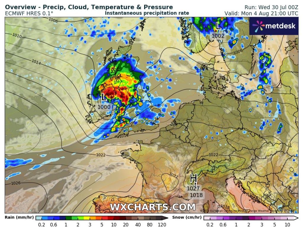
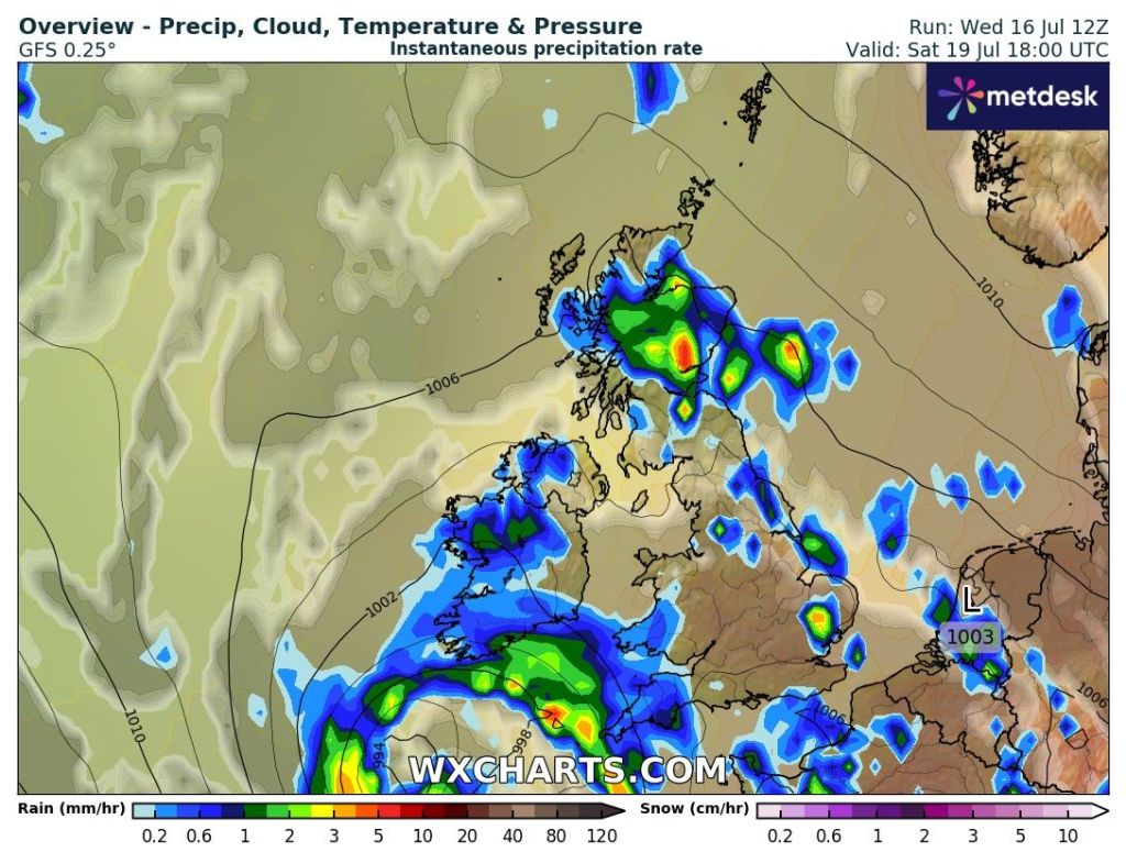
Saturday: Some uncertainty for Saturday’s forecast. At this stage we could see an area of low pressure drift up from the south. It will be a warm day but after any brightness during the morning cloud will thicken and rain or thundery showers will spread up from the south. Max 23°C Min 15°C
Uncertainty for Saturday afternoon as some models suggest heavy thundery rain from an area of low pressure yet some suggest the rain to be more showery in nature.
Sunday: A day of bright spells and showers which could be thundery and increase in frequency later in the day. Still warm especially overnight. Max 23°C Min 15°C
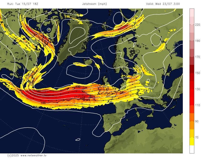
Outlook: It did look like an area of high pressure will ridge in from the southwest as the week progresses, but now it looks like it could remain unsettled as the high can’t push in and the jet stream brings in occasional showery rain from the west. Hard to pin down any details at this stage.
Jet Stream in control next week?
Thanks for reading as always.
Follow @ChadWeather on X and Bluesky for the latest forecasts and warnings.
Thanks,
Jon
Forecast Issued: Wednesday the 16th of July 2025 at 6:30pm.
Personally, I’m not a fan once temperatures start to get into the mid-20s or beyond. Obviously I’m talking about this country where heat is usually accompanied by high dew points leading to humid conditions and uncomfortable nights trying to get to sleep.
I’ll be keeping an eye on the dew points and the humidity over the course of the heatwave, as it’s likely that the first couple of days will not be as muggy as you would expect. As the temperature rises day-on-day and the nights become warmer and the heatwave starts to reach its latter stage, it is likely that the humidity and dew point values will rise which some people will find unpleasant.
If you love a heatwave and hot conditions with plenty of sunny spells, then this forecast is for you.
My poll on X suggests it’s a split of love it or loathe it
Thursday: A heatwave is not declared until we have three consecutive days of 25°C or above. So technically the heatwave will not be confirmed until Saturday, but because we are confident that temperatures will exceed the threshold then today is the first day of the heatwave which is expected to last 5 days. Mostly light winds. Very warm sunny spells and not too humid for now. Max 26°C Min 15°C
Friday: Hot and sunny with light and variable winds. Max 30°C Min 17°C
Weekend: A scorcher.
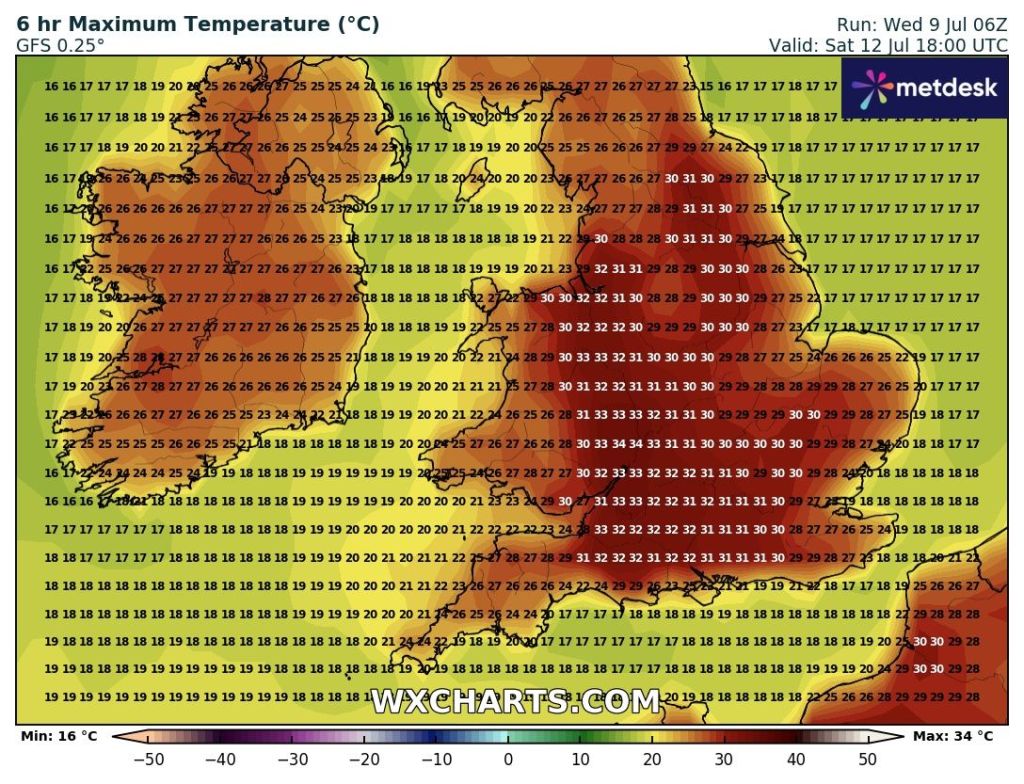
Parts of NW England look set to be one of the hottest parts of the UK during the peak of this heatwave. 31-33°C possible.
Saturday: Another hot or very hot and sunny day. Hopefully a little bit of a breeze into the afternoon. A very low chance of an isolated thunderstorm but it seems highly unlikely. A warm night for sleeping. Starting to become more humid. Max 32°C Min 18°C
Sunday: Rinse and repeat for Sunday. If any difference perhaps the breeze will have picked up a little bit which will bring a bit of relief from a very hot day. Again, a very low risk of a shower on the hills. Fans on full blast for bedtime. Max 31°C Min 19°C
High pressure means dry conditions over the next 4-5 days with little to no rainfallWarm nights to come
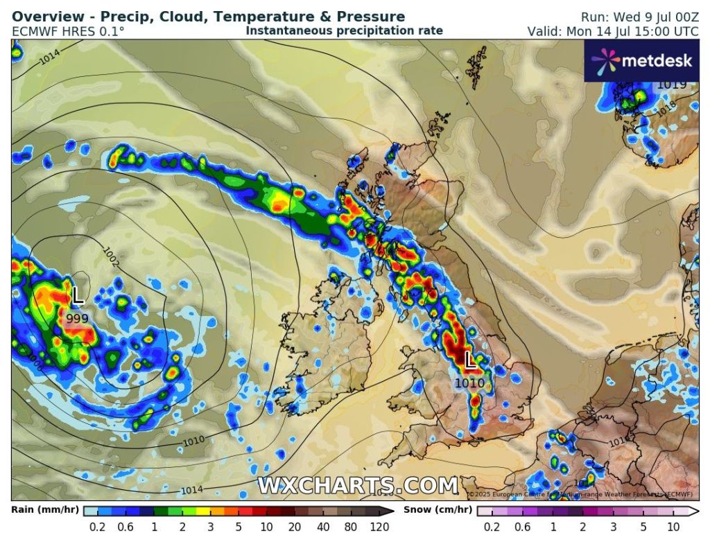
Outlook: The heat could eventually trigger some localised thundery downpours on Monday but this could well be delayed until Tuesday such is the uncertainty at this stage. But what looks certain is that the heatwave threshold will end with cooler temperatures arriving on Tuesday but still humid. After that the week looks warm, early-20s, muggy and with bright spells and heavy thundery showers.
The heatwave could well break with some thundery downpours later on Monday or more likely into Tuesday/Wednesday.
Follow @ChadWeather on X for the latest forecasts and warnings.
Thanks as always for reading.
Jon
Forecast Issued: Wednesday the 9th of July 2025 at 5:30pm.
As mentioned last week we didn’t experience a heatwave across the majority of Northwest England this week. We actually only saw one day exceed 25°C as the majority of the heat plume was reserved for more southern and eastern parts of England.
That said, it’s been uncomfortably muggy and hard to get to sleep at night, even with fans on in the bedroom. Thankfully a cold-front has now brought fresher air from the west and the evenings, for now, will be a bit more pleasant when turning in for the night.
Make the most of the next couple of days as we’ll see plenty of sunshine on offer and more pleasant temperatures but unfortunately the weekend is looking unsettled with low pressure in charge. Also with a lot more moisture in the air, the dew point will increase and again it will become quite humid.
Thursday: Windy at times but plenty of sunny spells. Can’t rule out an isolated shower. Temperatures around average so feeling pleasant in the sunshine, especially without the humidity. Max 20°C Min 11°C Max Gusts 25mph
Friday: A similar day. Plenty of sunny spells, mainly dry, just the outside chance of a shower but the risk is low and another breezy one. Cloud will begin to thicken towards evening and patchy rain will arrive and a more humid airmass will set in overnight. Max 21°C Min 13°CMax Gusts 20mph
Weekend:Rain at times but some drier spells.
Saturday: The morning looks cloudy with patchy rain. In the afternoon we might see a few bright spells develop, as the wind increases breaking the cloud up, but we can still expect some showers. Max 19°C Min 12°C Max Gusts 25mph
Sunday: The second half of the weekend looks like a day of bright spells and showers after a mostly cloudy start. Again, a breezy one and temperatures slightly below average. Max 18°C Min 11°C Max Gusts 20mph
Low pressure to bring some unsettled weather this weekend
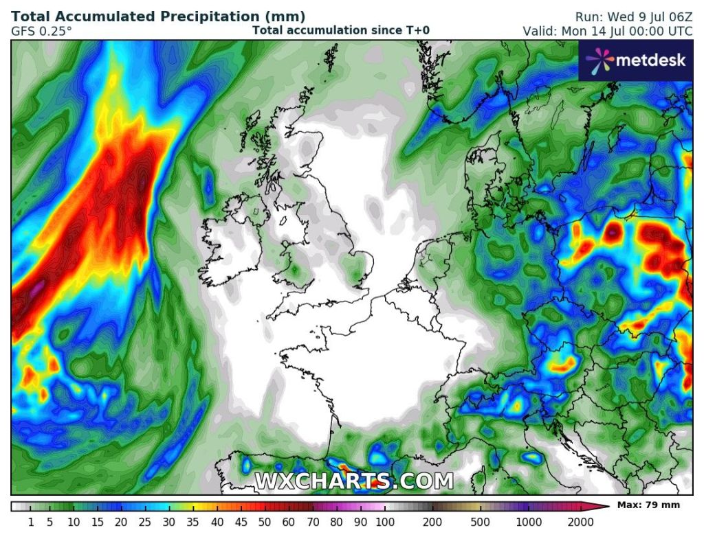
Outlook: Another showery day on Monday and then the following few days seem a bit of a mixed bag. There’ll be high pressure to the southwest of the UK and low pressure or bands of showers to the northwest. We will be sandwiched in between, so we can expect bright spells and equally some showers. Temperatures below average until later in the week when they should return to the early twenties with some welcome sunshine returning in time for the weekend. No sign of another heatwave across our region just yet.
Cooler-than-average early next weekMixed bag next week
Follow @ChadWeather on X and Bluesky for the latest forecasts and warnings.
Thanks,
Jon
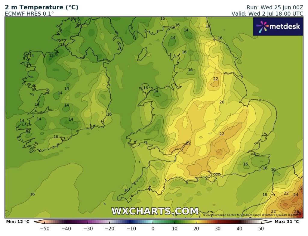
Forecast Issued: Wednesday the 2nd of July 2025 at 2:40pm.
Where is time going? Almost a third of summer done.
So far June has an average temperature of 15.6°C which makes it the joint-second warmest June I’ve recorded with records back to June 2013. June 2023 was the warmest at 17.3°C. This is mostly down to some warm and muggy nights, and we have some more of these to come this week.
Thursday: A band of rain to start which will turn showery towards lunchtime. Generally turning brighter and drier into the afternoon but also fresher and windier. Max 20°C Min 13°C Max Gusts 30mph
Early rain on Thursday
Friday: There will be a new weather-front close by to our northwest on Friday. Parts of the region close to this front could well see some light rain with most places cloudy. Some bright spells in the southeast are possible. Starting to turn quite humid and windy again. Warm night. Max 22°C Min 17°C Max Gusts 25mph
If this rain can be a bit further northwest on Friday we will see more in the way of bright spells
Weekend: The thermometer rises into Sunday.
Saturday: Some early rain should move on quite quickly and then a breezy day with sunny spells and mostly dry conditions. Becoming very warm. Max 24°C Min 16°C Max Gusts 25mph
Sunday: Some stubborn cloud to clear and very warm to hot with sunny spells developing. Not as windy as recently. Max 25°C Min 16°C
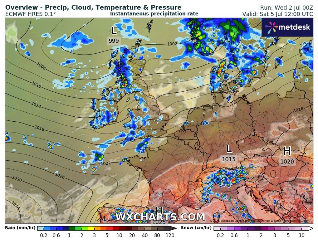
Outlook: Monday will be another hot one with plenty of sunny spells. Fresher air will arrive on Tuesday with a few showers blown in on a northwesterly wind. After that becomes a little bit more uncertain, but a ridge of high pressure nudging up from the Azores is currently the favourable outcome. So we do see some hot weather as we enter next week but it will be short-lived and shouldn’t reach the heatwave threshold.
A short-lived burst of heat on Sunday and Monday with maximum temperatures well above average. Fresher air returns into Tuesday.
Thanks for stopping by to read. Follow @ChadWeather on X or Bluesky for the latest forecasts and warnings.
Thanks,
Jon
Forecast Issued: Wednesday the 25th of June 2025 at 5pm
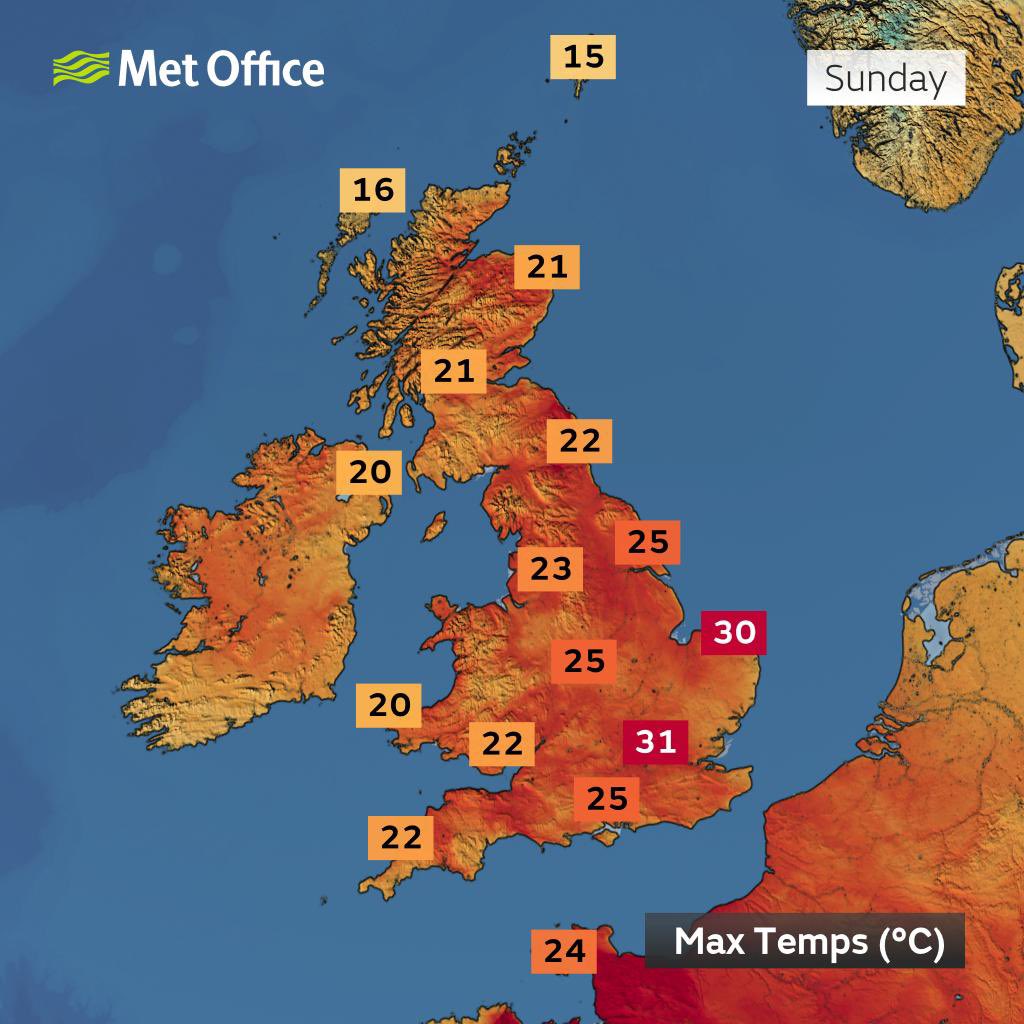
Spring was a belter, very dry and with some really warm days, but summer hasn’t got off to the best of starts. That said, we are about to experience our first heatwave of the season.
There is a certain threshold for it to be classed as a heatwave and no matter how long it lasts, there is no such thing as a “mini-heatwave”.
Met Office Heatwave Threshold
So far this year the warmest temperature I’ve recorded, came in April (30th) with a high of 25.9°C. That will certainly get beaten over the next few days. There’s an outside chance that somewhere could see 30°C. As we head into the weekend there will be a bit of a welcome breeze picking up and eventually cooler air and also the risk of a thunderstorm or two.
Hot days and warm nights ahead but how long will the heatwave last?
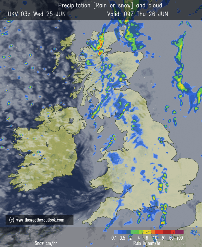
Thursday: A southerly airflow and plenty of hazy sunshine, making it feel toasty from mid-morning onwards as temperatures rocket. With light winds the heat will build and it will be hot into the afternoon. Overnight, expect a warm one but a bit breezier. Max 29°C Min 17°C
Friday: Another hot day but at least a wind will have picked up, helping those who hate the heat. Plenty of sunny spells and there’s a chance that some cloud could bubble up and set off an isolated shower towards evening but the risk is low. An uncomfortable night for sleeping. Max 28°C Min 18°C
💡 Heatwave safety tip: Keep pets cool and drink plenty of fluids with your BBQ 😉.
Temperatures will be well above average later this week as a short-lived heatwave (longer for the SE of the UK) occurs across the region.
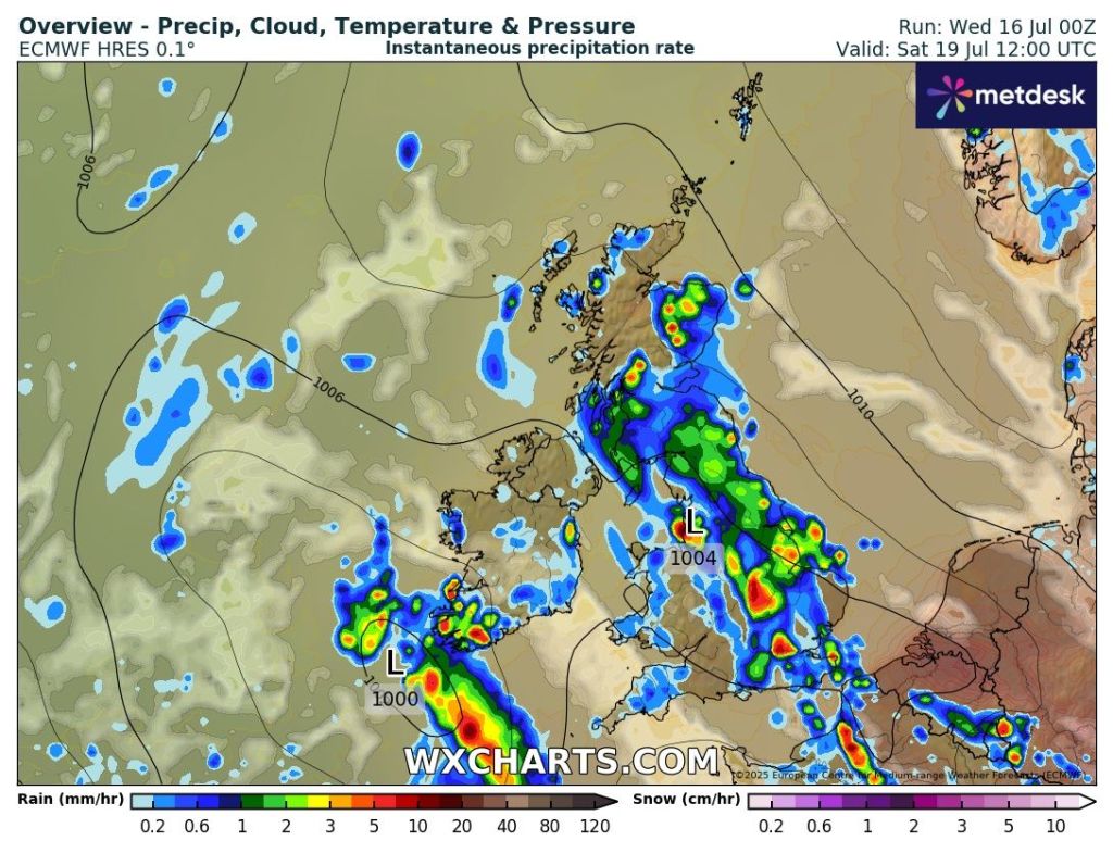
Weekend: Change into Sunday. Thunderstorms possible.
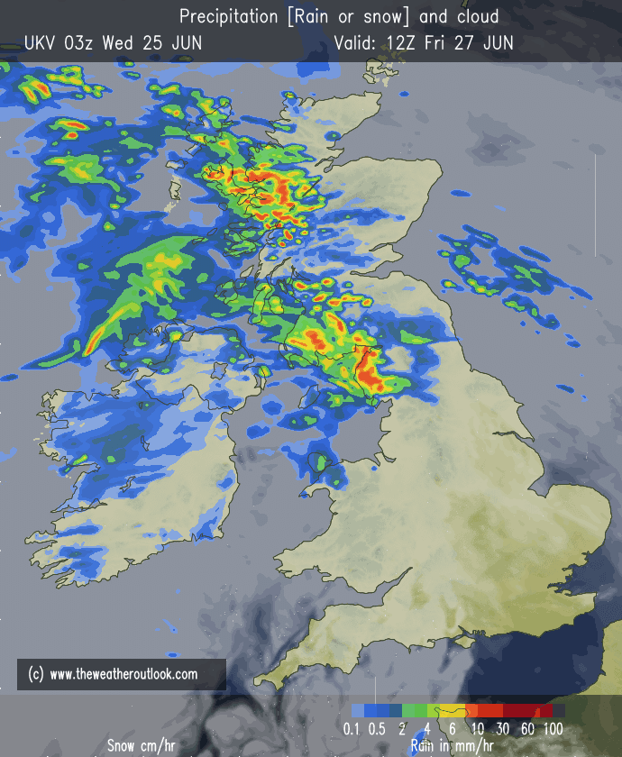
Saturday: Starting to feel more humid and after a morning of sunny spells, cloud is expected to bubble up and there will be a few scattered thundery downpours into the afternoon/evening and also overnight. Again it will be breezy and a switch to a westerly wind later into the night. Max 29°C Min 16°C
Thunderstorms possible before a cool down into Sunday
Sunday: Winds are now expected from a westerly direction, so this will have an impact on the temperature knocking it back down several degrees. Another reasonable day ahead with sunny spells but it will be breezy and there is a slight chance of an afternoon or evening shower which could be thundery. Max 23°C Min 15°C
The heat is pushed away to the SE on Sunday as winds turn westerly. Image: BBC Weather
Outlook: A mixed bag into next week with bright spells and a few showers. Temperatures returning to 19-20°C for a few days and then becoming a little bit warmer towards the end of the week and hopefully high pressure will build again. But at this stage what pans out after midweek next week is uncertain. So stay tuned to my social media accounts for updates.
Follow @ChadWeather on X and Bluesky for the latest forecasts and warnings.
Thanks,
Jon
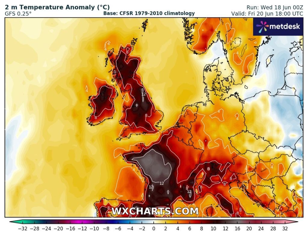
Forecast Issued: Wednesday the 18th of June 2025 at 6:16pm.
My weekly blog is back after a few weeks off and a cracking holiday in Zante and whilst I was away it pretty much rained every day back home and the very dry conditions have eased with more rain in the last 2-3 weeks than there has been in the previous few months.
Today, Wednesday, we have picked up a southeasterly feed which is dragging in much warmer and humid air. You will have noticed that it’s turned out on Wednesday to be a very warm day but the question is how long are these conditions set to last?
It’s going to remain humid for a couple of days, but we aren’t going to be seeing wall-to-wall sunshine. Weather-fronts will be moving in from the west and the southwest during Thursday and Friday so we are expecting some rain which could be thundery at times. It’ll be fresher by the weekend.
Thursday: It’ll be a warm and humid start with some sunny spells, but cloud will soon increase from the southwest. As we head towards the afternoon, a band of thundery rain is expected to arrive lasting a few hours and it will turn windy. Later in the day and heading towards late-evening it should become drier but it’ll still remain muggy leading to a uncomfortable night for sleeping. Max 23°C Min 15°CMax Gusts 30mph
Thundery rain later on Thursday.
Friday: Friday will be another humid day with some sunny spells, but cloud will bubble up later into the afternoon and there will be some isolated thundery showers breaking out which will be hit-and-miss. Once these move through, especially overnight away to the north of the region, slightly fresher air will arrive behind them. Max 24°C Min 12°CMax Gusts 25mph
Weekend: Not too bad at all.
Saturday: Sunny spells after any overnight rain pushes away to the north. I can’t rule out a dry day with a few showers breaking out into the afternoon, again these could be thunderstorms. Otherwise not too bad and feeling fresher. Windy at times. Max 20°C Min 10°CMax Gusts 25mph
Sunday: It looks like a decent day with conditions perfect as the humidity has now moved on. Sunny spells, dry and a little bit windy. Max 19°C Min 10°CMax Gusts 25mph
Outlook: As we head into next week, high pressure will initially ridge up from the Azores but for the first few days we will get some cloud coming round the high pressure from the northwest, but is it expected to stay mostly dry. Later in the week the high pressure will centre itself across the UK and we can expect the week to be dry with plenty of sunny spells and because of the wind direction, temperatures are expected to be around normal with no heatwave or high humidity expected. Beyond this is uncertain so make the most of next week and enjoy some pleasant temperatures.
High pressure centred over the UK next Wednesday. A mostly dry outlook after this weekend.
Follow @ChadWeather on X or Bluesky for the latest forecasts and warnings.
Thanks,
Jon
Forecast issued on Wednesday 11th of June 2025 at 6:50pm.
The “rainless” May goes on here. Yes I know we had some rainfall early one morning but it didn’t register, so the total for May still stands at 0mm.
Rainless May
We (UK) are on course for the driest and sunniest spring ever recorded. It’s simply been an incredible season but places are getting desperate for rain now.
The local reservoir levels are at 56% compared to 83% this time last year.
So when will it rain? Not for at least another week. There are signs however of low pressure replacing high pressure as we head towards the Bank Holiday weekend, typical, but it still remains to be seen if the low will be strong enough to oust the stubborn high.
Before that, plenty more of the same. Sunny skies, warm, dry and breezy at times.No sign of a heatwave for now, as the positioning of the high means we won’t be tapping into any hot air from the south.
UV levels are now HIGH 11AM TO 2PM.
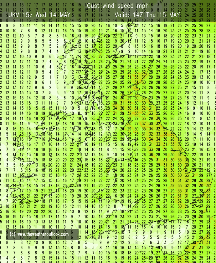
Thursday: Similar to Wednesday, there is a chance that we start the day with some low-cloud that has drifted in from the northeast. This will be a little stubborn to clear but it will burn off leading to another glorious day with plenty of sunshine. Winds a little gusty. Warmest in the west. Cool overnight where winds fall lighter. Max 18-20°C Min 5°CMax Gusts 25mph
Some breezy days ahead
Friday: Temperatures rising a touch. Still windy though, more so into the afternoon. Dry and sunny. Max 22°C Min 7°CMax Gusts 25mph
Weekend: If you’ve not had a BBQ yet then what are you waiting for? Little change.
Saturday& Sunday: Might as well group these days together as they will be very similar. Plenty of sunshine, most likely wall-to-wall sunshine. Dry and again a breezy northeasterly. Max 22°C Min 8°CMax Gusts 20mph
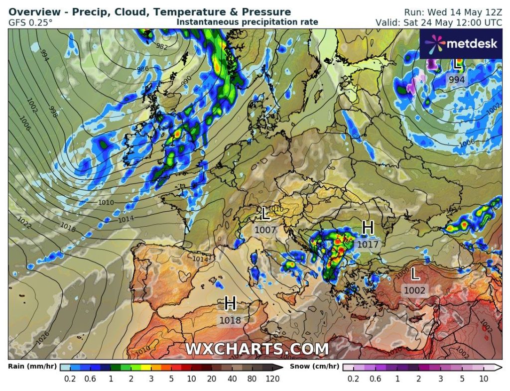
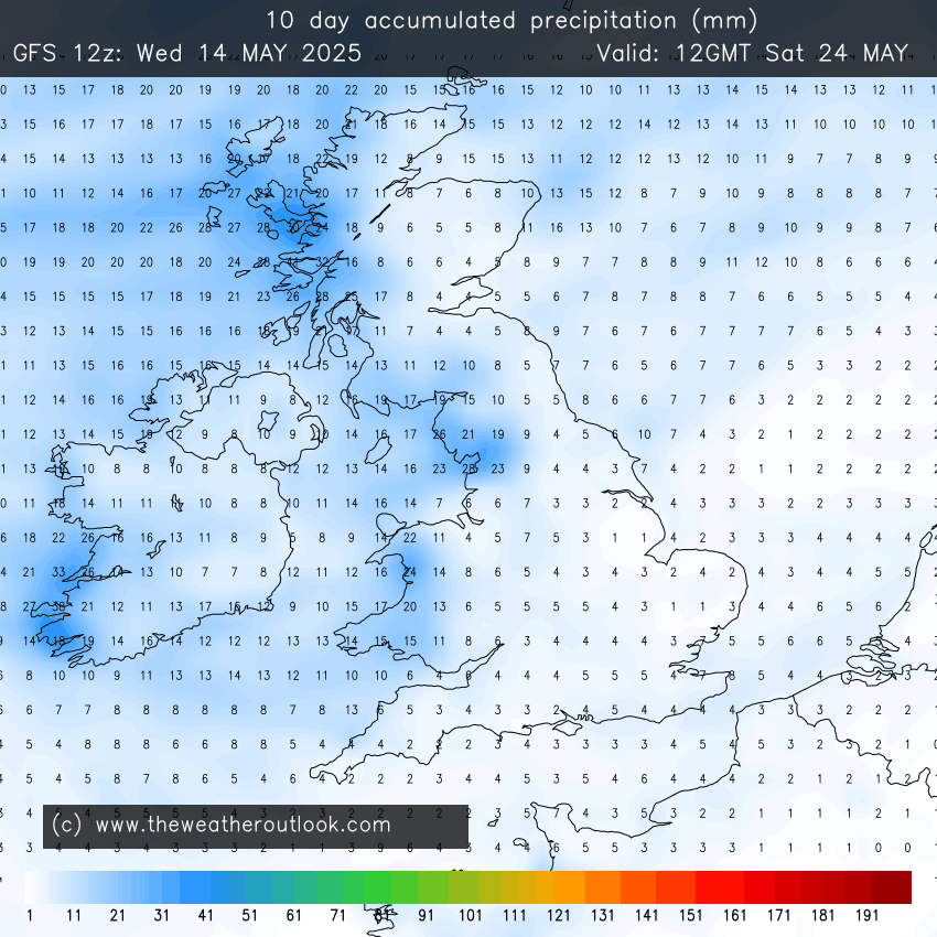
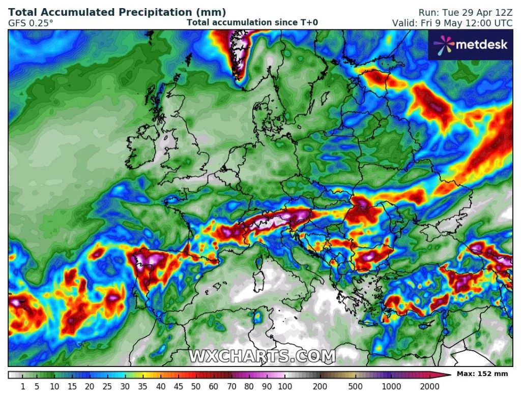
Outlook: It’s quite a simple outlook for most of the week as high pressure continues to stay in charge, bringing sunny skies and dry conditions. Temperatures sitting around 20°C. It’s later in the week, where the forecast gets a little bit tricky from this far out, but there are signs, which I’ve been hinting at for a few days now, that high pressure will slip away and low pressure will start to bring weather-fronts in from the west. We will finally see some rain and this could mean the final week of May brings unsettled conditions. One to watch for now and look out for updates on social media. The petrichor smell will be epic.
Changes around the 24th?The 10-day total precipitation forecast shows rain amounts increasing from the west
Follow @ChadWeather on X and Bluesky for the latest forecasts and warnings.
Thanks,
Jon
Forecast Issued: Wednesday the 14th of May 2025 at 7:20pm.
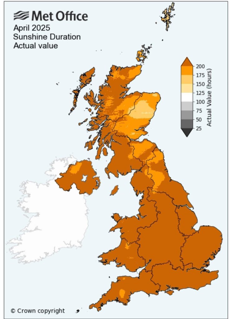
It’s turning out to be an amazing Spring with plenty of settled weather, also meaning it’s been very dry. It’s no surprise that we’ve had the sunniest March and April on record across the UK.
Sunshine stats from the Met Office for April
I’ve said it for a few weeks now. We need some rain. We are well below-average for Spring, sitting at 23% of the average rainfall, And yet again there is no sign of any significant rainfall amounts over the next 2 weeks.
High pressure, that has been in control of our weather this week, has been in a position to bring some cloud in from the North Sea, making it cooler at times. This cloud moves around the high so sunny spells have been coming and going.
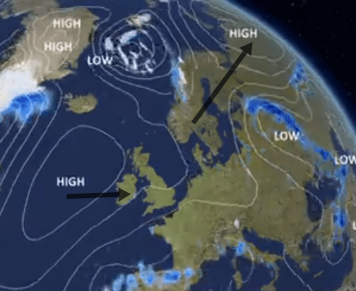
Towards the end of the week, this high will slip away to the northeast and introduce a drier and warmer south-to-southeasterly airflow. Temperatures will respond. This will then be replaced by another high pressure that will slip in from the west as we head into next week bringing further dry weather and pleasant sunny spells.
Next week our high will slip away but in the back door comes another. Image: BBC Weather
It was a cold start to Tuesday this week, with a ground frost in many places and some places recording an air frost but this is not unusual for early-May, especially under the influence of high pressure, clear skies and light winds. A couple of chilly nights to come this week but from Friday the risk, for frost, for now has passed.
Thursday: Still variable amounts of cloud throughout the day so sunny spells one minute and then thicker cloud the next. Dry and with that high pressure starting to slip away there will be a keen breeze. Warmest in sheltered western parts. Max 18°C Min 5°C
Friday: Feeling much warmer with more in the way of sunshine and lighter winds. Very pleasant indeed. Max 20°C Min 6°C
Don’t forget your sun cream if you’re out and about in the sun for a lengthy period of time. UV levels are now up to HIGH around lunchtime and MEDIUM for most of the morning and the afternoon.
Weekend: Decent. One hand on the BBQ, one hand watering the garden .
Saturday: Some early mist and another great day, warm with sunny spells. Max 22°C Min 7°C
Sunday: With southerly winds in place and plenty of sunshine temperatures will lift and it will really feel like summer again. Some cloud could well bubble up enough later in the day/evening to produce an isolated shower or thunderstorm as the air gets a little bit of instability from a low pressure to the south of the UK. Max 22°C Min 9°C
Warmer this weekend but rain/showers will cool off the SW of the UK.
Outlook: There is an outside chance, later on Sunday and into Monday, of an isolated shower. Otherwise, the week will be dominated again by high pressure slipping in from the west, bringing plenty of sunshine and temperatures close or into the 20s °C. With us only having a quarter of our rainfall during March and April, we will now be 2 weeks into May without any significant rain.
Some instability, coupled with the warmth, could trigger some downpours on Sunday PM into Monday. One to watch for now.
If this continues, we could well start to hear the words drought or hosepipe ban mentioned in the news. It’s got to change at some point and I’m not complaining about the lovely weather, but we are definitely in need of some rain.
Thanks for stopping by to read. For more forecasts and warnings please follow @ChadWeather on X and Bluesky.
Thanks,
Jon
Forecast Issued: Wednesday the 7th of May 2025 at 6:06pm.
We’ve had more decent weather this week. It really has been a good spring so far and very dry. We are well-below average rainfall since the start of February.
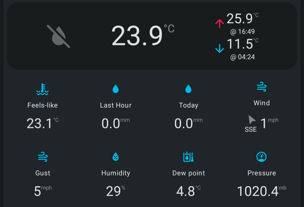
The last day of April saw my warmest April day on record. My data goes back to 2013. The max was 25.9°C recorded at 4:49pm.
A hot end to April with a record-breaking maximum.
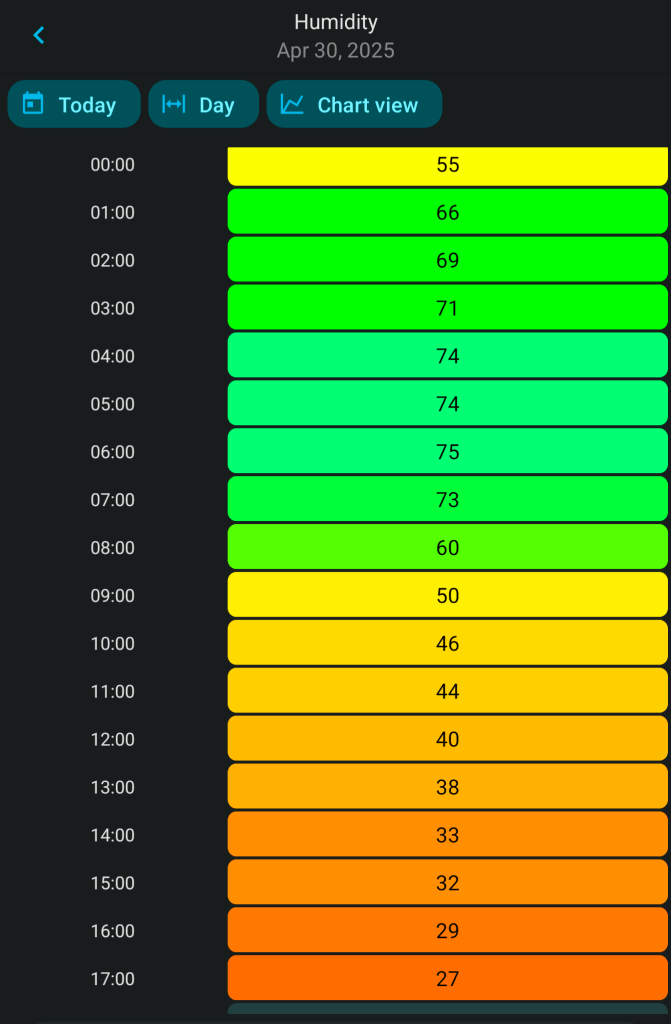
Humidity levels have been low too. Perfect drying weather.
30th April – humidity values hour-by-hour.
For the NW of England it’s been the driest Feb-Apr period since 1938. Thanks to @kevirlam on X for this stat.
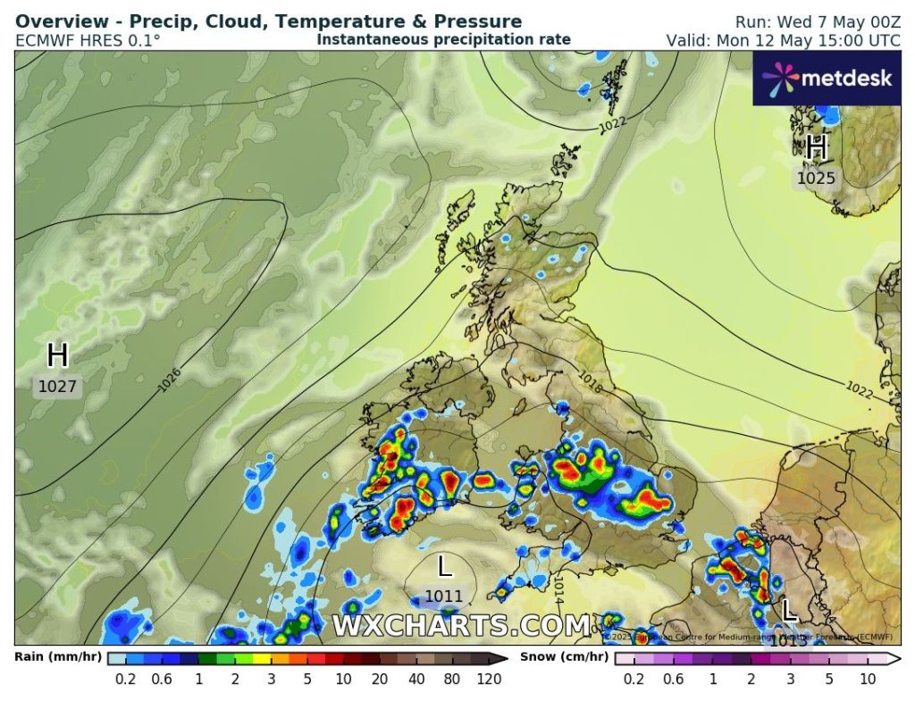
Not much rainfall is expected over the next week or so. It is getting to the stage where we need some rain.
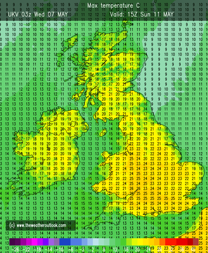
Thursday: Hot, with sunny spells and feeling more humid. It will be the last summer-like temperatures of this week as temperatures will cool off as a weakening cold-front comes down from the northwest. There will also be another weather-front to the south of the UK. So, the air will be a little bit more unstable on Thursday and with the heat there is just a chance (15%) that we see some isolated showers breaking out which could be locally heavy and thundery. Currently this is more likely to happen to the south of our region. Max 26°C Min 8°C
Friday: It looks like we’ll be in the middle of decaying weather-fronts, so a dry day is expected with plenty of sunny spells. Cooler than recently which some of you will be thankful for and dry. Cool overnight. Max 20°C Min 6°C
Long Weekend: Question marks overthe bank holiday.
Saturday: Looks like a decent day with bright spells, dry and light winds. Temperatures still above average so feeling pleasant out there but a cool wind developing later. Cold night. Max 19°C Min 4°C
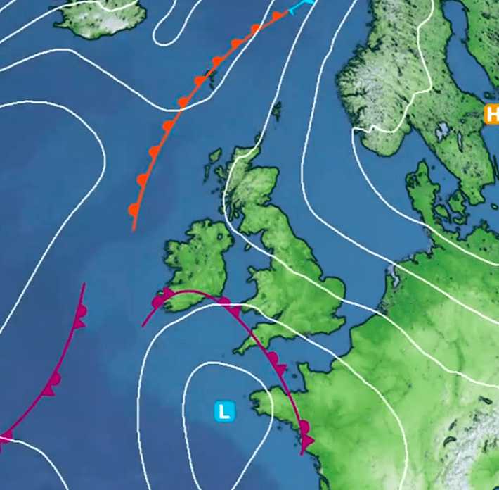
Sunday: Some uncertainty but it looks like a pool of colder air will drift in from the north/northeast with some thicker cloud making it feel chilly. Western areas could well hang on to some sunshine and temperatures warmer here. Winds will be gusty. Max 12-16°C Min 5°CMax Gusts 25mph
Cooler air arrives on Sunday with temperatures much lower than recently.
Bank Holiday Monday: Looks chilly with cloud dragged in on a cold wind from the northeast. Should remain dry. Warmer to the sheltered west/southwest. Cold night. Max 13°C Min 3°C
Possible ground-frost Sunday night.
Outlook: A lot of dry weather and temperatures slowly recovering. Days of bright or sunny spells. The wait for unsettled weather with plenty of rain goes on.
Follow @ChadWeather on X and Bluesky for the latest forecasts and warnings.
Thanks,
Jon
Forecast Issued: Wednesday the 30th of April 2025 at 8:35pm.