Thursday 21st June 2018 – Sunday 24th June 2018

Hi all,

We have some very warm, even hot weather on the way, which could well go down as a heatwave (the av. max. temperature for late-June is 19.5°C). Good news if you like it hot. Bad news for gardeners and growers though, as there is very little, if any, rain in the forecast for the next 10-14 days. Expect to see temperatures around 30°C for some places in the UK next week.

Thursday: A chilly start and much fresher with a cool northwesterly airflow. Dry with sunny spells and breezy. Max 17°C

Friday: High pressure builds from the west. Sunny spells with fair-weather cloud bubbling up during the day. Dry. Max 19°C

Weekend: Sunday sees the start of the temperature rise.

Saturday: Sunny to start but cloud will develop duiring the day. Dry with sunny spells and light winds. Max 18°C

Sunday: Much warmer with pleasant sunny spells. Dry. Max 23°C

Heatwave 31

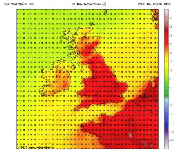
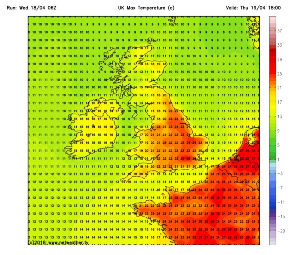
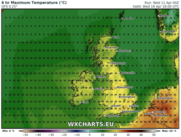
Predicted Maximum Temperatures for midweek next week –  30°C possible

Outlook: High pressure in charge and temperatures rising. We look likely to develop a southeasterly flow which will drag in hot air from the continent. We could be seeing values of 25-28°C quite widely. This is expected to continue throughout the week with no sign of any significant rain. As well as some hot sunshine during this period we will see some variable cloud at times. At this stage it looks like the weather will become cooler from around the 2nd of July.

Remember at this time of year the sun is very strong, UV levels are HIGH at 7 or higher, so apply sun-cream if you’re planning to be out in it for a while, otherwise you will burn regardless of what the temperature is.

Follow @ChadWeather on Twitter for the latest forecasts.

Thanks,
Jon

Forecast issued: Wednesday the 20th of June at 10am.
Image: https://www.netweather.tv/

Thursday 14th June 2018 – Sunday 17th June 2018

Hi all,

I’m back, after a wonderful week in Kos with days of hot sunshine, temperatures into the 30s and even a storm one evening to top it all off. I was hoping the weather in the UK would have been awful while I was away but it’s continued to be reasonable. Now I’m back so is the Jet Stream and a change in our weather pattern.

The lack of rain is certainly starting to have an effect on the local reservoirs and gardens. Some welcome rain ahead but long-term for the rest of June I’m thinking not enough. Some media report a 3-month heatwave. They’ve clearly had too much vodka or sun, or perhaps both :).

Jetstream

The Jet Stream is back

Thursday: A change to something we haven’t seen for a while. The Jet Stream will bring in an active area of low pressure, a little unseasonal for the time of year. Any morning rain will clear quickly leaving bright spells and a few scattered showers. It will also be very windy, especially during the morning with a warning in place for gusts to 55mph. Apart from the wind not a bad day at all just feeling cooler. Max 17°C

Friday: A quieter day with mostly cloudy skies, some bright spells and the odd shower here and there. Max 17°C

Weekend: Sunday looks the best.

Saturday: Another weather front will come in from the west with a band of rain then hefty showers, some of which could be thundery later. Breezy for a time. Max 16°C

Sunday: Drier with pleasant sunny spells developing. Most places a little warmer and drier but we can’t rule out a scattered shower. Max 18°C

Outlook: Patchy rain and cloud on Monday, after that high pressure will start to build again from the southwest, nudging the Jet Stream further north again, so becoming settled with warm, sunny intervals.

Follow @ChadWeather on Twitter for the latest forecasts.

Thanks,
Jon

Forecast issued: Wednesday the 13th of June at 6pm.
Image: https://www.netweather.tv/


Thursday 24th May 2018 – Bank Holiday Monday 28th May 2018

Hi all,

You guys must be loving me at the moment. It’s not often I deliver good news but it’s another blog and another week of decent summer-like weather on the way, but, we have to discount Friday in that claim.

Remember at this time of year the sun is as strong as mid-July, UV levels are HIGH at 6/7, so apply sun-cream if you’re planning to be out in it for a while, otherwise you will burn regardless of what the temperature is.

Thursday: Warm with bright spells and dry. We will still have the steady breeze from the northeast and with that, more cloud than we have been seeing recently. That said, it will still be feeling pleasant in any sunshine. Max 20°C

Friday: A day off from the decent weather. Cloudy with rain during the morning coming in from the east. Some of this could be heavy and thundery. A bit brighter later but with a few scattered beefy showers. Much cooler. Max 15°C

Extended Weekend: Sun-cream and BBQs are on the menu.

Saturday: Some cloud leftover from yesterday with perhaps a scattered early shower to start the day. The sun will get to work on this cloud, allowing it to break up and return us to what we are getting accustomed to. Sunny spells and dry for the rest of the day. Also, notably warmer again but still breezy. Max 20°C

ukmaxtemp

Sunday: Sunny and dry with temperatures rising. Feeling muggy and humid later as we drag in air from France. Hot in places. Max 24°C but this could go a degree or two higher.

Bank Holiday Monday: Very warm with plenty of strong sunshine. A chance of evening thunderstorms breaking out [one to watch]. Max 23°C

Throughout the forecast we will keep a steady breeze which will help you to cool off during the day but also make it a little cool in some of the evenings.

Outlook: Downpours and thunderstorms will introduce fresher air but this should be followed by sunny spells and mainly dry conditions once again.

Follow @ChadWeather on Twitter for the latest forecasts.

Thanks,
Jon

Forecast issued at 8:10pm on Wednesday the 23rd of May 2018
Image: https://www.netweather.tv/


Thursday 17th May 2018 – Sunday 20th May 2018

Hi all,

May is turning out to be a decent month and this settled, warm pattern with little rain, is set to continue. I’m sure we will pay for this during the summer months so grab it while you can.

Thursday: Still not as warm as earlier in the week but a good day in prospect. Sunny spells with yesterday’s breeze easing. Max 15°C

Friday: Settled with lengthy spells of sunshine. Temperatures back on the rise. Max 17°C

Weekend: Simply lovely.

Saturday: Warm with sunshine across the region. Light winds so really feeling summer-like. Max 21°C

Sunday: Little change. Just probably more in the way of cloud bubbling up especially so in eastern parts. Warm and dry. Max 21°C

Outlook: Similar to last Wednesday on Monday with cloud spreading down from the northwest. This will bring a very weak band of rain which will fizzle out. It will turn cooler though. After that high pressure reestablishes itself so we will be dry and become warmer again with sunny spells.

Looking towards the Bank Holiday Weekend and it currently pans out with high pressure in charge which means warm sunny weather – but don’t take this literally this far out.

Remember at this time of year the sun is as strong as late-July, UV levels are HIGH at 6, so apply sun-cream if you’re planning to be out in it for a while, otherwise you will burn regardless of what the temperature is.

Follow @ChadWeather on Twitter for frequent updates.

Forecast issued at 5:45pm on Wednesday the 16th of May 2018.

Thanks,
Jon

Thursday 3rd May 2018 – Bank Holiday Monday 7th May 2018

Hi all,

After a reasonable April we move into May with some decent, settled weather on the way and it’s not often we can say that with a Bank Holiday approaching.

Thursday: A chilly start with high pressure building to the southwest of the UK starting to settle the weather down after Wednesday’s rain. Mostly dry with some bright spells. However, a little later, the airflow will thicken the cloud and there could be some isolated areas of drizzle. Max 13°C

Friday: Plenty of cloud again, but with some bright spells thrown in, especially to the east. Just a low chance of a shower breaking out over the hills as temperatures begin to rise. A south-westerly breeze but warmer. Max 17°C

Weekend: It could be a lot worse with it being an extended one.

Saturday: Some sunny spells developing. Feeling very warm, especially in any sunshine. Max 20°C

Sunday: Pleasant sunny spells. A northwesterly breeze will develop so a little cooler and perhaps cloudier later. Max 19°C

Bank Holiday Monday: This is rare! It’s a Bank Holiday and we’ll have very warm sunny spells and it will be dry. Max 21°C

Remember at this time of year the sun is as strong as mid-August, UV levels are 5 to 6, so apply sun-cream if you’re planning to be out in it for a while, otherwise you will burn.

Outlook: A couple more days of settled dry weather with sunshine before a change. This change brings low pressure to the northwest of the UK allowing it to turn cooler and showery. This is not set in stone but just the more likely outcome.

April 2018 Stats

Max 22.8°C (19th)
Min 0.4°C (5th)
Av. 8.8°C
Wettest 22.2mm (2nd)
Windiest 35mph
Rain 78.8mm
Rainy Days 17
Dry Days 13

Follow @ChadWeather on Twitter for the very latest.

Thanks,
Jon

Thursday 19th April 2018 – Sunday 22nd April 2018

Hi,

As promised in last week’s blog, sunnier and warmer weather is coming, bringing us our first taste of summer. I also mentioned that it was set to break over the weekend and this is still the case. This is the time where gardens grow so fast you’ll have to give in and finally cut the lawn and perhaps you sneak in the first BBQ of the season.

Thursday: Breezy but a lovely day with sunny spells and very warm. Warmest day of the year so far. Dry. Max 22°C

Thursday will be the warmest day of the year so far

Friday: A misty start in places but another nice day with sunny spells. We lose the warm southeasterly wind direction for today and switch westerly meaning it will be a cooler. Max 17°C

Weekend: Saturday’s best.

Saturday: Little change during the day. Sunny spells, very warm and pleasant. Cloud will bubble up though and there is a chance of showers breaking out into the evening as high pressure slips away. Max 19°C

Showers possible later on Saturday becoming more widespread and perhaps thundery on Sunday

Sunday: The breakdown arrives with heavy, perhaps thundery showers spreading in from the west. Cooler. Max 16°C

Throughout the period UV levels will be between 4-5 and the sun is as strong as late-August. So don’t forget your sun-cream if you’re out in it for a long period of time.

Outlook: All change as our weather starts to come in from the Atlantic again. So, cooler, cloudier and eventually wet with rain at times. Temperatures back into the teens. So make sure you enjoy this warm spell.

Follow @ChadWeather on Twitter for the latest weather forecasts.

Thanks,
Jon

Forecast Issued on Wednesday the 18th of April 2018 at 2:10pm.
Images: https://www.netweather.tv

Thursday 12th April 2018 – Sunday 15th April 2018

Hi all,

Finally some warmer weather on the horizon. This time next week I might have dug the shorts out and be planning a BBQ. Of course this is all down to the forecast panning out as planned over the next 6-8 days. We deserve something settled, sunny and warm so fingers crossed.

Thursday: A mostly cloudy day with a cool easterly breeze still affecting the region. This might drag in some drizzle or light rain at times, especially during the morning. Cold. Max 9°C

Friday: Little change. Hopefully less in the way of drizzle and some brightness breaking through here and there as we enter the afternoon. A touch less cold. Max 12°C

Weekend: Mostly dry, slowly warmer.

Saturday: Dry but mostly cloudy,  thickest the further west you are. Just a chance of some isolated patchy drizzle for the morning. Milder. Max 14°C

Sunday: Bright spells and again most areas dry. Southerly winds helping to lift the temperature and we should see some warm sunny spells late in the day. Max 16°C

Temps Wed

Temperatures up to 20°C by Wednesday next week

Outlook: High pressure building and dragging warmer air up from the south/southeast. Cloudier and breezier in western areas otherwise sunny spells and warming up nicely. I’m not promising wall-to-wall sunshine but more so sunny intervals. UV levels in the sunshine up to 4/5, so time to work on your tan and sun-cream routine. We could well sneak a 20°C by midweek and see our warmest weather since August 2017, if we beat 20.2°C. How long will it last? This warm spell looks set to break over the weekend.

Forecast issued at 9:45am on Wednesday the 11th of April 2018.
Images: http://wxcharts.eu

Thanks,
Jon

Thursday 5th April 2018 – Sunday 8th April 2018

Hi all,

Winter has had a final few bites at us over the past few weeks, with some snowfalls and the bitter wind from the ‘Beast from the East 2’. We even managed snow on Easter Sunday, but don’t be surprised. Snow at Easter is more likely than snow at Christmas. March overall was a colder-than-average month but much drier than normal. It did actually rain on 23 days of the 31, but amounts were small. Is that the last of the snow? Yes, I think so.

UV Levels 04-04-2018

UV levels up to 3 and 4 on Thursday. Time to soak up the sun’s rays.


Thursday:
A cold and frosty start for some, but a lovely day ahead with pleasant sunny spells. Dare I say it, UV levels are now up to 3-4 which means you will catch the sun if you’re out in it for a few hours and we’ll soon we talking about sun-cream again! Max 11°C

Friday: A dry morning with sunny spells. Cloud increasing into the afternoon with rain arriving after dark. Milder as winds increase and drag up air from the southwest. Max 13°C

Saturday: Cloudy with some rain but this should ease away during the day with some bright spells developing later on. A few evening showers are possible. Max 12°C

Sunday: A mostly overcast day but some sunny spells developing later and it should be mostly dry. Any decent sunny spells will lift the temperatures quickly. Max 13°C

Outlook: A cloudy set-up and quite cool. Perhaps signs of something a little warmer past mid-month. Sooner or later a decent Spring spell will arrive.

Follow @ChadWeather on Twitter for the latest forecasts.

March 2018 Stats

Max 13.7°C (10th)
Min -5.9°C (1st)
Av. 4.4°C (colder than average)
Wettest 8.2mm
Windiest 47mph
Rain 51.8mm (57% of average)
Rainy Days 23
Dry Days 8
Air Frosts 8 (more than average)
Snow Falling Days 4
Snow Lying Days 6

Thanks,
Jon

Forecast Issued at 5pm on Wednesday the 4th of April 2018.
Image: http://weatheronline.co.uk


Thursday 29th March 2018 – Bank Holiday Monday 2nd April 2018

Hi,

More media speculation this week. After getting lucky, even a broken clock is right twice a day :), with predicting ‘The Beasts’ more than a week out, this time they are wrong. No ‘Beast from the East 3’.

Thursday: Cold with some frost and mist to start the day. Sunny spells for the morning but heavy, possibly thundery, showers will arrive from the south late-afternoon and into the evening. Some of these wintry over high ground. Max 10°C

Good Friday: Mostly cloudy with some brightness. Showery rain which again could be heavy and wintry on the hills arriving later into the evening. Feeling cool. Max 8°C

The Extended Weekend: Sunday probably the best.

Saturday: Early rain moves away and eases quickly during the morning. Bright spells will develop but also some showers which will fade away later. Max 8°C

Easter Sunday: It should be mostly dry with bright spells after a misty start. Like other days it will still be quite cool with temperatures below average. Max 8°C

Bank Holiday Monday: Sunny spells for the morning but cloud thickening with rain arriving from the southwest during the day which could give some snow on the hills. Eventually milder. Max 8°C

Outlook: Remaining unsettled with temperatures on the chilly side. Some rain at times, which could have a wintry mix over the Pennines. So, disappointing news if you’re on the lookout for some Spring warmth. I know I am.

Follow @ChadWeather on Twitter for the latest weather forecasts.

Thanks,
Jon

Forecast Issued: 4:15pm on Wednesday the 28th of March 2018

Thursday 22nd March 2018 – Sunday 25th March 2018

Hi all,

Last week we discussed the ‘Beast from the East 2’, the sequel etc. and it certainly delivered. To be honest the amount of snow it brought even surprised me. The wind was also a feature bringing a severe wind-chill and snow drifts up to 4 feet high. It was only a short-lived affair, basically freezing us for the weekend and it wasn’t as intense as the previous Beast, but it was certainly impressive for the second half of March. Of course the media have jumped on this opportuinity to say number 3 is coming and we will see snow at Easter, but what is the realistic outlook?

‘Beast from the East 2’ Stats

  • The temperature dropped 6°C in 90 mins as colder conditions arrived on Friday
  • Snow fell most of Saturday afternoon and overnight
  • Widely 8cm of snow-cover
  • Snow drifts up to 4ft
  • Many road closures
  • Lowest wind-chill of -10°C
  • Lowest feels-like temperature of -11°C
  • Sunday didn’t see the temperature rise above freezing
  • Wind gusts of 50mph locally and especially on the hills felling some trees
Temp drop Beast 2

A rapid temperature drop as the ‘Beast from the East 2’ arrived last Friday

Thursday: Sunny spells and southwesterly winds freshening. It should remain dry until later in the evening and overnight when rain will arrive. Max 9°C

Friday: Early rain, some heavy clearing during the morning. Bright spells into the afternoon with a few showers, possibly thundery. Cool and breezy. Max 10°C

Weekend: Not bad at all, no dramas like last weekend.

Saturday: Apart from the odd shower it looks a reasonable day with sunny spells. Max 9°C

Sunday: A misty start, soon lifting to sunny spells and the odd rogue shower. With light winds it will feel pleasant in any sunshine. Max 10°C

Cold NE

Colder with a chance of snow showers by the time we get to Good Friday

Outlook: Remaining mild with temperatures close to double-figures. Some rain at times, especially into Tuesday, but brighter spells too. As we approach Easter the computer models are showing signs of a cold wind developing again. This looks to be from the northwest or north, but some signs are there for a northeasterly. This will bring lower temperatures and with it the risk of some wintry showers and snow. This looks to last 2-3 days, and yes you’ve guessed it, starting on Good Friday. So, at this current stage, no Beast from the East 3 exactly, but definitely not the Easter forecast you wanted to hear.

Follow @ChadWeather on Twitter for the latest weather forecasts.

Thanks,
Jon

Forecast Issued at 10:30am on Wednesday the 21st of March 2018
Image: wxcharts.eu