Thursday 29th March 2018 – Bank Holiday Monday 2nd April 2018

Hi,

More media speculation this week. After getting lucky, even a broken clock is right twice a day :), with predicting ‘The Beasts’ more than a week out, this time they are wrong. No ‘Beast from the East 3’.

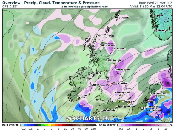
Thursday: Cold with some frost and mist to start the day. Sunny spells for the morning but heavy, possibly thundery, showers will arrive from the south late-afternoon and into the evening. Some of these wintry over high ground. Max 10°C

Good Friday: Mostly cloudy with some brightness. Showery rain which again could be heavy and wintry on the hills arriving later into the evening. Feeling cool. Max 8°C

The Extended Weekend: Sunday probably the best.

Saturday: Early rain moves away and eases quickly during the morning. Bright spells will develop but also some showers which will fade away later. Max 8°C

Easter Sunday: It should be mostly dry with bright spells after a misty start. Like other days it will still be quite cool with temperatures below average. Max 8°C

Bank Holiday Monday: Sunny spells for the morning but cloud thickening with rain arriving from the southwest during the day which could give some snow on the hills. Eventually milder. Max 8°C

Outlook: Remaining unsettled with temperatures on the chilly side. Some rain at times, which could have a wintry mix over the Pennines. So, disappointing news if you’re on the lookout for some Spring warmth. I know I am.

Follow @ChadWeather on Twitter for the latest weather forecasts.

Thanks,
Jon

Forecast Issued: 4:15pm on Wednesday the 28th of March 2018

Thursday 22nd March 2018 – Sunday 25th March 2018

Hi all,

Last week we discussed the ‘Beast from the East 2’, the sequel etc. and it certainly delivered. To be honest the amount of snow it brought even surprised me. The wind was also a feature bringing a severe wind-chill and snow drifts up to 4 feet high. It was only a short-lived affair, basically freezing us for the weekend and it wasn’t as intense as the previous Beast, but it was certainly impressive for the second half of March. Of course the media have jumped on this opportuinity to say number 3 is coming and we will see snow at Easter, but what is the realistic outlook?

‘Beast from the East 2’ Stats

  • The temperature dropped 6°C in 90 mins as colder conditions arrived on Friday
  • Snow fell most of Saturday afternoon and overnight
  • Widely 8cm of snow-cover
  • Snow drifts up to 4ft
  • Many road closures
  • Lowest wind-chill of -10°C
  • Lowest feels-like temperature of -11°C
  • Sunday didn’t see the temperature rise above freezing
  • Wind gusts of 50mph locally and especially on the hills felling some trees
Temp drop Beast 2

A rapid temperature drop as the ‘Beast from the East 2’ arrived last Friday

Thursday: Sunny spells and southwesterly winds freshening. It should remain dry until later in the evening and overnight when rain will arrive. Max 9°C

Friday: Early rain, some heavy clearing during the morning. Bright spells into the afternoon with a few showers, possibly thundery. Cool and breezy. Max 10°C

Weekend: Not bad at all, no dramas like last weekend.

Saturday: Apart from the odd shower it looks a reasonable day with sunny spells. Max 9°C

Sunday: A misty start, soon lifting to sunny spells and the odd rogue shower. With light winds it will feel pleasant in any sunshine. Max 10°C

Cold NE

Colder with a chance of snow showers by the time we get to Good Friday

Outlook: Remaining mild with temperatures close to double-figures. Some rain at times, especially into Tuesday, but brighter spells too. As we approach Easter the computer models are showing signs of a cold wind developing again. This looks to be from the northwest or north, but some signs are there for a northeasterly. This will bring lower temperatures and with it the risk of some wintry showers and snow. This looks to last 2-3 days, and yes you’ve guessed it, starting on Good Friday. So, at this current stage, no Beast from the East 3 exactly, but definitely not the Easter forecast you wanted to hear.

Follow @ChadWeather on Twitter for the latest weather forecasts.

Thanks,
Jon

Forecast Issued at 10:30am on Wednesday the 21st of March 2018
Image: wxcharts.eu


Thursday 13th April 2017 – Bank Holiday Monday 17th April 2017

Hi all,

I hope you all enjoyed our first warm spell of the year last weekend and got some sunbathing or a BBQ in before the weather changed quickly on the Sunday afternoon. In fact, the temperature dropped from 18°C to 11°C in just a couple of hours.

Big temperature drop last Sunday as winds turned NW-ly.

So, will the warm sunny weather return in time for Easter?

Headline: Changeable with Monday, followed by Saturday, looking the best days of the Easter Holidays.

Thursday: A day of some bright spells but generally cloudy. We might catch the odd shower during the morning. Cool breeze. Max 11°C

Good Friday: Don’t expect much in the way of sunshine. Mostly cloudy with a spell of light rain likely which will turn drizzly later. Cool. Max 10°C

Saturday: Cloudy with some showers during the morning but hopefully an improvement into the afternoon as the showers ease and it turns brighter. Max 10°C

Rain moving in on Easter Sunday

Easter Sunday: Any early brightness fades as cloud thickens and rain arrives from the west. A little uncertainty on how wet it gets as the rain might slip a little further south. Feeling cold with a freshening breeze. Max 10°C

Bank Holiday Monday: Hopefully, a little ridge of high pressure moves across the country, so after a chilly start with a possible ground frost, a dry day with sunny spells and a little milder. A chance of some rain from the west late-afternoon or into the evening. Max 12°C

A chilly northerly wind later next week

Looking Ahead: Some spells of showery rain but not amounting to much. Later in the week it remains cool as winds could turn northerly.

Keep up to date with your local forecast by following @ChadWeather on Twitter.

Thanks,
Jon

Images: https://www.wunderground.comhttp://www.theweatheroutlook.com

Forecast Issued: 11am on Wednesday April the 12th 2017

Thursday 17th March 2016 – Sunday 20th March 2016

Hi all,

In my terms, we are in a pattern of settled but boring weather. Not too warm, not too cold, no frost, no snow, no rain, some dull days, some bright days but nothing to keep an eye on. The only positive, is it gives me a bit of a well-earned, much-needed rest.

With the settled pattern set to continue I will have a look at the outlook for Easter and give a ‘most likely’ forecast rather than the media tripe that has already been published.

easter media bull

A usual Daily Express headline rears its ugly head again – No signs of a heatwave

A chilly start on Thursday, and if we have had clear spells for long enough then perhaps a touch of frost and some fog patches. These will lift into low-cloud but sunny spells expected during the day. Max 8°C.

We have high pressure firmly in charge of our weather hence the dry and settled spell but as we enter Friday this will slip to sit to the northwest of Ireland meaning we drag in a cold northerly breeze. However, another dry day with bright spells is on the cards. Some areas may keep some stubborn cloud. Feeling chilly. Max 7°C.

saturday pressure chart

High pressure that’s giving us settled weather drifts into the Atlantic

The weekend will be mostly dry but I can’t promise wall-to-wall sunshine.

Saturday and Sunday will be similar. A cool breeze from the north and with it plenty of cloud floating around. Some of this may be thick enough to bring some drizzle or light rain to unlucky spots but quite localised. It will remain feeling cold but pleasant in any sunshine. Overnight frost will be possible where we have clearing skies. Max 8°C.

Looking ahead and little change for most of next week but there are signs that we will see the high pressure drift away as we approach Easter. This will allow some rain to push in from the northwest followed by a chilly southeasterly breeze. No heatwave on the radar, with it even being cold enough for some frost over Easter Weekend. Of course look out for updates on Twitter as it is still 10 days away.

frosty start to easter weekend

Possibly a frosty start to the Easter Weekend

risk of a wet easter sunday

A risk of rain on Easter Sunday

easter sunday max temp

Predicted maximum temperatures for Easter Sunday – certainly no heatwave

Follow @ChadWeather on Twitter to catch all the latest weather updates for Manchester and its surrounding boroughs.

Thanks for reading,

Jon

Photos/Data: http://www.ukweatherforecast.co.uk, www.metoffice.gov.uk, www.netweather.tv

Forecast issued at 13:30 on Wednesday the 16th of March 2016