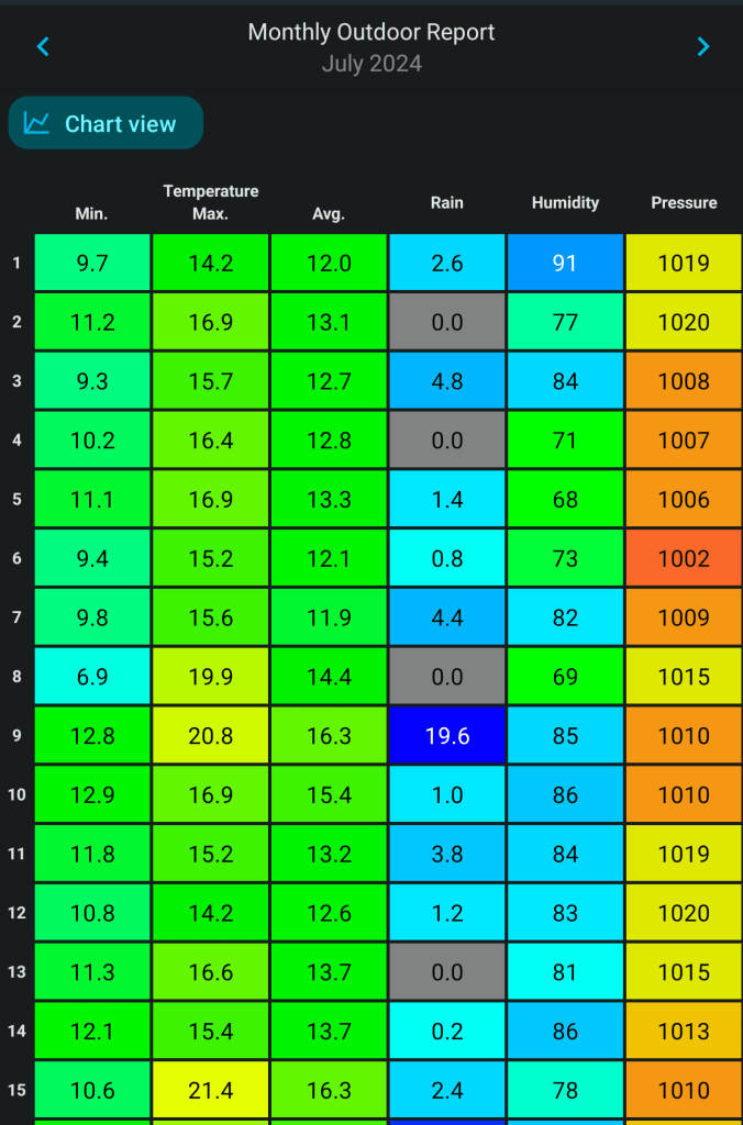
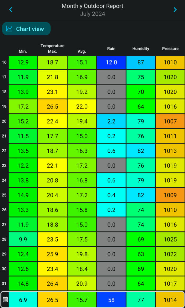
July’s stats are in. Like June, it was drier-than-average, with only 66% of the average monthly rainfall falling.
July 2024 Stats
July 2024 Stats – 1st to 15thJuly 2024 Stats – 16th to 31stAfter a wet 2024, June and July have been drier-than-average.
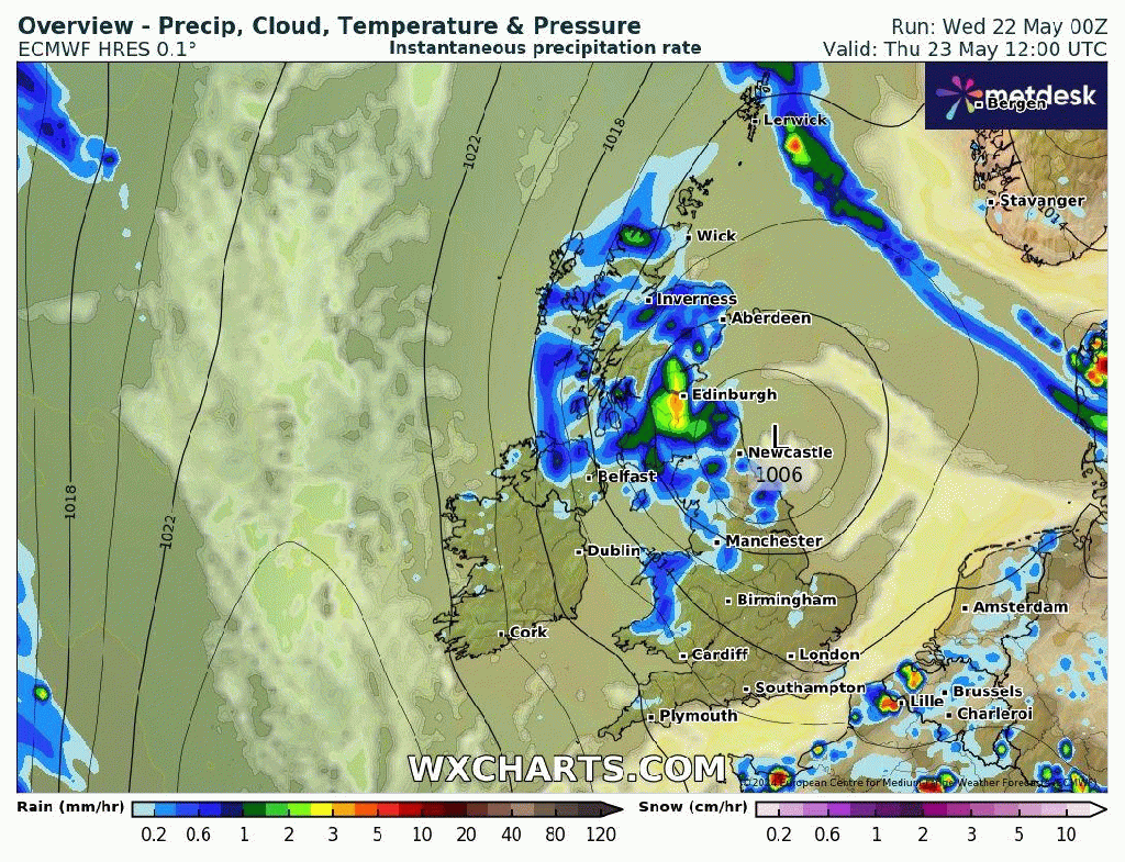
Thursday: We have a small feature moving in from the south west. This is going to bring a wet day with pulses of rain turning showery later. Breezy with temperatures around average but it will feel muggy and with low-cloud on the hills. Max 20°C Min 13°C
Friday: Yesterday’s weather system will move out of the way and a cold-front will introduce fresher air from the west and it will be a day of bright spells and showers. The showers should be well-scattered though and we will get some decent sunny spells in between. The only downside will be, it will be gusty with 35mph winds. Max 20°C Min 12°C
Weekend: Sizzling Sunday.
Saturday: Not a bad day with sunny spells and the chance of a shower later as cloud bubbles up. Breezy. Pleasantly warm. Max 22°C Min 13°C
Sunday: A plume of hot air will move up from the south. That said the first half of the day is expected to see a lot of cloud with very warm-to-hot temperatures developing into the afternoon as cloud breaks and sunny spells arrive. Muggy especially later and overnight. Max 25-27°C Min 16°C
Hot for us on Sunday but by Monday the heat is confined to the SE with 33°C possible
Outlook: The heat will ease away during Monday, but how quickly this happens is still not certain. Could be another hot day with some pleasant sunny spells, or temperatures could be around normal, with a risk of thunderstorms later. The rest of the week looks a bit unsettled with showers and bright spells as well as becoming breezy and temperatures around or just below normal.
Follow @ChadWeather on X for the latest forecasts and warnings.
Thanks,
Jon
Forecast Issued: Wednesday the 7th of August 2024 at 8:27pm
The weather is sort of uneventful at the moment with little in the way of mobile conditions and with brief ridges of high pressure bringing warm, settled conditions but without any wall-to-wall sunshine. Basically average. It’s not too wet at the moment either and not much rain is expected, so time to start watering those lawns and gardens.
We might not be hot on the thermometer but that’s still a strong sun up there and it’s very warm when it’s out and the UV levels are still high.
Hard to believe August is almost here. Yep, the last month of “summer”.
Thursday: It will be a muggy day with moist southwesterly winds which will be quite breezy during the morning. Cloud will be thick enough to produce some drizzle early on, but cloud should tend to thin later into the afternoon and we should see the odd bright spell which could set off a localised shower. Max 21°C Min 13°C
Quite muggy on Thursday with SW winds
Friday: A better day in prospect with plenty of sunny spells, but it will be windy. Most of any showers should stay confined to the northwest of the UK, but it’s still possible that we could catch an isolated one during the afternoon. Less humid than Thursday with fresher air in place. Max 20°C Min 12°C
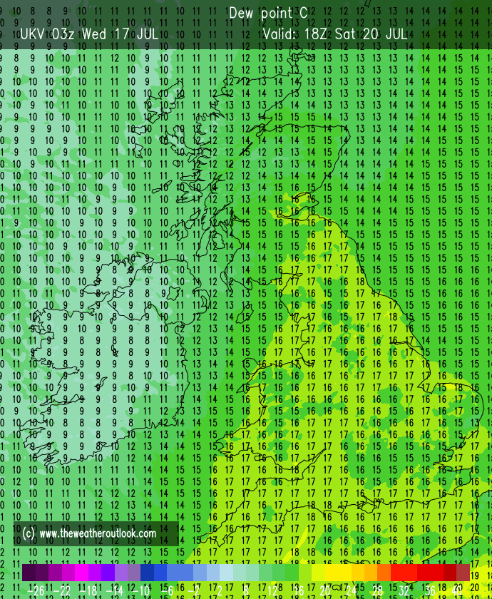
Lower dew points on Friday means fresher air will be in place.
Weekend: Sunday looks best.
Saturday: Sunny spells and showers. Some of them could be heavy and the wind will veer northwesterly at times and be a little gusty, especially during any downpours. If you’re lucky enough to avoid showers then it should be quite a reasonable day with showers easing towards evening and therefore we should see more in the way of sunshine. Max 20°C Min 11°C
Showery on Saturday
Sunday: We’re looking at a dry day with sunny spells and lighter winds compared to Saturday. Feeling pleasant in the sunshine and don’t forget you still burn easily at this time of year. Warmer. Max 23°C Min 12°C
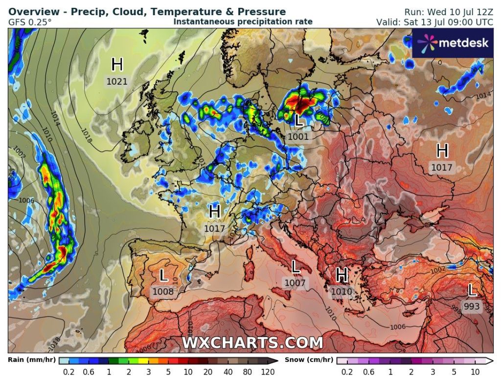
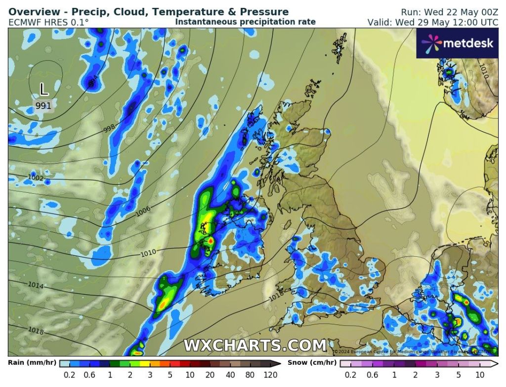
Outlook: It looks like next week we will see a bit more of an influence from the Jet Stream. So we could see a couple of areas of low pressure bringing spells of rain and wind. In between the Azure’s high pressure will ridge up across the southwest of the country, so will give us some brighter days and drier days in between.
Not that much rain expected in the next 10 days. I think this graphic is a little optimistic but we will see.
Follow @ChadWeather on X for the latest forecasts and warnings.
Thanks as always for stopping by to read.
Jon
Forecast Issued: Wednesday the 24th of July 2024 at 5pm.
Finally something much warmer, briefly hot, but it’s not here for long before temperatures return back to normal for the weekend. But, it will be welcome after July has been disappointingly cool. Up to Tuesday, July was, on average, cooler than June and May! But warmer temperatures this week, especially with muggy nights, will lift the average somewhat.
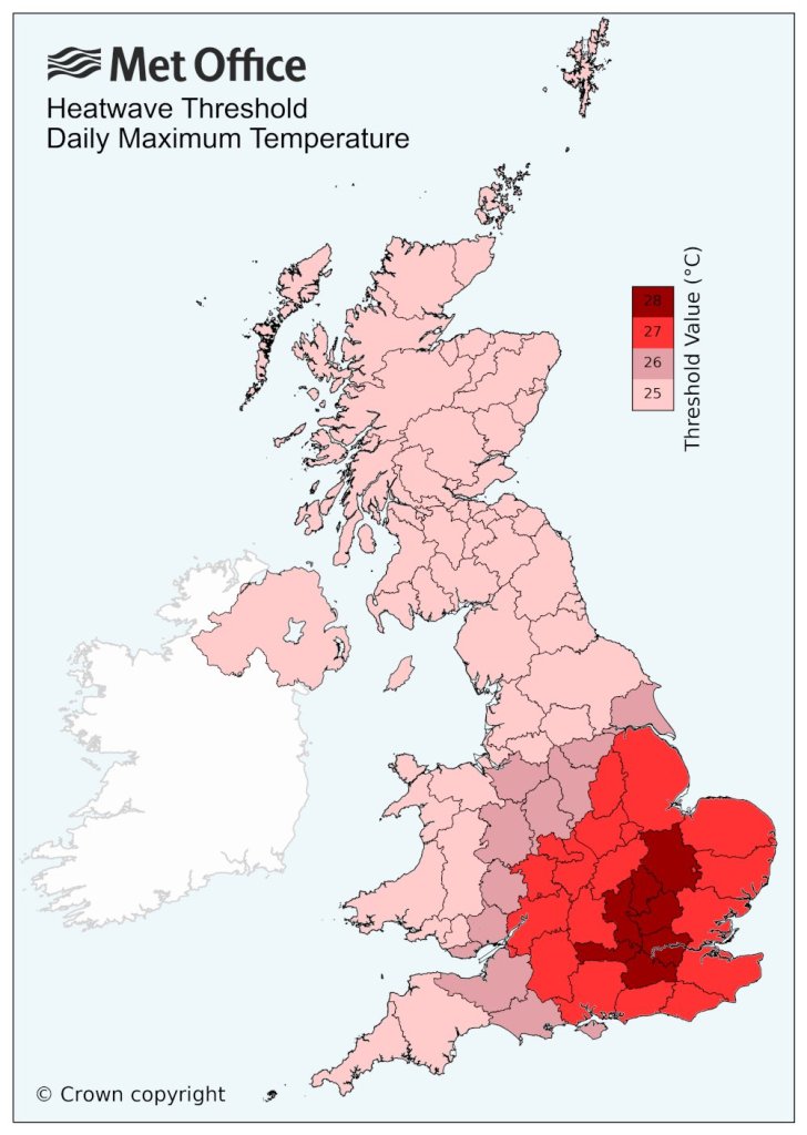
Just to note: There isn’t a heatwave coming to the region despite what the media report and that includes a ‘mini-heatwave’ as they don’t exist.
The threshold for a heatwave, 25°C, has to be met for 3 consecutive days and this will not be met over the next few days.
Thursday: Mostly cloudy with the odd bright spell for the morning with the odd scattered shower out west. Any sunshine will tend to become hazy as cloud spills in from the west after lunchtime and some showers could run up the western side of the region later. Humid night. Max 24°C Min 16°C
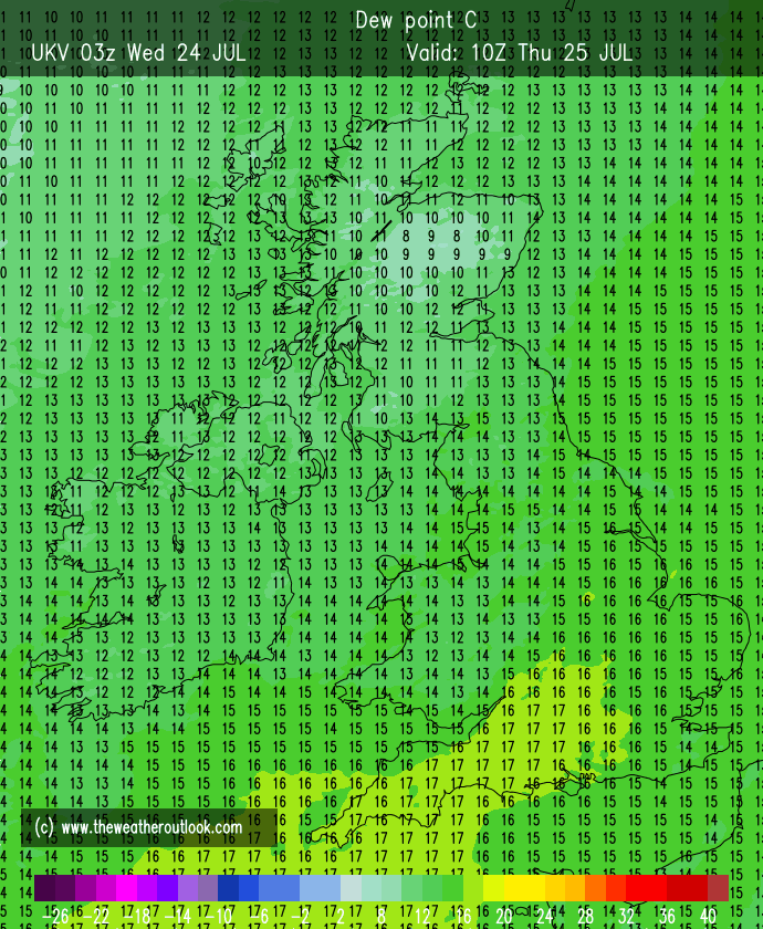
Friday: A very warm-to-hot day, depending on how far northwest the heat from the southeast can reach. Sunny spells and it should remain dry with just the outside chance of a shower. Warm night. Max 25-27°C Min 15°C
Weekend: We lose Friday’s heat and temperatures will return to around normal after a cold-front moves through. Turning unsettled during Saturday.
Muggy Saturday evening with high dew points
Saturday: Sunny spells for the morning but then cloud will increase and a band of thundery showers will move through later in the day. This will introduce much cooler air. Breezy later. Max 23°C Min 12°C
The heat breaks during Saturday where we could see some hefty downpours and thunderstorms later in the day
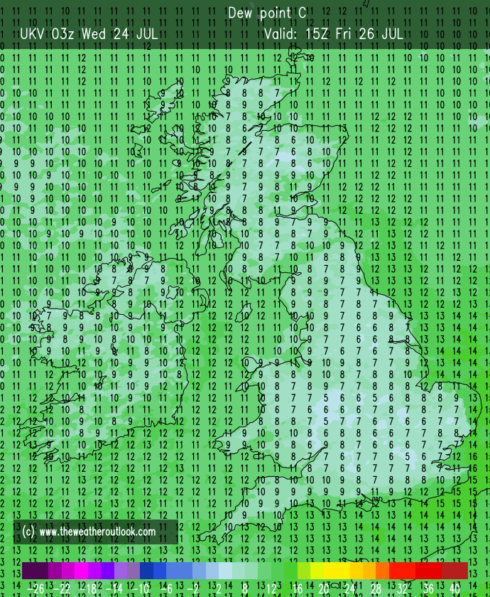
Sunday: A better day with sunny spells but only after morning showers have eased away. Much fresher now and windy at times too. Max 20°C Min 11°C
Much fresher air arrives for Sunday
Outlook: I can’t see any sign of another warm/hot spell with conditions/temperatures expected to be disappointing for the time of year with occasional bright spells and showers. So generally unsettled but with the odd drier spell in between bands of showers.
I guess September will be a decent month then? Because summer isn’t behaving.
Follow @ChadWeather on X for the latest forecasts and warnings.
Thanks,
Jon
Forecast Issued: Wednesday the 17th of July 2024 at 4:36pm.
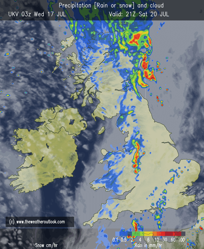
The miserable summer continues and although it’s been muggy at times this week, especially on Tuesday, there’s been quite a bit of rainfall and Tuesday saw most places see up to an inch of rain followed by evening thunderstorms in the west.
High pressure is going to try its best to squeeze in from the west as we head towards the weekend but it won’t establish itself fully over the UK; so it’s not going to be exclusively dry even though the weather will settle down a little bit. Looking ahead, no sign of any summer heat returning just yet, but perhaps a hint of something a few degrees warmer in about a week’s time.
Thursday: Unfortunately, a weak weather-front will establish itself across the region. We can expect a cloudy day with patchy rain here and there and some drizzle during the morning. During the afternoon the patchy rain and drizzle should turn into scattered showers with the odd heavy one. Max 17°C Min 11°C
Friday: It should be a better morning on Friday with a few bright spells but cloud will bubble up as the day wears on and there will be the odd scattered shower but some places will stay dry. We’ll have a cooler airflow now so it won’t feel as muggy as it has done earlier in the week. Max 17°C Min 11°C
Showers this weekend
Weekend: High pressure close by but we can still expect showers.
Saturday: High pressure to the northwest of the UK. Low pressure over in Europe. In between a little bit of instability meaning a bright start but clouds will bring the odd scattered shower into the afternoon, which could be heavy. Max 17°C Min 10°C
Sunday: Little change really, bright spells for the morning, clouds bubbling up later producing some scattered showers, which could be heavy again and thundery. Not much change in the maximum temperature. Max 18°C Min 11°C
Cooler-than-average this weekend
Outlook: It looks like it will remain changeable throughout the week. Bright spells and showers developing and temperatures likely to stay just below average. Later in the week there are hints that maybe a little bit of warmer air will waft up from the south, but with this being 7 to 9 days away there is still a lot of uncertainty on this occurring. The wait for our summer heat in July continues.
Follow @ChadWeather on X for the latest forecasts and warnings.
Thanks,
Jon
Forecast Issued Wednesday the 10th of July 2024 at 9:15pm
Well summer finally arrived but not exactly wall-to-wall sunshine, but instead sunny spells, dry, very warm and humid conditions.
It took a while but finally we had a day in June that was warmer than the warmest day in May.
After a cool June for most of the month, the averages for May and June are now close. June’s average was running well below May until this recent summery spell.
June’s average is still below May. Remember May was the mildest on record, mostly down to the warm nighttime temperatures. Also, it’s been a drier-than-average month.
What has also been noticeable, if you’ve done your garden recently; is that it is drying out somewhat.
Currently June has only had 50% of its expected monthly rainfall. Some areas down in the southeast of England are sitting at only 10%. Currently it’s a 50/50 split with 13 days dry and 13 days with measurable rainfall.
But, cooler and fresher air is on the way as an area of low pressure, bringing gales to NW Scotland, pushes away the heat and humidity through Thursday.
Low pressure swings in on Thursday to introduce fresher air.
Thursday: The cooler air will arrive Thursday morning as a weakening cold-front moves through. The day will start with a narrow band of patchy rain followed by sunshine. Sunny spells continue but some showers are possible, especially out west later in the day, most likely in the evening. Much cooler and fresher and turning windier later. Max 20°C Min 12°C
Friday: After a few early showers and perhaps a longer spell of rain, the showers will ease and the afternoon should be an improving picture with sunny spells developing. Windy though and this will make it feel like the mid-teens as temperatures return to below the average. Max 17°C Min 11°C
Weekend: Temperatures below par.
Saturday: It’s expected to be cloudy with some splashes of rain here and there. Not as windy as recently so not feeling as cool. Max 18°C Min 10°C
Sunday: Sunday looks a fine day and hopefully a dry day. Sunny spells for the morning with cloud bubbling up during the day. Breezier again and temperatures disappointing. Max 17°C Min 12°C
Outlook: Poor for the time of year. Mostly cloudy at times with some showers and bright spells in between. Since the sun is strong, it will still feel pleasant where sunny spells occur. It will be occasionally windy and with the wind coming from a westerly or even northwesterly direction at times, temperatures will be below average with us struggling to reach 20°C. This pattern looks set to continue for the first week of July. Cue the, “that’s summer over” quotes.
Follow @ChadWeather on X for the latest forecasts and warnings.
Thanks,
Jon
Forecast Issued: Wednesday the 26th of June 2024 at 3:05pm.
I hinted a few weeks ago that the latter part of June should finally bring some warmer weather and this now looks like being the case. I’m no Mystic Meg but June just had to improve at some point as it was so bad.
The warmer feel to our weather starts today, Wednesday, with highs of 20°C and sunny spells. Very pleasant indeed, and personally I prefer that to any sweaty, humid heatwave.
Of course the warmer temperatures will lift the June average, as currently it was at values we would expect to see in October but it won’t be the “warmest” on record like May was (see last week’s post for more information).
So why is it getting warmer? It’s all down to a shift in the Jet Stream which will move north meaning we’ll be on the southern flank where the warmer air is.
Thursday: A cloudy start with some early mist then warm sunny spells will break through. Dry and feeling pleasant. Max 22°C Min 13°C
Friday: Warm with sunny spells but cloud will build later from the west turning the sun hazy. Chance of some patchy rain into the late-evening. Warm. Max 21°C Min 12°C
Weekend: A bit of a blip on Saturday with Sunday the better day.
Saturday: Early cloudy conditions with some patchy rain and showers. Showers will ease and the weather-front will weaken and some sunny spells are expected later. Max 20°C Min 11°C
Our weather is improving but Saturday will see a blip with patchy rain and showers moving east.
Sunday: A better day in prospect with warm sunny spells. Cloud bubbling up at times but remaining dry. Feeling warmer. Max 21°C Min12°C
Outlook: High pressure will mostly control the weather and with a southerly breeze it will gradually become warmer with sunny spells. Temperatures likely to reach 22-24°C, perhaps the probability of 25-26°C as the week progresses but from midweek it is uncertain how the weather will pan out. Some models go hot for England and Wales with a heatwave developing, others show a breakdown from the west to a cooler and showery theme. That said, at least the weather for now is turning more to what we would like to expect in June and certainly more summery.
Heatwave potential later next week but far from certain and more favourable for the SE of the UK. Any heatwave could well be followed by a thundery breakdown which isn’t unusual.
Follow @ChadWeather on X for the latest forecasts and warnings.
Thanks,
Jon
Forecast Issued: Wednesday the 19th of June 2024at 4:48pm
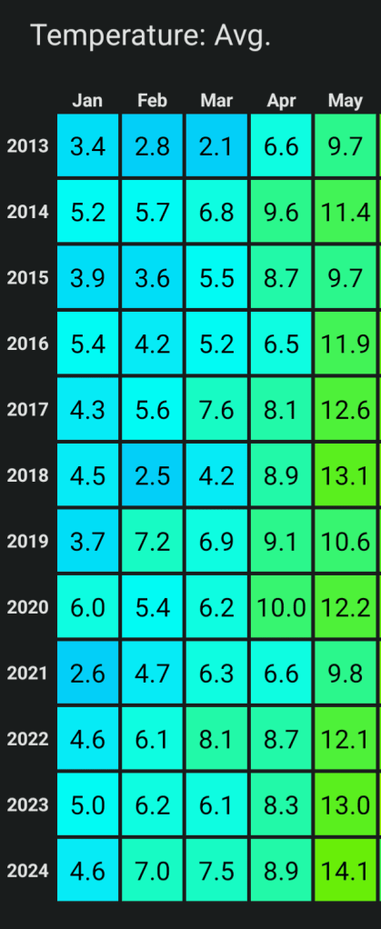
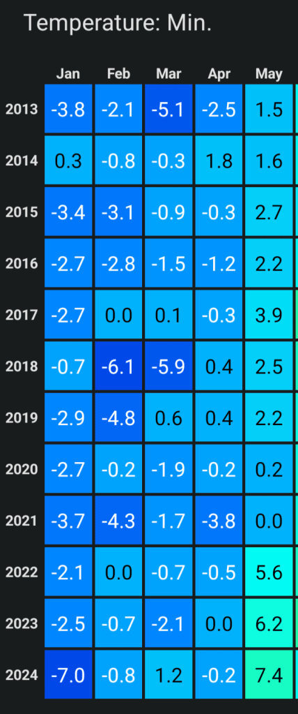
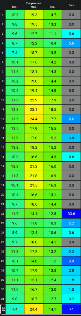
After a record-breaking May across the UK. Yes, it was the warmest (although I prefer the word mildest) on record and this was also the case for my dataset of weather records dating back to August 2012. I know it is only a small dataset but when you look at the average temperature and especially the nighttime temperatures you can see why.
There seems to be most of the general public who do not believe the statistics for May 2024. But what you’ve got to think about is why the statistics are doubted by many.
May 2024 was a cloudier month than normal, so during the daytime it didn’t feel warm on most days due to the lack of sunshine. Any kind of sunshine, regardless of temperature, in May feels warm to very warm due to the time of year. Cloudy nights meant very mild nights and it was these mild nights that lifted the average temperature value for May 2024 into record-breaking territory. And as you’re aware, most don’t notice the nighttime temperatures as they’re sleeping. Very warm sunny days can mean clear nights and nighttime temperatures into single-figures in May, even with localised ground-frosts but May 2024 was cloudier and much milder overnight. Again this is clear in the data.
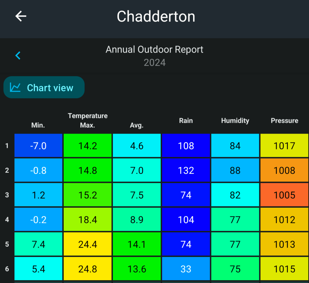
The coldest night was only +7.4°C and we only had 9 nights below 10°C.
The average temperature overall for May 2024 here was 14.1°C which beats previous Mays easily.
We also had 6 days where the temperature was 21-24°C. Not many remember that. 12 days were 19°C or above, which is above the maximum average.
We also had more dry days than wet days and apart from a very wet day (33.6mm) the other 30 days’ total rainfall was below average. Hard to believe.
So what made May 2024 so disappointing and forgetful: The lack of sunshine which is noticeable by many of us more than anything else.
May 2024 Statistics
June is poor so far and will likely be our first below-average temperature month for a long time. I do think some heat is coming; whether this be late on in June or early-July, remains to be seen.
A cool June so far with maximum temperatures very disappointing. Chilly nights too.
Thursday: A chilly start. Any early brightness fades as cloud thickens from the west and the breeze picks up. Rain will arrive around mid-afternoon. We’ll now have a southwesterly airflow so temperatures up a little but with that rise comes moisture. Max 16°C Min 12°C
Friday: Sunny spells and showers. The showers most frequent into the afternoon, and some heavy with hail and thunder. Max 17°C Min 11°C
Weekend: Low pressure firmly in charge.
Saturday: A day of bright spells to start with hefty thundery showers brewing. Catch one and it will be a downpour. Lighter winds and in any sunshine it will feel pleasant and warm. UV levels are high as always at this time of the year. Max 17°C Min 11°C
Sunday: The low pressure drifts a little further north so it’s a bit breezy, especially later. Otherwise, rinse and repeat. Bright spells and beefy showers. Risk of hail and thunder. Max 17°C Min 10°C
Outlook: Low pressure(s) close by. The warm bright spells and showery theme will continue. Temperatures around average, 17-19°C. If you see “heatwave on the way” in the media. Ignore.
We remain in the cooler-than-average air next week. Only the last week of June could see us return close to 20°C.
Follow @ChadWeather on X for the latest forecasts and warnings.
Thanks,
Jon
Forecast Issued: Wednesday the 12th of June 2024 at 5:55pm.
Apologies for no weekly blog over the last two weeks. A busy schedule meant time was limited. I’m back this week with a full 4-day forecast and an outlook after a very wet and miserable Wednesday.
Relentless Rain – 1-2 inches fell on Wednesday
Thursday: The low pressure responsible for Wednesday’s deluge will still be anchored across the UK and this will continue to bring spells of rain throughout the day. It will become patchier into the evening and it will be breezier than recently. Max 13°C Min 11°C
Friday: The low beings to fill but it will still mean a disappointing day with mostly cloudy skies and some showers at times. Muggy with lighter winds. Brighter spells later on are possible. Max 15°C Min 10°C
Weekend: Much warmer but still showery.
The low pressure will fill over the coming days and be replaced by higher pressure
Saturday: Sunny spells and with only the outside chance of a shower as cloud bubbles during the day, it’s a much-improved day. Feeling much warmer too. Max 20°C Min 13°C
Sunday: A weakening weather-front will mean a cloudier Sunday looks likely with bright spells and some heavy showers, which could be thundery. Max 18°C Min 10°C
Bank Holiday Monday: A ridge of high pressure will mean a day of warm sunny spells developing after early showers decay. Max 18°C Min 11°C
Outlook: A ridge of high pressure means it doesn’t stay around for long, so back to a theme of sunshine and showers with perhaps some longer spells of rain at times, especially after Tuesday. It will be a west or southwesterly air-flow so remaining on the average side in terms of temperature and a little humid at times.
Changeable next week
Follow @ChadWeather on X for the latest forecasts and warnings.
Thanks,
Jon
Forecast Issued: Wednesday the 22nd of May 2024 at 5:37pm.
I don’t know about you but I’m glad to get April out of the way. It will go down for a lack of sunshine but also for how wet it was in the first half of the month especially. You’d think it was colder-than-average but this was down to the cloudy and windy days and below average sunshine hours. Temperatures actually came out at around average.
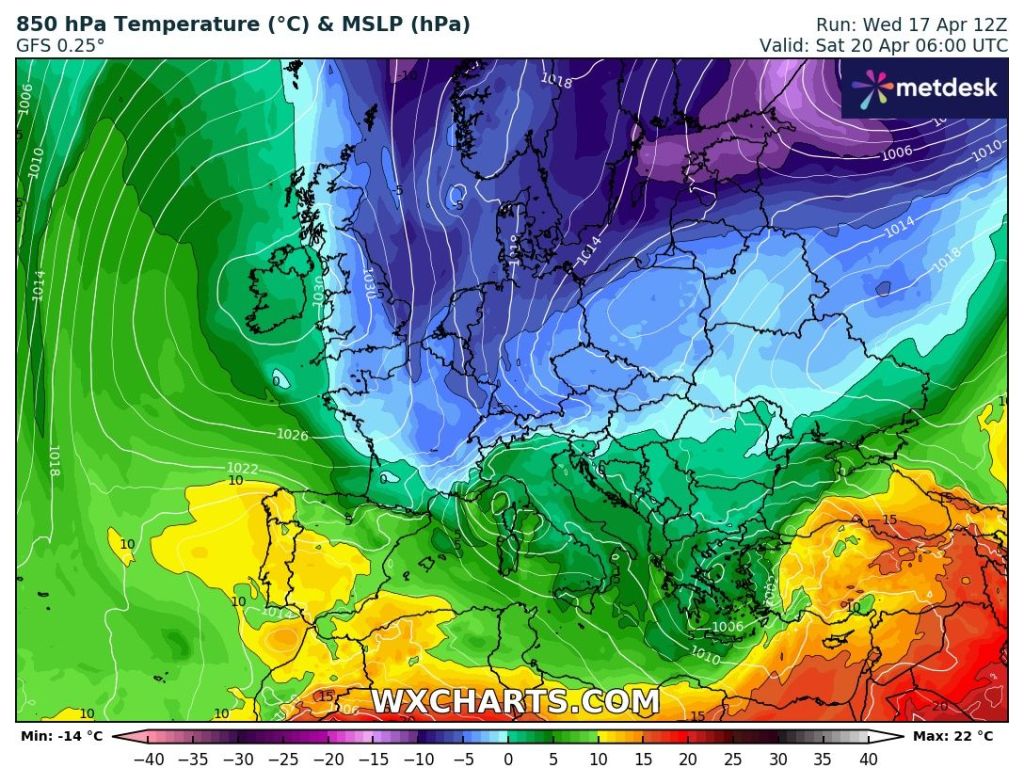
April was not colder-than-average on the thermometer but it did feel it. Image: Met Office.
Despite the poor temperatures, the sun is now gaining strength and is as strong as August, with the UV levels soon stepping up into the high category. So when we do have sunny days and you are out and about, take note, it does not have to be very warm or hot for you to get sunburnt.
First half of April was awful
Thursday: After a calmer day on Wednesday, Thursday will be a windy day once more. The north-easterly breeze will not be as cold as it normally is, as it is sourcing air from the warmer continent to the south-east. It will however, drag some cloud in from the east which will be slow to clear, but it should break and it should be a decent day with some warm sunny spells sheltered from the wind. There’s a chance that a few eastern areas could hang on to some stubborn cloud. In sheltered spots and the further west you are, we will likely reach 20°C. Max 19°C Min 11°C
Friday: After a dry start, cloud will increase from the south and we are expecting some pulses of rain to arrive which could be quite heavy and thundery. With the cloud and rain it will be cooler especially in the breeze. Max 16°C Min 10°C
Long Weekend: Could be worse. Sunday perhaps the best day.Staying on the warmish side.
Saturday: Likely to start off cloudy with a few showers or spots of rain/drizzle. Slowly, as we head into the afternoon, some brighter spells should drift up as cloud clears from south to north. Max 16°C Min 9°C
Sunday: Sunny spells are expected after early mist and cloud slowly lifts. A slight breeze into the afternoon but with more in the way of sunshine temperatures will lift a little and it will feel pleasant but some home-grown showers threaten for later. Max 17°C Min 10°C
Bank Holiday Monday: Some uncertainty this far out, but it looks like low pressure will begin to develop across the UK, albeit quite slack. This means relatively light winds and apart from the odd bright spell, we’re expected to grow some beefy slow-moving showers into the afternoon which could be thundery. Max 17°C Min 9°C
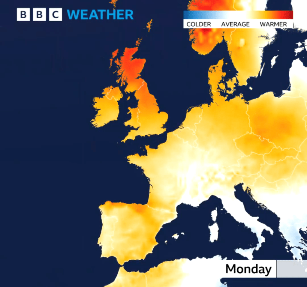
Warmer-than-average on Bank Holiday Mondaybut unsettled. Image: BBC Weather
Outlook: Low pressure to take control of the weather then possibly drift away to the North Sea. Unfortunately, high pressure that was looking like it might build across the country, will only build out into the Atlantic, meaning we will be in a showery airflow with west to north-westerly winds and temperatures remaining around the same. So, in any drier spells with sunshine, pleasant enough but equally some showers.
Small hint that high pressure will drift in later in the week. No sign of any heatwave or “summer blast” as the media keeps reporting but if the high pressure builds then temperatures can slowly rise, day-on-day, but how high all depends on the direction of the wind.
Low pressure next week but will the high topple in by Friday?
Follow @ChadWeather on X for the latest forecasts and warnings.
Thanks as ever for reading. I hope you find my weekly blogs useful.
Thanks,
Jon
Forecast Issued: Wednesday the 1st of May 2024 at 4:55pm.
Busy this week so the blog will be short and sweet.
After more rain this week, and some autumnal weather on Monday, bringing strong winds, 20mm of rain, hail & thunder, the weather is slowly but surely becoming more settled and drier but it’s not a smooth passage. Rain is still in the forecast but the high pressure mentioned last week is coming to our shores to dominate for the weekend. As said on a few X posts, it’s not going to be days upon days of wall-to-wall sunshine nor is it going to be that warm.
Before all that, tonight will be frosty. So gardeners beware.
Thursday: A cold and frosty start for those up early. Sunny spells won’t last too long though as cloud will thicken from the northwest as an area of low pressure topples over the top of the Atlantic high. So patchy rain for the afternoon and lasting into the evening. Temperatures below average. Max 10°C Min 7°C
Friday: A cold-front will have moved south so cooler air across the region and a steady northerly breeze. Bright spells on offer though and it is expected to be mostly dry. Max 10°C Min3°C
The high’s location over the UK; means colder air won’t be too far away to the east.
Weekend: High pressure on top of the UK.
Saturday: The position of the high pressure is crucial and the way it is positioned this weekend means there will be colder air lurking to the east. So west is best in shelter for higher temperatures. Overall dry with sunny spells, cloudier in the east at times. Max 13°C Min 5°C
It’s been 3 months since an area of high pressure was over the UK.
Sunday: It looks set to be cloudier than Saturday as we drag in a northeasterly airflow and with it stubborn areas of cloud. This will make it feel cool. Any brightness further west. Can’t rule out cloud thick enough for drizzle on the tops. Max13°C Min 6°C
Outlook: It would only take the high to drift a little further east for temperatures to be 3 to 4 degrees higher. But, as we enter the working week it looks like the high will drift back west allowing the northerly wind to return bringing colder air again. That said, plenty of dry weather up to midweek then it becomes uncertain; mostly likely outcome is the high drifts away and unsettled showery conditions return.
Follow @ChadWeather on X for the latest forecasts and warnings.
Thanks for reading as always.
Jon
Forecast Issued: Wednesday the 17th April 2024 at 7:37pm