Drier with warm sunshine to end Summer but no heatwave – Thursday 29th August 2024 – Sunday 1st September 2024

Hi all,

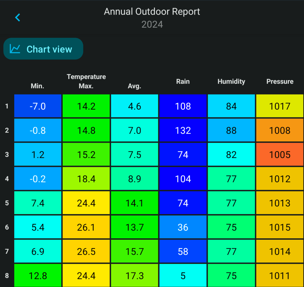
Summer is coming to a close and the “highlight” for me is the lack of sunshine and hardly any prolonged very warm or hot spells. It is also notable that after a very wet Spring, all 3 Summer months will have had below-average rainfall totals.

A drier-than-average Summer

I mentioned last week that Summer would end well and that still looks the case.

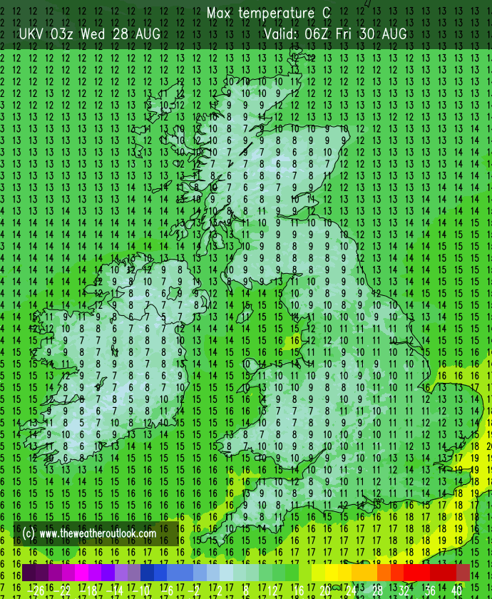
Thursday: A fresher start to the day and it’s expected to be a day of sunshine and a few scattered showers. A steady enough breeze from the west. Not as humid or as warm as recent days. Max 18°C Min 8°C

High pressure builds later this week

Friday: High pressure is now beginning to build so we can expect a dry day with bright or sunny spells and temperatures up a notch after a misty start. Feeling pleasant in the sunshine. Max 21°C Min 9°C

Weekend: Decent enough.

The sun is only as strong as mid-April now, so UV levels are only medium.

Some cool mornings with misty conditions coming up towards the weekend. A sign of autumn.

Saturday: Misty start but high pressure still in charge but drifting away into the North Sea slightly. This means we’ll introduce a bit of a north-easterly breeze. That said, it’ll still be another pleasant day, dry with plenty of sunny spells. Feeling warm in the sunshine and warmer the further west you are, sheltered from the breeze. Max 21°C Min 10°C

Warmer and sunnier weather on the way but due to the wind direction around the high pressure there will be no heatwave.

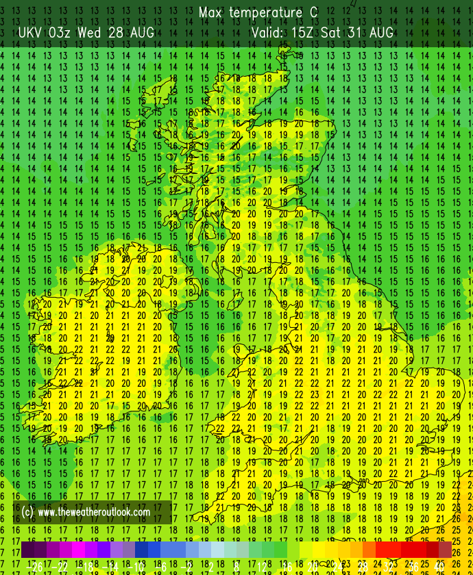
Sunday: Hello autumn. Yes meteorologically-speaking, it’s arrived. Early mist then more in the way of cloud possible on Sunday, but still a reasonable day, warm mostly light winds and sunny spells. Max 22°C Min 11°C

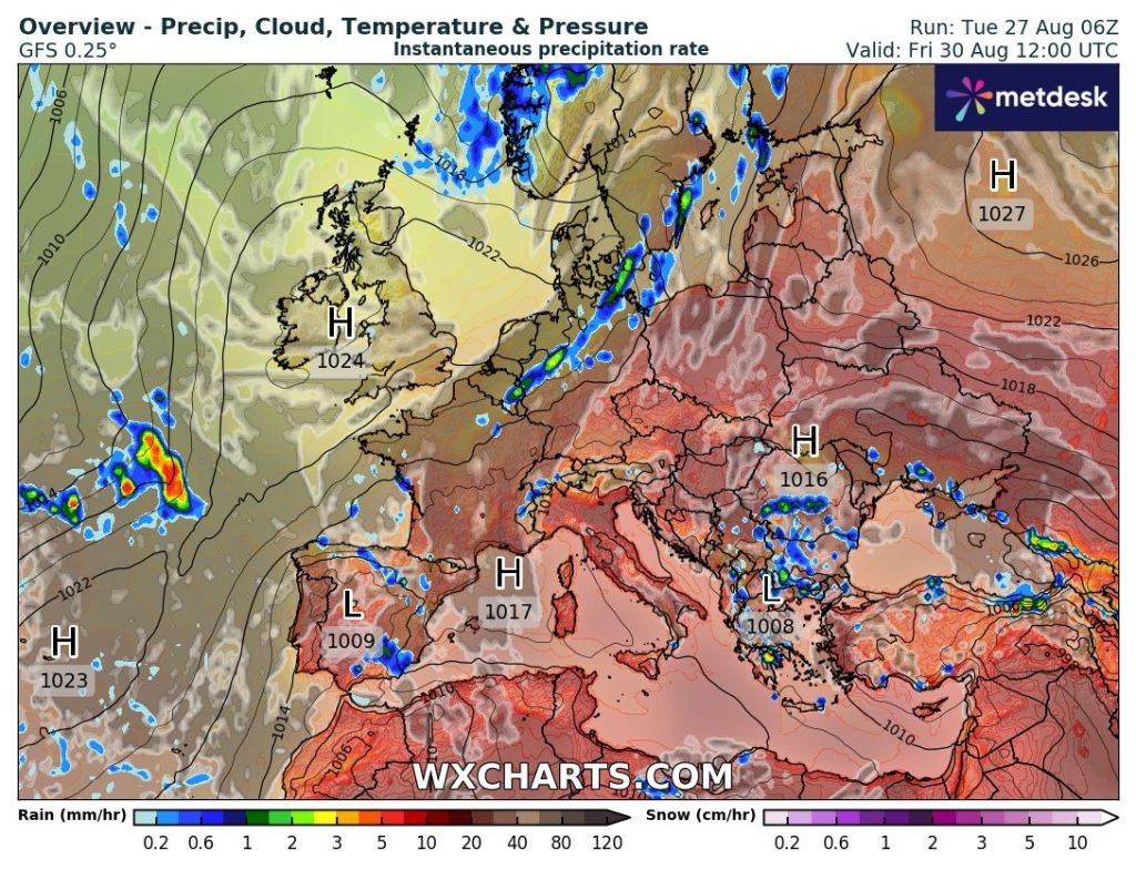
Outlook: A weakening band of showery rain is likely on Monday, but the following few days do look reasonably settled with sunny spells and just the odd shower. What happens towards the end of the week is uncertain, but it’s likely that low pressure returns from the west.

Follow @ChadWeather on X for the latest forecasts and warnings.

Thanks for reading.
Jon

Forecast Issued on Wednesday the 28th of August 2024 at 12:35pm
Images: http://www.wxcharts.com & http://www.theweatheroutlook.com

Unsettled but signs of a good end to summer – Thursday 22nd August 2024 – Bank Holiday Monday 26th August 2024

Hi all,

It’s been a disappointing week with some days letting us know that summer will soon be gone and autumn is coming. We have further wind and rain to come as areas of low pressure bringing unsettled conditions to our region over the coming days.

August 2024 so far, has been much drier-than-average conditions, with only 23mm of rain falling here in Chadderton. The average for the whole month is 92mm. I have records since 2013 and August 2024 currently has an average temperature (day and night) of 16.5°C. This is the second warmest I’ve recorded with only August 2022 (17.6°C) coming in warmer.

One area of low pressure with have the remnants of ex-Hurricane Ernesto mixed in. Apart from some unseasonal windy weather, there’s nothing much to worry about, with the worst of the winds out in the Irish Sea.

Very windy in the Irish Sea and along the western coast for a time during the early hours of Thursday as the remnants of ex-Hurricane Ernesto is mixed in with this low pressure.

Thursday: A wet and windy morning is expected with 40mph gusts as a band of rain moves through. A few hours of heavy rain likely before the afternoon improves with bright spells and a drier and sunnier end to the day. Winds easing into the evening. Max 18°C Min 11°C

Friday: Another area of low pressure looks to form quickly and race across the area. So Friday will start wet with rain during the early hours, turning showery into the morning. Showers will tend to ease later in the day and more in the way of sunshine is expected. This low pressure is expected to bring more windy weather. Gusts could reach 40-50mph during the morning before the winds transfer away to the northeast. Given the time of year, don’t be surprised to see a weather warning issued as the low deepens across northern England. Max 18°C Min 10°C

A lively start to Friday as this low brings some gusty winds for a time before quickly heading into the North Sea.

Weekend: Windy with showers but some sunshine too.

Saturday: With the two recent areas of low pressure moving on, we still remain in a mobile set-up thanks to the Jet Stream. Since we are in between systems, then a day of showers and sunny spells looks to be the order of the day. Windy and fresh air in place. Max 17°C Min 11°C

Sunday: Albeit remaining breezy, on the whole it looks a better day with the odd shower and sunny spells. With the weather in a bit of an unsettled pattern, forecasts can change quickly, so look out for updates on X. Milder air filtering in overnight. Max 18°C Min 13°C

Bank Holiday Monday: A little bit warmer but mostly cloudy with some brightness. Rain won’t be too far away, to our northwest, with the potential for it to arrive later in the day. Breezy. Max 21°C Min 14°C

Outlook: At the time of writing it looks like the weather will become warmer and sunnier for the final few days of August, and perhaps even to start autumn (standard behaviour as the kids return to school) as high pressure slips in from the southwest at times. Of course, it’s a long way off, so take it with a pinch of salt but fingers crossed we can see a late summer-burst with temperatures close to the mid-20s.

Follow @ChadWeather on X for the latest forecasts and warnings.

Thanks for reading as always, much appreciated.
Jon

Forecast Issued: Wednesday the 21st of August 2024 at 12:31pm
Images: http://www.theweatheroutlook.com & http://www.wxcharts.com

A wet Thursday and a brief burst of heat next week but no heatwave – Thursday 8th August 2024 – Sunday 11th August 2024

Hi all,

July’s stats are in. Like June, it was drier-than-average, with only 66% of the average monthly rainfall falling.

July 2024 Stats

July 2024 Stats – 1st to 15th
July 2024 Stats – 16th to 31st
After a wet 2024, June and July have been drier-than-average.

Thursday: We have a small feature moving in from the south west. This is going to bring a wet day with pulses of rain turning showery later. Breezy with temperatures around average but it will feel muggy and with low-cloud on the hills. Max 20°C Min 13°C

Friday: Yesterday’s weather system will move out of the way and a cold-front will introduce fresher air from the west and it will be a day of bright spells and showers. The showers should be well-scattered though and we will get some decent sunny spells in between. The only downside will be, it will be gusty with 35mph winds. Max 20°C Min 12°C

Weekend: Sizzling Sunday.

Saturday: Not a bad day with sunny spells and the chance of a shower later as cloud bubbles up. Breezy. Pleasantly warm. Max 22°C Min 13°C

Sunday: A plume of hot air will move up from the south. That said the first half of the day is expected to see a lot of cloud with very warm-to-hot temperatures developing into the afternoon as cloud breaks and sunny spells arrive. Muggy especially later and overnight. Max 25-27°C Min 16°C

Hot for us on Sunday but by Monday the heat is confined to the SE with 33°C possible

Outlook: The heat will ease away during Monday, but how quickly this happens is still not certain. Could be another hot day with some pleasant sunny spells, or temperatures could be around normal, with a risk of thunderstorms later. The rest of the week looks a bit unsettled with showers and bright spells as well as becoming breezy and temperatures around or just below normal.

Follow @ChadWeather on X for the latest forecasts and warnings.

Thanks,

Jon

Forecast Issued: Wednesday the 7th of August 2024 at 8:27pm

Images: http://www.weathermodels.com